#North Cascades Lodge at Stehekin
Video

flickr
A Face of a Man on a Mountainside (Black & White, North Cascades National Park Service Complex) by Mark Stevens
Via Flickr:
After capturing a few images of Castle Rock and the Moon, I found myself taking in the views while enjoying breakfast. Here I looked across Lake Chelan to this mountainside with a pattern of trees that seemed to hint at the look of a man's face with bushy eyebrows and a mustache...almost like one of the Muppets characters. I later did a conversion to black & white using Capture NX2 where I used some color filters to bring out a much richer tonal contrast for the final image.
#Azimuth 258#Black & White#Bonanza Massif#Capture NX2 Edited#Cascade Range#Central North Cascades#Color Efex Pro#Day 6#Evergreen Trees#Evergreens#Hillside of Trees#Lake Chelan National Recreation Area#Landscape#Looking West#Mountainside#Nature#Nikon D800E#North Cascades#North Cascades Lodge at Stehekin#North Cascades National Park Complex#North Cascades National Park Service Complex#Outside#Pacific Ranges#Project365#Trees#Trip to North Cascades and Washington#Lake Chelan National Recreation#Washington#United States
0 notes
Text
North Cascades Photography – Hike to Stehekin
Along Cascade River Road
The hike from the Skagit Valley up and over Cascade Pass and down along the river to the remote village of Stehekin, on the northern shore of Lake Chelan is a magnificent journey. Sort of like crossing the Misty Mountains to get to Rivendell, there is a lot to see!
It is a 23 mile (37 km) hike from the Cascade Pass parking lot to High Bridge, where shuttle service is available to Stehekin. The entire trip falls with in the North Cascades National Park. Depending upon your level of motivation the basic trip can be done in 2 or 3 days.
However I would recommend 3 or 4 days for the trip. There are several detours along the way that are really to incredible to miss.
The journey starts along the Cascade Loop Highway in Marblemount. The North Cascades National Park Wilderness Information Center is located there. To camp anywhere in the park you need a permit. Here is all you need to know to obtain one! I highly recommend the trail guide: “Hiking the North Cascades” by Erik Molvar (Falcon Press). There are accurate and detailed descriptions of the trails and you’ll find a lot of useful info.
Once that’s all done you’ll be heading up the Cascade River Road to its end, at the parking lot for Cascade Pass. The road gets a bit sketchy at the end, and you wont be able to stop gawking at the views!
#gallery-0-21 { margin: auto; } #gallery-0-21 .gallery-item { float: left; margin-top: 10px; text-align: center; width: 50%; } #gallery-0-21 img { border: 2px solid #cfcfcf; } #gallery-0-21 .gallery-caption { margin-left: 0; } /* see gallery_shortcode() in wp-includes/media.php */
Cascade Pass
Cascade Pass
Doubtful Creek
Doubtful Creek
The trip has one up section, and this is it: 3.7 miles of switch backs to Cascade Pass, an elevation gain of 1,700 feet. The views start near the top, there is one last switchback and then the trail turns east and approaches the pass.
The Pass is a great place for a break, and you’ll see a lot of people there. From this spot, its all down hill to Stehekin!
Dropping from Cascade Pass the trail navigates around the upper basin and soon passes the Pelton Basin campground. It’s not long before the switchbacks start. Whereas the trail up to the pass from the Skagit side is completely in forest, here the trail is exposed to the hot sun.
One nice surprise is the waterfall along Doubtful Creek as it bisects the trail on the east side of Cascade Pass, where there are small pools providing a much needed break and swim.
Many people who make the sojourn from Cascade Pass to Lake Chelan make a straight trip from the Cascade Pass parking area to Stehekin, with no side trips. But there is one of the most awesome valleys in all the North Cascades (Horseshoe Basin) that you should not pass up as you make your journey.
#gallery-0-22 { margin: auto; } #gallery-0-22 .gallery-item { float: left; margin-top: 10px; text-align: center; width: 50%; } #gallery-0-22 img { border: 2px solid #cfcfcf; } #gallery-0-22 .gallery-caption { margin-left: 0; } /* see gallery_shortcode() in wp-includes/media.php */
Glory Mountain from Horseshoe Basin, North Cascades National Park
Horseshoe Basin, North Cascades National Park
Horseshoe Basin, North Cascades National Park
Black Warrior Mine
Black Warrior Mine
Black Warrior Mine
Black Warrior Mine
A short distance from Doubtful Creek is the trail to Horseshoe Basin. You can drop your big packs and day hike up to the Basin, or, if you scored a camp site at Basin Creek Camp, you can stay an extra day exploring Horseshoe Basin and the Black Warrior Mine.
The trail follows the stream up from the trail junction into Horseshoe Basin; it follows a course along the stream, across the stream and in the stream, brushy and wet. Shortly the trail emerges into a clearing where boulders dot the basin floor. Climbing up on the largest, the view is transfixing. The green bowl is surrounded with grandeur, full of color and drama.
Horseshoe Basin, North Cascades National Park
The Horseshoe Basin trail is less than 2 easy miles from the trail junction to the head of the valley and the Mine.
The North Cascades are full of old mining claims; piles of colorful tailings and rusted remains of sluices and Pelton wheels littered about. But I had never visited a mine that I could enter and explore. The Black Warrior Mine operated until the mid-1950′s and is a National Historic Place. There is a sign at the entrance giving a brief history of the mine, the names of the prospectors and misled investors who poured their mostly futile efforts into this hole. There are two main cavernous rooms blasted into the mountain side which make the opening of the mine. One of these “rooms” served as a kitchen while the other was used for workbenches and tools. Wooden supports and floor boards are flooded with water. Old tables and remains of habitation litter the floor. The shaft of the mine runs deep; several miles of tunnel remain, open for any brave person to explore.
When you tire of the basin and continue on your way down the Stehekin Valley you’ll pass several camp sites: Cottonwood Camp was once the last stop on the bus route from Stehekin! Traveling is pretty easy, for the most part you are following along the road following the bus route to Stehekin. But the road has been washed away in several places, replaced by a foot trail.
At Park Creek is another camp and the trail (Park Creek Trail) heads up to Park Creek Pass and continues over and down to Colonial Creek camp, on Highway 20.
Bridge Creek is another large camp along your route and is where you meet the Pacific Crest Trail. From here its 5 miles to High Bridge. Many years ago the entire road washed away in a flood. So for the next 5 miles you’ll be hiking along the PCT!
IF you have the time and energy, plan another day here and make a day trip up the North Fork of Bridge Creek. Its too long to describe here and will be the subject of an entire post soon!
#gallery-0-23 { margin: auto; } #gallery-0-23 .gallery-item { float: left; margin-top: 10px; text-align: center; width: 33%; } #gallery-0-23 img { border: 2px solid #cfcfcf; } #gallery-0-23 .gallery-caption { margin-left: 0; } /* see gallery_shortcode() in wp-includes/media.php */
Mount Logan
North Fork Meadows
Goode Mtn, from North Fork Trail
Walking along the Stehekin River Road is in itself fantastic. The river cuts a deep cleft through the cliffs at High Bridge and the confluence with Bridge Creek creates a wondrous series of cataracts and islands. From High Bridge there is a regular bus that takes you the last 10 miles to Stehekin. Check the Park Service site for the bus schedule.
Your hike must include a visit to the Stehekin Pastry Company. Delicious, fresh treats, ice cream, espresso, friendly staff and a comfortable place to relax…
#gallery-0-24 { margin: auto; } #gallery-0-24 .gallery-item { float: left; margin-top: 10px; text-align: center; width: 50%; } #gallery-0-24 img { border: 2px solid #cfcfcf; } #gallery-0-24 .gallery-caption { margin-left: 0; } /* see gallery_shortcode() in wp-includes/media.php */
Lake Chelan
Stehekin
Pastry Heaven
Welcoming Committee
Organic Garden
Arriving in Stehekin
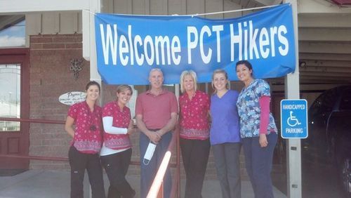
Everything about Stehekin is awesome. Its remoteness (you can only reach it by hiking, ferry boat or float plane), the people are cool, scads of awesome things to see and do…even the Post Office is a neat place to just visit!
Beside the Pastry Company there is a restaurant, a lodge, and a post office. Thru hikers on the PCT mail resupply items to them selves at Stehekin. Its the last stop on the route to Canada. Late in the summer you will often run into some of the PCT hikers as they finish the last few days of their 2,400 mile trek!
When you’re done restin’ and ready to go home you can either walk back the way you came, or catch the Lady of the Lake to Chelan!
Here are a few more images from the trail…
#gallery-0-25 { margin: auto; } #gallery-0-25 .gallery-item { float: left; margin-top: 10px; text-align: center; width: 50%; } #gallery-0-25 img { border: 2px solid #cfcfcf; } #gallery-0-25 .gallery-caption { margin-left: 0; } /* see gallery_shortcode() in wp-includes/media.php */
Sahale Peak from Stehekin River Trail
NCNP Bus
Rainbow Falls, Stehekin
Along the Stehekin River Road
Bridge Creek
Lake Chelan
North Cascades Photography – Hike to Stehekin North Cascades Photography - Hike to Stehekin The hike from the Skagit Valley up and over Cascade Pass and down along the river to the remote village of Stehekin, on the northern shore of Lake Chelan is a magnificent journey.
#cascade loop#cascade pass#horseshoe basin#North Cascades#north cascades national park#stehekin#stehekin pastry company
26 notes
·
View notes
Text
Favorite Trail Towns - Northern Half
This completes a discussion of PCT Trail Towns begun on August 21st and continued on August 23rd. The assessment is, admittedly, arbitrary and subjective. We invite you to share your perspective.
You may advocate for inclusion of stops like Old Station, California and Trout Lake Abbey and Stevenson, Washington. Please tell us about your experience in those places.
Chester - Meredith Rosendahl posted a story about hiker-friendly Chester on August 3, 2013. This little community on the shores of Lake Almanor is a short hitch from the PCT as it crossed Hwy 36. It is the best near-trail place to re-supply between Truckee and Burney with all the amenities for a pleasant zero day.
Drakesbad - I recounted my magical experience at Drakesbad in a post from December 12, 2011. Drakesbad hardly qualifies as a trail town but under the management of Billie and Ed Fiebiger, it was a wonderful and unexpected oasis for me and my fellow hikers. It will always be among my favorite PCT memories.
Burney - This logging town does not really have a viable tourism alternative. It does have the necessary amenities but not a particularly strong connection with the PCT.
Mt. Shasta City/Dunsmuir - Dunsmuir is not far from Castella and Mt. Shasta is about 7 miles further north from Dunsmuir. Both communities have an increasing connection with the PCT. Mt. Shasta City, given its proximity to Mt. Shasta, has an abundance of resources for adventurers. These are up and coming trail towns.
Etna - It has been a while since I have actually stepped foot in Etna. We posted a story about the Hikers Hut on March 13, 2014 which highlighted the increasing connection with PCT hikers. Add the Etna Brewery into the mix and you have a delightful trail town.

Seiad Valley - The quirky community of Seiad Valley lies in the center of the mythical State of Jefferson. Home to the ‘pancake challenge’ and the trail’s crossing of the Klamath River, there is not much more than a post office, store, cafe, and trailer park (with camping options). Unfortunately for many days in the summer the heat can be oppressive.
Ashland - A relatively quick hitch from Callahans and Siskiyou Summit, there is much to be said in support of Ashland as a trail town. It is a tourist town more known for the Oregon Shakespeare Festival and Southern Oregon University than its proximity to the PCT. But, it is a beautiful stopover with ample resources in support of hikers . . . especially those who might be interested in a Zero Day or two. While the connection with the PCT may be somewhat tenuous, other factors make it a special trail town.
Timberline Lodge - Crater Lake Lodge and Timberline Lodge, like Drakesbad, don’t really qualify as trail towns. They are delightful stops along the way and can result in memorable experiences in spectacular settings. You can spend a small fortune or you can just stop in for a drink. I still give the nod to Drakesbad because it is not overrun by other tourists.
Cascade Locks - I have just passed through and can’t really comment although I am a fan of the Eastwind Drive-in and their foot-tall, two pound ice cream cone.

White Pass - The closest that Washington comes to a trail town near the PCT are the ski resorts that the trail crosses near major passes -- White Pass, Snoqualmie Pass, and Stevens Pass. White Pass, the farthest of the three from Seattle, is also the most sleepy of the lot (and my favorite).
Snoqualmie Pass - Being just 40 minutes from Seattle on I-90, Snoqualmie Pass is much too crowded and noisy. While it does have some restaurants and accommodation, the attention is focused on skiers in the winter and transient car and truck traffic year round.
Stehekin - An 11-mile walk or a park service bus ride from the High Bridge Ranger Station on the PCT, Stehekin is stunningly located on the shores of Lake Chelan. Home to the Stehekin Pastry Company, this little trail town is one of the few legitimate trail towns in Washington and often the last stop before the final push to the border for NOBO hikers.

#Chester#Stehekin#Snoqualmie Pass#Trail towns#Timberline Lodge#Ashland#Dunsmuir#Mt. Shasta City#Burney#Old Station#Drakesbad#Seiad Valley#State of Jefferson#Pancake Challenge#Cascade Locks#White Pass
7 notes
·
View notes
Photo


8/24 - 8/4
Mile 2461.5 - Mile 2660 - 198.5 miles
I slept until about 9, which felt heavenly. The bunkhouse was fresh with cold morning air. Jerry, the trail angel who runs Hiker Haven, drove all the hikers into town to have breakfast. We sat around a big round table at the inn and I ate a giant plate of scrambled eggs with a warm homemade biscuit. I was so content. One of Jerry’s friends, Bill, walked in as we were eating and had breakfast with us, eventually offering to let Dustin and I use his washing machine, since Jerry’s wasn’t working. The town of Skykomish is about 200 people. The high school, middle school and elementary school are all contained in one building. The girl who gave us a ride to town yesterday told us that she graduated from that high school and that there were six people in her graduating class. When we told Jerry this he said, “Oh, wow, that was a big one.”
When we finished breakfast Jerry dropped Dustin and I at Bill’s. We did our laundry and made phone calls and googled things for a few hours. I sat by the Skykomish river and talked on the phone, watching the light catch on the water, watching tiny birds flit from one bank to the other.
When our laundry was done, Bill drove us back to Hiker Haven where we watched movies, ate copious amounts of gas station microwaveable food and basked in our cleanliness.
The next day all the hikers got ready to leave. We got to town, ate breakfast and did phone chores, scrolling and scrolling in service land. Supposedly there’s no service until Manning Park, in Canada, 188 miles away. I ordered shoes and a new tent since my zipper broke. We got a ride back to the trailhead at Stevens Pass and scrolled some more, trying to squeeze every last google out of the internet. We hiked out around 2:30, later than we had planned but it was nice to have a relaxing day. This last section of trail into Canada is tough, notoriously so. We hiked a difficult 10 miles to camp, our feet aching after the short day. We pitched our tents next to a lake, cooked dinner and went to bed.
My alarm went off at 5:30 and I ignored it stubbornly. I was up by six and walking around 7:15, later than I would have liked. The day involved lots of climbing and descending, over and over again. The terrain was tough, roots and rocks nestled in ditches where water had eroded the trail into little canyons, barely wide enough to put both of my feet inside side by side. It was painstaking work. My pack heavy with five days of food didn’t help. Huckleberries grew dense along the sides of the sunken trail. When I felt discouraged or tired I stuffed my face with a handful. We took more breaks than usual, stopping for water every five-or-so miles just to take our packs off, sit down, and drink a liter of water. We ate lunch at a beautiful lake that sat low in a basin of gray boulders. The water was a stunning blue, bright and deep at the same time. After I ate a tortilla with cheese and hot sauce for lunch we plowed on, climbing and descending for twelve more miles to camp. We only hiked 21 miles but it was arduous work. We finally got to camp at 7, in a little saddle at the top of a climb. I cooked spicy pasta shells and set up my tent while they soaked in boiling water to finish cooking. I ate them gleefully and chatted with a Swiss couple camped in the same spot. The setting sun cast these beautiful rays over everything, like it had spun the light with gold and laid it out over mountains and tall spruces and firs and patches of dirt.
My alarm went off at 5am. I sleepily ate my breakfast and left camp at 6:15. The morning was dangerously warm and the rest of the day followed suit. There was a lot of climbing today, steep inclines leading to breezy passes. The trail was rough, rooty and rocky and carved out of the earth like yesterday. Sweat ran down my face, dirt gathered on the insides of my elbows, stuck to the sweat on my legs. We stopped for lunch at a creek and I hid in a patch of shade. A couple hiked up to me while I was eating. “Is that real food?” a middle-aged lady asked.
“If you count cheese and cheetos and taco bell hot sauce in a tortilla as real food?” I mumbled back at her through my mouth full of junk food.
After lunch I washed my feet in the creek, put my pack on and hiked, climbing again, dealing with many large blowdowns. I took a break at a creek three quarters of the way up the hill. I killed flies that bit my legs. I watched an ant carry a dead fly body in a large circle, pulling it around, yanking it through tufts of grass with all its might. It had no idea where it was going.
We climbed a bit more and then descended a couple of miles to camp for a 23 mile day. The backs of my knees were sore from all the climbing. I made dinner and pitched my tent. Dustin made chocolate pudding that didn’t really set but we ate it anyway and it was better than not having any pudding.
I didn’t sleep very well, and I was up at 5 and walking at 6:30. The morning was warm again and I knew we were in for another hot day. I climbed up and over a pass as light slid onto the mountains. A warm breeze passed over the mountainside. I lumbered on into the morning, tired, my feet hurt, my pack straps digging into my shoulders like they do. In a couple of hours I was dripping sweat, climbing 1500 feet in the humid sun. When I got to the lunch spot, a little campsite perched almost at the peak of the climb, it was half-shaded. I was so happy. I laid on my tyvek, feeling the weight of my body released from me feet, my skin hot. I ate lunch and then dug dirt out from under my toenails. I hiked out around 2, stopping at a little stream and pouring water over my head. It was so cold. I began a long descent that left my feet angry and painful. The forest around grew huge and tall and dense, moss carpeting the entire floor, growing over rocks and downed trees. It looked like one huge blanket, like snow. It consumed everything. Giant ferns and wide green leaves grew all around. In some places leaves grew into little archways over the trail, tinting the sunlight green. I felt like I had entered another world, like I was a bug, something microscopic, crawling through some super-sized version of forests I thought I knew. At 6:45 we got to camp at the Suiattle River for another 23 mile day. It was raging and swollen and brown. The water munched down over big boulders, slapped against rocks on either bank, making it difficult to get water. I cooked dinner, burnt it, ate it anyway. I was so hungry. Today felt just as difficult as yesterday. As I washed my pot I felt the exhaustion creeping up through all of my bones and I hurried off to bed.
At 5am when my alarm went off I could feel that deep tired trying to pull me back into sleep. I begrudgingly got up and moving in the warm morning. I began a monstrous climb, 4,000 some feet. The incline wasn’t terrible but my body was exhausted and painful. My feet hurt in so many different places and ways. As the day heated up I got pack rash again. The straps of my pack began to chafe my armpits. I sat down for lunch and was greeted by biting flies. I killed so many of them and they continued to appear from whatever terrible place biting flies materialize. I filtered water and kept walking, the day beginning to boil. It was so humid. Smoke hung low in the atmosphere, trapping all the heat. My hip began to hurt. I listened to music to try and power through the next few miles and started crying in the middle of the trail. A huge fly whizzed around me, hanging in front of my snotty face. I wiped the snot from my nose and then wiped my snot-covered hand on a tree. I walked and snot-rocketed and walked and snot-rocketed. Washington is hard. I forded a creek and the icy water filled my shoes, which felt great on my aching feet. I sat down on the other side of the creek and filtered water. I talked to Dustin and felt a little better. there were only three more miles to camp. A hot wind followed me the whole way. I got to camp around 6, laid out my tyvek and collapsed on it. I laid on my back feeling the pressure release from my feet. I took off my socks and scraped some of the dead skin off my feet.
I filtered water and made dinner and ate snickers bars and felt the heaviness of exhaustion pooling behind my eyelids. I crawled into my tent happy that there were only ten miles left until Stehekin tomorrow.
We got up at six and hiked the last ten miles to town, arriving early to the spot where the shuttle would pick us up. A girl I met my second day on trail was there. She was hiking south. It was so cool to see her, in the same way it had been cool to see Blue.
A white bus pulled up to the group of hikers and a middle-aged guy wearing a ten-gallon hat and a short-sleeved button down climbed out. He stretched his legs, we got on the bus, and got out at the infamous Stehekin Bakery. I got a lemon bar, a piece of hawaiian pizza and a giant stromboli filled with ham and swiss cheese. Dustin got the same one filled with pesto, onions, mushrooms and swiss cheese. We split them and felt like we could die happy. Then we got back on the bus and got dropped off a few miles down the gravel road at the North Cascades Lodge, where there’s a campground and a store and a public shower/laundry building. I took a great shower, did my laundry, spent too much time at the post office and ate a giant burger with beer battered fries. We stayed up late talking with other hikers and then wandered back up the steep dirt road to the campsite.
I awoke to a bright tent, the day becoming warm even in the constant breeze that tumbled over the little town of a Stehekin. I broke down camp and went down to the deck of the lodge. When Dustin got there some kind of debacle was going on about a bus driver not having a CDL, and no busses were running, so we walked the 1.6 miles to the bakery. We got stuck in front of the pastry case again, eyes like saucers, salivating at bacon-swiss stromboli, carrot cake muffins piled high with cream cheese frosting, chocolate zucchini cake, chai coffee cake, six different kinds of cookies, etc. I ate so much. I felt like I did in Big Bear Lake, hundreds of miles ago. I laid in the fetal position on the grass outside, again. Other hikers laughed at me, again. At least this time nobody asked to take my picture. I packed out two pieces of pizza for dinner.
A bus came around 11:20 to take us to the trailhead. All of the food jostled around in my stomach. I curled up in the seat and tried to stop thinking about how sick I felt. I sat around at the trailhead for a few minutes and then decided there was no better way to cure a stomach ache than a 29 mile climb, so I started walking.
A woman we met in Skykomish named Hot Thumbs has been hiking with us for a few days now. The three of us hung out at a creek and talked for a bit. I saw my first bear on the PCT today. It was a bit small. I think it was a young adult bear. I rounded a corner and it was in the trail eating berries off bushes. I startled it and it ran further down the trail.
“Heeey bear,” I called, trying to make it run off the trail. It looked at me.
“HEY BEAR,” I yelled. It ran off onto the hillside, ambling over bushes and taking swooping bites of berries as it passed them. It was cute.
We reached our campsite around 6:30 for a 13 mile day. I ate my pizza and taught Hot Thumbs how to tie a bowline knot.
The trail to the site was covered in bear scat. A ranger had warned us that this area was densely populated with bears who didn’t care about people being there and would do anything to get to their food. We hung everything we had that smelled from a tree and hoped for the best.
I dreamed about bears and woke up at 6, the sleep still so close, heavy on my brain. We packed up and hiked out into the dense forest in the cold morning. After a few miles we crossed a highway that led to a trailhead parking lot and caught up with some hikers we met in town, Hats and Butter. Hot Thumbs and I walked with them into the parking lot where we were greeted with trail magic. We each had a beer and sat in the parking lot talking and procrastinating the long climb ahead of us. We let the day warm up a bit and then started the climb. It went on and on through the forest that soon opened up and had us on sandy ridge line, a row of peaks opposite us. Can something be bright dark gray? If it can, that’s what they were. Everything was so bright against the deep blue sky. Everything green was so stark against the pale pinks and browns of the rocks that lined the dusty trail. I hiked with Hats for a bit and then Butter for a while. We talked and marveled at the snow-covered mountains in the distance, the plummeting valleys below. The day was so windy, my hat blew off at one point and I had to tip toe down a steep hill of loose rock to retrieve it. I love that hat so much.
After a while I crossed a tiny stream to find John, who I had hiked around for a while in the desert, sitting on the other side. It seems like every day I see someone from trail past. It’s really nice. We caught up for a bit and then I hurried off to camp. Being a Friday, all the weekenders were out and the campsites were all full of big tents and very few people taking up lots of space. All the thru hikers end up cowboy camping where they can fit, which if you think about it is a really funny scenario. Sometimes if the trail is really packed on the weekend and we can’t find a campsite, Dustin and I shake our fists and, when we’re out of earshot, yell “get off my lawn” in an old man voice.
I got to camp around 7, made mashed potatoes, set up my sleeping pad on the ground and pulled my sleeping bag around me. I listened to the sound of the Methow River next to me and watched one star in the sky above become ten, twenty, thirty in a little opening in the trees. Another hiker twenty feet away began to snore loudly. I put my earplugs in and hoped no bears would bother me in the night.
The first light woke me as stars began disappearing. The sky turned light blue and I ate a pop tart and drank instant coffee in my sleeping bag as everyone else in camp went about their morning chores. I started walking around 7:30. The morning was chilly again, it felt good to shift into fall, away from the heat of summer that crept in at eight in the morning and lingered all day. I stopped at a stream before a 2500 foot climb to filter water. I powered up the climb, stopping a couple of times to take in the views of giant mountains opposite me. They were all angled and brown and dark gray, snow still resting in little pockets on their faces.
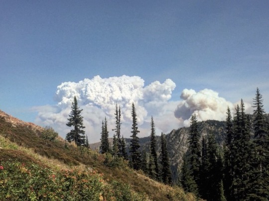
Once I was on the ridge, wind swept over the side of the mountain. Big white plumes of smoke from two forest fires extended from other ridges to the north and the east. I stopped to eat lunch with Dustin and Hot Thumbs at a little spring in a sunny meadow. We huddled in a patch of shade. I ate cold ramen and washed my socks in the icy water. I left a note for Hats and Butter telling them where we were camping that night.
A couple of hours after lunch, Hot Thumbs and I hit trail magic: a canopy set up at Hart’s Pass campground with coolers full of fresh cut watermelon on a table. We drooled
over that for a while and then kept walking, climbing and descending and climbing to camp. Nine tents were already pitched in the field, all weekenders, so we cowboy camped on a ledge above the site.
The moon was bright all night. In the morning a chorus of pikas woke us to see a beautiful yellow-pink sunrise. The sun was fiery orange as it peeked above the ridge in front of us. It had gotten quite chilly at night so we got up slowly. I brewed coffee thanks to the cup and reusable filter Hats and Butter had given me. This was the best treat I’ve had in so long: to drink hot coffee in my sleeping bag on this beautiful ridge watching the sky light up the day. I felt so soothed and wonderful even though my skin was dirty and my feet were prickling from all the miles I’ve walked and I smell like an old running shoe.
Dustin left camp first and Hot Thumbs and I slowly got our things together and left about a half an hour later. We climbed up and over a pass, then descended to cross Foggy Pass (it seems like all the passes in Washington are gloomy: Rainy Pass, Foggy Pass, Windy Pass, the list goes on). I filtered water from a creek, talked to a day hiking couple and their dog, and ran into hikers all day who had chosen not to go into Canada and had already been to the monument. This was weird. This is the end of the trail for so many people. As they talked to me and walked away from me I could feel their energy just colossal and booming in a way that mine couldn’t be yet. Even though I still have miles to hike after I get to the monument, it feels enormous to be able to touch one end of it tomorrow, to bring tangibility to all of these miles, to remember where I was four months ago when I touched the one at the southern terminus. All of the moments I’ve experienced between the two have already been stupendous, difficult, agonizingly beautiful, mind-numbingly fatiguing and filled with infinitely varying amounts of hope and sorrow and joy and wonder. I felt lucky that there were more ahead of me. I knew that if I had to be done today, that if I didn’t have a reason to hike more miles, to keep being on the trail, that I would be deeply sad. My immediate physical pain would be relieved if I didn’t have to continue waking up and walking so much every day, but I would spend so much less time in the sun, so many fewer moments watching the world unfurl itself before me in such a pure, silent, slow way. I would miss drinking cold mountain spring water, I would soon take for granted all the moments I spent squeezing water from one bottle to another through my filter, I would become accustomed to the luxury of turning a knob on a faucet and filling a glass of pre-treated city water. I would be forced to face the world as I’ve grown up knowing it: loud, busy, fast, demanding, stark and harsh in opposite and tragic ways from this one I’ve lived in for four months. This is what people mean when they when they say that thru hiking will break your heart and ruin your life. I have spent the last few days contemplating the progress of human kind in the context of this walk. People who walk long trails often find that it needs to become part of their life permanently. Why is this? I keep visiting this question. Weren’t the earliest humans nomadic? Is this similar to the way they lived? After walking so many miles it seems like it could be true, going where the weather is suitable, following reliable food, bearing witness to the constant pattern of nature accumulating and dying and being born again that is life. We have moved so far from this as a species that to live in this way would be defined as unsuccessful, unproductive or foolish. How could a person make a “decent living” if they spent so much time in nature? I guess that depends on how one defines living decently.
Thru hiking ruins a person’s concept of leading a successful life as society defines it. It brings people back to the essence of whatever it was to be human thousands of years ago.
I watched smoke plumes from a wildfire extend into a bright blue sky from behind a jagged gray ridge. This fire was caused by humans, rangers had told me a couple of days ago. The smoke was so dynamic, so many different textures, puffy and flat and dense and thin as the wind spread it across smaller peaks in the distance. Some of the smoke was bright white, other smaller plumes were an old yellow, and another was a deep gray. Hot Thumbs and I stood at the last 7000 foot peak on the PCT in Washington. This was going to be her last night on trail, her last big view. We could see the trail below us snaking down the side of the mountain. Another hiker, Chubs, pointed to some peaks in the distance and said, “That’s Canada.”
We just stood there and looked. We savored that last northern Cascade peak, the wind swirling around us, our shirts flapping in the breeze. We descended to Hopkins Lake and filtered water as the sun sank behind the mountain, then hiked the last couple of miles to camp. I made pesto pasta, drank electrolyte water and ate a snickers bar. I blew up my sleeping pad on my sheet of tyvek and watched the stars come out one by one.
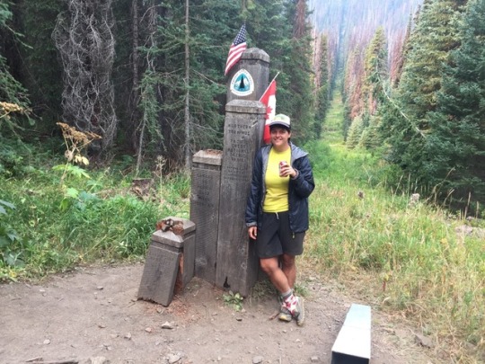
I woke up and made coffee, the process spilling it all over my tyvek. I drank it and watched the pale sky lighten, smoke dense in the mountains north of us. We got to walking soon and descended into it. This was the first time I could really smell the smoke. In four miles I heard clapping and cheering and walked into the tiny clearing where the monument was. It was four little wooden pillars and one metal one, an American flag on one side and a Canadian flag on the other. I walked up and looked at it. “Touch it!” yelled someone behind me. My hand reached out for it and I hesitated just above one of the pillars. Here it was. One end of this thing. I put my hand gently on the pillar. I froze there for a moment, I looked at the clear-cut line of trees behind the monument, the dividing line between two nations. What a moment this was. I was still glad I wasn’t done yet, but it felt good to celebrate all the miles I had hiked anyway. I drank a beer and Dustin, Hot Thumbs and I took pictures. Then we hiked the last smoky eight miles to Manning Park, a resort where we ate giant burgers. We showered and then Dustin and I said our goodbyes to Hot Thumbs who was taking a bus to the airport to go home. Then we got our longest hitch of trail into Vancouver, about 140 miles, during which I got a smoothie and a free beer and chips and dip. We got to Vancouver at about 9pm and met up with Dustin’s friends who generously let us stay with them for a couple of nights.
In a few days we’ll take a bus to Sacramento, resupply, and hike into the High Sierra from Kennedy Meadows. I can’t wait.
1 note
·
View note
Text
The questions surrounding Pacific Crest Trail resupply in this year’s Pacific Crest Trail Thru-hiker Survey were expanded to better answer what’s one of the trails biggest challenges (at least in the planning stages).
Hopefully this information will help to lessen the unnecessary stress that hikers put themselves through when attempting to plan how to get more food and supplies into their packs whilst tramping through PCT wilderness.
Remember, this information is sourced from actual PCT hikers and is more than just one dude’s opinion (I’m that dude), but if we come across any anomalies in the data I will be sure to add my two cents (because I can’t afford more).
NOTE: A list of the different categories I broke hikers into and how they are identified can be found at the end of this post.
What your future holds.
TO MAIL OR NOT TO MAIL?
First, hikers think they must decide how many resupply boxes to send.
THIS IS WRONG.
Unless you’ve chosen to mail yourself ALL your resupply boxes, which I would definitely NOT recommend doing unless you have a very legitimate reason (e.g. you only eat Vegemite and dehydrated free-range poultry), then the only boxes you’re going to want to concern yourself with sending before you begin your hike are those you’ll need in the desert.
Instead, what you do is MAIL YOURSELF BOXES FROM THE TRAIL. When you get to a stop with a large and affordable enough selection of hiker food you buy yourself an extra resupply, pack it into a box, and mail it up the trail.
This saves you the stress of needing to pack everything into boxes beforehand and allows you the flexibility to mix up your resupplies on the trail (because chances are your taste/diet will change as you being to turn into an unstoppable hiking machine).
STRATEGY | 75% mailed SOME resupply boxes, 16% mailed ALL, 9% mailed NONE
FINISH – AVERAGE BOXES SENT | 12 (σ = 8.5)
Let’s go with the average and mail 12 resupply boxes. Where do we want to send them?
According to this year’s class, the places you’re going to want to mail your twelve resupply boxes are (in geographical order from south to north):
Warner Springs (Desert) – Mile 110
Kennedy Meadows (Sierra) – Mile 703
Sierra City (NorCal) – Mile 1,198
Crater Lake/Mazama Village Store (Oregon) – Mile 1,830
Shelter Cove (Oregon) – Mile 1,912
Big Lake Youth Camp (Oregon) – Mile 2,002
Timberline Lodge (Oregon) – Mile 2,107
Trout Lake (Washington) – Mile 2,234
White Pass (Washington) – Mile 2,303
Snoqualmie Pass (Washington) – Mile 2,402
Stevens Pass/Skykomish (Washington) – Mile 2,476
Stehekin (Washington) – Mile 2,574
RESUPPLY BOXES
So for the ENTIRE STATE of California you are only sending yourself THREE BOXES.
A lot of hikers also say that they wish they would have SENT BOXES FROM THE TRAIL instead of preparing all their resupplies ahead of time.
I know this might sound like a scary idea (does it really?), but trust me, it’s a smart move.
TOTAL PER SECTION:
DESERT: 1 (Warner Springs)
SIERRA: 1 (Kennedy Meadows)
NORCAL: 1 (Sierra City)
OREGON: 4 (Crater Lake, Shelter Cove, Big Lake Youth Camp, Timberline Lodge)
WASHINGTON: 5 (Trout Lake, White Pass, Snoqualmie Pass, Stevens Pass, Skehekin)
That’s it? Yes, that’s it.
PRO TIP: Use something flashy on your box so it stands out.
And the idea that you don’t need to mail a lot of resupply boxes isn’t only coming from people who mailed themselves far too many. An entire 12% of people who sent FEWER than the average of 12 said they would have preferred fewer boxes when asked what about their resupply strategy they would have changed.
I also asked hikers where they would have rather mailed themselves a box instead of buying locally. This could be either because the selection isn’t very good, the prices are high, or the store owners are assholes.
The top responses were (in geographic order from south to north):
Warner Springs (Desert)
Agua Dulce (Desert)
Vermilion Valley Resort (VVR) (Sierra)
Kennedy Meadows North (NorCal)
Sierra City (NorCal)
Belden (NorCal)
Mazama Village Store (Crater Lake) (Oregon)
Stehekin (Washington)
Agua Dulce, VVR, Kennedy Meadows North, and Belden did not make the “send a box here” list, so if you’re planning on resupplying at one of these locations (our “average resupply plan” is below) then you may want to consider sending an additional box.
Lastly (for this section), I asked what CHANGES hikers would make to their resupply strategies?
Mail fewer boxes (overwhelmingly).
Mail boxes from on then trail instead of ahead of time.
Send less food in resupply boxes.
Resupply more frequently.
WHAT FOOD TO SEND
Okay, but once you have your boxes, what should you be PUTTING INSIDE them? Some of the TOP COMMENTS I got from hikers about their resupplies said the following:
More variety in boxes (you can only eat so many Snickers and tortillas)
More dehydrated foods in boxes (if you have the means, then do it)
Less food in boxes (you’ll be stopping more than you think)
Healthier food in boxes (empty calories only get you so far)
More snacks, fewer meals in boxes (forget about the idea of “meals”)
#gallery-0-5 { margin: auto; } #gallery-0-5 .gallery-item { float: left; margin-top: 10px; text-align: center; width: 33%; } #gallery-0-5 img { border: 2px solid #cfcfcf; } #gallery-0-5 .gallery-caption { margin-left: 0; } /* see gallery_shortcode() in wp-includes/media.php */
Looking for meal suggestions? The favorite (and least favorite) foods as reported by hikers was as follows:
FAVORITE SNACKS:
Tortillas
Snickers
Ramen
Candy
Nutella
Mountain House
“NEVER AGAIN” FOODS:
Clif Bars
Idahoan Potatoes
Pop-Tarts
Assorted bars
Tuna
Oatmeal
HOW FREQUENTLY TO STOP
Another question on the resupply agenda is “How often do I want to resupply?”
This is incredibly difficult for hikers to accurately predict before starting the trail because few people know what their pace is going to be or what their still unknown trail friends will want to do (just remember to hike your own hike).
Stopping more frequently means less time spent hiking (which before starting your hike might sound like a bad thing), but it also means that you will not be carrying as much weight (in food) between your resupplies (lighter = better).
So how many stops did the Class of 2016 make on their thru-hikes?
FINISH – AVERAGE RESUPPLY STOPS MADE | 26 (σ = 6.5)
And in their comments, many said they would have liked to resupply MORE OFTEN.
So let’s say that we’re going to just take the average plus one standard deviation to accommodate for the “more often” factor. That gives us a total of 32 resupply stops. That means you’re resupplying EVERY 83 MILES (134 km) on average. If you don’t want to carry more than seven days worth of food (which is a lot), then you would need to be doing an AVERAGE OF 11.8 miles per day (18.9 km).
How many miles per day did this year’s PCT Class average? 19.6 miles / 31.5 km.
Seems reasonable enough.
Good thing I haven’t begun to hate Snickers yet.
THE AVERAGE PCT RESUPPLY PLAN
Based on survey responses we can piece together what an “average” Pacific Crest Trail hiker’s resupply looked like for a 2016 thru-hike.
Now that we know how many boxes we’re mailing (12), where we’re mailing them to, what’s going in them, and how often we want to stop for resupplies, we can focus on arguably the most important question: where exactly are we going to stop?
A look we shall take, yes?
NOTE: The percentage of hikers who resupplied at each of the following places has been coded as follows: OVER 66%, 33-66%, LESS THAN 33%. Also, stops are listed in geographical order from south to north.
DESERT
Campo (42%)
Mount Laguna (88%)
Julian (55%)
Paradise Cafe (77%)
Warner Springs (90%)
Idyllwild (94%)
Anza (1%)
Cabazon (22%)
Big Bear City (44%)
Big Bear Lake (40%)
Big Bear Hostel (27%)
Wrightwood (85%)
Acton (47%)
The Saufley’s/Agua Dulce (78%)
The Anderson’s (70%)
Hikertown (74%)
Tehachapi (80%)
Majove (18%)
Ridgecrest (3%)
Kernville (1%)
Onyx (7%)
Lake Isabella (45%)
SIERRA
Kennedy Meadows (94%)
Lone Pine (35%)
Independence (45%)
Muir Trail Ranch (15%)
Bishop (57%)
Vermilion Valley Resort (49%)
Red’s Meadow (50%)
Mammoth Lakes (75%)
Tuolumne Meadows (85%)
Yosemite Valley (1%)
Lee Vining (5%)
Sonora Pass Resupply (1%)
Bridgeport (16%)
Kennedy Meadows North (45%)
Markleeville (3%)
For more on the Kennedy Meadows to Vermilion Valley Resort resupply, find my detailed post here.
If you’re interested in my PCT resupply for each section then check out the following posts:
PCT Progress Report I: The Desert
PCT Progress Report II: The Sierra
PCT Progress Report III: NorCal
PCT Progress Report IV: Oregon
PCT Progress Report V: Washington
NORTHERN CALIFORNIA
South Lake Tahoe (90%)
Echo Lake (26%)
Tahoe City (9%)
Soda Springs (7%)
Truckee (32%)
Sierra City (90%)
Quincy (20%)
Chester (57%)
Drakesbad (45%)
Old Station (71%)
Belden (83%)
Burney (38%)
Burney Falls Guest Ranch (2%)
Burney Falls (64%)
Castella (42%)
Dunsmuir (23%)
Mount Shasta (55%)
Etna (73%)
Seiad Valley (85%)
OREGON
Callahan’s (49%)
Ashland (85%)
Fish Lake (22%)
Lake of the Woods Resort (3%)
Mazama Village Store (Crater Lake) (95%)
Diamond Lake Resort (10%)
Shelter Cove Resort (79%)
Odell Lake Resort (7%)
Elk Lake Resort (38%)
Sisters (29%)
Bend (50%)
Big Lake Youth Camp (61%)
Olallie Lake Resort (55%)
Government Camp (13%)
Timberline Lodge (86%)
Cascade Locks (93%)
Hood River (8%)
Portland (1%)
WASHINGTON
Trout Lake (51%)
White Pass (93%)
Packwood (23%)
Snoqualmie Pass (96%)
Stevens Pass/Skykomish (71%)
The Dinsmores (22%)
Leavenworth (4%)
Stehekin (93%)
Mazama (9%)
Winthrop (10%)
That’s a lot of information.
How would our average Pacific Crest Trail thru-hiker have used his or her 32 resupply stops based on this information?
It would look something like this (COLORED NAMES indicate that sending a box was prefered by this year’s class):
DESERT:
Potential resupply options.
MILE 110: Warner Springs
MILE 179: Idyllwild
MILE 265: Big Bear City
MILE 364: Wrightwood
MILE 454: Agua Dulce
MILE 558: Tehachapi
MILE 652: Lake Isabella
SIERRA:
MILE 703: Kennedy Meadows
MILE 790: Independence
MILE 831: Bishop
MILE 903: Mammoth Lakes
MILE 942: Tuolumne Meadows
MILE 1018: Kennedy Meadows North
NORTHERN CALIFORNIA:
Sierra City’s overpriced store.
MILE 1093: South Lake Tahoe
MILE 1198: Sierra City
MILE 1334: Chester
MILE 1378: Old Station
MILE 1424: Burney Falls
MILE 1507: Mount Shasta
MILE 1606: Etna
MILE 1662: Seiad Valley
OREGON:
MILE 1727: Ashland
MILE 1830: Mazama Village Store (Crater Lake)
MILE 1912: Shelter Cove Resort
MILE 2002: Big Lake Youth Camp
MILE 2107: Timberline Lodge
MILE 2155: Cascade Locks
WASHINGTON:
Seiad Valley store.
MILE 2234: Trout Lake
MILE 2303: White Pass
MILE 2402: Snoqualmie Pass
MILE 2476: Stevens Pass/Skykomish
MILE 2574: Stehekin
WHERE DO WE LIKE?
I also asked about hikers’ FAVORITE and LEAST FAVORITE resupply points. Here’s what we came up with (for each section):
FAVORITE RESUPPLY POINTS
DESERT: Idyllwild
SIERRA: Bishop
NORCAL: South Lake Tahoe
OREGON: Ashland
WASHINGTON: Stehekin
HONORABLE MENTIONS
Mammoth Lakes (Sierra)
Wrightwood (Desert)
LEAST FAVORITE RESUPPLY POINTS
DESERT: Hikertown
SIERRA: Kennedy Meadows
NORCAL: Belden
OREGON: Shelter Cove
WASHINGTON: Snoqualmie Pass
HONORABLE MENTIONS
Seiad Valley (NorCal)
Sierra City (NorCal)
And lastly, what about hitchhiking into town? I asked hikers what resupply stops (if any) they had difficulty making it to from the trail. The top responses were (from south to north):
Lake Isabella (Desert)
Independence from Kearsarge Pass (Sierra)
Bishop (Sierra)
Etna (Northern California)
Trout Lake (Washington)
If there is ANYTHING you can think of that would make this information more useful (or any more resupply-related cross-referencing you would like to see), then please LEAVE A COMMENT and let me know.
FOR MORE ON PCT RESUPPLY, CHECK OUT THESE POSTS.
Here are the labels used to differentiate hiker segments in this post:
FINISH: Everyone who completed the entire PCT (regardless of direction hiked)
#mc_embed_signup{background:#fff; clear:left; font:14px Helvetica,Arial,sans-serif; width:100%;}
ENTER YOUR EMAIL TO PARTICIPATE IN NEXT YEAR’S SURVEY
PCT Class of 2016 Survey: The Resupply Guide The questions surrounding Pacific Crest Trail resupply in this year's Pacific Crest Trail Thru-hiker Survey were expanded to better answer what's one of the trails biggest challenges (at least in the planning stages).
0 notes
Text
Travelmag – A Frontier Town in America’s Cascade Mountains
In mid-September we set out for Stehekin, a bit hidden gem nestled within the coronary heart of America’s North Cascade Mountains. This remoted rural settlement is situated on the headwaters of 50-mile-long Lake Chelan in Washington State. There are 4 methods to succeed in Stehekin: on foot, by horseback, floatplane or boat. It’s a place the place no roads can take you.
En route we stayed for a couple of days in Winthrop which within the late 1800s was a small American Frontier city within the Methow Valley. Quite a lot of years in the past the city was reinvented to emulate its early days. Right now Winthrop’s foremost avenue is bordered on each side by uneven wood boardwalks. We strolled round popping into a captivating array of outlets, galleries and eating places, all with storefronts within the type of the Previous West. Even the financial institution and the gasoline station replicated Victorian-era structure. Afterward we climbed the steep wood stairway to the Shafer Historic Museum to view how the early settlers lived and labored. Shows included an genuine homestead, an outdated schoolroom and a big show of vintage farming implements. As we wandered round, we encountered a gaggle of “steampunk” fans, all of whom have been attired in traditional Victorian clothes with at the very least one outstanding accent reminiscent of goggles, parasols and high hats.
The next day we attended the 80th anniversary of the primary smokejump in Winthrop. A smokejumper is a firefighter who parachutes into distant and rugged terrain to extinguish forest fires. To honour the event, these specifically skilled wildfire consultants executed a apply leap. On the sound of the siren, they suited up in multi-pocketed jumpsuits and donned helmets with entrance cages, particular boots and gloves. Inside 10 minutes they have been able to board the airplane. Moments later, we watched because the parachutists floated all the way down to the designated goal. To us spectators, they appeared to hit the bottom with a hearty thump however all safely rolled in a “parachute touchdown fall”.
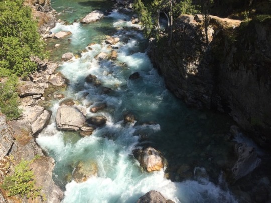
We continued onward to Lake Chalen. Chelan itself is nestled on its southernmost shore. Right here early on a transparent sunny morning we boarded the Woman of the Lake II. Vineyards and orchards dotted the hills on both facet of this slender lake. Because the boat gently chugged its approach uplake, the mountain slopes turned steeper. There have been fir bushes all over the place. Some marched soldier-like alongside the excessive ridges, some have been arbitrarily scattered on the precipitous tough terrain, others clung to life precariously near the water’s edge, and but others have been charred and blackened reminders of a devastating wild hearth. The climate modified, too. Gone was the morning’s calm azure blue water. Now small white caps danced on the lake’s metal gray floor. Threatening clouds swirled overhead. Rain was imminent.
Through the four-hour journey, the Captain offered the occasional succinct commentary. He instructed us that Chelan was the third deepest lake within the nation and, if it have been drained, it could cowl the entire of the State with 4½” of water. Afterward he identified Domke Falls the place gushing white water cascaded down the mountainside. Persevering with, he instructed us that Stehekin was a Native American phrase which means “the best way by means of”. Previously, it represented one in all few journey routes connecting the State’s inside wilderness to the North Cascades. Right now Stehekin is many issues to many individuals. It’s a mecca for backpackers mountaineering the Pacific Crest Path. For guests and residents, it’s an escape from the hustle of the trendy day world. It’s a peaceable group suspended in time the place just one paved street and one cease signal exist.
By the point we docked there have been dense clouds overhead and a gentle rain was falling. We checked into a comfortable log cabin on the North Cascades Lodge. It was time to calm down, take pleasure in a tasty lunch and decelerate. Round mid-afternoon the solar peaked by means of the clouds so we determined to walk alongside the Lakeshore Path. We handed a number of solitary cabins the place firewood had already been stacked for the winter. A carpet of pine needles lined the pathway releasing their attribute aroma. Throughout the lake have been jagged peaks rising to over 9,000 ft. Trying again, we received a peek-a-boo view of Buckner Glacier, simply one of many space’s 300 glaciers.
The following day we hopped on the “Purple Bus” for a narrated tour to picturesque Rainbow Falls the place water gushes down a 312 ft. cliff. We stood on the viewing platform the place a light-weight mist sprayed gently over us. Driver Steve instructed us that in 1897 a department of the US Put up Workplace was opened and the street was constructed by homesteaders. Mining and logging first attracted individuals to the group however quickly tourism topped the agenda. He identified “The Backyard” the place native resident Karl cultivates a big fruit and vegetable backyard and in addition raises goats and honey bees. Two miles up the street was the Pastry Firm with its giant choice of recent pastries and breads. Then tucked away within the bushes was the Previous Schoolhouse the place for over 65 years youngsters realized their ABCs earlier than it closed in 1988. These have been simply a few of Stehekin’s hidden gems. Steve instructed us that the group has no physician and that almost all medical emergencies are sorted by the park rangers. There’s a small energy station however lots of the 90 full-time residents have their very own transportable turbines. That night we visited the Stehekin Valley Ranch. Each night, a luxurious community-style meal is served. The menu included roast beef, rooster, salmon or vegetarian choices adopted by a big choice of selfmade pies. After a stimulating day within the mountain air, we hungrily wolfed all the pieces up.
The warning horn of the Woman Categorical sounded because it approached the dock. Reluctantly, we stepped aboard for the return journey to Chelan. Leaving the wharf, the boat step by step gathered velocity. For 3 days we had reveled in being off the overwhelmed monitor and had been awed by the quiet serenity of this distant paradise. Behind us Stehekin slowly pale into the gap.
Copyright © 2019 Lindsay Salt
source http://cheaprtravels.com/travelmag-a-frontier-town-in-americas-cascade-mountains/
0 notes
Text
October 12, 2018; Friday
Boy it feels like I’ve been traveling a whole lot.
Because of the holiday on Monday I ended up with a four-day weekend. Jillian and I wanted to really use as much of it as we could so we opted to attend Harvest Fest in Stehekin. I had never been to Stehekin, but it’s a difficult, remote place to get to.
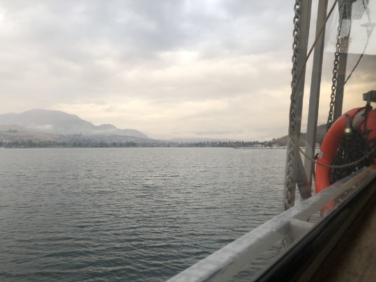
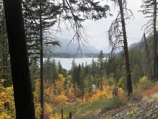
Stehekin is a town in Chelan County that is inside of the North Cascades National Park Service Complex. You can get there by either hiking in, taking a float plane, or riding the Lady of the Lake II for four hours up the 55 mile Lake Chelan. With it being October and all, Jillian and I opted for the boat.
On Friday night we drove down to a Forest Service campground called Snowberry Bowl and stayed the night there. It was a little cold that night, and difficult to get up the next morning. We woke up early so that we could get to the ferry in time for its 8:30 departure. The boat was decently sized, and because we were traveling up the lake after the height of the busy season there were plenty of empty seats on it. Jillian and I grabbed two seats on the lower deck that had their own table. For the four hour ride up she worked on some knitting and I read a book about the CIA. We also watched an episode from season two of “The Good Place.”
Upon landing in Stehekin we were greeted by two buses. One was a red bus that would drive you to and from Rainbow Falls, especially if you were just going to stay there for the 90 minute layover. The other bus was a small white one that would take you to the Stehekin Bakery and back. Quite a few people were only going to be there for the 90 minute layover. That surprised me. I had seen how much the tickets to go and back on the boat cost, and 90 minutes wasn’t a lot of time to spend there.
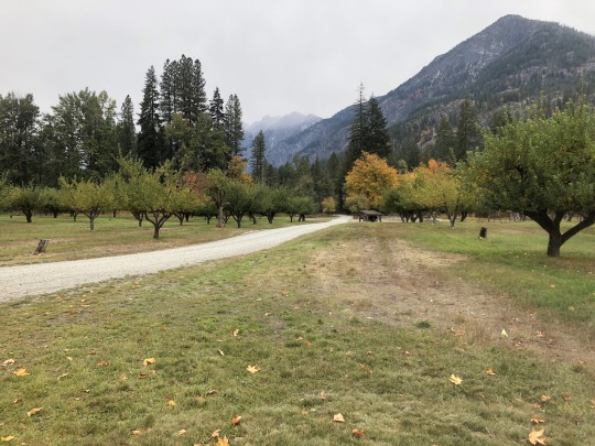
After disembarking Jillian and I grabbed a permit to stay at the Harlequin Campground, which was four and a half miles up the road from the landing. There was a red bus that served as a shuttle which would take you up the twenty-three miles of road that Stehekin has (not connected to any other roads) for a price. We opted to save $16 and hike the four and a half miles ourselves.
It turned out to be a long walk with our backpacks. The day was surprisingly warm and sunny for October in the Cascades. On the way up we got to see the Stehekin Post Office, a few houses alongside Lake Chelan, the bakery, the turnoff to Buckner Orchard where Harvest Fest was happening, Rainbow Falls, and the old and new schoolhouses. The old one was a one-room log cabin that stopped being used in 1988. We didn’t get to go inside of the new one, but it was bigger. I’m also assume that the 5 or 6 students that they do have all work in one room.
The school stuff was interesting. They do K-8 education in Stehekin. For high school the student either has to be homeschooled in Stehekin, leave the community to live and study with extended family, or the whole family has to leave for the student to be educated. Crazy stuff.
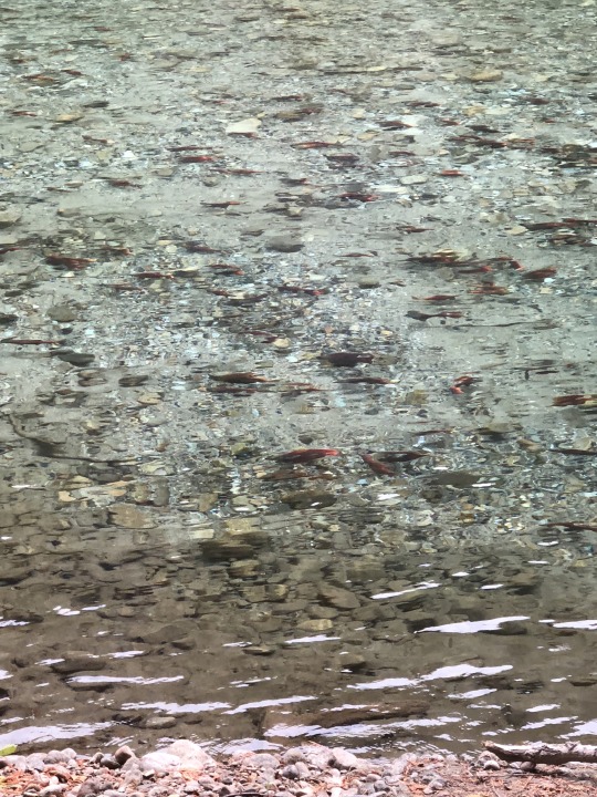
Our campground was along the banks of the Stehekin River. We were pleasantly surprised to see hundreds of landlocked sockeye salmon swimming against the current as they spawned. It was unreal seeing so many bright red fish in one place. They were our favorite thing to watch in the evenings after eating dinner. Especially when one would jump out of the water for some reason.
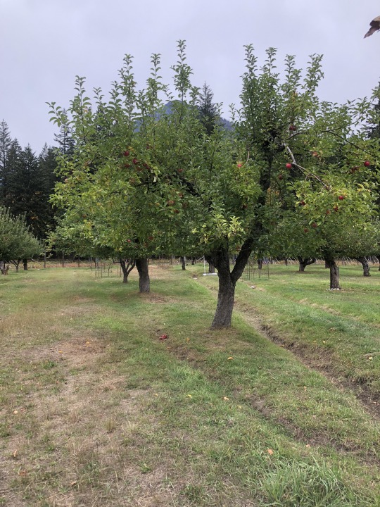
Our full day in Stehekin got off to a little bit of a disappointing start. It turns out that with less than 100 people living in Stehekin year round Harvest Fest is really only a big deal for a few hours out of the entire weekend. We had missed the big events by coming in on the boat the day that they happened. So when we walked into the Buckner Orchard we were greeted by one Stehekin family picking apples and some Park Service maintenance folks working on a cabin. We plucked a few apples from the trees, read about the historic homestead, and went on down to the bakery for lunch. The food there was very good.
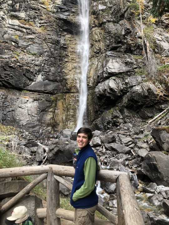
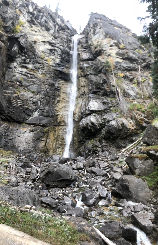
On our way back from the bakery we took a detour to visit the 312 foot tall Rainbow Falls. It was a nice place to sit and enjoy the good weather that we were having. After dinner we watched an American Dipper swim around the river near our tent.
The last day in Stehekin we opted to let the shuttle bus drive us back down to the landing where we ate lunch at the lodge and boarded the Lady of the Lake II for passage to Chelan. The sun was just starting to dip below the western horizon when we left Chelan after disembarking.
Jillian had a wedding she had to fly home to. Instead of driving from Chelan to home I drove to Sea-Tac so that Jillian could spend the entire night in the airport to catch her five am flight to Des Moines the next morning. I ended up getting home about 12:30 in the morning, took a shower, and was in bed by 1:00. That next day at work was tough.
Also tough is the fact that our car, which we are thankful to have back, is having an EVAP leak from somewhere in the fuel system. We don’t know where and the check engine light won’t go off. Very frustrating. And Subaru of America does not have very good customer service as they have blown me off every time I have brought up my problems to them.
Anyways, I’ll try and include some photos from our weekend below.


0 notes
Video

flickr
Early Morning Hours at North Cascades Lodge at Stehekin (North Cascades National Park Service Complex) by Mark Stevens
Via Flickr:
After doing some initial post-processing in Capture NX2, working to adjust contrasts and hues, I finished up by adding a Reflector Effects CEP filter to bring out an early morning look for the hours after sunrise.
#Azimuth 312#Blue Skies#Blues Skies with Clouds#Boat Dock#Boats#Bonanza Massif#Capture NX2 Edited#Cars#Cascade Range#Central North Cascades#Color Efex Pro#Day 6#Evergreen Trees#Evergreens#Hillside of Trees#Lake#Lake Chelan#Lake Chelan National Recreation Area#Landscape#Looking NW#McGregor Mountain#Methow Mountains#Mountain Peak#Mountains#Mountains in Distance#Mountains off in Distance#Mountainside#Nature#Nikon D800E#North Cascades
9 notes
·
View notes
Video
A View of Castle Rock from the North Cascades Lodge at Stehekin (Black & White, North Cascades National Park Service Complex) by Mark Stevens
Via Flickr:
A conversion to black & white with Capture NX2 where I used some color filters to bring out a much richer tonal contrast and darker skies to contrast the mountain peaks caught in the sunlight for the final image. This was captured in the Lake Chelan National Recreation area in the North Cascades National Park Service Complex.
#Azimuth 211#Black & White#Blue Skies#Bonanza Massif#Canvas#Capture NX2 Edited#Cascade Range#Castle Rock#Central North Cascades#Color Efex Pro#Day 5#Evergreen Trees#Evergreens#Hillside of Trees#Lake Chelan National Recreation Area#Landscape#Looking SW#Mountain Peak#Mountains#Mountains in Distance#Mountains off in Distance#Mountainside#Nature#Nikon D800E#North Cascades#North Cascades Lodge at Stehekin#North Cascades National Park Complex#North Cascades National Park Service Complex#Outside#Pacific Ranges
7 notes
·
View notes
Video
Pulling into the Dock at Stehekin (Lake Chelan National Recreation Area) by Mark Stevens
Via Flickr:
After a few hours of this ferry boat ride, I won't deny that it wasn't going to be nice getting back on land, exploring, hiking and even enjoying a bike ride in Lake Chelan National Recreation Area. Here one can see parked cars, vans and a red bus in front of the North Cascades Lodge at Stehekin, a place I'd be staying for the next few nights...and loving it! With some images captured I focused on the dock area, including a portion of the lodge buildings...but here I wanted the image to include that mountain backdrop added that perspective to how big they really were. I'd even enjoy a hike up a portion of that on my last morning! In the end, this image was about the boat dock but with an amazing backdrop of tall evergreens and a big mountain.
#Azimuth 271#Blue Skies#Blues Skies with Clouds#Boat Dock#Boat Ride#Boat Ride to Stehekin#Canvas#Capture NX2 Edited#Cars Parked#Cascade Range#Color Efex Pro#Day 4#Ferry Dock#Ferry Ride#Hillside of Trees#Lady of the Lake#Lake#Lake Chelan#Lake Chelan National Recreation Area#Landscape#Lodge#Methow Mountains#Mountains#Mountains in Distance#Mountains off in Distance#Nature#Nikon D800E#North Cascades#North Cascades Lodge at Stehekin#North Cascades National Park Service Complex
5 notes
·
View notes
Video

flickr
Greens of Trees on the Hillsides Surrounding the North Cascades Lodge at Stehekin by Mark Stevens
Via Flickr:
Some of the most beautiful places in this country is in our national parks...and some of those lodges...well, you get to stay there and soak in the views. That was what those days were while staying at North Cascades Lodge at Stehekin. Of course, there was a lot of exploring in Lake Chelan National Recreation Area and North Cascades National Park Service Complex too!
#Azimuth 271#Boat Dock#Boat Ride#Boat Ride to Stehekin#Capture NX2 Edited#Cascade Range#Color Efex Pro#Day 4#Ferry Dock#Ferry Ride#Hillside of Trees#Lady of the Lake#Lake#Lake Chelan#Lake Chelan National Recreation Area#Landscape#Lodge#Methow Mountains#Mountainside#Nature#Nikon D800E#North Cascades#North Cascades Lodge at Stehekin#North Cascades National Park Service Complex#Outside#Pacific Ranges#Project365#Red Bus#Rolling Hillsides#Sawtooth Ridge
1 note
·
View note
Video
flickr
A Face of a Man on a Mountainside (Black & White, North Cascades National Park Service Complex) by Mark Stevens
Via Flickr:
After capturing a few images of Castle Rock and the Moon, I found myself taking in the views while enjoying breakfast. Here I looked across Lake Chelan to this mountainside with a pattern of trees that seemed to hint at the look of a man's face with bushy eyebrows and a mustache...almost like one of the Muppets characters. I later did a conversion to black & white using Capture NX2 where I used some color filters to bring out a much richer tonal contrast for the final image.
#Azimuth 258#Black & White#Bonanza Massif#Capture NX2 Edited#Cascade Range#Central North Cascades#Color Efex Pro#Day 6#Evergreen Trees#Evergreens#Hillside of Trees#Lake Chelan National Recreation Area#Landscape#Looking West#Mountainside#Nature#Nikon D800E#North Cascades#North Cascades Lodge at Stehekin#North Cascades National Park Complex#North Cascades National Park Service Complex#Outside#Pacific Ranges#Project365#Trees#Trip to North Cascades and Washington#Lake Chelan National Recreation#Washington#United States
0 notes
Video

flickr
A View of Castle Rock from the North Cascades Lodge at Stehekin (North Cascades National Park Service Complex) by Mark Stevens
Via Flickr:
What I loved about this setting was the mountain view with the contrast of lights and shadows. Nearby on a mountainside was a forest of greens going across a ridge. Beyond that and caught in the sunlight were the jagged peaks of Castle Rock peppered with evergreen trees and snow going across the draws and folds. So if you have a chance to enjoy a breakfast at the lodge, you can have an amazing view of mountains with the early morning sunlight.
#Azimuth 210#Blue Skies#Bonanza Massif#Canvas#Capture NX2 Edited#Cascade Range#Castle Rock#Central North Cascades#Color Efex Pro#Day 5#Evergreen Trees#Evergreens#Hillside of Trees#Lake Chelan National Recreation Area#Landscape#Looking SW#Mountain Peak#Mountains#Mountains in Distance#Mountains off in Distance#Mountainside#Nature#Nikon D800E#North Cascades#North Cascades Lodge at Stehekin#North Cascades National Park Complex#North Cascades National Park Service Complex#Outside#Pacific Ranges#Portfolio
3 notes
·
View notes
Video

flickr
A Stehekin Postcard (North Cascades National Park Service) by Mark Stevens
Via Flickr:
A portrait orientation of a setting I'd captured while walking the Purple Creek Trail around the lodge area at Stehekin in the Lake Chelan National Recreation Area and North Cascades National Park Service Complex. The idea for this image was similar to a another landscape orientation image I captured where one focused on stock photos to use for postcards. For this image though, I wanted to use a portrait orientation as I've read (or my understanding is that) many magazines prefer use that style for their publications. In the end, the image is about a forest all around but a view beyond to mountains in the North Cascade mountains of Washington.
#Azimuth 310#Blue Skies#Blues Skies with Clouds#Bonanza Massif#Canvas#Capture NX2 Edited#Cascade Range#Central North Cascades#Cloud Wisps#Color Efex Pro#Day 6#Evergreen Trees#Evergreens#Hiking Imus Trail#Hillside of Trees#Ideas I Got From Others#Imus Creek Loop#Imus Trail#Lake#Lake Beyond the Trees#Lake Chelan#Lake Chelan National Recreation Area#Lake Through the Trees#Landscape#Looking NW#McGregor Mountain#Methow Mountains#Mountain Peak#Mountains#Mountains in Distance
1 note
·
View note
Video
An Image from a Faded Time (North Cascades National Park Service Complex) by Mark Stevens
Via Flickr:
Another image captured while walking around the lodge area at Stehekin. Here I used an Ink CEP filter and brought down the opacity for an older type effect as if from a postcard from years gone by. To complete the look, I added a film strip edge with Analog Efex Pro 2
#Analog Efex Pro 2#Azimuth 312#Blue Skies#Blues Skies with Clouds#Boat Dock#Boats#Bonanza Massif#Capture NX2 Edited#Cars#Cascade Range#Central North Cascades#Color Efex Pro#Day 6#Evergreen Trees#Evergreens#Hillside of Trees#Lake#Lake Chelan#Lake Chelan National Recreation Area#Landscape#Looking NW#McGregor Mountain#Methow Mountains#Mountain Peak#Mountains#Mountains in Distance#Mountains off in Distance#Mountainside#Nature#Nikon D800E
1 note
·
View note
Video

flickr
Boat Dock and Mountain View at Stehekin (North Cascades National Park Service Complex) by Mark Stevens
Via Flickr:
A view looking to the northwest while walking around the lodge area. What I wanted to capture with this view wasn't just the amazing view of mountains off in the distance, but kind of like a layered look where one would notice the nearby boat docks and then the eyes would be led further on to the lakeshore on the other side of Lake Chelan and then the mountains with the blue skies in wisps clouds above. In my mind it was the complete setting that I wanted to capture, not just the look of mountains.
#Azimuth 312#Blue Skies#Blues Skies with Clouds#Boat Dock#Boats#Bonanza Massif#Capture NX2 Edited#Cars#Cascade Range#Central North Cascades#Color Efex Pro#Day 6#Evergreen Trees#Evergreens#Hillside of Trees#Lake#Lake Chelan#Lake Chelan National Recreation Area#Landscape#Looking NW#McGregor Mountain#Methow Mountains#Mountain Peak#Mountains#Mountains in Distance#Mountains off in Distance#Mountainside#Nature#Nikon D800E#North Cascades
1 note
·
View note
Last Seen Blogs


10-josten
Formula avoiding

theunderestimator-3
THE UNDERESTIMATOR

c-sand
that's a beautiful thing to do