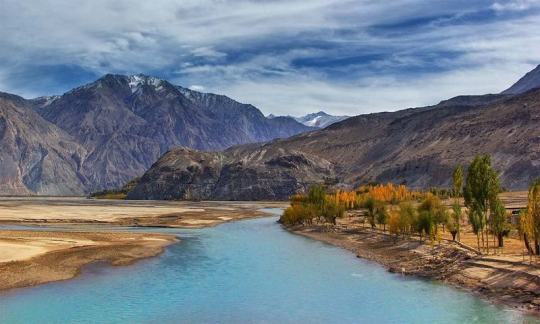
#Wakhan River
Photo

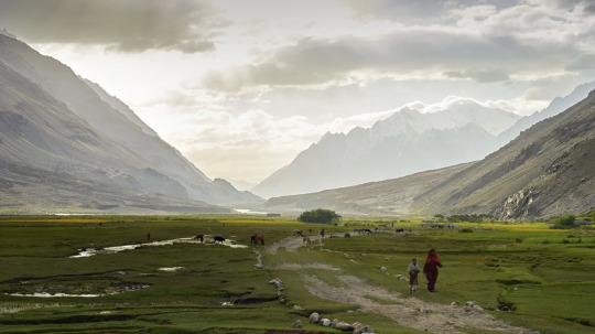
Kyrgyz women in the little Pamir.
Source: Silvia Alessi
#afghanistan#afghan#afghan people#kyrgyz#turkic#minority#asia#ethnic group#central asia#south asia#pamir#badakhshan#wakhan#wakhan corridor#rural#nature#women#veil#river#landscape#mountains#high res#asian culture#traditional clothes#nomad#nomadic
460 notes
·
View notes
Text
oh my god, philamayaye wakhan thanka for pulling me out of the river and telling me to be a dyke. i love masculine women so fucking much.
#ECHOLOCATION#i see art of butches every day and it never ceases to make me [explosion gif]#having a moment brb
2 notes
·
View notes
Text
Discover the Beauty of Afghanistan: Unveiling Group Tour Packages
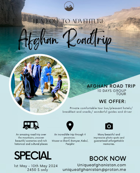
Why Choose Afghanistan for Your Next Holiday?
Afghanistan, a land of rich history and breathtaking landscapes, offers a unique and unforgettable travel experience for those seeking off-the-beaten-path adventures. From the towering peaks of the Hindu Kush mountains to the ancient cities steeped in tradition, Afghanistan is a destination like no other.
Group Tour Packages: The Perfect Way to Explore Afghanistan
Embark on a journey of discovery with our carefully curated group tour packages. Whether you're a history buff eager to explore the ruins of ancient civilizations or an adventure seeker looking to trek through rugged terrain, our tours offer something for everyone. Travel with like-minded individuals and create memories that will last a lifetime.
Unveiling the Highlights of Afghanistan Tours
Experience the vibrant culture of Afghanistan as you visit bustling bazaars, sample delicious local cuisine, and meet friendly locals eager to share their stories. Explore the UNESCO World Heritage Sites of Herat and Bamyan, marvel at the stunning beauty of Band-e Amir National Park, and immerse yourself in the history of Kabul's Old City.
Immerse Yourself in the Rich History of Afghanistan
Delve into the fascinating history of Afghanistan Tours and Holidays packages as you visit ancient fortresses, archaeological sites, and museums filled with artifacts dating back thousands of years. Walk in the footsteps of ancient civilizations and uncover the secrets of Afghanistan's storied past.
Adventure Awaits: Trekking and Outdoor Activities
For the thrill-seekers and nature lovers, Afghanistan offers a playground of outdoor activities. Trek through the rugged terrain of the Wakhan Corridor, go skiing in the mountains of Bamyan, or experience the adrenaline rush of white-water rafting on the Panj River. The possibilities are endless.
Planning Your Afghanistan Adventure
Ready to embark on the journey of a lifetime? Our group tour packages cater to all budgets and interests, ensuring that you have a seamless and unforgettable travel experience. Contact us today to book your next adventure in Afghanistan and prepare to be amazed by all that this captivating country has to offer.
0 notes
Text
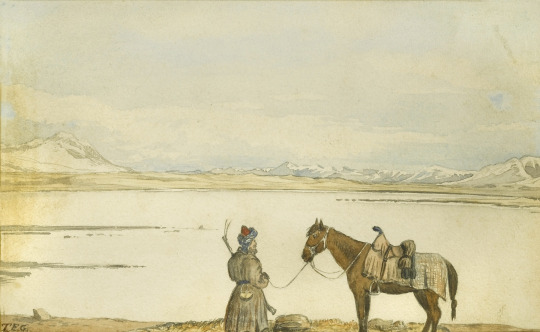
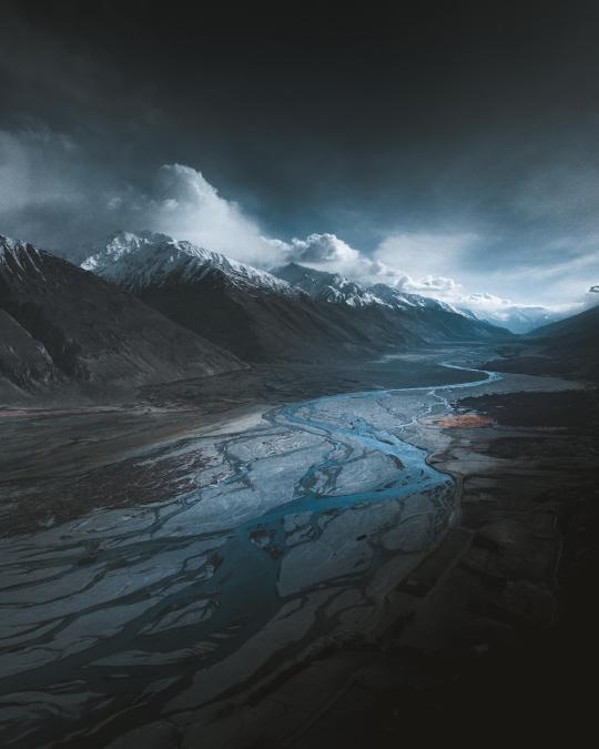
Zorkul, the Great Pamir, 1874, Thomas Edward Gordon
The Zorkul lake lies on the border between Afghanistan's Wakhan Corridor and Tajikistan's Badakhshan Mountainous Autonomous Region -- two incredibly unique locales. The Wakhan Corridor was formed in 1893 as a buffer zone to separate the British and Russian Empires. It remains a remote and beautiful part of Afghanistan, bordered by the Pamir river to the north and the Hindu Kush and Karakorum mountains to the south.
#afghanistan#wakhan corridor#pamir#hindu kush#pamir mountains#thomas edward gordon#art history#zorkul
1 note
·
View note
Text
The Hunza Valley is a mountainous valley in the northern part of the Gilgit-Baltistan region of Pakistan, formed by the Hunza River,
The Hunza Valley is a mountainous valley in the northern part of the Gilgit-Baltistan region of Pakistan, formed by the Hunza River,
The Hunza Valley is a mountainous valley in the northern part of the Gilgit-Baltistan region of Pakistan, formed by the Hunza River, bordering Ishkoman to the northwest, Shigar to the southeast, Afghanistan’s Wakhan Corridor to the north, and the Xinjiang region of China to the northeast.
The Hunza Valley is a mountainous valley in the northern part of the Gilgit-Baltistan region of Pakistan,…
View On WordPress
#a visit to hunza valley essay#about hunza valley pakistan#beautiful pictures of hunza valley pakistan#best places to visit in hunza valley#best time to visit hunza valley#government was Nagar#Hunza and Nagar#Hunza River#Hunza Valley#hunza valley activities#hunza valley attabad lake#hunza valley attractions#hunza valley beautiful pics#hunza valley best hotels#hunza valley city#hunza valley hotels#hunza valley pakistan#hunza valley people#hunza valley tourism#Hunza-Nagar Valley#pakistan hunza valley woman#Shigar Valley
0 notes
Photo

Tourist riding a yak crossing a river during a treck, Big pamir, Wakhan, Afghanistan.Taken on August 11, 2016.
PayPal Donation: [email protected]
#Eric Lafforgue#nature#landscpae#torurist#yak#river#treck#Pamir#Big Pamir#Wakhan#Wakhan Corridor#Badakhshan#Afghanistan#2016
41 notes
·
View notes
Video
afghanhistory The Wakhan is located in the extreme north-east of Afghanistan. It contains the headwaters of the Amu Darya (Oxus) River, and was an ancient corridor for travellers from the Tarim Basin to Badakshan.
Until 1883 the Wakhan included the whole valley of the Panj River and the Pamir River, as well as the upper flow of the Panj River known as the Wakhan River An 1873 agreement between UK and Russia split the Wakhan by delimiting spheres of influence for the two countries at the Panj and Pamir rivers, and an agreement between Britain and Afghanistan in 1893 confirmed the new border@Since then, the name Wakhan is now generally used to refer to the Afghan area south of the two rivers. The northern part of the historic Wakhan is now part of the Gorno-Badakhshan Autonomous Province in Afghanistan.
#Amy darya#Oxus#river#tarim basin#geology#hindu kush#pamir river#nature#landscape#Panj river#panorama#video#mountains#snot#travel#wakhan#the earth story#instagram
50 notes
·
View notes
Text
IN PICTURES | REMOTE PLACES | AFGHANISTAN
A New Road To An Inaccessible Land

— By Simon Urwin | 2nd July 2021
Once an isolated region barely touched by the hands of time, Afghanistan's Wakhan Corridor stands on the brink of great change with the building of a new road linking it with China.

On the Cusp of Six Borders
Bordered by China, Iran, Pakistan, Tajikistan, Turkmenistan and Uzbekistan, the Islamic Republic of Afghanistan lies at the very heart of Asia. Home to more than 32 million people, a quarter of its population lives in large urban centres such as Mazar-e Sharif (pictured), located 320km north-west of the capital Kabul. The fourth-largest city in the country, its centrepiece is the Shrine of Hazrit Ali – a masterpiece of Islamic architecture, which, according to local legend, is the burial place of Ali, the cousin and son-in-law of the Prophet Muhammad. The shrine is also renowned for its flocks of white doves. Locals believe that a small speck of another colour on a bird's feathers will instantly turn pure white when in the sacred building's vicinity. (Credit: Simon Urwin)
A Remote Corridor
Some 600km to the east of Mazar-e Sharif, the Wakhan Corridor (pictured) is a world apart from the rest of the country, both culturally and geographically. This 350km-long panhandle, in the region of Badakhshan, sits at the convergence of three of the world's major mountain ranges: the Hindu Kush, the Karakoram and the Pamirs – known as the Pamir Knot. "This is about as far away from the noise, the traffic and the muezzin's call to prayer of urban Afghanistan as you can get," said James Willcox of untamedborders.com, one of just a few adventure travel companies in the world that arranges trips to the region. "It is barely habited and hard to get to; few people even know of its existence. It's undoubtedly one of the remotest, and most beautiful places in the whole of Asia." (Credit: Simon Urwin)
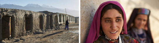
A Rural Life
Scattered along the Wakhan Corridor are small rural settlements like Khandud (pictured), their simple houses made of stone, mud and timber. Some of the larger villages are connected by a single dirt track, often made impassible by the waters of the River Panj. "Very few people have their own car in the Wakhan, but we have community transport – as well as donkeys, and our feet, of course," said Azim Ziahee, a resident of the market town of Ishkashim, located 80km away at the Corridor's western end. "The Wakhan still remains very cut-off though. Some villages are more than four days' walk to Ishkashim. The nearest big town from here – Dushanbe, the capital of Tajikistan – is a three-day drive. The isolation keeps the corridor like a time capsule. We look over to the border towards Tajikistan, with its electricity, paved roads and mobile phone signal, and say that it's like looking 100 years into the future." (Credit: Simon Urwin)
Home of the Wakhi
For more than 2,500 years, the Wakhan Corridor has been the homeland of the Wakhi people and is now home to a population of around 12,000. While the majority of Afghans are conservative Sunni Muslims, the Wakhi are Ismailis, who belong to the Shia branch of Islam. Here, women do not wear the burqa, and there are no mosques; instead, the Wakhi visit jamatkhanas (houses of prayer that also serve as community halls for conducting village business). "Ismailis are considered less strict than Sunnis," said Willcox. "For example, in the Wakhan, a Western male visitor can ask permission to take a woman's photograph without causing offence. Elsewhere in Afghanistan that would be unthinkable. (Credit: Simon Urwin)

The Rhythm of Life
The Wakhi are farmers, cultivating wheat, barley, peas, potatoes, and apple and apricot trees in the semi-arid conditions of the corridor; their fields fed by melt water from mountain glaciers. Wealthier families have sheep and goats along with a few camels, yaks, horses and donkeys. "Every June, the Wakhi take their livestock to summer pastures, up as high as 4,500m, where the animals grow fat on the rich grass," said Ziahee. "The migration is called the 'kuch'. We also have the 'Chinir', which is our festival in early August to celebrate the start of the barley harvest. In the towns of Afghanistan, the five daily prayers form the structure of the day, but here, we feel a great connection to the land, and whilst we pray daily, the rhythm of life revolves more around the fields, the seasons and nature." (Credit: Simon Urwin)
A Centuries-old Tradition
One of the most distinctive traditions of the Wakhan is the centuries-old game of buzkhasi, sometimes described as rugby on horseback with the body of a goat as a ball. Thought to be an early pre-cursor to polo, buzkashi has no rules and no sides. There is certainly no sense of "fair play", as competitors will punch and whip each other in an effort to steal the goat, and broken bones are not uncommon. "The Wakhi villages love to play each other, especially at Nawruz, which is the Afghan New Year," Ziahee explained. "But here it's different to other parts of Afghanistan. Elsewhere, buzkashi is more political – put on to show the power of the elite, or by a politician as a way to win votes. Here, it is all about the competition and the community. It is one of many things that makes the Wakhan so unique." (Credit: Simon Urwin)
Untouched By Tourism
While Afghanistan's security situation dictates that much of the country is off-limits to foreigners, the corridor's relative safety, alongside its pristine mountain scenery and well-preserved Wakhi culture, has seen its appeal with off-the-beaten-trackers grow markedly in recent years. "At first there were only a handful of visitors," said Ade Summers, an adventure guide who has led nine expeditions to the Wakhan. "Over a decade, that's slowly grown to up to 600 people a year. It's a privilege to visit somewhere so untouched by mainstream tourism, where you can engage with people who still relish their traditional way of life. As you journey along the Wakhan, not only is it very beautiful, every step you take is like turning the pages of a fascinating history book." (Credit: Simon Urwin)

Part of the Silk Road
For hundreds of years, the Wakhan Corridor was an important route for merchants travelling along the Silk Road, the trade route that emerged in the 1st and 2nd Centuries BCE linking China with the Mediterranean. "Those merchants carried Chinese silk, Persian silver, Roman gold and Afghan lapis lazuli, mined here in the Badakhshan region," said Summers. "We find rock art detailing the road's history, such as petroglyphs of camels walking in single file as a trade caravan." Travellers and pilgrims followed in the merchants' footsteps. "Marco Polo is said to have passed through here on his way to China in the 13th Century, also Alexander the Great. We can still see the remains of historic travellers' shelters known as rabats, as well as ancient Buddhist stupas." (Credit: Simon Urwin)
A Strategic Place
In the late 19th Century, the Wakhan Corridor played a key role in the so-called "Great Game" between Great Britain and Russia. "When the Russians and the British were fighting for control of Central Asia, Afghanistan was hugely strategic,", said Willcox. "The Wakhan's current boundaries were formed in 1893 to create a buffer zone to prevent both parties' territories from touching each other – in this case, the British Raj and the Tsarist Russian empire. It eventually turned an old trade route into a cul-de-sac. More recent, history has seen the Wakhan caught up in the Cold War; and now the latest changes in geopolitics will have perhaps an unexpected consequence, with China's Belt and Road Initiative turning it into an important trade route once again." (Credit: Simon Urwin)

New Construction
Until recently, the dirt track from Ishkashim reached only as far as Sarhad-e Broghil in the centre of the Corridor. Onward travel east was only possible by foot or with pack animals. Now though, with Belt and Road construction, the track has been extended by some 75km, as far as the village of Bozai Gumbaz, around three quarters of the way along the Wakhan. "It follows an old trading route that the Kyrgyz nomads take to get to Sarhad from where they live around Chaqmaqtin Lake," said Summers. "The bulldozers have come in, and while they've only constructed something the size of a farmer's track, the potential consequences are much bigger. The Chinese are said to be building the stretch that will eventually connect their border with Bozai Gumbaz, something that will open up the cul-de-sac once more. Ultimately, it will give China great access to the markets of Central Asia and beyond." (Credit: Simon Urwin)

Mixed Emotions
Ziahee says that the people of the Wakhan have mixed feelings about the road's potential impact. "Some things will be good for us," he said. "We will be able to buy goats from China which will be much cheaper than from the market in Ishkashim. We hope to have access to better healthcare, too. At the moment, many of our facilities are very limited. But we worry that the unique Wakhi culture and slow way of life will be changed forever. We love the silence and beautiful nature, but fear that it will be destroyed by traffic pollution. Building a road takes a long time in the mountains, but we think in the next year or so it will be completed. Both the Chinese and Afghan governments want it to happen. Only time will tell what the future holds for us as a result." (Credit: Simon Urwin)
5 notes
·
View notes
Link
The next day of hiking seemed to drag on forever. There wasn’t any particular reason for that, Jason thought. It just did.
He had grown to hate the trail mix in the bag. And the lamb jerky. And the meal bars.
Everything they had to eat was disgusting and Jason was sick of it all.
He could tell the kids were growing tired of it, as well.
At least none of them had voiced their complaints… It’s not like he could do anything about it.
But it was relieving to know that tomorrow they’d reach a town with a store. And an inn. And a restaurant.
If it had that many businesses, Jason was sure it saw enough travelers that they could blend in fairly easily. They’d just claim to be tourists. Hiking around for fun. Meeting back up with parents, they could say, if someone called him out for being too young to be responsible for the brats.
The only downside was they’d finally exited the Wakhan Corridor, which meant they no longer had the river to help them along. They actually had to follow GPS, now.
Or, at least, that’s what Jason let Damian believe. He knew they needed to head almost precisely southwest, so it wasn’t very difficult to do without the aid. But it kept Damian busy. So whatever.
The brats were fairly quiet over all, which was nice. But Jason supposed he gave them a lot to think about the night before.
He still wasn’t sure what the answer to their problem was.
He could always just take them to some random ass city and try to blend in there. Hide the kids from Ra’s.
Jason almost laughed.
There was no way in fuck he was doing that.
Continue reading on Ao3
#Jason Todd#Damian Wayne#athanasia al ghul#mara al ghul#jason and the three terrors#batman#red hood#batgirl#batfamily#robin#fanfiction
57 notes
·
View notes
Photo

Labour The early morning sound of the rattling pike grabbed us from the dreams we would share to each other while sipping tea. Keeping the room warm by -20°C outside involves small but steady acts of care. The routine was settled and timed by women activities inside: the main room regularly cleaned, dung brought to the stove, water collected at the frozen river, rice washed and cooked, tea warmed, milk skimmed, added and poured into our cups, bread loaves in the center, butter or cream aside, the tablecloth swiftly opened ahead our knees touching each other. Do not forget an eye for the toddler and the young girl besides. Men would then move outside. Yack, sheep and goats out of the corrals, walking together to the pastures where they would spend lonely hours. Children opened the Koran and school booklets with elders, sitting for the day, playing outside during warmers hours. Evening we enjoyed the visit of neighbors, watching Turkish series and the news on TV. #labour #Afghanistan #Wakhan #LittlePamir #everyday #writing #ethnography #women #centralasia (at Vakhan, Afghanistan) https://www.instagram.com/p/CE0xQ5Yhcan/?igshid=oh1qfeulg9i7
2 notes
·
View notes
Photo
In the Wakhan Corridor, early morning light illuminates the Panj River, the natural border between Afghanistan and Tajikistan. [2992x3740][OC][IG @ Ahpflaum] Check this blog!
11 notes
·
View notes
Photo

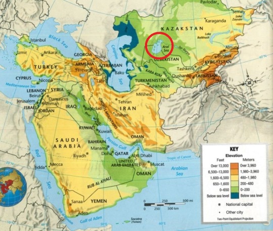
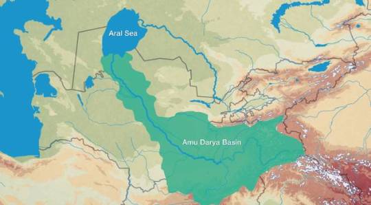
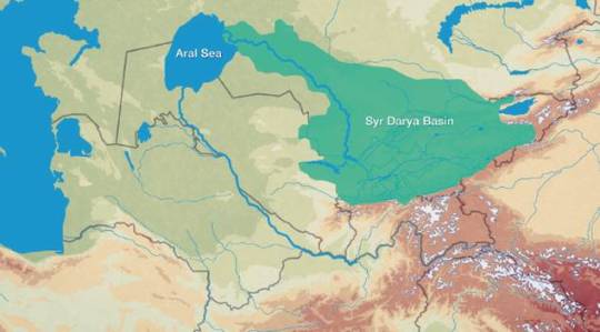
The drying and disappearance of the Aral Sea
Up until the mid-20th century, the Aral Sea was still the planet’s 4th-largest lake or inland body of water. It was about the same size as Lake Victoria; 18% larger than Lake Michigan and Lake Huron; and only significantly outsized by the Caspian Sea and Lake Superior.
On this map from NASA Earth Observatory, that visible black outline represents the shore/size of the lake around 1965.
Much of the water from the Amu Darya and Syr Darya rivers, which feed the lake, has been diverted for agricultural irrigation, since the region east of the Aral Sea and between the two river corridors is dominated by the harsh and arid Kyzylkum desert.
-
Another view, from NASA (collage by Wikimedia user Producercunnigham; labels added by me).
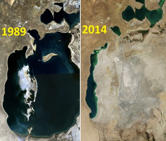
On left, the Aral Sea in 1989. On right, 2014.
In 1960, the surface area of the Aral Sea was still about 68,000 square kilometers in size. By 2004, the size had been reduced to 17,000 square km, separated into 4 detached remnant lakes. By 2008, the Aral Sea was only about 4,000-5,000 square km.
-
Location of the Aral Sea.
-
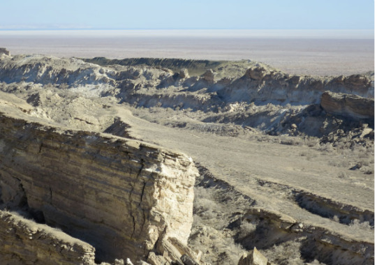
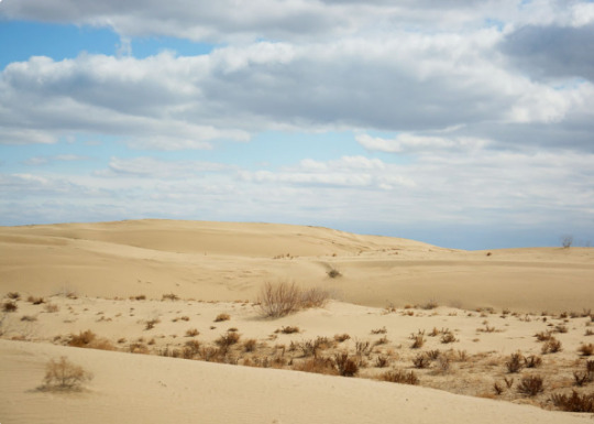
The Aral Sea sits amidst the true deserts and semi-desert/semi-arid drylands of Central Asia. Here is the Utstyurt, a desert plateau along the southern and western edges of the Aral Sea. [Source.]
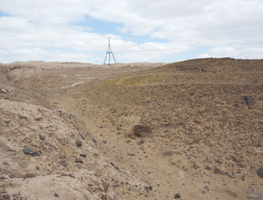
And here is Aralkum, the desert along the dry lake bottom of what used to be the eastern portion of the Aral Sea. [Source.]
Since most of the landscape in Turkmenistan, Uzbekistan, and eastern Perisa/Iran is either true desert or semi-arid steppe, the Amu Darya and Syr Darya rivers are an important source of water for irrigation, allowing for relatively fertile corridors of human settlement in the otherwise dry region. The two rivers collect the runoff and glacial meltwater from the immense and dramatic Pamir Mountains of Tajikistan and Kyrgyzstan. The removal of water from these two rivers, largely for agriculture, has led to the disappearance of the Aral Sea’s eastern basin.
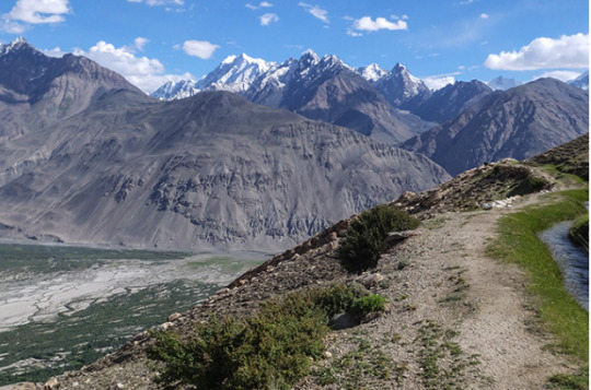
Wakhan Valley, in the Pamir mountains of Tajikistan. [Source.]
[Map source.]
Between the two rivers sits the Kyzylkum desert, much of which contains huge sand dunes and sand massifs. Here’s a look at the region. [Source.]
Anyone with an interest in Persian, Khwarazmian, or Central Asian history or culture will be familiar with the significance of the Amu and Syr Darya riparian corridors as very important locations of fertile soil; agriculture; settlement; and cultural history.

The Syr Darya. [Source.]
And here is the Khwarazm oasis, which sits at the southern shore of the Aral Sea where the Amu Darya river used to enter the lake. [Source.]

In the past few thousand years, there were various communities of Persian and Turkic peoples known as the “Khwarazmian” or “Kohrezmian” oeople who lived along the Amu Darya. At times, they were closely allied with the Persian state, exchanging arts and culture.
Until the early-20th century, the Caspian tiger (Panthera tigris virgata), a now-extinct subspecies of tiger, used to live along the shores of the Amu and Syr Darya, using the riparian habitat corridors to extend their distribution into the dry landscapes of Central Asia. After significant crops were planted along the rivers, the tiger generally disappeared by about the 1960s, being formally declared extinct in 2003.
A distribution map of known Caspian tiger habitat and sightings. [Source.]
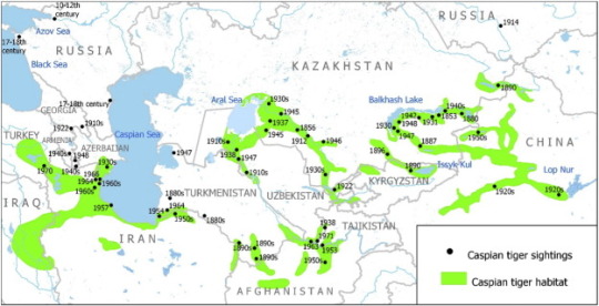
A Caspian tiger from the Caucasus, at the Berlin Zoo in 1899.

(I guess you could say that the Caspian tiger is sort of like a symbol of what was lost, as the fertile river corridors of Central Asia were developed for industry and agriculture, leaving modern Central Asia with less vegetation and more deserts.)
69 notes
·
View notes
Photo

In the Wakhan Corridor, early morning light illuminates the Panj River, the natural border between Afghanistan and Tajikistan. [2992x3740][OC][IG @ Ahpflaum]
3 notes
·
View notes
Photo

In the Wakhan Corridor, early morning light illuminates the Panj River, the natural border between Afghanistan and Tajikistan. [2992x3740][OC][IG @ Ahpflaum]
2 notes
·
View notes
Photo

In the Wakhan Corridor, early morning light illuminates the Panj River, the natural border between Afghanistan and Tajikistan. [2992x3740][OC][IG @ Ahpflaum] via /r/EarthPorn https://www.reddit.com/r/EarthPorn/comments/fe3g0r/in_the_wakhan_corridor_early_morning_light/?utm_source=ifttt
1 note
·
View note
Text
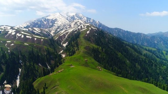
PLACES THAT YOU MUST VISIT IN PAKISTAN
When you come to Pakistan, the country is blessed with exceptional and mesmeric landscapes, beautiful rivers, huge and wide desserts, calm lakes, tranquil waterfalls, exotic, huge and calm icy glaciers, and a few exciting awing sceneries. There's no doubt Pakistan the country is holy with each face and style of natural beauty.
Place 1: Chitral
When talking regarding the foremost favorite holidaymaker destination in an Asian country, Chitral continually tops the charts. At Chitral, there are several choices to explore like Tirich Mir; that is one in all the best mountain peaks within the range chain. There are many majestic mountains and lush inexperienced meadows that solely defines the spectacular landscape of Chitral valley.

There are several hotels and resorts within the valley that are giving mesmeric views of the geological formation. Garam Chashma could be a spot wherever each holidaymaker enjoys the foremost. The universal truth is that the water from Chashma is often cold however what makes Garam Chashma unbelievable is that it's a fountain that has miraculous healing properties in it moreover. Barmoghlasht could be a well-known resort in Chitral. within the summers, sightseers love paragliding whereas in winters they like sport. the 2 spots particularly Koghazi and Goleen have remarked as paradise on Earth thanks to their large beauty. These locations are simply fourteen kilometers far away from Chitral.
You can find several trees that are bearing fresh fruits, unbelievably amazing inexperienced meadows and exceptional landscapes in Chitral that creates it a prime priority once it involves traveling to northern areas of an Asian country.
if you are in Pakistan and you visit the Lahore city and face some problem related living place when you visit this link and I fix your problem for you houses for sale in DHA Lahore
Place 2: Neelum Valley
Nearly 240 kilometers long, the picturesque and scenic Neelum valley is placed at the north and also the northeast aspect of Muzaffarabad. It runs parallel to the attractive Kaghan valley that goes up to the Kel. it's separated from Kaghan depression by snowy peaks and blue water.

Neelum Valley could be a good spot for trekking with friends and family. The Ratti Gali Lake in Dowarian is not simply a hypnotic lake, however the engaging and quaint piece of heaven. Jagran Nallah is an exotic and entrancing place that joins Neelum valley and permits trout fishing. There are Kundal Shahi and Kutton that's one hundred fifty-five kilometers and sixteen kilometers far away from Neelum watercourse, that is additionally fascinating to go to.
At Neelum valley, the tourist's witnesses superb scenic beauty, exclusive perspective, on each side of the watercourse there are high hills, lush inexperienced flourishing forest, high altitude huge lakes and attractive surroundings that create the dream of beauty truth.
Spot 3: Hunza
A mountainous valley within the neighborhood of Gilgit is a neighborhood currently underneath Pakistan named as Hunza. it's the foremost notable traveler destination simply because of its classic beauty and natural beauty. it's normally called if there is any heaven on Earth than Hunza depression is that
The Hunza valley is amid range and also the range that's nearly a hundred klick from Gilgit. There are several beautiful spots to go to in Hunza like the historic Baltit Fort that's within the United Nations agency world heritage tentative list. The Borith Lake has some spectacular read, specifically in winter season once several ducks, moreover because the birds, migrate from different heat regions of Asian nation. there's the second highest peak within the world, K-2 that is ideal for trekking expeditions.
if you want to buy some property in Lahore then you must visit this site that is one of the most preferred choices for the people who are in search for a house for sale in DHA Lahore
Hunza is additionally notable for its beautiful eateries that provide the normal Sharbat, diram-fete, muleda, dildo and lots of different exotic ones. Hunza isn't simply stunning to travel and revel in the heavenly beauty however conjointly attractive to go to with favorite ones. it's a favorite spot particularly for new married couples to get pleasure from their golden amount of married life within the heat of incommensurable nature’s beauty.
Spot 4: Swat
Swat is that the district within the Malakand Division of the Khyber Pakhtunkhwa province. it's celebrated for its exceptional natural beauty and scenic landscapes. In 2007 the land of pure beauty was condemned by the Taliban and therefore the district lost its tourists importance. when the war against the act of terrorism in Swat by the military commandos in 2009, the land got free from criminal occupants and once more opened for tourists everywhere the planet.

There are several reasons to go to Swat once you come back to the Asian country. It offers astonishing views of the stream of Swat, ennobling Malamjabba resort hotel, Mingora, Kalam, Saidu Sharif, and Bahrain. All those tourists who are history aficionado than Swat could be a good spot with nice historic and fine arts worth. there's a recreational space named Fizagat Park that's not simply lovely however additionally has exciting views. Marghazar that's simply a number of miles off from Saidu Sharif could be a gorgeous white marble palace additionally called Sufed Mahal.
The celebrated Malala Yousafzai was additionally from the attractive valley of Swat. Swat holds utmost beauty awarded by Almighty and it's an ideal spot to get pleasure from some unforgettable moments with friends, family and your lover.
Spot 5: Kaghan Valley
A beautiful valley that's forever able to forge a wizardly spell on its spectators, Kaghan valley is an alpine-climate valley that's found within the district of Mansehra in KP (Khyber Pakhtunkhwa) province of West Pakistan. The mesmeric natural depression extends to just about a hundred and fifty-five kilometers beside a beautiful pine forest, tremendous mountain streams, and luxurious inexperienced meadows, creating it an awesome spot for tourists from everywhere in the country.

Naran and Balakot is a part of this glorious valley. Through Kaghan valley, Kunhar stream flows adding additional splendor and magnificence to the scenic space. Tourists visiting Kaghan valley can never miss the chance to ascertain Lake Saif-ul-Mulook that's a fascinating lake enclosed by verdure never seen before. The pointed peak, Malika Parbat may be seen as a mirrored image within the lovely crystal clear lake. A quaint inexperienced pasture named as Lalazar has thick dark forests of pine and fir with wildflowers growing everywhere the mountain slopes. House For Sale in DHA Lahore
Kaghan Valley could be a paradise that came on Earth. It offers splendid scenic views and beautiful landscapes that are beautiful to observe. The far-famed Jheel Saif-ul-Mulook and therefore the Lalazar is a number of the foremost picturesque places of West Pakistan to go to, particularly at the time of spring.
Spot 6: Gilgit Baltistan
The northern territory of West Pakistan is thought as Gilgit and Baltistan that is enclosed by marvelous and majestic tall mountain peaks. It borders with Azad Kashmir to the south, whereas borders Khyber Pakhtunkhwa to the west, Wakhan the passageway of Afghanistan to the aspect|side} and state region of China to the eastern side. it's stunning simply the method {kashmir|Kashmir|Cashmere|Jammu, and kashmir|geographical area|geographic area|geographical region|geographic region} is; as Kashmir is actually an area which may be compared to the wonder of Heaven higher than the sky.

The incomparable celebrated Yasin natural depression, Naltar and mountain peak are a part of} wonderful Gilgit and Baltistan and are part of the bucket list of each tourer visiting the place. This region as called in a veryll|one amongst|one in every of} the attractive places of West Pakistan that are not simply stunning however once you are there you are feeling like being in a paradise of solitude and eternal beauty. The inexperienced meadows are found at the bottom of Nanga Parbat and for hiking the durable Nanga Parbat, the tourist takes around four to five hours of continuous hiking to achieve the highest of it.
Spot 7: Rawlakot
The capital of Poonch district in Azad Cashmere, Rawalakot could be a lovely spot for tourists everywhere on the planet. it's additionally stated as ‘Valley of Pearls’ as a result of within the summers the almond trees blossom giving an overall impression of pearls being scattered on the bottom.

A noted peak space of Rawalakot is Tolipir that is at a pair of hours’ drive from Rawalakot. For honeymoon tours, this pristine beauty place in conjunction with hypnotic landscapes builds it a perfect spot for young couples.
Spot 8: Shogran And Siri Paye
Shogran and Siri PAYE are 2 tourists spots settled within the Kaghan valley, that are somewhat underrated as compared to different places in West Pakistan. Shogran maybe a hill station that has lots of resorts likewise as hotels for accommodation of the tourists. Whereas, Siri PAYE may be a high mountain lake encircled by undulating clouds, nearly eight kilometers far from Shogran.
Both these places don't seem to be simply stunning however conjointly offers exotic landscapes, lush inexperienced grassland, and picture scenic read to treasure each moment of life with delight and happiness. House For Sale in DHA Lahore
This is the list of most stunning places that as a tourer you have to be compelled to visit. Update your bucket list directly expertise|and knowledge|and skill} the heavenly experience right Earth in West Pakistan. At ilaan.com we tend to carry on posting tourists guide for you to understand a lot of regarding exceptional places everywhere West Pakistan. keep tuned for contemporary updates.
1 note
·
View note
Last Seen Blogs

crystaestrad-blog
Untitled

herky24
LETS PLAY!

wontcumagain
Wontcumagain

deploreble
DRAW A MONSTER.

teaodore
#blacklivesmatter