#indigenous lands
Text
Happy long weekend, y'all.
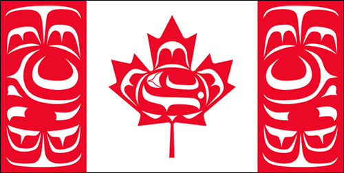
I refuse to celebrate Canada Day when Indigenous people are still facing genocide.
#canada day#long weekend#indigenous issues#the real life of me#canada#i'm just saying#indigenous lives matter#indigenous lands
34 notes
·
View notes
Link
5 notes
·
View notes
Text
On this day we must honour the treaties , acknowledge the heartbreak and trauma we’ve caused by creating a second class Canadian and demand change
#indiginous#indigenous lives matter#indigenous lands#canada government#canada day#canada#injustice#racisim
2 notes
·
View notes
Text
please do not ever forget that the “americas” are stolen land. that we survive despite genocide. that we still exist despite continuing colonialism. solidarity with indigenous people around the world.
14K notes
·
View notes
Text
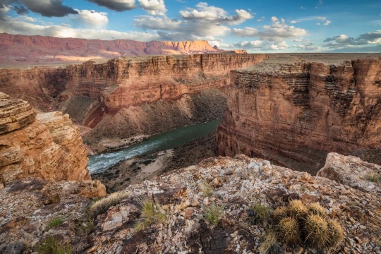
This New Park Gives Different Views of the Grand Canyon—with No Crowds
These sacred Indigenous lands in Arizona just got government protection. Here’s how to explore their hikes, wildlife, and impressive vistas.
— By Joe Yogerst | September 1, 2023

Red Butte, which the Havasupai people call Wii'i Gdwiisa (“Clenched Fist Mountain”), is one of many sacred Indigenous sites within Arizona’s new Baaj Nwaavjo I’tah Kukveni Grand Canyon National Monument. Named a national monument by President Joseph Biden in August 2023, the one-million-acre wilderness offers hiking, backcountry camping, and views of the Grand Canyon without the crowds. Photograph By Taylor McKinnon, Center For Biological Diversity
Grand Canyon National Park draws 4.7 million visitors a year to the northwest corner of Arizona to hike, camp, or watch wildlife. But most of them don’t realize that the lands within and surrounding the park are sacred to the region’s 12 Indigenous tribes, which include the Havasupai, Hopi, Navajo, and several bands of Paiute.
That changed on August 8 when President Joseph Biden signed a decree creating the Baaj Nwaavjo I’tah Kukveni—Ancestral Footprints of the Grand Canyon National Monument. Sprawling across more than 960,000 acres directly north and south of the national park, the new monument offers more rugged, less crowded recreation than its neighbor. It also provides a view of the landscape through Indigenous eyes.
“Baaj nwaavjo in Havasupai means ‘where the ancient people roamed,’” says Carletta Tilousi, coordinator of the Grand Canyon Tribal Coalition. “I’tah kukveni is the Hopi translation of ‘ancestral footsteps’. This reaffirms their creation stories.”
Here’s how the monument came to be, and how to explore it.
Baaj Nwaavjo I’tah Kukveni yields views of the Colorado River and Grand Canyon from a different perspective. Photograph By Amy S. Martin
How to Make a National Monument
It took two million years for the Grand Canyon itself to form and around 40 years for Baaj Nwaavjo I’tah Kukveni to become reality. “The protection for these lands is something the tribes have focused on since as far back as the 1980s,” says Amber Reimondo of the Grand Canyon Trust, a nonprofit devoted to preserving the region.
Many of these Indigenous people were expelled from their territory when Grand Canyon National Park was established in 1919. They campaigned for decades to receive stronger protection for their lands around the park, overcoming entities that wanted fewer legal obstacles to development and mining. After President Biden’s election in 2020, the 12 tribes formed a coalition which led to the lands receiving federal status.
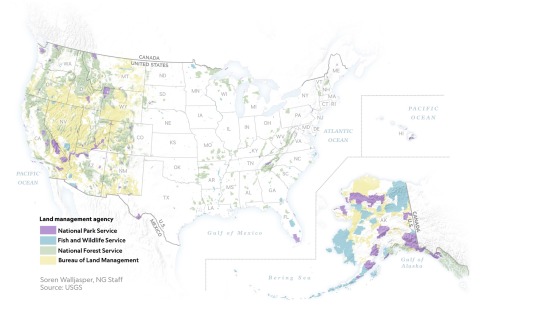
Though the National Park Service oversees Grand Canyon National Park, monuments such as Baaj Nwaavjo I’tah Kukveni are run by the U.S. Forest Service (USFS) and the Bureau of Land Management (BLM). Monuments generally have fewer restrictions regarding their use (e.g., sometimes hunting or logging is allowed), as well as fewer facilities for visitors.
Fewer Amenities, Fewer Crowds
Like many national monuments, Baaj Nwaavjo I’tah Kukveni exudes raw nature. It has no bathrooms or visitor center; access is primarily via dirt roads or rough trails; you’ll need a four-wheel-drive to reach many sections of the park.
What it offers is solitude and peace amid the forests and grasslands of northern Arizona. You can gaze at the Grand Canyon without thousands of other people jostling for the same space, hike trails where yours are the only footsteps, and make camp at secluded spots. Plus you might encounter wildlife such as elk, black bear, mule deer, birds, or bison.
That solitude is also important to the Indigenous people. Tilousi says that when she visits the busy South Rim inside Grand Canyon National Park, “It’s very difficult for me to find a spot where I can offer prayers and offerings in a quiet way.” She feels that won’t be an issue in the off-the-beaten-track lands of the new monument.

Native plants including yucca flourish within Baaj Nwaavjo I'teh Kukveni National Monument. Photograph By Amy S. Martin
Exploring the Monument
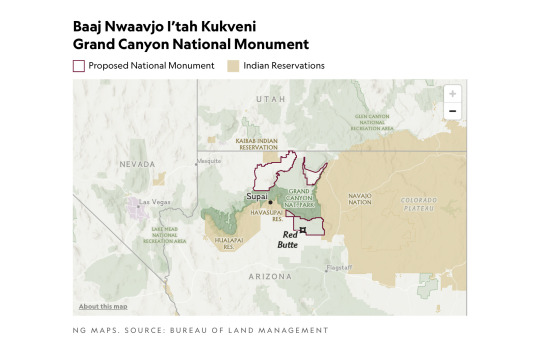
The vast wilderness of Baaj Nwaavjo I’tah Kukveni is divided into three distinct sections or parcels, each with its own appeal.
The southernmost section, the Tusayan Ranger District/South Parcel, is the easiest to explore. Comprising 330,000 acres within the Kaibab National Forest, its pine woodlands and sagebrush prairie are accessible via Forest Service roads or Sections 35 through 37 of the Arizona Trail, an 800-mile hiking route stretching across the entire state.
The South Parcel also shows signs of human life, including the rusty hangar of the 1920s Red Butte Airfield and the 80-foot-tall Grandview Lookout Tower, which you can climb for views of the Colorado Plateau and the Grand Canyon.
The other sections of the monument, Kanab Plateau/Northwest Parcel and Rock House Valley/Northeast Parcel, are located beyond the North Rim section of Grand Canyon National Park.
“It's a big, remote wilderness,” says Michael Cravens, advocacy and conservation director of the Arizona Wildlife Federation. “I’ve never in my life been somewhere with night skies that spectacular.” But he cautions visitors “to be careful and prepared” for the extreme weather and topography. You can reach the northern parcels on BLM roads south of U.S. Highway 89A.

The vast House Rock Valley stretches through a portion of the new national monument. Photograph By Taylor McKinnon, Center For Biological Diversity
Stretched across the Kanab Plateau and Antelope Valley, the Kanab Plateau section has hiking routes through spectacular side canyons and to panoramic views such as Gunsight Point.
The Hack Trail drops down into the Kanab Creek Wilderness with its enormous red-rock canyons, a landscape almost as impressive as the Grand Canyon itself. Experienced hikers can continue down Kanab Creek to the Colorado River or along other trails to vertiginous overlooks along the North Rim.
Set beneath the Vermilion Cliffs National Monument, the Rock House Valley section of Baaj Nwaavjo I’tah Kukveni tumbles across sagebrush flats to the edge of Marble Canyon. Rugged hiking trails here include the Soap Creek Trail, which winds down from the Rapids/Badger Camp Overlook to a primitive campsite near the river.
Rough roads lead south to viewpoints for Rider Canyon, South Canyon, and other offshoots of the Grand Canyon. Here, you might even spot the North Rim’s resident bison herd, brought to the Arizona Strip in 1906 by Charles “Buffalo” Jones as part of efforts to save the species.
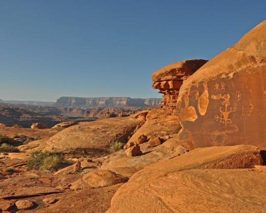
Ancient rock art can be spotted in the Kanab Creek Wilderness portion of Baaj Nwaavjo I’tah Kukveni National Monument. Photograph By Natpar Collection, Alamy Stock Photo

The Havasupai Indian Reservation in Arizona, which includes the Havasu Waterfall—part of the Havasupai Falls—is the current home of the Havasupai people. After the Grand Canyon became a national park, they were forcibly removed from their traditional homelands in the canyon and in nearby lands that will be part of the new national monument. Photograph By Mike Theiss National Geographic Image Collection
1 Million Acres of ‘Sacred’ Land Near Grand Canyon are Receiving New Protections! The designation of the land as a national monument, confirmed to National Geographic this week by the White House, will prevent new uranium mines and protect historically significant tribal lands.
#United States 🇺🇸 National Parks#New Park#Grand Canyan#Indigenous Lands#Arizona#Wildlife#Red Butte | Clenched Fist Mountain#Arizona | Baaj Nwaavjo I’tah Kukveni Grand Canyon National Monument#Center For Biological Diversity#President Joe Biden#Carletta Tilousi | Coordinator | Grand Canyon Tribal Coalition#Ancestral Footprints#Colorado River#Amber Reimondo | Grand Canyon Trust | Non-profit | Region Preservation#National Park Service#U.S. Forest Service (USFS) | The Bureau of Land Management (BLM).#Wildlife | Elk | Black Bear 🐻 | Mule | Deer 🦌 | Birds 🦅 | Bison 🦬#Hike Trails#Off-The-Beaten-Track Lands#Tusayan Ranger District | South Parcel#Kaibab National Forest 🌳#Colorado Plateau#Kanab Plateau/Northwest Parcel | Rock House Valley/Northeast Parcel#U.S. Highway 89A#Michael Cravens | Arizona Wildlife Federation#Kanab Plateau | Antelope Valley#Gunsight Point#Hack Trail#Vermilion Cliffs National Monument#Rock House Valley
1 note
·
View note
Text
"The Yurok will be the first Tribal nation to co-manage land with the National Park Service under a historic memorandum of understanding signed on Tuesday [March 19, 2024] by the tribe, Redwood national and state parks, and the non-profit Save the Redwoods League, according to news reports.
The Yurok tribe has seen a wave of successes in recent years, successfully campaigning for the removal of a series of dams on the Klamath River, where salmon once ran up to their territory, and with the signing of a new memorandum of understanding, the Yurok are set to reclaim more of what was theirs.
Save the Redwoods League bought a property containing these remarkable trees in 2013, and began working with the tribe to restore it, planting 50,000 native plants in the process. The location was within lands the Yurok once owned but were taken during the Gold Rush period.
Centuries passed, and by the time it was purchased it had been used as a lumber operation for 50 years, and the nearby Prairie Creek where the Yurok once harvested salmon had been buried.
Currently located on the fringe of Redwoods National and State Parks which receive over 1 million visitors every year and is a UNESCO Natural Heritage Site, the property has been renamed ‘O Rew, a Yurok word for the area.
“Today we acknowledge and celebrate the opportunity to return Indigenous guardianship to ‘O Rew and reimagine how millions of visitors from around the world experience the redwoods,” said Sam Hodder, president and CEO of Save the Redwoods League.
Having restored Prarie Creek and filled it with chinook and coho salmon, red-legged frogs, northwestern salamanders, waterfowl, and other species, the tribe has said they will build a traditional village site to showcase their culture, including redwood-plank huts, a sweat house, and a museum to contain many of the tribal artifacts they’ve recovered from museum collections.
Believing the giant trees sacred, they only use fallen trees to build their lodges.
“As the original stewards of this land, we look forward to working together with the Redwood national and state parks to manage it,” said Rosie Clayburn, the tribe’s cultural resources director.
It will add an additional mile of trails to the park system, and connect them with popular redwood groves as well as new interactive exhibits.
“This is a first-of-its-kind arrangement, where Tribal land is co-stewarded with a national park as its gateway to millions of visitors. This action will deepen the relationship between Tribes and the National Park Service,” said Redwoods National Park Superintendent Steve Mietz, adding that it would “heal the land while healing the relationships among all the people who inhabit this magnificent forest.”"
-via Good News Network, March 25, 2024
#indigenous#land back#indigenous issues#first nations#native american#indigenous peoples#yurok#yurok tribe#national parks service#national park#redwoods#california#trees#trees and forests#united states#good news#hope#indigenous land
4K notes
·
View notes
Text
HAPPY INDIGENOUS PEOPLES' DAY TO THE RIGHTFUL CUSTODIANS OF TURTLE ISLAND AND THE RIGHTFUL CUSTODIANS OF OCCUPIED PALESTINE! SOLIDARITY WITH THE INDIGENOUS PEOPLES OF THE WORLD!
#indigenous peoples' day#free Palestine#land back#decolonize#decolonise#Jewish solidarity with Palestine#original#from the river to the sea
6K notes
·
View notes
Text
CA Redwoods to Be First National Park Co-Managed with a Native American Tribe That Used to Own it https://www.goodnewsnetwork.org/ca-redwoods-to-be-the-first-national-park-co-managed-with-a-native-american-tribe-that-used-to-own-it/
questionable headline aside this is good news
The Yurok will be the first Tribal nation to co-manage land with the National Park Service under a historic memorandum of understanding signed on Tuesday by the tribe, Redwood national and state parks, and the non-profit Save the Redwoods League, according to news reports.
The Yurok tribe has seen a wave of successes in recent years, successfully campaigning for the removal of a series of dams on the Klamath River, where salmon once ran up to their territory, and with the signing of a new memorandum of understanding, the Yurok are set to reclaim more of what was theirs.
#good news#environmentalism#science#canada#redwoods#yurok#save the redwoods league#not really land back#but still a good step#nature#stewardship#indigenous#indigenous land stewardship#environment#conservation#animals#trees#forests
3K notes
·
View notes
Text
From the article:
[....]
This year’s UNPFII also marks the anniversary of a 100-year fight waged by Indigenous leaders for influence at the international level. In 1923, Chief Deskaheh of the Iroquois League went to the League of Nations in Geneva to advocate for Indigenous sovereignty but was turned away. In 1925, Maori leader T.W. Ratana was also blocked from the League of Nations, where he hoped to protest the breaking of a treaty that affirmed Maori control over their lands in New Zealand.
Establishing UNPFII has been an important victory, but the forum still has no enforcement power over other U.N. bodies and little sway with member states. This year may see another shift in the forum, however. This session, the president of the U.N. General Assembly, H.E. Csaba Kőrösi, will hold a hearing on “enhanced participation” — a move that could put UNPFII and Indigenous nations on the same level as member states and allow participation in major meetings, like the General Assembly. Currently, that ability does not exist for forum members and other Indigenous leaders without a specific invitation from member states to major meetings, agencies, or hearings. “I wish that we could move forward on that conversation and find a meaningful way for tribal nations to be respected and have a voice within the U.N. system,” Roth said.
Read more.
#united nations#indigenous peoples#indigenous lands#indigenous rights#climate change#environmental activism
1 note
·
View note
Text
For usamericans who may not know how to support decolonization and indigenous people in their every-day lives, may I suggest checking this list of native-owned businesses, curated and maintained by indigenous folks. There's food, candles, cbd pre-rolls, clothes, jewelry, hats, baby things, handicrafts, art, and hundreds of other useful and wonderful things. I check this list before I buy non-native owned as often as I can.
Also check out the native-owned (pulitzer-prize winner Louise Erdrich started it!) bookstore and press Milkweed Editions (dot org) for an amazing selection of books by indigenous authors. I recommend Braiding Sweetgrass by Robin Wall Kimmerer (a collection of essays that will change your thinking if your mind is open at all) that's great for sitting down to read for bite-sized chunks. For book recommendations, check out this infographic!
Do you own property and want to support landback but still need a place to live? Odds are good that there's established precedence in your area to transfer its jurisduction to a local tribe and pay your land taxes and etc to them instead of the settler government!
Here is a list of charities and fundraisers for indigenous support.
Other ways to educate yourself and learn what indigenous people are working on nationally and locally is to follow indigenous people online! Many Native peoples on various social medias tag with #indigenous, #native, and by looking at those you will find many other tags and people to follow.
If you have extra cash, consider paying indigenous people's bail, donating to some of the causes linked above, or look for local initiatives to support in your own community!
#indigenous#native#decolonize your thoughts#decolonize#uspol#usa#usamerican politics#decolonization#land back#colonialism#anti colonialism#colonization#resources#links#woodsfae
5K notes
·
View notes
Text
"Ps/ this is not a permanent withdrawal or a ceasefire and the Israeli army can get back to the heart of the city in a minute as they did in Gaza city - Alshifa’a hospital massacre. This video is the first in a series showing khanyounis city after the destruction." from Bisan, 10/Apr/2024:
#trending#humanity#human rights#indigenous land#palestine#free palestine#gaza#free gaza#from the river to the sea palestine will be free#i stand with palestine#rafah#save rafah#keep talking about palestine#dont stop talking about palestine
1K notes
·
View notes
Text
Biden creates a new national monument near the Grand Canyon - https://www.npr.org/2023/08/08/1192622716/biden-national-monument-grand-canyon-arizona
The move protects lands that are sacred to indigenous peoples and permanently bans new uranium mining claims in the area. It covers nearly 1 million acres.
—
"It will help protect lands that many tribes referred to as their eternal home, a place of healing and a source of spiritual sustenance," she said. "It will help ensure that indigenous peoples can continue to use these areas for religious ceremonies, hunting and gathering of plants, medicines and other materials, including some found nowhere else on earth. It will protect objects of historic and scientific importance for the benefit of tribes, the public and for future generations."
—
The new national monument will be called Baaj Nwaavjo I'tah Kukveni Grand Canyon National Monument. According to the Grand Canyon Tribal Coalition that drafted a proposal for the monument, "Baaj Nwaavjo" means "where tribes roam" in Havasupai, and "I'tah Kukveni" translates to "our ancestral footprints" in Hopi.
all land is sacred (and should be returned) but this is good news.
#indigenous#native american#ndn#arizona#grand canyon#climate change#nature#good news#land conservation and preservation#hopi#havasupai
7K notes
·
View notes
Text
#indigenous#healing#indigenous lands#preserve#culture#sacred#sacred lands#AnKhkasta#nature#west africa#preservation
1 note
·
View note
Text
For years, the people of the Kitasoo/Xai’xais First Nation watched over their waters and waited. They had spent nearly two decades working with Canada’s federal government to negotiate protections for Kitasu Bay, an area off the coast of British Columbia that was vulnerable to overfishing.
But the discussions never seemed to go anywhere. First, they broke down over pushback from the fishing industry, then over a planned oil tanker route directly through Kitasoo/Xai’xais waters.
“We were getting really frustrated with the federal government. They kept jumping onboard and then pulling out,” says Douglas Neasloss, the chief councillor and resource stewardship director of the Kitasoo/Xai’xais First Nation. “Meanwhile, we’d been involved in marine planning for 20 years – and we still had no protected areas.”
Instead, the nation watched as commercial overfishing decimated the fish populations its people had relied on for thousands of years.
Nestled on the west coast of Swindle Island, approximately 500km north of Vancouver, Kitasu Bay is home to a rich array of marine life: urchins and abalone populate the intertidal pools, salmon swim in the streams and halibut take shelter in the deep waters. In March, herring return to spawn in the eelgrass meadows and kelp forests, nourishing humpback whales, eagles, wolves and bears.
“Kitasu Bay is the most important area for the community – that’s where we get all of our food,” Neasloss says. “It’s one of the last areas where you still get a decent spawn of herring.”
So in December 2021, when the Department of Fisheries and Oceans withdrew from discussions once again, the nation decided to act. “My community basically said, ‘We’re tired of waiting. Let’s take it upon ourselves to do something about it,’” Neasloss says.
What they did was unilaterally declare the creation of a new marine protected area (MPA). In June 2022, the nation set aside 33.5 sq km near Laredo Sound as the new Gitdisdzu Lugyeks (Kitasu Bay) MPA – closing the waters of the bay to commercial and sport fishing.
It is a largely unprecedented move. While other marine protected areas in Canada fall under the protection of the federal government through the Oceans Act, Kitasu Bay is the first to be declared under Indigenous law, under the jurisdiction and authority of the Kitasoo/Xai’xais First Nation.

Pictured: "In some ways, I hope someone challenges us" … the Kitasoo/Xai’xais stewardship authority.
Although they did not wait for government approval, the Kitasoo did consult extensively: the declaration was accompanied by a draft management plan, finalised in October after three months of consultation with industry and community stakeholders. But the government did not provide feedback during that period, according to Neasloss, beyond an acknowledgment that it had received the plan...
Approximately 95% of British Columbia is unceded: most First Nations in the province of British Columbia never signed treaties giving up ownership of their lands and waters to the crown. This puts them in a unique position to assert their rights and title, according to Neasloss, who hopes other First Nations will be inspired to take a similarly proactive approach to conservation...
Collaboration remains the goal, and Neasloss points to a landmark agreement between the Haida nation and the government in 1988 to partner in conserving the Gwaii Haanas archipelago, despite both parties asserting their sovereignty over it. A similar deal was made in 2010 for the region’s 3,400 sq km Gwaii Haanas national marine conservation area.
“They found a way to work together, which is pretty exciting,” says Neasloss. “And I think there may be more Indigenous protected areas that are overlaid with something else.”
-via The Guardian, 5/3/23
#indigenous#indigenous issues#indigenous sovereignty#canada#british columbia#land back#first nations#tribal sovereignty#pacific northwest#marine protected area#conservation#sustainability#overfishing#marine science#canadian government#kitasoo-xai'xais#direct action#good news#hope
11K notes
·
View notes
Last Seen Blogs

hydok
the Tumblr Meme Hipster Authority

forgunsmenpi
Elena

space-dyke
Jackie

love-rangi
♡ 𝓻𝓪𝓷𝓰𝓲 ♡

beggarbagel50
Berita hari ini, Kesehatan- Games online