
beautifulmars
BEAUTIFUL MARS
Images and posts from HiRISE, the high resolution camera onboard the Mars Reconnaissance Orbiter (MRO, NASA). We are based at the University of Arizona in Tucson, AZ.
Enhanced color pictures are 1 km across; black and white are less than 5 km.
Visit our site: uahirise.org
4602 posts
Don't wanna be here? Send us removal request.
Last Seen Blogs


oldwebrelics
~*wElCoMe 2 mY kEwL wEbPagE *~

theonetruetrash
The One True Trash

musicaintesta
Rhapsody in Blue

meuspaisicons
thank you.
Text
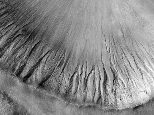
HiPOD: Gullies in the Depths of Hellas
Gullies are commonly found in the Martian mid-latitudes, particularly in the Southern Hemisphere. However, they are rare in the deepest parts of the massive Hellas impact basin.
One likely reason for this is that gullies are found on steep slopes, which seem to be less common in Hellas. For this image, HiRISE targeted a relatively fresh crater where previous images from the MRO Context Camera appeared to show gullies. This high-resolution look confirms the gullies and will allow scientists to compare them in detail with gullies elsewhere on the planet. (Image cutout is less than 5 km across.)
ID: ESP_082273_1360
date: 14 February 2024
altitude: 258 km
NASA/JPL-Caltech/UArizona
10 notes
·
View notes
Text

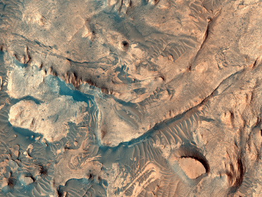
HiPOD: Sediment Ponds in Tithonium Chasma
This survey of the canyon floor of Tithonium Chasma in Valles Marineris reveals terrain of two distinct ages. The slopes and hilltops here are made up of rough rocky outcrop that was sculpted by impact craters of all sizes. In contrast, the valley floors are filled with light toned, smooth materials with far fewer large craters.
At HiRISE resolution, we can see that the “smooth” materials are in fact littered with boulders and small impact craters, so they cannot have been emplaced very recently. However, the absence of larger craters tells us that the smooth materials are much younger than the ancient rocky outcrops of the canyon floor.
The smooth materials appear to be sediments that were deposited possibly by the wind, long after the canyon was formed. The sediments filled in the low lying spots in the canyon floor, leaving a landscape that resembles lakes and ponds but is made up of dust and sand instead of water. (Image cutout is less than 5 km across.)
ID: ESP_082582_1755
date: 9 March 2024
altitude: 267 km
NASA/JPL-Caltech/UArizona
23 notes
·
View notes
Text
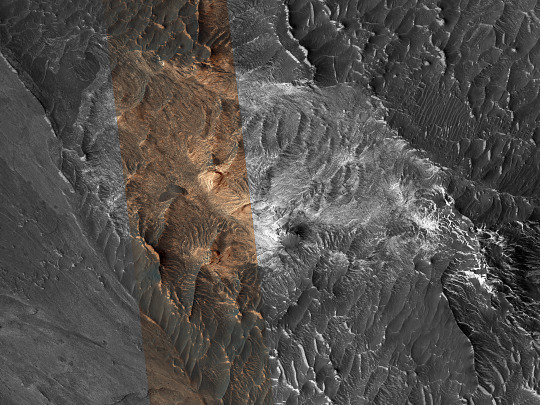
HiPOD: Hydrated Sulfates in Melas Chasma
This image was acquired to get more information about a site where the CRISM instrument detected hydrated sulfates. The bright materials are likely to be sediments rich in the hydrated sulfates, and this image shows that most of the material is covered by a thin deposit of dark material, perhaps sand.
We also see streamlined patterns that suggest fluvial processes were involved in depositing or eroding the sulfate-rich sediments. (Image cutout is less than 5 km across.)
ID: ESP_082700_1670
date: 18 March 2024
altitude: 265 km
NASA/JPL-Caltech/UArizona
18 notes
·
View notes
Text

HiPOD: A Channel in Huygens
The objective of this observation is to examine small, eroded channels. In this spot are many branched channels that have dark material on their floors. This image is located on what is left of the eroded southwest crater rim of Huygens, which is 467 km (290 mi) in diameter. The scene is also available in Context Camera data. (Black and white is less than 5 km across; enhanced color is less than 1 km.)
ID: ESP_075192_1625
date: 11 August 2022
altitude: 256 km
NASA/JPL-Caltech/UArizona
28 notes
·
View notes
Text

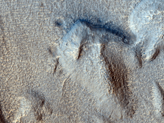
HiPOD: A Ridge in the Low Southern Latitudes
The objective of this observation is to determine the nature of a long straight ridge. At a point the ridge seems to disappear at the edge of an old crater and then reappear after a pause. It may be a dike. Along its length it has narrow portions and wide portions. The scene is also available in Context Camera data. (Black and white cutout is less than 5 km across; enhanced color is less than 1 km.)
ID: ESP_075020_1690
date: 28 July 2022
altitude: 260 km
NASA/JPL-Caltech/UArizona
39 notes
·
View notes
Text


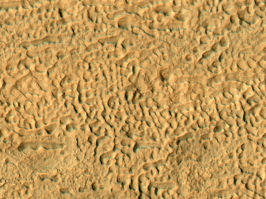
HiPOD: The Dunes of Change
The Mars Orbiter Camera imaged these dunes in 2000, so now we can learn what a multi-decade dune movement average is by taking a new observation to create a MOC-HiRISE temporal pair. With MOC providing a long baseline to newer HiRISE images, we can build up global averages of the effects of wind on the environment. Two decades is long enough that the dunes will have moved noticeably between MOC and HiRISE. (Grayscale cutout is less than 5 km across; enhanced color is less than 1 km.)
ID: ESP_075023_1980
date: 29 July 2022
altitude: 283 km
NASA/JPL-Caltech/UArizona
47 notes
·
View notes
Text
HiPOD: Fluvial Erosion in Harmakhis Vallis
This observation was requested by a Mars class to examine fluvial processes in one of the large channels leading into Harmakhis Vallis. The requested image is in a corner pointing opposite of the flow, possibly creating an eddy/turbulent area. The goal is to get a high resolution look for shoreline markings and erosion effects. Harmakhis Vallis probably formed by a combination of surface collapse and flowing water. (Grayscale cutout is less than 5 km across; enhanced color is less than 1 km.)
ID: ESP_075006_1410
date: 27 July 2022
altitude: 257 km
NASA/JPL-Caltech/UArizona
35 notes
·
View notes
Text
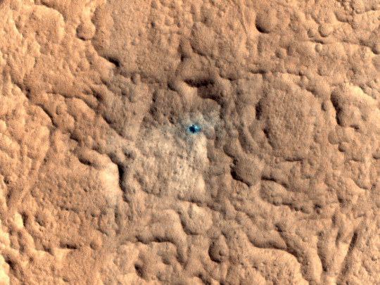
HiPOD: A Candidate Recent Impact Site
Why do we initially say “candidate”? Because before HiRISE acquires an image, the Context Camera on MRO might observe something that could be an impact, but their resolution is not like ours. So in one of their images, there was a large diffuse dark blast zone that was not present in an earlier observation, so that team asked HiRISE to acquire a high resolution picture to confirm if this is an impact crater. (Enhanced color cutout is less than 1 km across.)
ID: ESP_074999_1845
date: 27 July 2022
altitude: 270 km
NASA/JPL-Caltech/UArizona
31 notes
·
View notes
Text

HiPOD: Layering in Arabia Terra
The objective of this observation is to search for layering in Arabia. In Context Camera data, the layering shows up in buttes, ridges, and the edges of mesas. Our image may be able to see many more of these layers. This image will also help us to determine the horizonatal extent of layering in the region. (Grayscale cutout is less than 5 km across; enhanced color cutout is less than 1 km.)
ID: ESP_074982_2100
date: 25 July 2022
altitude: 290 km
NASA/JPL-Caltech/UArizona
28 notes
·
View notes
Text
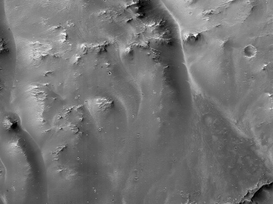
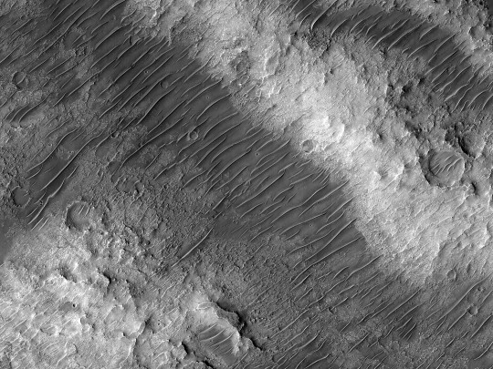
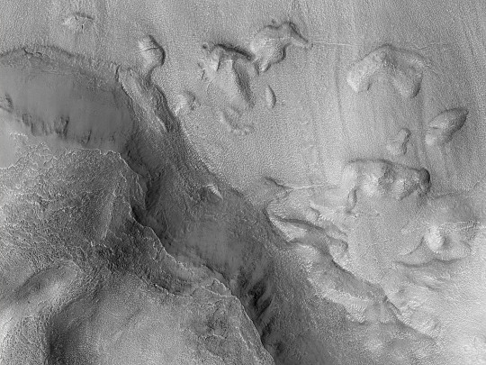
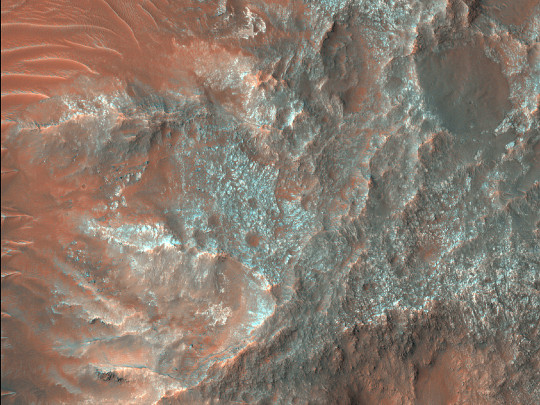
HiPOD: Channel, Fan, Crater
The objective of this observation is to examine a channel on a crater wall, where a fan has formed at the base. Images like this, also found in Context Camera data, may help us better understand how craters are degraded. This particular crater is one of many located to the northwest of the massive Hellas impact basin. (Grayscale cutout is less than 5 km across.)
ID: ESP_074982_1570
date: 25 July 2022
altitude: 257 km
NASA/JPL-Caltech/UArizona
22 notes
·
View notes
Text
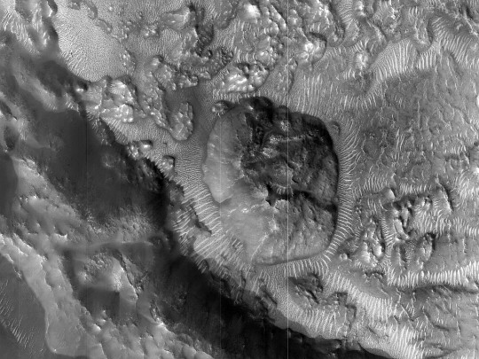
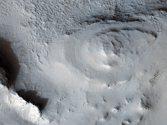
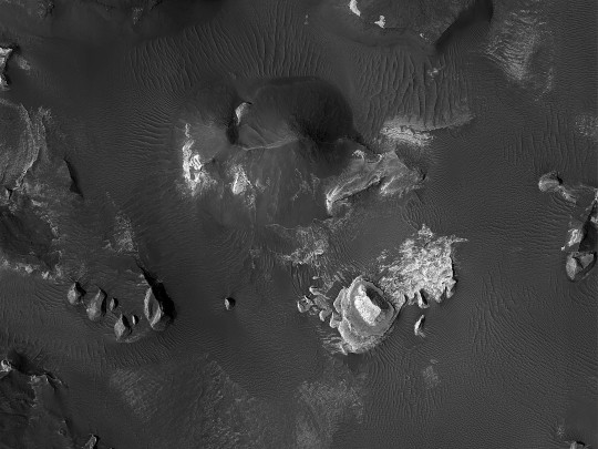
HiPOD: A Circular Landform within an Impact Crater
This circular formation appears to have the land around it sloping to its edge. The formation then looks to rise out of the ground with various others different formations around it. There also what appears to be a small crater on the top. When viewing this area using infrared background, the land formation has several markings on one side more than the other. (Grayscale image is less than 5 km across; enhanced color is less than 1 lm across.)
ID: ESP_074972_2085
date: 25 July 2022
altitude: 287 km
NASA/JPL-Caltech/UArizona
66 notes
·
View notes
Text
HiPOD: Bedrock Exposures in Nirgal Vallis
This observation covers two tributaries and the main channel of Nirgal Vallis. The channel is approximately 610 kilometers long and is named after Nergal, the Babylonian god of war and counterpart to the Roman god of war, Mars. Mars Orbiter Camera image show light-toned bedrock; our high resolution picture can gives us a better view of the channel form and bedrock stratigraphy. (Grayscale cutout is less than 5 km across; enhanced color is less than 1 km.)
ID: ESP_074945_1515
date: 23 July 2022
altitude: 257 km
NASA/JPL-Caltech/UArizona
34 notes
·
View notes
Text

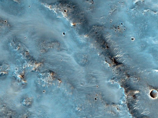
HiPOD: Light-Toned Materials within Iani Chaos
The objective of this observation is to get high resolution image to see more details about the light-toned deposits: could they be more sulfates or other hydrated materials? Iani Chaos is a region of chaos terrain at the south end of the Ares Vallis outflow channel. The chaotic terrain is believed to have formed by the removal of subsurface water or ice, resulting in flooding at the surface. (Both enhanced color cutouts are less than 1 km across.)
ID: ESP_074944_1800
date: 22 July 2022
altitude: 273 km
NASA/JPL-Caltech/UArizona
98 notes
·
View notes
Text

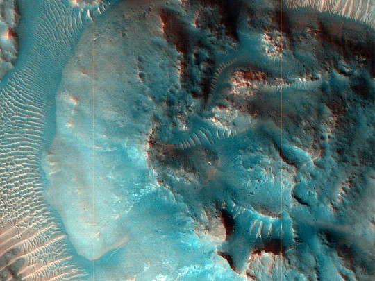
HiPOD: Gullies in a Crater near Newton Crater
The objective of this observation is to observe gullies in a crater. Pictures like this will help us increase our knowledge of the distribution of Martian gullies. Some of the gullies have quite wide, branched alcoves, and there are ridges of material at the base. Some researchers have suggested that the ridges are from former glaciers that came before the gullies. The floor of this crater is covered with pits and contains some small ring mold craters. (Grayscale cutout is less than 5 km across; enhanced color is less than 1 km.)
ID: ESP_074936_1380
date: 22 July 2022
altitude: 252 km
NASA/JPL-Caltech/UArizona
37 notes
·
View notes
Text
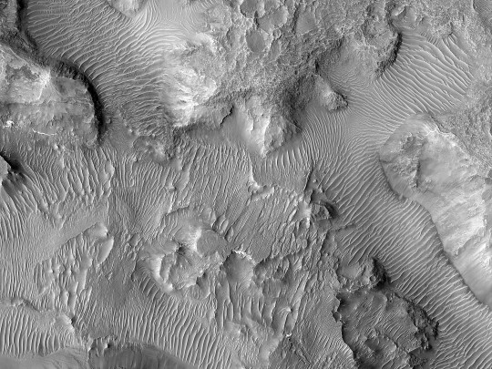
HiPOD: Light Toned in Aureum Chaos
The objective of this observation is to examine a light-toned, layered butte in a region of chaos. The field of view also inculdes several small outcrops of light-toned deposits. The OMEGA experiment on Mars Express discovered clay minerals in a variety places in Aureum Chaos. Clay minerals need water to form, so the area may once have contained large amounts of water. (Image cutout is less than 5 km across.)
ID: ESP_074918_1755
date: 20 July 2022
altitude: 270 km
NASA/JPL-Caltech/UArizona
31 notes
·
View notes
Text
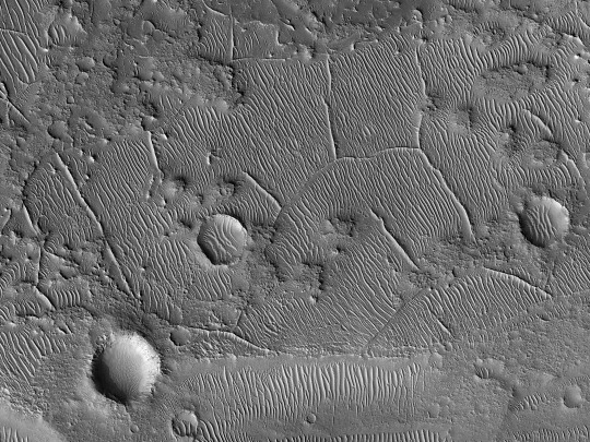

HiPOD: Ridges in Tempe Terra
The objective of this observation is to determine the nature of a network of ridges. The ridges are very regular in height and width and seem to be associated with a certain layer. The layer above the ridges has a darker-tone. Many of the ridges are joined to other ridges, some at close to right angles. (Grayscale cutout is less than 5 km across; enhanced color is less than 1 km.)
ID: ESP_074906_2160
date: 20 July 2022
altitude: 293 km
NASA/JPL-Caltech/UArizona
74 notes
·
View notes
Text

HiPOD: A Channel and Crater in Hesperia Planum
The objective of this observation is to examine a channel and an impact crater. The channel is narrow, and it maintains its width for a long distance and may be related to volcanism. Hesperia Planum is a broad lava plain in the southern highlands of Mars with a moderate amount of cratering indicating an intermediate geological age in Martian history. (Image cutout is less than 5 km across.)
ID: ESP_074900_1650
date: 19 July 2022
altitude: 259 km
NASA/JPL-Caltech/UArizona
18 notes
·
View notes