
Last Seen Blogs

dimspm
Dimspm
dontlookimnotabroad-blog
Short Stories

boogyus
aisha

fandom-imagine
fandom_imagine

totalaestheticisland
Aesthetics/Playlists for Total Drama
Text

Guayaquil, Ecuador, sits on the upper stretches of the Guayas River estuary, adjacent to a 235-square-mile (608-sq.-km) network of tributaries and mangrove forests. Since the 1970s, commercial shrimp farms have become commonplace in the estuary, leading to mangrove deforestation. This presents a conflict for Guayaquil, which benefits from shrimp exporting but is the planet’s fourth-most vulnerable city to future flooding due to climate change.
-2.208180°, -79.942960°
Source imagery: Maxar
114 notes
·
View notes
Text

Greater Tokyo, Japan, is one of the most populated and industrialized regions in the world. Encompassing several major cities, including Tokyo, Kawasaki and Yokohama, it is home to more than 38 million people. The so-called “Capital Region” also has the largest metropolitan economy in the world, with a total gross domestic product (GDP) of about $1.8 trillion.
35.689722°, 139.692222°
Source imagery: Airbus Space
122 notes
·
View notes
Text

This photograph, called “Earthrise,” was captured on Christmas Eve 1968 by astronaut Willam Anders aboard Apollo 8. It was the first time we had ever seen our planet like this, rising over the lunar landscape, and is believed to have been a catalyst for the first Earth Day in 1970. Earthrise helped spark a realization that we are moving through the infinite blackness of space, all together. It has inspired movements and momentum that help us work together to build a better future. Happy Earth Day.
Source imagery: NASA
362 notes
·
View notes
Text

Standing at 2,717 feet (828m), the Burj Khalifa is the tallest building in the world and the centerpiece of Downtown Dubai, UAE. The 163-floor structure overlooks the Dubai Fountain, the sprawling Dubai Mall, the Dubai Opera and other tourist attractions. Its design is an abstraction of the Hymenocallis, a type of desert flower that has long petals extending from its center.
25.197139°, 55.274111°
Source imagery: Maxar
116 notes
·
View notes
Text
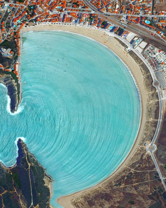
Calm waves roll into São Martinho do Porto — a village in Portugal with a shell-shape bay surrounded by a sand beach. The bay formed when a strip of land along the coast was eroded and then divided by the Atlantic Ocean. Because the opening to the ocean is still relatively small (825 feet or 250 meters), the waves that roll into the beach are almost always calm.
39.513000°, -9.134000°
Source imagery: Maxar
467 notes
·
View notes
Text
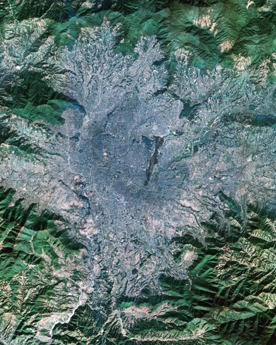
Kathmandu is the capital and most populous city in Nepal, with approximately 4 million inhabitants in its metropolitan area. Set in a valley of the Himalayas at an altitude of 4,600 feet (1,400 m), the city is often the first stop in Nepal for adventurers wishing to climb Mount Everest. It is also one of the oldest continuously inhabited places in the world and contains many ancient temples, pagodas and stupas.
27.710000°, 85.320000°
Source imagery: Maxar
135 notes
·
View notes
Text
111 West 57th Street is a residential skyscraper in Midtown Manhattan, New York City, constructed between 2015 and 2021. Also known as Steinway Tower, it is the fourth-tallest building in the United States at 1,428 feet (435 m) and the world’s thinnest skyscraper with a width-to-height ratio of about 1:24. Its 84 floors contain 60 luxury condominiums.
40.764550°, -73.977650°
Source imagery: Nearmap 3D
101 notes
·
View notes
Text
The world’s largest solar panel image, a horse, was constructed in the Kubuqi Desert of Inner Mongolia, China starting in 2017. This massive pattern was built with 196,320 solar panels and covers nearly 1.4 square kilometers (0.54 square miles). It is part of a larger photovoltaic generation base with an annual output of 4 billion kilowatt hours.
40.295360°, 109.670942°
Source imagery: Google Timelapse / Planet
206 notes
·
View notes
Text
A record 2.5 million Muslims gathered at the Great Mosque in Mecca, Saudi Arabia, last Friday to mark the Night of Power, one of the holiest nights of Ramadan. At center is the Kaaba, a cuboid stone structure that Muslims believe to be the Bayt Allāh, or “House of God.” Ramadan, the ninth month on the Islamic calendar, concluded on Tuesday with Eid al-Fitr.
21.422500°, 39.826111°
Image by Masjid Al Haram
377 notes
·
View notes
Text
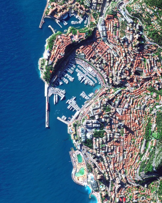
Monaco is a sovereign city-state on the French Riviera on the Mediterranean Sea. With an area of 0.81 square miles (2.1 square km), it is the second smallest country in the world, after Vatican City. This Overview features Port Hercules, the nation’s only deep-water port, as well as the Monte Carlo Casino and the Circuit de Monaco, the street course used for the annual Monaco Grand Prix Formula One race.
43.733333°, 7.416667°
Source imagery: Maxar
243 notes
·
View notes
Text
The Panama Canal runs about 40 miles (65 km) across the Isthmus of Panama, connecting the Atlantic and Pacific oceans. Completed in 1914, it saves ships traveling between the east and west coasts of the United States up to 8,000 nautical miles (15,000 km). Between 2007 and 2016, the canal underwent a major expansion project that doubled its capacity and allowed larger ships to pass through it.
9.125371°, -79.778215°
Source imagery: Google Timelapse
73 notes
·
View notes
Text
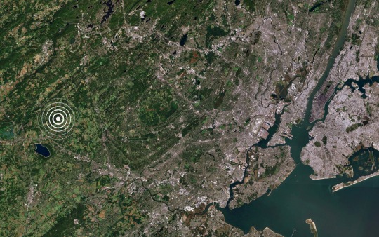
A magnitude-4.8 earthquake shook the Northeast United States this morning, causing tremors from Philadelphia to Boston. With the epicenter near Whitehouse Station, New Jersey — just 40 miles (64 km) from New York City — millions felt buildings shake throughout the Big Apple. Though little damage is reported, an earthquake of this magnitude is unusual for the region and is one of the strongest in New York State history.
40.615278°, -74.770556°
Source imagery: NASA
104 notes
·
View notes
Text
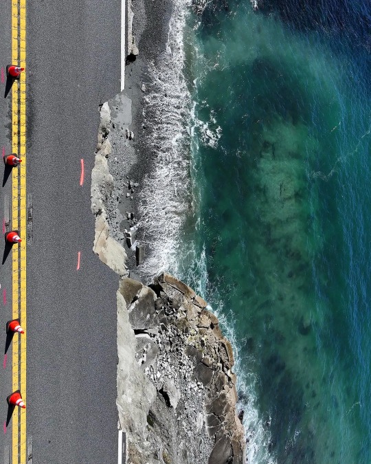
Parts of California’s scenic Highway 1 have been collapsing into the Pacific Ocean in recent days, as bouts of rain lead to landslides. Today, state officials temporarily shut down a stretch of the road near Big Sur and urged local residents to evacuate since more rain is expected through Friday. Around 2,000 people live in the Big Sur area year-round.
36.380383°, -121.901453°
Photograph by Justin Sullivan/Getty Images
309 notes
·
View notes
Text
A home in The Ponds neighborhood of Sydney, Australia, has gradually been surrounded by suburban development, as the family who owns it has declined to sell for decades. Despite offers as high as $50 million, the Zammit Family refuses to sell developers their 5-acre (2-hectare) lot, which could accommodate 40-50 new properties. This Timelapse video shows the neighborhood between 2010 and 2024.
-33.710156°, 150.895524°
Source imagery: Nearmap
268 notes
·
View notes
Text

Clean-up work continues on the collapsed Francis Scott Key Bridge in Baltimore, Maryland, which was struck by a container ship and critically damaged on March 26th. The cargo ship “Dali” remains stationary while crews use cranes to remove large pieces of twisted steel and concrete from the wreckage. One of the largest cranes on the Eastern Seaboard, capable of lifting 1,000 tons, is assisting with the effort.
39.216944°, -76.528333°
Source imagery: Nearmap
125 notes
·
View notes
Text
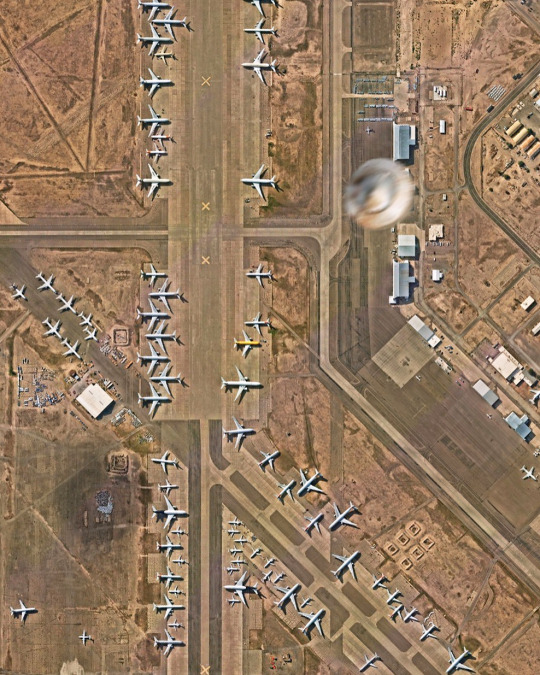
We found something unusual in this Overview of the Roswell International Air Center in Roswell, New Mexico. The airport, which served as a U.S. Army airfield during World War II and as Walker Air Force Base during the Cold War, is now a commercial airport serving the southwestern USA. It is known for the 1947 Roswell incident, a series of events surrounding the crash a U.S. Army Air Forces high-altitude balloon that involved theories about UFOs and extraterrestrials.
33.301556°, -104.530556°
Source imagery: Nearmap
123 notes
·
View notes
Text


Just two days left of our Spring Printshop Sale! Use discount code “SPRING20” to get 20% off all prints. Visit over-view.com/shop/prints to see the full collection.
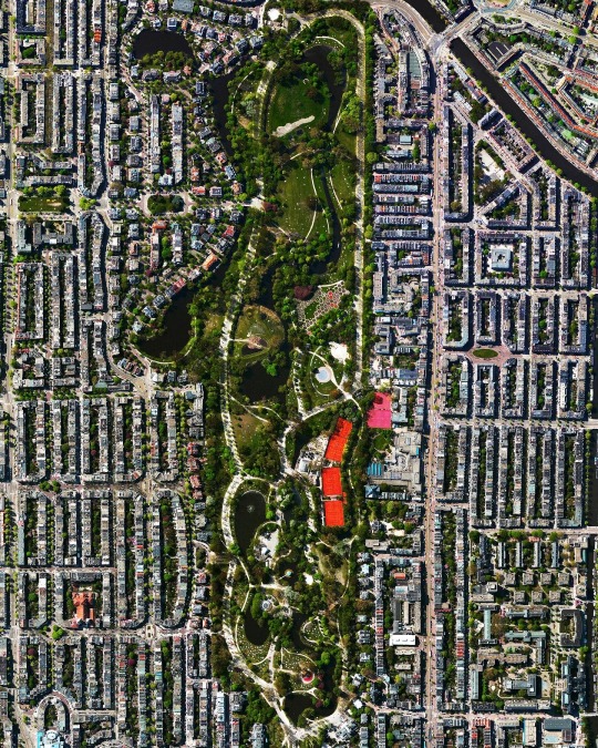
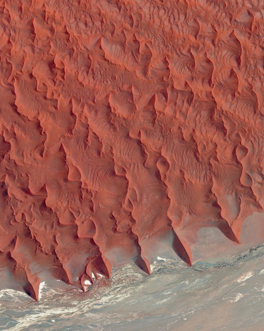
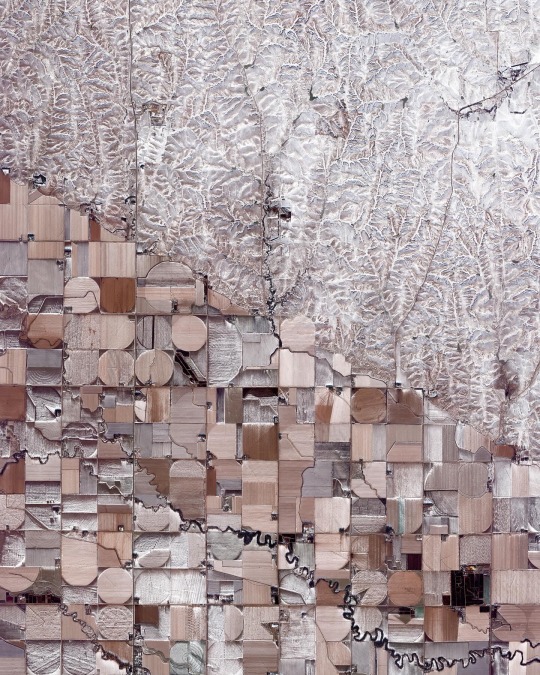
Prints seen here include:
Perth Waves
Singapore Tankers
Vondelpark
Sossusvlei
Nebraska Sand Hills
Sale ends 3/31 at midnight PST. Please note, the 20% discount is automatically applied to framed prints on the Level Frames website.
Source imagery: Maxar
132 notes
·
View notes