gravelish
Gravelish
Somewhat gravelly. My preference in beaches, bicycles, and backroads.
268 posts
Don't wanna be here? Send us removal request.
Last Seen Blogs


vedolosowa
Untitled

caughtinkorea
Musings of a Black Girl in Korea

benevolentcannibal
IT'SA ME CANNIBAL

nivomemen
Untitled
Text
Salt Lake City to Tucson
22 September - 13 October 2023

My last post was on September 14th, just before I headed to Salt Lake City to start my long-anticipated ride to Tucson. Since then I’ve had an amazing three-week adventure on the bike, I’ve had numerous enjoyable rides around Seattle, and I’ve spent hours going through the resulting photos and notes. But I’ve also struggled with my motivation and my interest in maintaining this blog. Regardless of what I end up doing with the blog, I thought it would be good to write up a summary of the recent trip. Whether I flesh out individual days of the ride or whether I continue to post about future rides remains unclear.
======
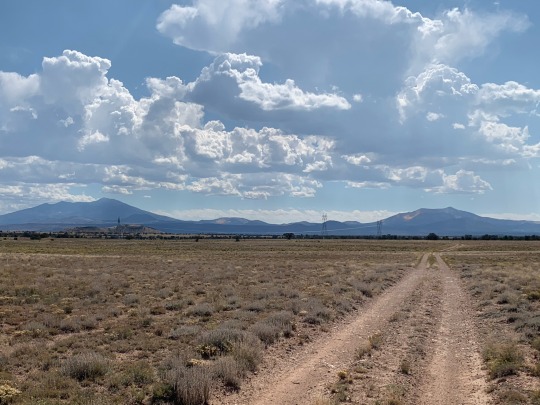
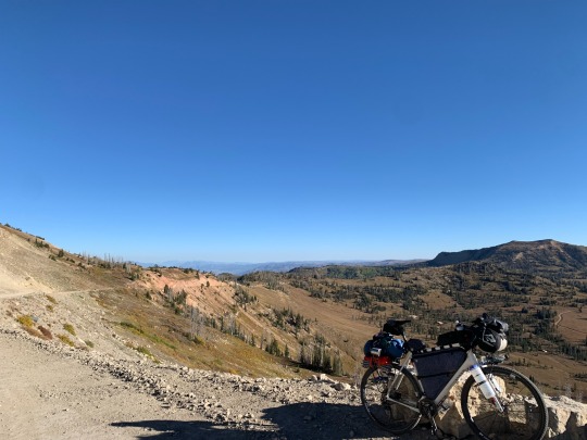
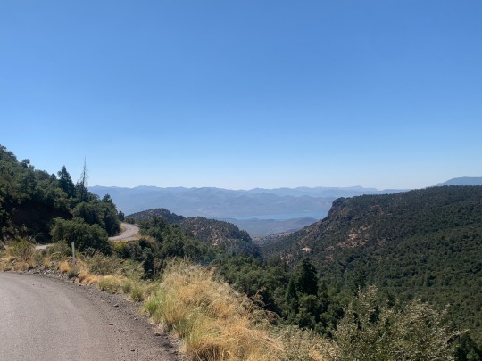
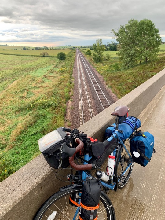
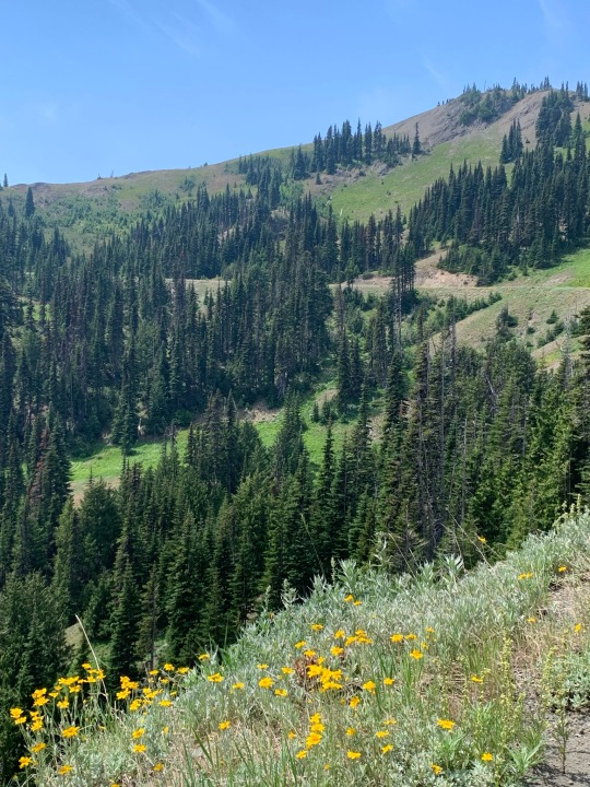
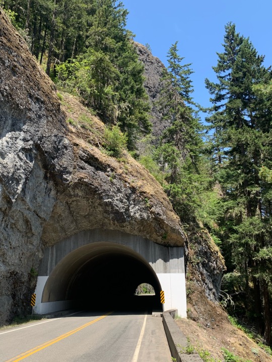
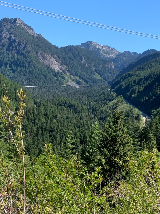
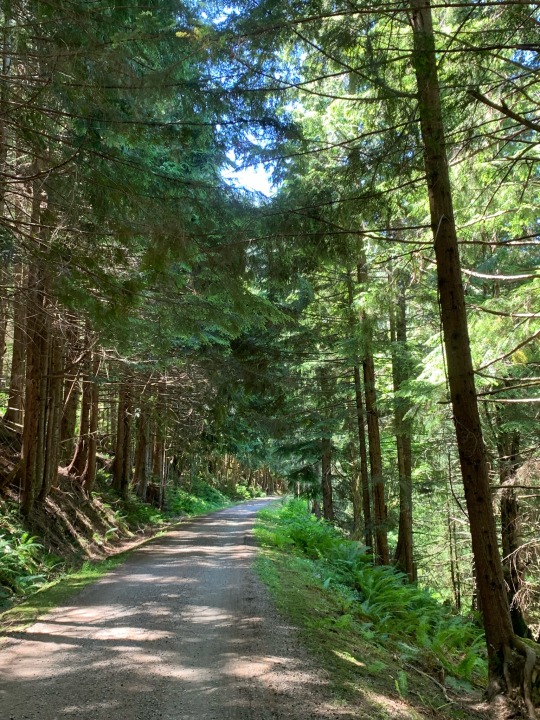
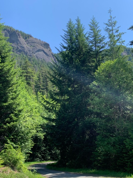
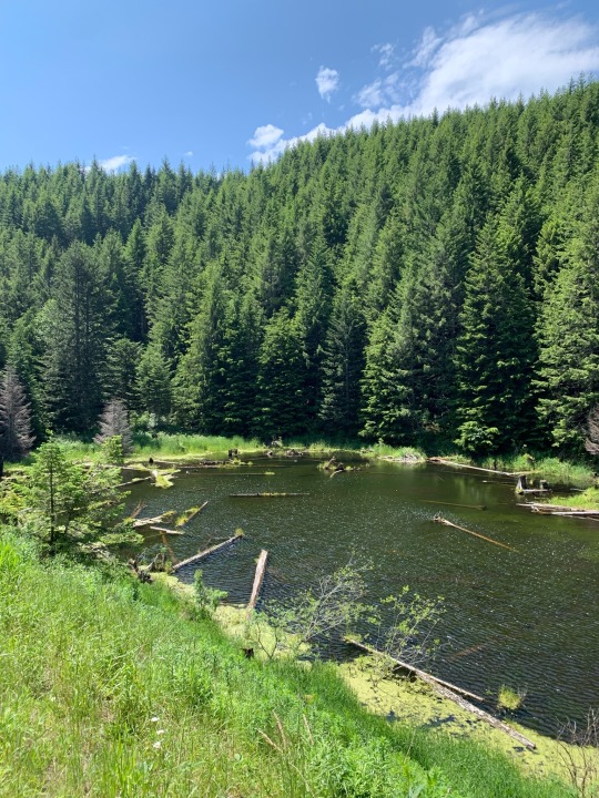
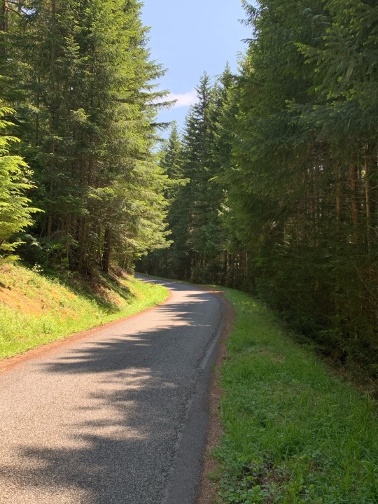
I rode out of Salt Lake City on Friday, September 22nd. I rode into Tucson on Friday, October 13th. Along the way, there were 22 days of amazing landscapes and incredible riding. I traveled around 1150 miles (50+ miles/day, more than 450 of it on gravel roads and dirt tracks. I suspect I walked my bike a total of 4-5 miles on steep or rough segments. There was 83,000’ of climbing, including several sustained climbs of 4-5,000’. Much of the first week was spent climbing to or riding above 10,000’. I camped a little less than half the nights. I never took a full day off, though I considered it in Flagstaff.

Highlights. There were a lot of them. Big Cottonwood Canyon and Guardsman Pass. Skyline Drive on the Wasatch Plateau. The aspens in the valley of Sevenmile Creek. Hell’s Backbone Road. Scenic Route 12 from Boulder to Escalante. Bryce and Red Canyons. Camping at Rock Point on the edge of Marble Canyon. The South Rim of the Grand Canyon. The San Francisco Peaks. The Mogollon Rim and the amazing descent to the Salt River.


The weather was great, except for some rain in southern Utah that required a major detour to avoid muddy roads and added two days to the trip. Temperatures were cold at night, particularly on the Wasatch Plateau, but it was great during the day. Heat was never a problem during the ride itself, though the weekend after I got to Tucson, temperatures rose into the high 90s.
My route evolved over many months of pouring over maps and checking online sources. Some of the territory was familiar to me and that influenced decisions about places I wanted to visit (or felt okay skipping). I wanted to experience as wide a range of landscapes and geologic provinces as I could. I wanted to avoid busy highways, but I also didn’t want a route that was too rough and too remote for my bike or my capabilities (particularly riding solo).
The result was a wonderful mix of roads and trails. Almost 600 miles of my route was on the Western Wildlands Route (courtesy of Bikepacking Roots), a north-south route from Canada to Mexico that parallels, but lies farther west than, the better known Great Divide Mountain Bike Route.
Here’s a list of each day, showing mileages and elevation gain. I may eventually work up descriptions of each day and link them here, but haven’t done so yet. I posted fairly regularly on Instagram (@gravelbeach) and that remains a source of photos and limited narrative.
9-22 Salt Lake City to Brighton 28.4 miles 4122’
9-23 Brighton to Currant Creek Summit 41.8 6634’
9-24 Currant Creek Summit - Scofield 67.6 5012’
9-25 Scofield - Skyline 45.1 5467’
9-26 Skyline - Salina 66.5 3856’
9-27 Salina - Fish Lake 44.2 5748’
9-28 Fish Lake - Posey Lake 54.1 4385’
9-29 Posey Lake - Boulder 23.7 2440’
9-30 Boulder - Cannonville 64.7 4176’
10-1 Cannonville - Hatch 33.1 2342’
10-2 Hatch - Kanab 57.4 2440’
10-3 Kanab - Page 76.8 2449’
10-4 Page - Rock Point 45.4 3348’
10-5 Rock Point - Cameron 65.1 1997’
10-6 Cameron - Grandview 47.6 4519’
10-7 Grandview - Kelly Tank 54.0 2709’
10-8 Kelly Tank - Flagstaff 35.6 2405’
10-9 Flagstaff - Kehl Springs 72.5 3618’
10-10 Kehl Springs - Young 64.9 3459’
10-11 Young - Globe 67.6 6032’
10-12 Globe - Willow Springs 53.7 4172’
10-13 Willow Springs - Tucson 61.0 1696’
LINK to Ride with GPS: Collection of all 22 rides
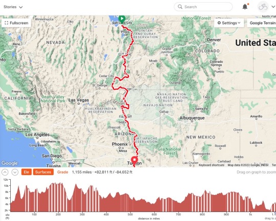
TOTALS (numbers vary depending on later corrections):
1170.6 miles (53.21 miles/day) (1884 kms)
690 miles paved / 480 milesunpaved
83016’ (3773’/day) (25,303 m)
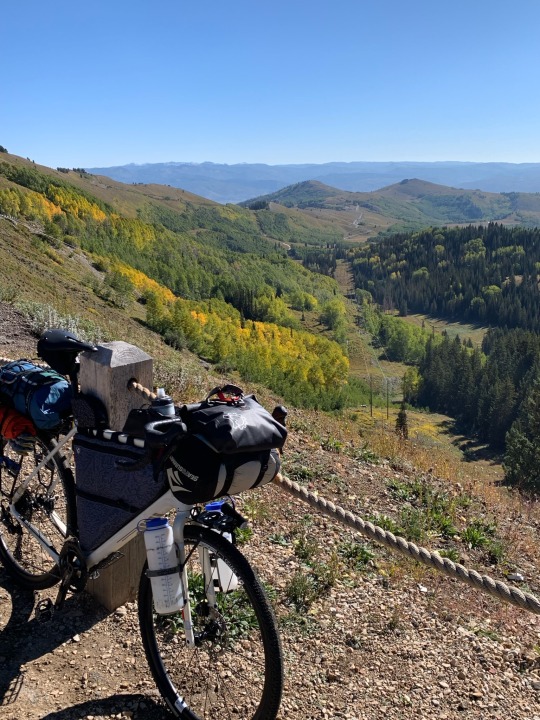
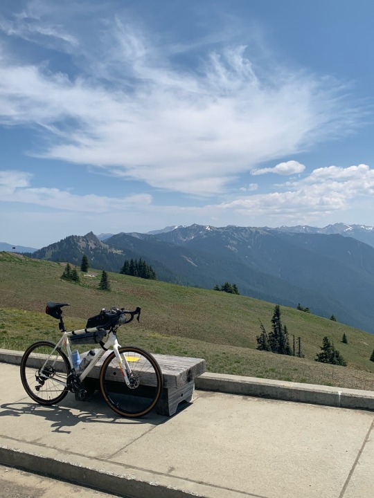
My bike and my gear worked out well. I rode my Salsa Warbird with a bikepacking setup. I’m on 42mm tires (tubeless). I had no tire problems, despite sharp chunky volcanic rocks and the potential for goathead thorns. My suspension stem and seat post make the rough roads a little less jarring. My only mechanical problem was a missing chain ring bolt that I discovered on the second day and was able to get fixed. I replaced the brake pads in Flagstaff. Shifting worked fine (and continues to work smoothly after shipping the bike home and adding another few hundred miles around here).
My body held together, despite turning 65 on Day 4. I never had any problems with altitude besides the labored breathing you’d expect from 5000’ climbs to 10,000’. My lips were badly chapped and my skin got darker. My hands and seat were sore at times, but that was to be expected and was never an obstacle. My legs were sore when riding, but recovered quickly.
I’d been thinking about this ride ever since I wrapped last year’s trip from Whitefish MT to Salt Lake City. It was an inevitable second chapter to what became an epic ride that stretched from border to border (a one day’s ride from either end). Combined, the two-part adventure covered 2200 miles and 130,000’ climbing over 40 days of riding.
4 notes
·
View notes
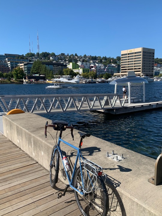
Text
Green Lake and Lake Union
14 September 2023
I wouldn’t normally do this, but I decided to simply copy this text from my corresponding Instagram post. It’s a short story about two bikes.
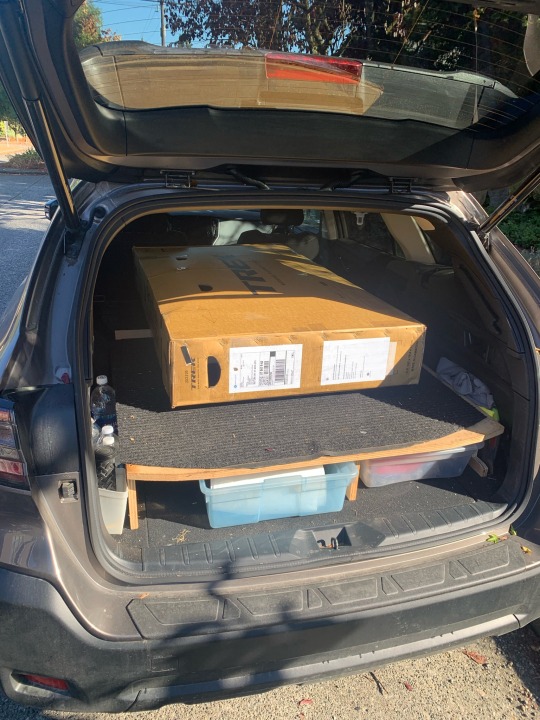
I took my Surly out for a ride this afternoon since my Warbird is at the UPS Store, packed into a cardboard box with my camping gear, and headed for Utah.
Four years ago today, I was riding this bike from Carroll to Onawa in lowa, sheltering from thunderstorms in Westside and Vail in the morning and rolling through the Loess Hills in the afternoon. I was three weeks from Maine; still four weeks from Seattle.
Since then it's seen a few thousand miles on the indoor trainer (mainly in the virtual worlds of Watopia and the Makuri Islands) but I think this was the first time it's been outside since I bought my Salsa Warbird in early 2020. The Disc Trucker is a great bike, but the Warbird is more fun to ride and has become my go-to bike for everything from short rides around home to epic adventures in the Rockies.
With any luck, it (the Warbird) should be waiting for me next week when I arrive in Salt Lake City!


0 notes
Text
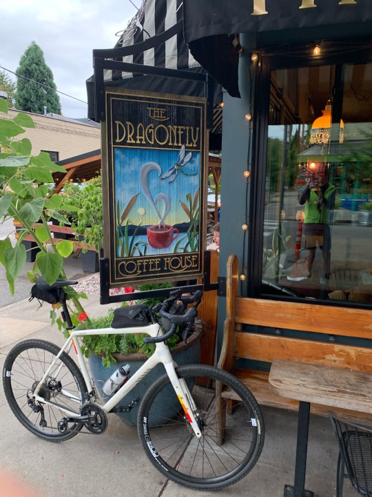
Portland Riverfront
7 September 2023
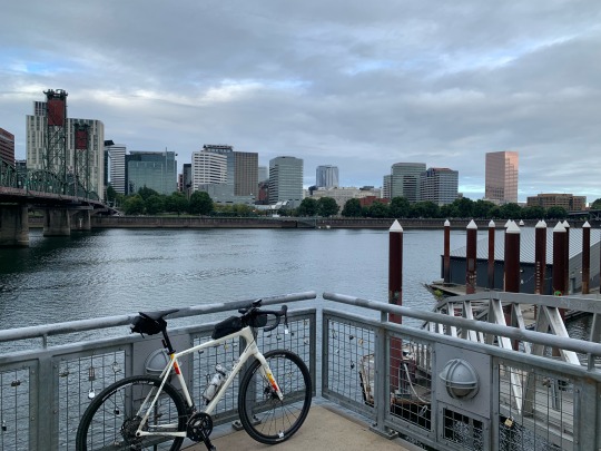
This ride began at Dragonfly (coffee, of course), but then headed down to the Willamette River.
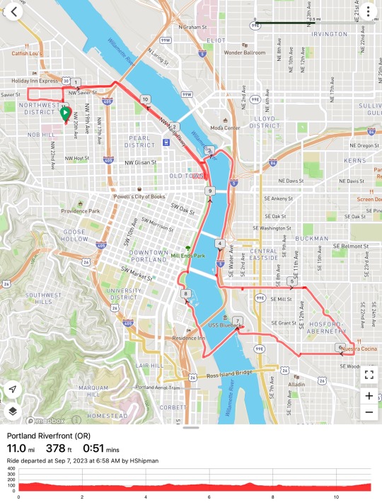
I followed the trail along the east bank of the river south, then through neighborhoods south of Hawthorne, where I found, by chance, Upper Left Roasters. Another cup of coffee.
I returned along the west bank of the river, past downtown, and back to the Northwest neighborhood where we were staying.


1 note
·
View note
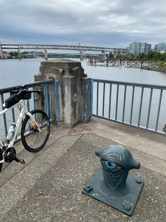
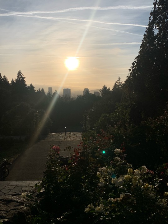
Text
Northwest Portland (OR)
5 September 2023

This ride began with a stiff climb up through Washington Park to the hills west of downtown. It ended with a stop at Dragonfly Coffehouse on Thurman.
The backside of the loop was on Skyline Boulevard, which at 8:00 in the morning was pretty busy. Maybe a little too busy for comfort, given the hilly, winding road and the lack of shoulders.
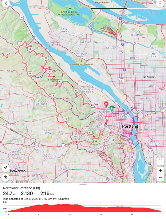
I turned back down the hill on Germantown Road. Going uphill would have been nasty given the narrow road and traffic, but going downhill was fine since I was going pretty much as fast as the cars all the way down to the turnoff into Leif Erikson Drive.
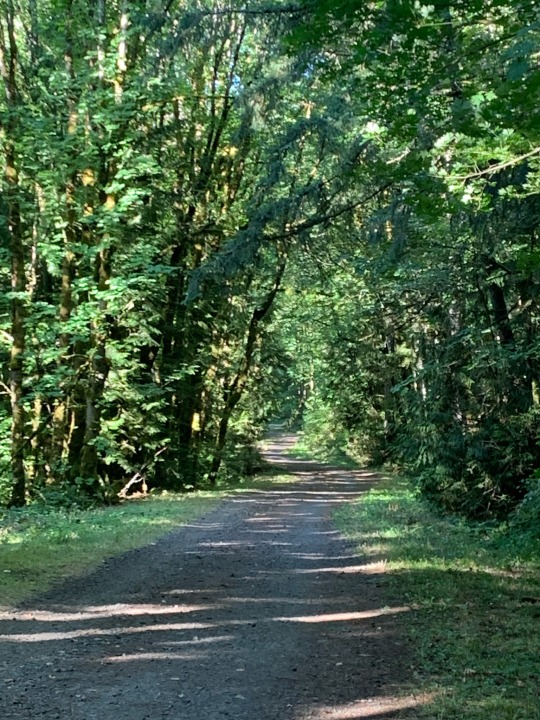
Leif Erikson is an old roadway (closed now to cars) that winds through Forest Park all the way back to town, where it eventually becomes NW Thurman Street. There were a few runners, a few cyclists, and a few dog walkers, but for the most part, I had it to myself.
I rode a shorter variation of this route last year (June 2019).

0 notes
Text
Lake Washington
3 September 2023

A lot of my longer rides from home involve loops around parts of Lake Washington. Good bike paths, including on both of the floating bridges, offer plenty of permutations and different length rides.
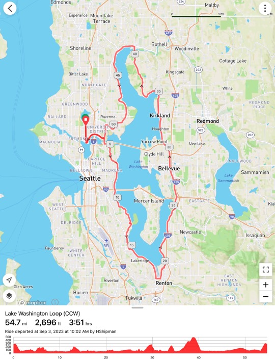

Today was the first time I’d just ridden the full loop in a long time. It’s not quite a metric century (though it would be easy to make it one with a little more riding).
It’s a pretty flat ride. There is one big hill on the northwest side between Juanita and Kenmore. And there are several much smaller hills. The second biggest climb is the one back to the house at the end (inevitably, most of my rides end with a ten-minute climb).

1 note
·
View note
Text
Tsawwassen and Ladner (BC)
11 August 2023
(Posted out of order - this ride preceded Salt Spring Island)
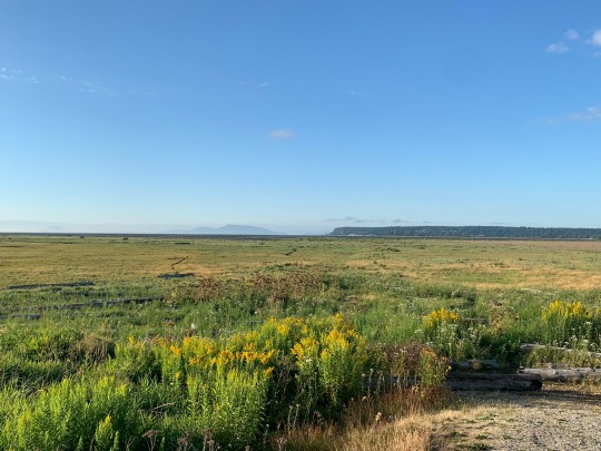
Locals will likely correct me, but I believe Tsawwassen and Ladner are both communities within the larger city of Delta. We were staying in Tsawwassen, as we often do the night before catching the ferry to Salt Spring Island, and as usual, that meant I had the early morning to go off searching for coffee and pastries.
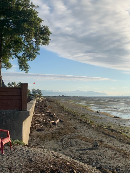
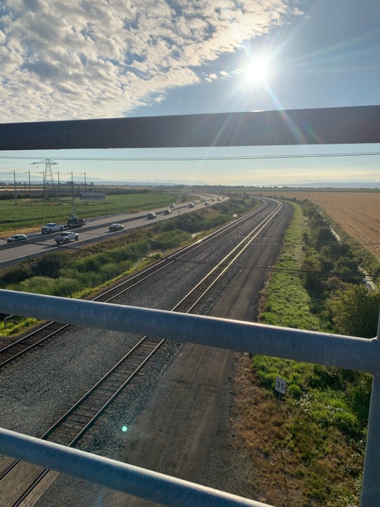
As it’s name implies, Delta is at the mouth of the Fraser and is awfully flat. Tsawwassen itself is actually on a hill (it was an island before the river delta grew around it) but otherwise the only topographic relief to this ride was an overpass.
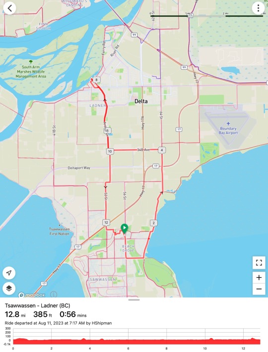
I rode down to Beach Grove, along the Boundary Bay Dike Trail, then north and west on a grid of farm roads toward Ladner, which is located on the southern bank of a secondary channel off the Fraser. My advance work had identified Stir Coffee House, but had not alerted me to the size of the cinammon buns, which were disproportionately large for such a modest bike ride. Not that I couldn’t deal with it.
1 note
·
View note
Text
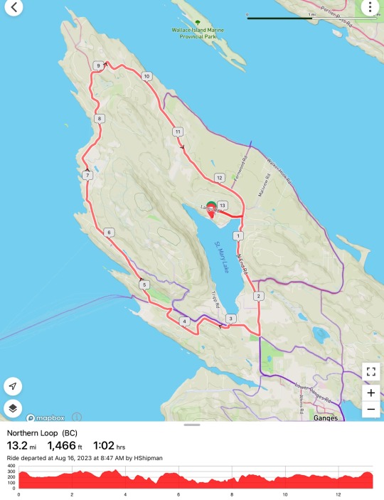
Salt Spring Island
12, 14, and 16 August 2023
We spent the second week of August on Salt Spring Island, as we have every year, except 2020, for 26 years. I managed three modest bike rides, all on familiar territory and for the most part on routes I've covered in this blog in previous years.
Fernwood Loop
This is a simple loop that includes a wonderful leg on Walker Hook Road along Trincomali Channel on Salt Spring’s northeast shore. Whichever way you go, there’s a steep hill at one end or the other when you leave the water, but otherwise it’s not terribly demanding. The route passes the government pier at Fernwood and requires a stop at the small cafe across the street, which pretty much doubles the length of the ride while negating all the calories burnt.

North End Loop
North End Road and Sunset Drive are constantly going up and down, though none of the hills are very long. I I think the worst climbs are steepest going clockwise (which happens to be the way I rode it today). The worst is the one at Duck Creek near Vesuvius (just past Mile 5). I prefer the ride early in the morning when there are fewer cars.
Long Harbor
This was basically an out-and-back to Long Harbor and Scott Point, with a loop back through Ganges (for coffee, of course). I think Long Harbor Road is one of the nicest stretches of road to ride on the island, as long as the ferry hasn’t just gotten in. Because it serves the ferry, the road is wide and even has a well-marked shoulder, something rare on the island, and it rarely has much traffic (again, if you avoid the ferry rush). It’s rolling, but never steep. There were some steep hills on some of the other roads though they were short. The longest climb was on Rainbow Road heading northwest out of Ganges (around Mile 16).


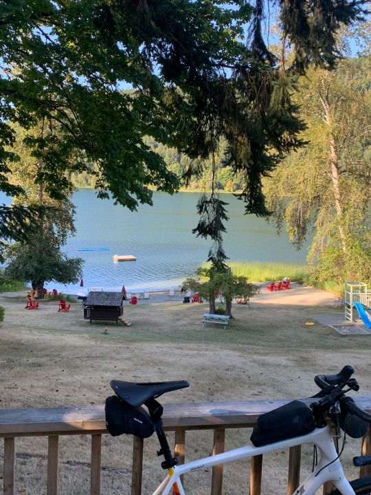
Our base on the island, as it has been for the quarter century we’ve been coming up here, is a small cabin resort on St. Mary Lake, about a ten-minute drive (or a twenty-minute bike ride) from Ganges.
1 note
·
View note
Text
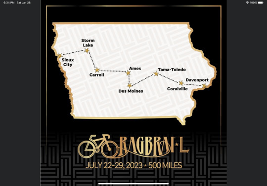
RAGBRAI Part 2 (Iowa)
22-29 July 2023
This is Part Two of my account of this year’s ride across Iowa. These posts have been festering in a ‘drafts’ folder for a month and a half and now I’m determined to just get them out. This one is more of a chronological account of the last few days of the ride, combined with some overall observations of the whole spectacle.
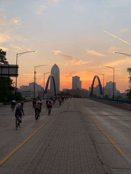
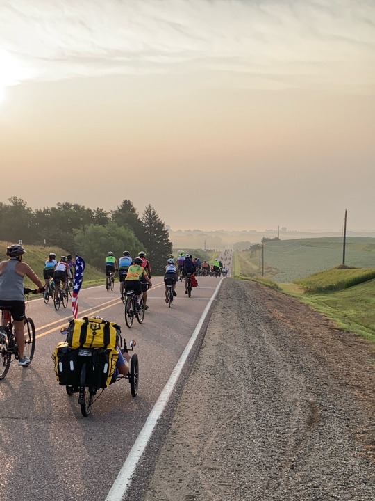
Day 5 of RAGBRAI began with a beautiful pre-dawn ride through downtown Des Moines and out of the city to the east. This was the longest and hilliest day of the week-long ride, covering about 90 miles and climbing 4000’. We passed through Newton, where I’d stayed on my eastbound ride in 2019 and Grinnell before ending the day in the twin towns of Tama and Toledo.

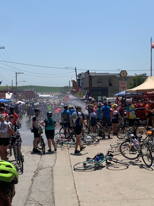
Day 6 included Marengo and the Amana villages, but Oxford has become the most memorable pass-through town of the whole trip for me, simply because of the heat. The fire station doors were wide open and there were tables lined with folks enjoying shade and cooling fans and ice cream. There was an old fire truck parked outside and an open hydrant spraying water across the passing riders (all walking their bikes through town). The final 15 miles to Coralville was miserable but misery shared among thousands. It was hilly and hot and humid (‘feels like 113’). People, including me, were stopping at virtually every hilltop farmhouse to sit in the grass under the trees and to empty water bottles over our heads. Everyone was checking on everyone else for signs of heat stroke. And there were clearly several riders along side the road getting attention (from other cyclists and from occasional ambulances).
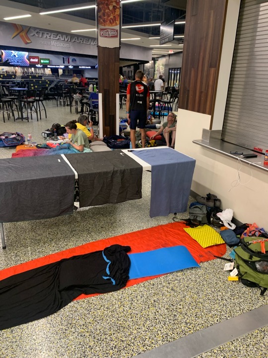
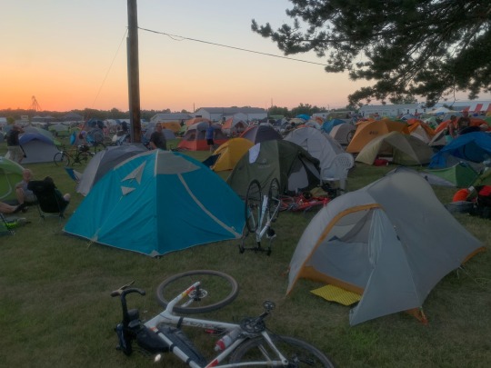
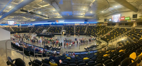
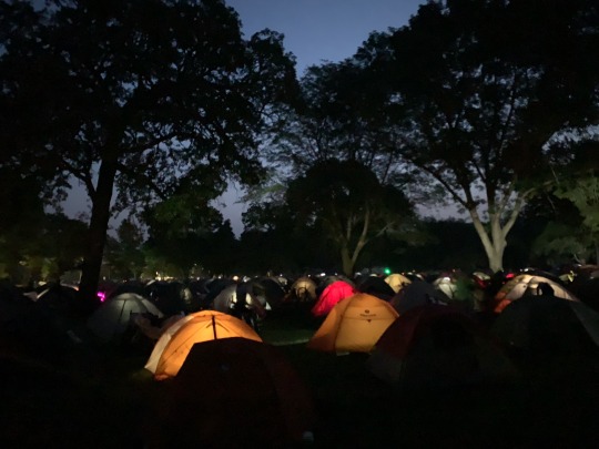
I arrived at the Pork Belly camp in Coralville around 3:00. I was not looking forward to pitching my tent in the hot sun, so when I heard that they had opened up more space in the nearby Xtreme Arena for a small donation, I jumped on it. I set up ‘camp’ on the concourse, amidst many others. I didn’t even hear the sirens and commotion outside when the storm arrived two hours later. Strong winds were tossing tents around and sending folks fleeing for the arena (which they had opened for everyone by then). Pork Belly moved the dinner service and the band into the arena which was wonderful (this was still mainly just the Pork Belly crowd, so while it was crowded, it was pretty spread out given the size of the facility. Things were crazier in the main RAGBRAI camps). It was so nice to spend a night in an air conditioned space.
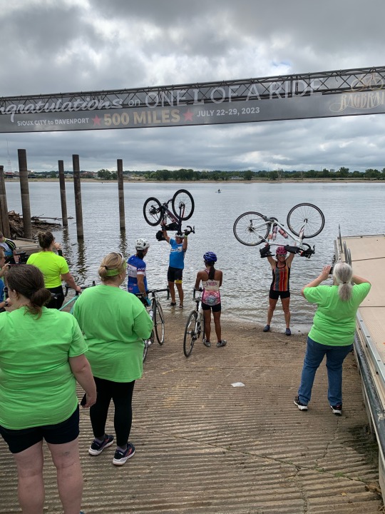
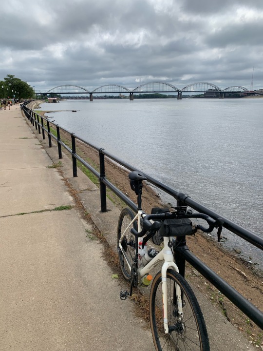
Saturday (Day 7) was a very early start because of the potential heat and the urgency about getting to Davenport in time to get the afternoon shuttle back to Omaha. Route finding out of Coralville and through Iowa City in the dark at 5:30 was confusing, in part because the route was designed to go through the University of Iowa and Kinnick Stadium, but that wasn’t actually open until 6:00 am and instructions weren’t clear. The 70 miles went fast and was one of the nicest rides of the trip, in part due to cloud cover. We reached the Mississippi River in Muscatine, but then followed it the final 25 miles to Davenport. I stopped for ice cream at a Beekman’s stand along the way and joined others on plastic chairs along the shoulder cheering the crowd as they rode by (in previous days, the lines at Beekman’s had always been prohibitively long and the lack of cloud cover meant little interest in sitting anywhere without shade).
I dipped my wheel in the Mississippi around 11:00 (I’ve never ridden 70 miles by 11:00 am before!). The boat ramp was crowded, but it was only a few minute wait (I heard that by afternoon the line was much, much longer). I took my time riding along the riverfront park - this is where I crossed the Mississippi River in 2019 on my way west. Then it was a mile uphill to the St. Ambrose campus, where Pork Belly was set up. I put my bike on the ‘Stupidity’ trailer, retrieved my bags, visited the shower truck, grabbed a burger and a drink, and made it onto the first (of 8?) coaches headed back to Omaha that afternoon.
The bus trip was 5-6 hours, all on I-80, but it went by quickly. Everyone was excited about finishing the 7-day ride (and having already ridden 70 miles just that morning). I think we all let our guards down, since I’m pretty sure that’s where I picked up COVID, which I proceeded to share with M and C when I arrived home two days later!
Aside from the heat and the crowds and the lines, RAGBRAI was an amazing experience. I’m really glad I did it. Once. I appreciate that many people will want to do it again and again. But it’s just not the kind of experience I ride for. I like solitude. I like the interaction with locals in their normal lives, not during a traveling festival that has turned their lives upside down for a day. I don’t like heat and mugginess and damp gear that never dries out and sleeping in a tent when the temperature never drops below the high 70s. I’ve always been a bit bugged by the collegiate focus on partying and drinking - which may not accurately characterize most participants, but which was a dominant theme leading up to and during the event. Serving up vodka lemonade slushies in front yards and crowded beer gardens and countless Facebook posts about riding from beer stop to beer stop along the route contributes to this.
I talked to a lot of other riders on this trip. They came from a wide variety of places and personal histories and biking backgrounds. It was a great reminder of how different we all are, in what we’ve done, what we enjoy, and what inspires us, despite the fact that we all share an interest in the same thing and look sort of the same in our Lycra and our helmets.
I spent the week thinking how this ride compared with 2019. That was a tough five days, but if I ever want to ride across Iowa again, that’s the way I’d do it. And while I enjoy the landscapes of the Midwest, I’d rather be riding in the mountains or along the coast, through the forest or in a dramatic urban landscape.

2 notes
·
View notes
Text
RAGBRAI Part 1 (Iowa)
22-29 July 2023
I’m a cyclist who prefers riding empty gravel roads in the mountains and excursions to the beach or the coffee shop, but I’d been hearing about RAGBRAI for years and I guess I thought it might be a unique experience to round out my cycling resume. That’s how I ended up spending the last week of July riding across Iowa with a few tens of thousands of other cyclists.
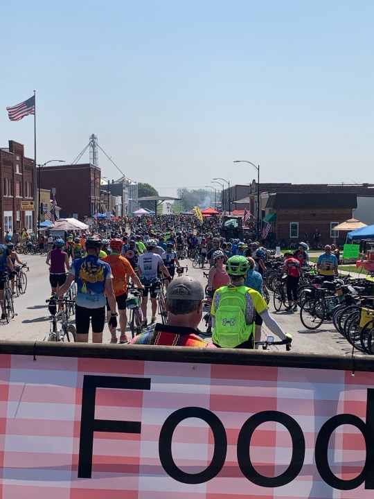
RAGBRAI, the (Des Moines) Register’s Annual Great Bike Ride Across Iowa, is celebrating its 50th year. It was already the largest bike event in the country (perhaps the world?) and anniversary hype, combined with post-pandemic enthusiasm for getting out and doing stuff, resulted in record turnout. Reportedly, almost 30,000 people registered for it this year, though the actual numbers are hard to parse. Some people ride without registering. Some people ride for just one or two days. The 4th day, between Ames and Des Moines, was rumored to have 60,000 riders. But the last couple of days may have had many fewer as heat and exhaustion took their toll and people opted to drop out.
I came away impressed by the attraction this event holds for so many people and that so many come back to do it year after year. I suppose there were as many motivations as there were participants, but for some it was an annual ritual, an excuse to challenge themselves physically, an excuse to drink while riding their bike, or simply an opportunity to do something with an awful lot of similarly minded and equally enthusiastic people. I was really glad to experience RAGBRAI, even in a particularly crowded, longer, hotter year like this one, but am not drawn to doing it again. It was absolutely amazing and emotionally powerful to be part of something this big, but for me there are so many other, more enjoyable, ways to spend a week on a bicycle.
I’m breaking my rambling account into two parts, if only so I can include more photos (Tumblr limits me to 10 images per post). I also don’t think each day really warrants its own post - they were all much the same. The details varied, but the basic routine, the riding, the towns, the activities and the vendors, the heat and humidity, and the landscape remained fairly similar every day.
I have RWGPS (and Strava) records of 6 of the 7 days, but I’ve decided just to include the overview map. In Storm Lake, on Day Two, I accidentally packed my Wahoo Bolt into my gear bags and tossed it on the truck, resulting in the only ride in the last five years for which I don’t have a digital record!
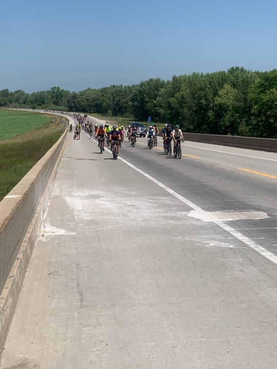
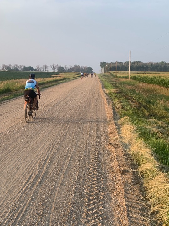
The ride covered more than 500 miles in seven days. There was a lot of climbing. While Iowa is clearly not mountainous, it is by no means flat, and for every minute spent coasting down each hill, there are 4-5 minutes spent crawling up the next. And given the crowds, the uphills tended to bog down and even stall. And it was hot. It’s July in the Midwest, so heat is to be expected, but this week was particularly warm and unusually muggy. This was increasingly true later in the week and on Day 6 temperatures reached the high 90s and the ‘feels like’ temperature was reported to be 113. Even folks from New Orleans and Atlanta were calling the humidity ‘brutal.’
The heat and the crowded roads encouraged early starts. I generally woke in the dark to the noise of tent zippers and deflating air mattresses around 5:00, which was fine, since I found this schedule worked well for me, too. I’d pack my gear, throw it on the truck, wait in line at the portapotties (called KYBOs), then I’d grab coffee and something to eat, but I was typically riding out at 6:00 (a little before sunrise). The early start meant the riding was more pleasant, but it also meant long afternoons in camp without much shelter from the sun (and certainly no AC).
My view of the larger ride was limited by my position in the pack. I was early in the daily wave of riders, though by no means the earliest. If I had to guess, there were probably already a couple thousand folks on the road when I took off, but that means there were still more than 20,000 behind me. I suppose I was similarly positioned at the end of the day - there were already people in camp by early afternoon when I rode in (they'd usually secured the shadiest tent sites), but there thousands of others continuing to arrive well into the evening.
Each day was bracketed by the ‘overnight’ towns at each end and broken into chunks 4-5 ‘pass-through' towns along the way. The overnight towns turned into huge encampments, with all sorts of support services (food, drink, bike repair, showers, bike clothing, RAGBRAI swag). Downtown areas were turned into huge street fairs. There were concerts, including some major bands. I was part of the self-supported camping scene, but many people were staying in rented homes, hotel rooms, or family RVs that were providing support. There were groups and clubs with their own school buses and vans.
The pass-through towns were like county fairs. For each town, there was a wave of people passing through over many hours. Perhaps more people than have ever passed through the town before (RAGBRAI follows a different route, through different towns, each year). The towns are packed and everyone is walking their bikes. The main streets are lined with vendors, first aid stations, and booths with folks highlighting bike-related organizations or groups raising money for the local library or kids needing cancer treatment. Firehouses open their doors. There are places to fill water bottles. There are bands playing in the parks.
And then on the route between towns there are more folks selling Gatorade and water, handing out popsicles, and offering up the front yards of their farmhouses for shade and rest. Iowa breweries take over entire farmyards for beer tents. Every day, one passes Mr. Porkchop, Sassy Lemonade, Chris’s Cakes, and Beekman’s Ice Cream, and an assortment of other event-specific or regional vendors.


One can ride RAGBRAI using simply the services that come with your entry fee, but many people choose to go with a charter service that provides more logistical support, better food options, and enhanced services (showers, charging stations, more KYBOs). I went with the largest, Pork Belly Ventures, and was glad I did. They accommodated 1500 of us with the help of a great many staff and more than a dozen specially equipped semis that provided showers, food, gear transport, and even some air conditioned rooms for those who reserved early. The logistics of this (not just Pork Belly's, but of the entire event) were fascinating and a little overwhelming.

It was impossible for me not to constantly compare this ride to my five days crossing Iowa in 2019, on my way from Maine to Seattle. I was following a remarkably similar route, albeit in the opposite direction. I rode through Davenport, Marengo, Newton, Ankeny, Jefferson, and Carroll, all towns on this year’s ride.
But in 2019 I did it all by myself. I talked with other bicyclists - they were just fewer and farther between. I talked with folks at gas stations and restaurants and parks along the way. But when you’re on your own, your interaction with people, with towns, and with the landscape is completely different. And for me, much more pleasant and meaningful. RAGBRAI is a big party and the event itself dominates the experience.
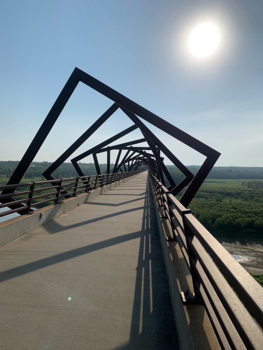
In 2019, I was on bike paths through much of the area northeast and northwest of Des Moines (the area’s done a great job on these). But this year, the huge crowds precluded the use of the trails and we stuck to the roads. So a vast majority of riders never got a chance to ride see the High Trestle Bridge, just west of Madrid. It had been a highlight of my 2019 ride through Iowa (12 September 2019: High Trestle Bridge). There were reports it would be closed for RAGBRAI (crowding concerns), but at 8:00 am, when I crossed the trail, there were folks encouraging us to check it out. I think most riders just kept going, but I couldn’t resist the side trip and joined a small stream of folks the two miles out to the bridge (which was remarkably quiet given the thousands of riders just two miles away).
Two years later, in the fall of 2021, M and I spent two days staying in downtown Des Moines while driving across the country. I had my bike along and went for a wonderful early morning ride exploring the city. Including riding through Waterworks Park, which was was completely empty that morning (Des Moines: October 2021). It was so different to ride into the park on this trip in a slow-moving line of bicycles - huge crowds, endless fields of tents, trucks and buses, band stages small and large (Lynyrd Skynyrd was headlining that night at the main venue).
0 notes
Text
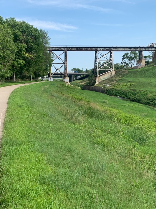
Omaha - Council Bluffs (NE-IA)
21 July 2023

My goals for my second full day in Omaha were simple and they began with breakfast and coffee. I rode my bike to Early Bird Brunch, where I found a very large burrito. Then I rode to to Bad Seed on Harney for coffee (second day in a row). It was the last good latte I would have in a long time.


My route included Creighton University and Downtown, but then headed south, eventually past the zoo (Omaha has a big one). Then it was across the river into Iowa and north on bike paths and roads through the Missouri bottomlands of Council Bluffs (the bluffs themselves remained well to the east). The bike route winds north past sports fields, industries, and a big casino, before reaching River’s Edge Park and the Bob Kerry Bridge back across the Missouri River into Omaha.

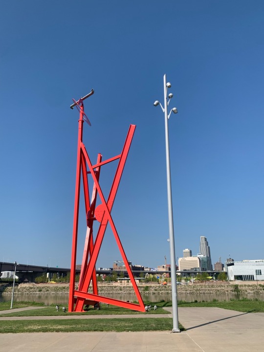
An interesting geopolitical detail: my ride began and ended in Iowa, even though I was on the west side of the Missouri. Carter Lake, where my airport hotel was located, is a disenfranchised oxbow of the Missouri that was abandoned in the 1870s, but which still remains part of Iowa.

5 notes
·
View notes
Text
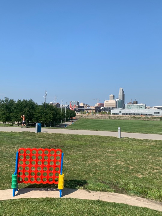
Omaha - Papillion (NE)
20 July 2023
I flew in on Wednesday, figuring I’d have a chance to unpack the bike, spend a couple of days acclimating to the heat and humidity, and maybe explore Omaha a little. My shuttle to Sioux City and the start of RAGBRAI wasn’t until Saturday morning.
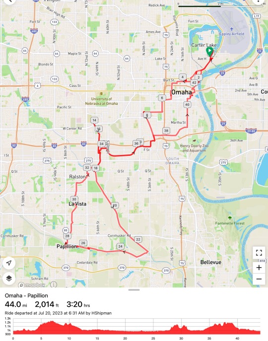

Thursday I’d hoped for a 40-50-mile ride and that’s what I needed up with, although the day began with doubts when I discovered that my rear brake line had picked up some air bubbles on the flight out and really needed to be fixed. It took a few stops along the way, but eventually I got pointed to a bike shop in Papillion which had the time and the skills to solve my problem. Thanks, Greenstreet Cycles.
Omaha has some nice bike trails, though as is often the case, sometimes the connections between them aren’t all that great. Riding downtown wasn’t too bad, in part because there simply wasn’t much traffic, but it took a while to find my way out to the more extensive trail network southwest of the city. Here, some long trails follow streams - now largely engineered flood channels - through broad greenbelts. The paths were great, though I didn’t find them terribly interesting. I’m probably spoiled by the geographic variety of Seattle.

2 notes
·
View notes
Text
Foothills Trail - Green River Loop
13 July 2023
This was a great 65-mile loop: good trail, mainly good roads, and a few rest stops. The uphill is generally railtrail and the biggest downhill comes in one fast curvy descent. The one thing I might do differently would be to pick a different spot to start and end the ride (maybe the Park’n’Ride in downtown Auburn near the train station?).
The ride began and ended on the Interurban Trail in Algona. There are a few options for trail parking, but the two I considered had no restrooms, which I consider an important attribute for an all-day ride with an hour of driving at each end. This stretch of the Interurban is okay, but it could really use some work - or even just a little attention. I was also a little frustrated with the lack of useful signage as the route zigzags south through Sumner, though it all worked out fine. My final gripe about this stretch is a harder one to solve and that’s figuring out how to link the Interurban, the Sumner Link, and the Foothills Trail through Puyallup better - this is a major regional trail and deserves a completely off-street route.
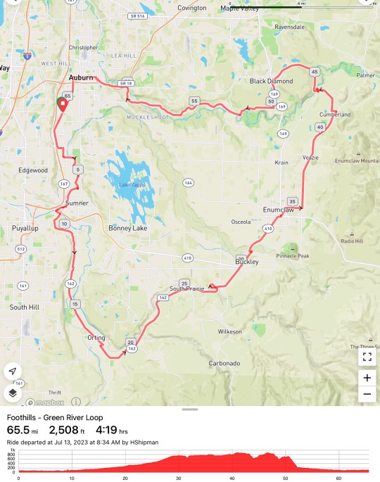

The Foothills Trail is great, despite today’s closure of a short section east of Orting that the Carbon River is trying to reclaim. I bypassed it on the main road, but I think the construction should be done by the end of the month. The Trailhead Cafe in South Prairie is a perfect stop for trail users. The trail would be even better if they could figure out how to get it across the White River between Buckley and Enumclaw (riders must currently use a short stretch of the highway).
The roads between Enumclaw and Black Diamond are good riding, as long as you’re willing to tolerate a little bit of traffic. And they’re relatively flat, except for the steep dip where the road crosses the Green River Gorge in Franklin. South of Black Diamond, you’re back on a busy road with good shoulders, though RWGPS routed me onto a tiny gravel side road (Plass Rd/257th Ave SE) which was sort of a nice diversion. The big drop into the Green River Valley comes around Mile 52 - but I think I saw no cars during the 5-10 minutes it took to descend. And then the Green Valley Road just meanders through the farmland almost to Auburn. Main Street takes one through downtown Auburn and back to the Interurban Trail.

5 notes
·
View notes
Text
Hurricane Ridge
6 July 2023
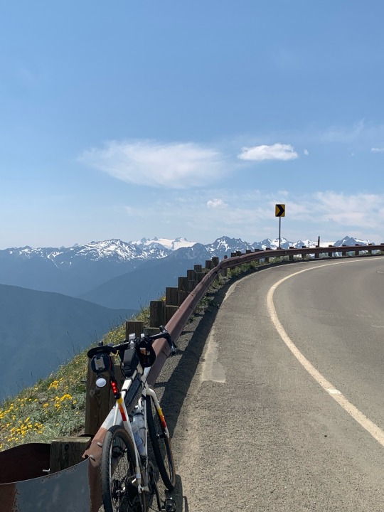
Hurricane Ridge is one of the longest paved climbs in Washington and I’ve wanted to ride it for a long time, but figured like other touristy destinations, it might be best done early in the season when it’s still closed to cars. This year in May, however, the summit visitors lodge burned to the ground (it was being renovated this year) and the Park Service is strictly limiting cars due to the lack of services, making it more appealing for bicycles. This came up in a coffee shop conversation with some local cyclists on Monday and on Thursday I headed for Port Angeles.
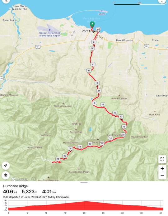
I parked at the waterfront and started up at 9:30. There were still cars being allowed up when I passed through the entrance station several miles up, but by 10:30 or so, the uphill flow stopped. By the time I got to the summit around 1:00 (it’s a long climb), there were only a few cars and shuttles. And on the wonderful ride back down (1:30 - 2:30) there were almost no cars at all (in either direction).

This is a pretty climb, but a desperately long one. The summit is 5200’ and one begins near sea level, which makes the ascent comparable to the main climb of Mount Lemmon in Tucson (but without the altitude). The grades are modest and the road surface is great. Most years, there would be food and water at the top. The views from Hurricane Ridge are always amazing.


There were half a dozen other cyclists on the route today. I never caught the couple who began ahead of me. I rode for several miles in the middle with a guy who caught up with me, but eventually it was clear that his pace was faster than mine. I like to think that since he was 75 he was simply more experienced than me!
I had toyed with idea of heading east on the gravel road to Obstruction Point, which sounds amazing, but it sounded like too much work.
5 notes
·
View notes
Text
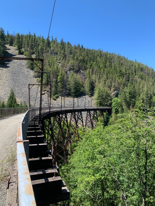
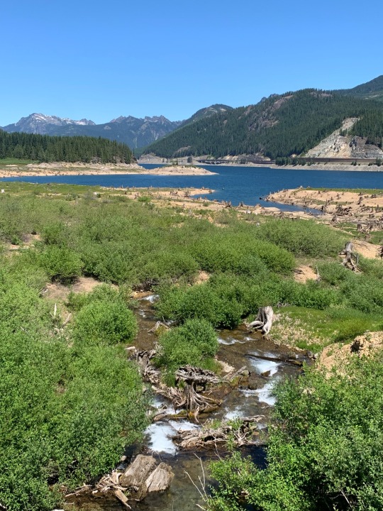
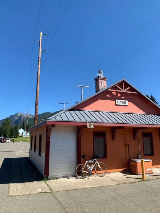
Snoqualmie Pass
2 July 2023

Today’s ride might have just been a simple 40-mile out and back, but I decided to throw in an additional loop that added 20 miles, including the only really hard climb of the day. I parked at Rattlesnake Lake/Cedar Falls and began pedaling around 8:00. I was back to the car by 2:30 and back to Seattle by 4:00, with a stop for a burger and a shake in North Bend.

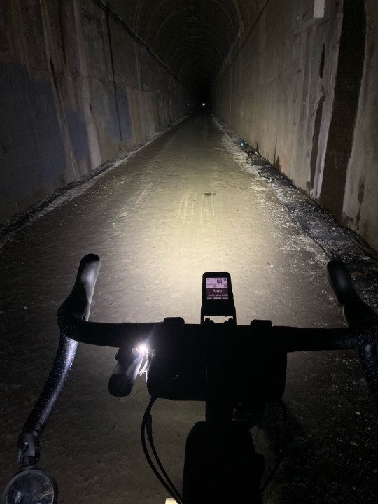
It’s 20 miles of easy railroad grade to the summit at Hyak, including the 2-mile tunnel at the top. I considered turning around and heading back, but opted instead to check out a new route (for me) around Lake Kacheelus to the east. I crossed I-90 to Gold Creek and then followed Forest Road 8432, which parallels (sort of) the interstate on the hillside north of the lake. It climbs steeply almost 1000’ toward the trailhead for Margaret and Lillian Lakes before eventually descending back down to the paved Kachess Lake Road. Then it’s back across the Interstate and a mile or so on the Stampede Pass Road before returning to the rail trail (10 miles east of Hyak).

Hyak was busy with families out walking or biking, many to the tunnel. The final 20-mile ride down from the pass was fast — 15-20 mph all the way on a gentle downhill grade on good dirt and gravel. There were plenty of other cyclists and hikers, but they were spread out and most of the time it was very quiet. There were the usual clusters of climbers on the cliffs at the trestles above Exit 38. The parking lot at the bottom had been pretty quiet in the morning, but cars were parked on the road for half a mile when I headed out (mainly for the lake and the hike to Rattlesnake Ledge, not for the rail trail).
This ride is a great reminder of now nice it is that the I-90 corridor has been kept fairly free from large scale development (Mountain to Sounds Greenway). The highway is never out of earshot, but it’s usually out of sight. It’s not wilderness, but it’s not bad, especially for being an hour from downtown.
I talked to a young guy at the bottom with a loaded bike. Turns out he was five days from La Push and eight weeks from his home in New York State. I always find it inspirational to chat with folks doing these long rides! It’s also a reminder that today’s ride was on the Great American Rail Trail, a somewhat aspirational concept since large segments remain incomplete or at least hard to ride, but the basic idea is that if you want to ride from coast to coast, this isn’t a bad route to take.

25 notes
·
View notes
Text
Quilcene Loop
26 June 2023

I’ve had ideas for rides in this corner of the Olympics for a long time, but it took a recent piece by Jan Heine on the Rene Herse Blog to spur my interest enough to get me out here. I picked up coffee, caught the ferry in Edmonds, and was pedaling from the Quilcene Ranger Station by 9:00. Despite what I was afraid might be a very long, grueling day of climbing, I was back to the car by 2:30. The total ascent was more than 5600’, but while the climbing was certainly hard, it was never painfully so. On the other hand, I was very happy to reach the final summit.
I rode the loop counterclockwise, which meant that the elevation ratcheted upwards in several separate climbs over more than 30 miles before the much quicker drop back to sea level at the end. The route crosses Bon Jon Pass at Mile 25, but the high point (3500’) comes later at Mile 32. All of the climbing was on gravel, while much of the descent was on pavement, which was my main rationale for doing the loop in this direction.


The downhill at the end was great, although it would have been greater had there not been an uphill segment half way down. Much of the descent is on a single-lane paved road (generally good surface, but with some big divots that require some caution), although there was an annoying section of fresh gravel near the bottom (which masked, but didn’t eliminate some nasty washboard). The final couple of miles are back on a regular two-lane road. This side would make a great climb if you simply wanted a stiff 1000+meter ascent without the longer loop (but that short gravel section would be tough on a road bike).
I saw almost no cars the entire ride. There were a few in the first and the last few miles, but that was about it, other than a few parked cars at trailheads. I stopped and chatted with one guy on an ATV who was hopelessly turned around - but I think I got him headed back in the right direction. It’s pretty easy to get lost back here. The roads aren’t marked well, the terrain is confusing, the trees are thick, and in the morning, clouds still obscured the sun. I was certainly grateful for having my route loaded on my GPS (I use RWGPS and a Wahoo Bolt) and for Gaia GPS which I use for offline maps on my phone (I also use a Garmin Messenger for tracking when I’m away from cell coverage).
The entire ride is in the trees, except for a few clear cuts and a couple borrow pits. I got a few glimpses of the surrounding hills and cliffs, occasional glimpses of Mount Townsend (the trailhead for which is near the high point of this route) and one view of Mount Constance(?) (with a large Texas camper van parked strategically in front), but it’s mainly just a lot of trees. Above 3000’, the rhododendrons start showing up in the understory.
The last time (the only other time) I was up here was in 2016 when I hiked up Mount Townsend (hshipman: Mount Townsend).

5 notes
·
View notes
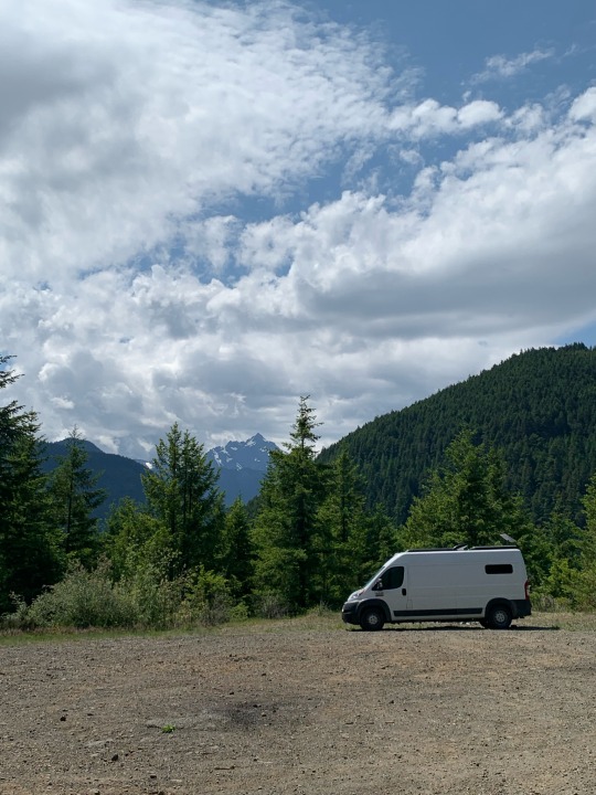
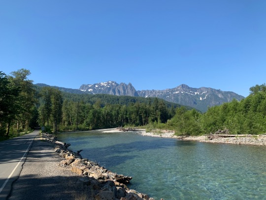
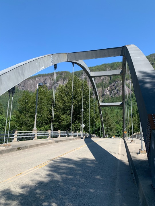
Text
Gold Bar to Index
23 June 2023
It’s less than an hour in the car from home to Gold Bar on US 2. There’s an easy place to park next to the railroad tracks and there’s a small store right across the street for last minute snacks. And May Creek and Reiter Roads provide a quiet alternative to the highway all the way to Index. But I’d never gone this way, either in the car or on the bike.
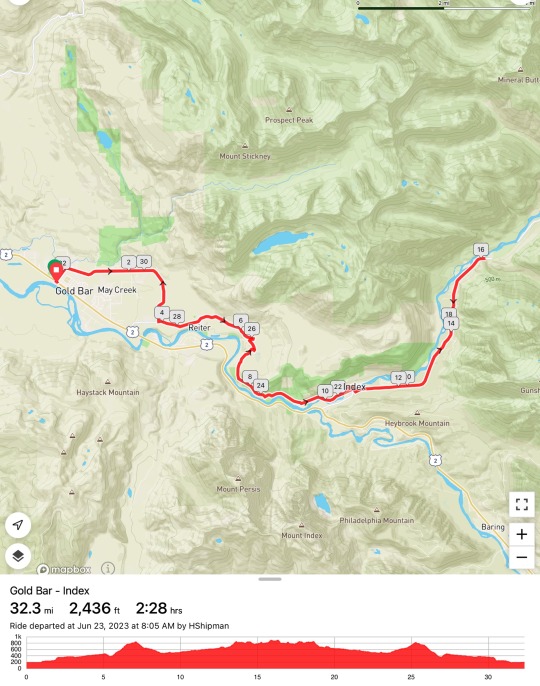


Reiter Road was great on the bike, with fairly good pavement and few cars. It does have a significant hill, in both directions, which breaks up the monotony of what otherwise would be a long, gradual climb up the Skykomish River. The road follows both the river and the railroad as it approaches Index. There were a couple of popular pullouts - probably mainly for climbers on the ‘Index Town Wall,’ the cliffs on the north side of the valley.
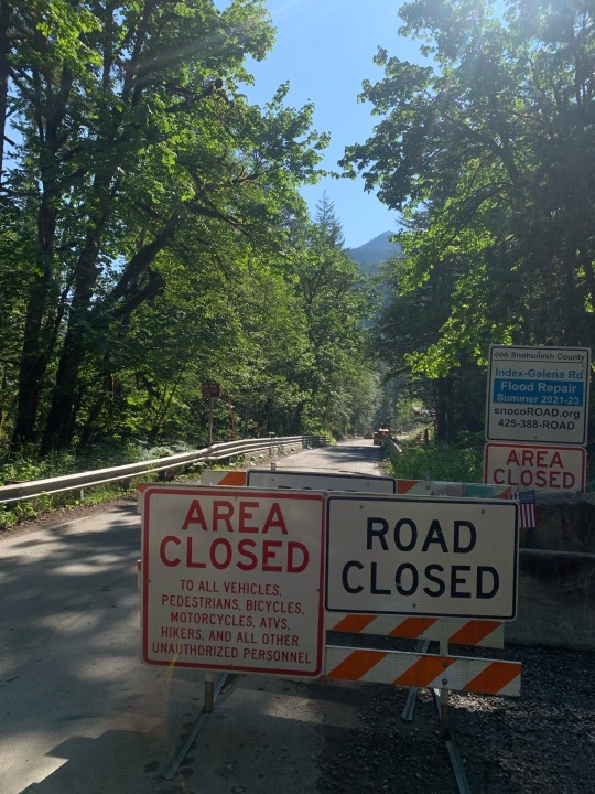
Index itself, completely overlooked by folks driving on Route 2, has a park, a store, and a restaurant or two. It makes a good break before turning around, or heading on up the North Fork of the Skykomish.
I rode another five miles above Index on the Index-Galena road, but turned around when I reached the construction barriers. There were big washouts back in 2006 and the county is finally getting close to reopening the road, but for the time being, this is the end of the line.

It’s too bad there aren’t more alternatives like Reiter Road for the rest of US 2 across the mountains. There are a few bike friendly options - the old road on the west side of Steven’s Pass, for example. But there are also places where the only choice is the busy highway, and while some sections have wide shoulders, many do not. If this could be solved, this could become a wonderful way to cross the Cascades by bike.

0 notes
Text
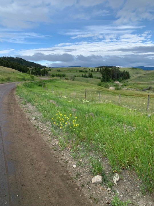
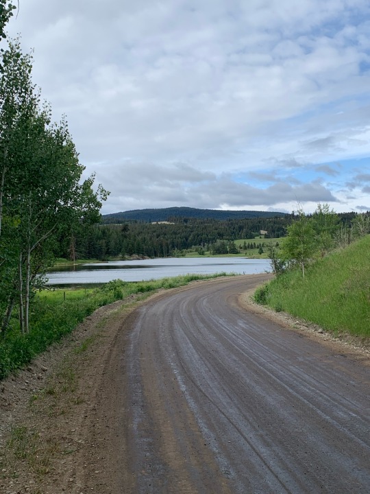
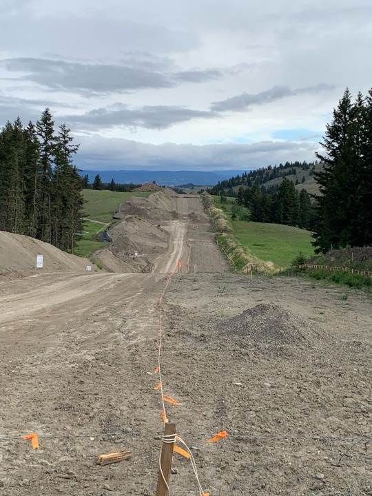
Kamloops - Goose Lake Loop (BC)
18 June 2023

We spent the last night of our trip in a hotel on the main highway and I spent the evening looking online at possible rides for the next morning. This turned out to be a great choice given where we were staying. I considered expanding the route to include downtown and the river, but that would have added an awful lot of climbing to a ride that already had plenty.
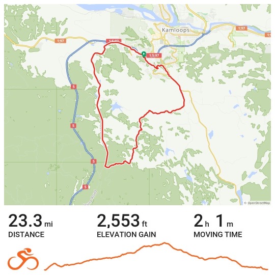
The first leg was a short, steep climb through suburbia. The second leg was a long, gradual climb on Long Lake (paved) and Goose Lake (gravel) Roads. And the final leg was a fast downhill (mostly downhill) on Lac Le Juene Road towards Kamloops. It was Sunday morning and there was very little traffic anywhere.
Goose Lake Road crosses the TransMountain pipeline corridor, and while there were crews working in places, the huge construction project didn’t interfere with the ride. The route crosses the pipeline again where the corridor crosses the TransCanada Highway near the end of my loop. The ride provided some time to ponder the logistical and financial challenges of huge infrastructure projects, the tradeoffs inherent in improving petroleum distribution in a world moving away from carbon, the visual and environmental realities of corridor-style construction in rural and natural landscapes, and the regional politics of a controversial initiative.
2 notes
·
View notes