pharology101
Pharology101
Just a blog dedicated to lighthouses. There will be daily posts, maybe one or two depending on my mood.
Oh, and if you see 'kirby42280' follow you, that's my main blog.
3321 posts
Don't wanna be here? Send us removal request.
Last Seen Blogs

cinemaforlife
Film journal

insyohair
中山 口コミ評判な美容室iNSYO hair lounge

houseofevil
The House Of Evil

tsuki-bond
𝕊𝕡𝕖𝕝𝕝𝕓𝕠𝕦𝕟𝕕 𝔽𝕠𝕠𝕝
Text
LOTD: Canal de Chavarria
(from: https://www.ibiblio.org/lighthouse/mxtm.htm)
Canal de Chavarria (Barra Morón) (2)
2012. Active; focal plane 10 m (33 ft); white flash every 5 s. 7 m (23 ft) round cylindrical concrete tower with gallery, painted white with blue trim. No photo available but Google has a satellite view of the station. Located on the north side of a dredged lagoon entrance at Barra Morón. Accessible only by boat. Site open, tower closed. Active light: CF-28-098; Admiralty J4232.5; NGA 15213.
(sorry - no photo available)
0 notes
Text
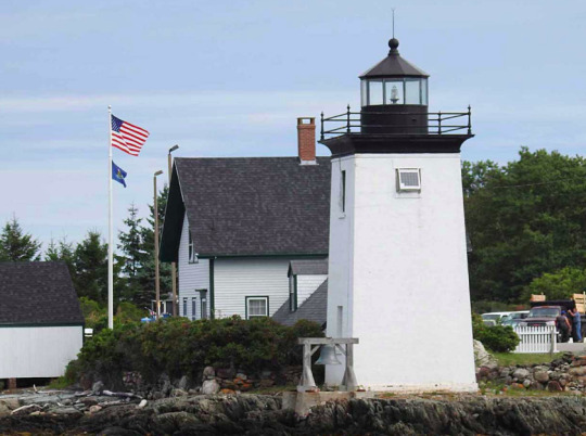
LOTD: Crabtree Ledge
(from: https://www.lighthousefriends.com/light.asp?ID=1864)
Crabtree Ledge, Maine (Timeline)
1887 – Crabtree Ledge, in Frenchman's Bay, Maine.—This ledge, upon which there are from 8 to 12 feet of water at mean low tide, was surveyed, title to the site, with jurisdiction, was secured from the state of Maine, and drawings, specifications, and estimates for the lighthouse were prepared.
1888 – Crabtree Ledge, Frenchman's Bay, Maine.— On August 4,1886, Congress appropriated $25,000 for the erection of a light-house at this place. The Board designed an appropriate structure for this location and advertised for proposals for furnishing the metal-work and for its erection. The bids received showed that the amount appropriated was insufficient for the erection of the proper structure at this location, and the Board therefore obtained an appropriation of the additional $13,000 necessary for the erection of this light house. The work will now be undertaken at the earliest date practicable.
1889 – Crabtree Ledge, about 1 ½ miles south of Mount Desert Ferry, Maine.— Contracts were made for the metal work, for the cement, and for the erection of the light-house. Part of the metal work and of the cement were delivered at Mount Desert Ferry. The location of the foundation cylinder was fixed upon the ledge, and the building of a crib-pier around it was commenced.
1890 – Crabtree's Ledge, Frenchman's Bay, Maine.—A fifth-order light, January 15, 1890.
1890 – Crabtree's Ledge, between Bar Harbor and Mount Desert Ferry, Frenchman's Bay, Maine.—The light-house recently constructed consists of a cylindrical iron caisson, 25 feet in diameter and 32 feet in height, founded upon a rock 15 feet below mean sea-level. It is filled with concrete and surmounted by an iron tower, 37 feet high from base to focal plane, and was finished December 31, 1889. A fixed white light of the fifth order, varied by a white flash every two minutes, illuminates the whole horizon, and was first exhibited on January 15, 1890.
1891 – Crabtree Ledge, Frenchman Bay, Maine.—A bell struck by machinery, August 1, 1890.
1891 – Crabtree Ledge, between Bar Harbor and Mount Desert Ferry, Frenchman Bay, Maine.—A 1,200-pound bell, struck by machinery, with a bell house of sheet iron, was placed upon the pier. Various minor repairs were made.
1895 – Crabtree Ledge, Frenchman Bay, Maine.—A landing ladder was made and fitted. Various repairs were made.
1903 – Crabtree Ledge, on Crabtree Ledge, Frenchman Bay, Maine.— The color of the tower was changed from brown to white, and the revolving clock and fog-bell machinery repaired.
1913 – J. H. Peasley, keeper, rendered assistance to Arthur L. Bunker in danger of drowning.
1914 – Jerome H. Peasley, keeper, rendered assistance in getting schooner-yacht White Wings off rocks near station.
1916 – J.H. Peasley, keeper, towed disabled motor boat with 1 man on board to shore.
1916 – October 2. Assistant Keeper Chester Brinkworth, 31, and his brother Charles [Arthur Leon], 27 [20], were drowned Saturday near Crabtree Ledge Lighthouse at the entrance to Sullivan Harbor, according to information received here today at the Lighthouse Department. Capt. Sherman went with the lighthouse tender Hibiscus to search for the bodies.
Charles Brinkworth fell from a dory, and his brother sprang overboard to rescue him, both perishing. Jerome C. Peaslee, keeper of the light, was ill, and his assistant, Chester Brinkworth, had gone ashore to bring back his brother as helper. The two were lost on the return trip.
Chester Brinkworth’s body and the capsized dory were found by the Hibiscus, which is searching for the body of Chester’s brother. The latter has left his home at Hancock Point in the face of a heavy wind and high seas. Friends advised against his making the trip, but young Brinkworrh said that, with the keeper in a hospital, his brother would be lonely.
1917 – March 21. Captain Joseph Whitmore, assistant keeper of Crabtree ledge light, was drowned by the capsizing of a boat in which he was returning to his post from Ellsworth, Me.
1933 – Crabtree Ledge Lighthouse discontinued.
1934 – Sold to a group of yachtsmen for $105.
1950 – Crabtree Ledge Lighthouse collapsed during a winter storm.
Keepers:
Head: Amaziah R. Small (1889 – 1898), Charles F. Chester (1898 – 1911), Jerome H. Peasley (1911 – at least 1917), Clarendon G. Hurd (at least 1919 – 1920), Ora S. Jordan (1920 – at least 1921), Thomas H. Morgan (at least 1926 – 1933).
Assistant: Francis T. Hodgkins (1893), Charles F. Chester (1893 – 1898), Joseph M. Gray (1898 – 1900), Rollins E. Dobbin (1900 – 1902), Frederick W. Morong, Jr. (1902), Charles W. Thurston (1902 – 1909), Jerome H. Peasley (1909 – 1911), A. R. Leeman (1911), Frank C. Crowley (1911 – at least 1912), Maurice R. Beal (at least 1913), Chester D. Brinkworth (1914 – 1916), Joseph Whitmore ( – 1917), F.N. Foss (at least 1917), Thomas H. Morgan (at least 1919 – at least 1924), Vassar L. Quimby (1926 – 1933).

(historic photo found from above listed website - actual source unknown)
0 notes
Text
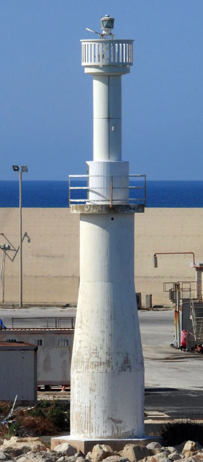
LOTD: Scaramia
(from: https://www.ibiblio.org/lighthouse/sic.htm)
Scaramia (Capo Scalambri, Punta Secca)
Date unknown (station established 1859). Active; focal plane 37 m (121 ft); two long (1.5 s) white flashes every 8 s. 34.5 m (113 ft) round tower with lantern and gallery. Lighthouse painted white; lantern dome is gray metallic. Pippo Palazzolo has posted an excellent photo, Trabas has Arno Siering's closeup photo, Wikimedia has a good photo, Kristina Mihailyus has a 2018 photo, a 2008 photo is available, Marinas.com has aerial photos, and Google has a street view and a satellite view. Located adjacent to the small harbor of Punta Secca, about 25 km (15 mi) southwest of Ragusa and 5 km (3 mi) west of Marina di Ragusa. Site open, tower closed. . ARLHS ITA-042; EF-2942; Admiralty E1896; NGA 10184.
(full photo found here; ©Pippo Palazzolo)
0 notes
Text
LOTD: Penedo da Saudade
(from: https://www.ibiblio.org/lighthouse/prtc.htm)
Penedo da Saudade
1912. Active; focal plane 55 m (180 ft); two white flashes every 15 s. 32 m (105 ft) square masonry tower with lantern and gallery, attached to a 2-story brick keeper's complex. 3rd order Fresnel lens. Trabas has Meyer's closeup photo, Jose Carlos Gago has a 2021 photo, Noemia Costa Dias has a nice closeup, Marinas.com has aerial photos, Huelse has a historic postcard view, Google has a good street view, and Google has a satellite view. This lighthouse does not mark a prominent cape; it was located at a convenient point halfway between the lights of Cabo Mondego and Ilha Berlenga. The original 3rd order lens was transferred to Cabo Mondego in 1921, but it was replaced by another 3rd order lens of a different type. The lighthouse and keeper's house were both renovated and restored in 1997-98. A penedo is a boulder, in this case a huge rock in the sea in front of the lighthouse. Located directly on the coastal road about 800 m (1/2 mi) north of São Pedro de Moel. Streetside parking is available. Site open, lighthouse open on Wednesday afternoons. . ARLHS POR-034; PT-117; Admiralty D2072; NGA 3312.

(photo found here; ©RomainD.C)
1 note
·
View note
Text
LOTD: Sgat Mòr
(from: https://www.ibiblio.org/lighthouse/sctw.htm)
Sgat Mòr (2)
Date unknown (station established 1923). Active; focal plane 9 m (30 ft); white flash every 3 s. 8 m (26 ft) round cylindrical white steel tower with lantern. This lighthouse marks the east side of the entrance to Loch Fyne from the Sound of Bute. Gordon Brown has a photo, a closeup is available, Trabas has a distant view, Marinas.com has aerial photos, and Google has a satellite view. The body of the lighthouse is a former propane tank, but the light is now solar-powered. Located on a small island off the point of Rubha Stillaig about 3 km (2 mi) south of Portavadie. Accessible only by boat (or sea kayak). Site open, tower closed. Operator: unknown. ARLHS SCO-353; Admiralty A4296; NGA 4276.

(full photo found here; ©Gordon Brown)
0 notes
Text
LOTD: Tombua
(from: https://www.ibiblio.org/lighthouse/ago.htm)
Tombua (Tombwa, Porto Alexandre) (2?)
Date unknown (1920s or early 1930s). Active (?); focal plane 11 m (36 ft); white or green light, depending on direction, occulting three times every 9 s. 8 m (26 ft) tripod skeletal tower mounted atop a 1-story building. No photo available but Google has an indistinct satellite view. This is one of several lights in Namibe reported to have been rehabilitated in 2008; the satellite view suggests that the light was moved to a skeletal tower next to the building. Located at the end of a sand spit protecting the harbor of Tombua (called Porto Alexandre under colonial rule), marking the west side of the harbor entrance. Site status unknown. PT-5606; Admiralty D5436; NGA 25716.
(sorry - no photo available)
0 notes
Text
LOTD: Momi Bay Range Front
(from: https://www.ibiblio.org/lighthouse/fji.htm)
Momi Bay Range Front (2)
2012 (station established 1911). Active; focal plane 10 m (33 ft); quick-flashing white light. 12 m (39 ft) light mounted on a round platform supported by three concrete piles. The tower carries a daymark painted red with a white vertical stripe. A closeup photo is available and Google has a satellite view. This is an entrance range for the Navula Reef pass, which leads ultimately to Nadi. In 2012 the light was relocated on a new structure; Google also has a satellite view showing the original platform, about 200 m (220 yd) to the west. Located at the water's edge in Momi Bay, about 8 km (5 mi) northeast of the Navula Reef light. Accessible only by boat. Site open, tower closed. ARLHS FIJ-006; Admiralty K4704; NGA 3432.

(photo found here; ©unknown)
0 notes
Text
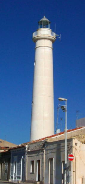
LOTD: Punta Jerez (2)
(from: https://www.ibiblio.org/lighthouse/mxtm.htm)
Punta Jerez (2)
Early 1990s (station established 1904). Active; focal plane 24 m (79 ft); white flash every 6 s. 20 m (66 ft) cylindrical concrete tower with four buttresses, lantern and gallery. Lighthouse painted white; the gallery is blue. Two modern keeper's cottages. A 2015 photo is available, Alejandro Aguilar has a 2019 photo, and Google has a satellite view. The new light station is located on the mainland about 650 m (0.4 mi) west of the original location. Accessible by 4WD. Site open, tower closed. ARLHS MEX-058; CF-28-100; Admiralty J4232; NGA 15212.
(full photo found here; ©Alejandro Aguilar)
0 notes
Text
LOTD: Burnt Coat Harbor Range Front
~sorry for delay - meant for December 15th, 2023~
Burnt Coat Harbor Range Front
(1872-1883), Swans Island. This tower was demolished after being deactivated. ARLHS USA-1093.

(Historic photo found here, but courtesy of US National Archives. The range light is on the right side of this picture.)
0 notes
Text
LOTD: Marina di Ragusa
~sorry for delay - meant for December 14th, 2023~
(from: https://www.ibiblio.org/lighthouse/sic.htm)
Marina di Ragusa (Sulla Spiaggia)
Date unknown. Active; focal plane 12 m (39 ft); red flash every 5 s. 12 m (39 ft) square cylindrical masonry tower with lantern and gallery. Lighthouse painted white; lantern is gray metallic. Trabas has Arno Siering's photo, Massimiliano Zacco has a photo, Andreas Köhler has a photo, Giuseppe Scalici has a street view from the beach, and Google has a satellite view. Located across the street from the base of the east breakwater of Marina di Ragusa, about 6 km (4 mi) east of Punta Secca. Site open, tower closed. ARLHS ITA-223; EF-2941; Admiralty E1894; NGA 10188.

(full photo found here; ©Arno Siering)
0 notes
Text
LOTD: Nazare
~sorry for delay - meant for December 13th, 2023~
(from: https://www.ibiblio.org/lighthouse/prtc.htm)
Nazaré (Forte de São Miguel)
1903. Active; focal plane 50 m (164 ft); white light, 2 s on, 1 s off. 8 m (26 ft) round cast iron (?) lantern mounted on the wall of the fort. Lantern painted bright red. Fog siren (one 10 s blast every 35 s). Jean-Michel Brunet's photo is at right, Trabas has a good photo, Carlos Olmo Bosco has a closeup of the lantern, Piotr Zawiła has a 2022 photo, and Google has a street view and a satellite view. This light is built on the stone walls of the Forte de São Miguel, which dates from 1577. This location is famous among surfers for its extremely high waves; spectators gather around the lighthouse to watch and the lighthouse is often seen in TV coverage. Located on a very sharp headland at the west end of the town of Nazaré, a village now popular as a beach resort. Site open, fort open. . ARLHS POR-032; Admiralty D2074; NGA 3316.

(full photo found here; ©Piotr Zawiła)
1 note
·
View note
Text
LOTD: Caladh
~sorry for delay - meant for December 12th, 2023~
(from: https://www.ibiblio.org/lighthouse/sctw.htm)
Caladh (Kyles of Bute)
1888. Obviously inactive as a lighthouse for many years but charted as a daybeacon. Approx. 8 m (26 ft) round masonry tower with a window at thes top through which the light could be displayed. Lightphotos.net has a closeup photo, Wikimedia has a photo, and Google has a satellite view. Newman rediscovered this largely forgotten lighthouse in April 2002 but we need information on its history. Located on the west side of the entrance to Loch Riddon about 4 km (2.5 mi) northeast of Tighnabruaich, not far off the A8003 highway. Site open, tower closed. Owner/site manager: unknown. ARLHS SCO-304.

(full photo found here on Wikipedia)
0 notes
Text
LOTD: Ponta Albina
~sorry for delay - meant for December 11th, 2023~
(from: https://www.ibiblio.org/lighthouse/ago.htm)
Ponta Albina (4?)
Around 2010 (station established 1920s). Active; focal plane 35 m (115 ft); two white flashes every 10 s. 38 m (124 ft) square skeletal tower with lantern and gallery. Lighthouse painted white. No photo available but Google has a satellite view. Earlier Google satellite views showed that the previous lighthouse, a similar tower mounted on a 1-story keeper's house, had been destroyed. The earlier lighthouse was a sibling of the second Ponta dos Palmeirin has lighthouse. Located on a prominent point of land about 25 km (15 mi) southwest of Tombua. Site status unknown. ARLHS ANO-011; PT-5612; Admiralty D5442; NGA 25720.
(sorry - no photo available)
0 notes
Text
LOTD: Navula Passage
~sorry for delay - meant for December 10th, 2023~
(from: https://www.ibiblio.org/lighthouse/fji.htm)
Navula Passage (2?)
Date unknown. Active; focal plane 11 m (36 ft); green flash every 3 s. 11 m (36 ft) post rising from a round concrete tower mounted on a round platform supported by three piles. Trabas has Hartmann's photo and Google has a satellite view. Located at the north end of the reef opposite the Navula Reef lighthouse. Accessible only by boat. Site open, tower closed. Admiralty K4703.

(full photo found here; ©Hartmann)
0 notes
Text
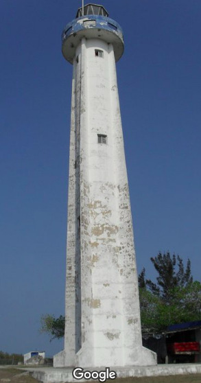
LOTD: Punta Jerez (1)
~sorry for delay - meant for December 9th, 2023~
(from: https://www.ibiblio.org/lighthouse/mxtm.htm)
Punta Jerez (1)
1904. Inactive since the early 1990s and destroyed in 2000. This lighthouse, a round French cast iron tower with ribs or buttresses, collapsed during Hurricane Keith in October 2000. Lighthouse Digest has a small photo by Hector de Luna Espinosa. A 2006 photo (no longer online) showed a single buttress still standing. Ruins of the keeper's houses also survive, as seen in Abimael Silva's 2022 photo and Google's satellite view. Punta Jerez, about 70 km (45 mi) north of Tampico, is not a cape but only a subtle bend in the barrier beach. The abandoned light station is located on the beach. Accessible only by boat. Site open.
(sorry - no photo available)
0 notes
Text
LOTD: Grindle Point
~sorry for delay - meant for December 8th, 2023~
(from: https://www.ibiblio.org/lighthouse/me.htm)
Grindle Point (2)
1874 (station established 1851). Reactivated (inactive 1934-1987); focal plane 39 ft (12 m); green flash every 4 s. 39 ft (12 m) square brick tower with lantern and gallery, attached by a covered passageway to the original 1-1/2 story wood keeper's house; solar-powered 250 mm lens (1987). Tower painted white, lantern and gallery black. Brick oil house (1906). Trabas has Boucher's closeup photo, Robert English has a good 2007 photo, Anderson has a good page with several photos, Marinas.com has aerial photos, Huelse has a historic postcard view, and Google has a satellite view. The town of Isleboro bought the station for $1200 when it was deactivated in 1934 and put the keeper's house in use as the Sailor's Memorial Museum in 1938. A fog bell similar to the original is on display. In 1987, after many requests, the Coast Guard returned the light to the tower. Located on the southeast side of Islesboro Island at the entrance to Gilkey Harbor. The island is accessible by state ferry from Lincolnville, and the light station is adjacent to the ferry terminal. Site open, museum open daily except Mondays July 1 through Labor Day (early September), tower closed. Operator: U.S. Coast Guard. Owner/site manager: Town of Islesboro (Grindle Point Sailor's Museum and Lighthouse). ARLHS USA-356; Admiralty J0090; USCG 1-4405.
(full photo found here; ©Boucher)
0 notes
Text
LOTD: Pozzallo Porto Commerciale
~sorry for delay - meant for December 7th, 2023~
(from: https://www.ibiblio.org/lighthouse/sic.htm)
Pozzallo Porto Commerciale
2011. Active; focal plane 18 m (59 ft); four white flashes every 12 s. 15 m (49 ft) round tapered 2-stage tower with double gallery; the lower stage is concrete and the upper stage is fiberglass. Entire lighthouse is white. Trabas has Capt. Peter's photo and Google has a satellite view. Located at the elbow of the main breakwater of Pozzallo. Site status unknown, but the tower can be seen from the waterfront and from ferries sailing between Pozzallo and Malta. EF-2934; Admiralty E1889.05; NGA 10196.
(full photo found here; ©Capt. Peter)
0 notes