#Caribbean Coastal Area Management Foundation
Text
King Willem-Alexander, Queen Máxima and Princess of Orange will visit to Caribbean part of the Kingdom – programme
His Majesty King Willem-Alexander, Her Majesty Queen Máxima and Her Royal Highness Catharina-Amalia, Princess of Orange, will pay a visit to the Caribbean part of the Kingdom of the Netherlands from Friday 27 January to Thursday 9 February 2023. They will visit Bonaire, Aruba and Curaçao before continuing to St Maarten, St Eustatius and Saba. The visit is intended to introduce the Princess of Orange to the Caribbean part of the Kingdom. The islands have put together a programme covering such topics as culture, nature, colonial history, sports and defence operations, and including meetings with island residents. The royal party will be accompanied by State Secretary for Kingdom Relations and Digitalisation Alexandra van Huffelen.
Bonaire, Friday 27 to Saturday 28 January
The royal party will arrive in Bonaire on Friday afternoon, where they will be welcomed by Governor Edison Rijna. On Saturday morning the governor will receive the party at his official residence, together with members of the island council and island executive.
The King and Queen and the Princess of Orange will then visit the slave huts at Witte Pan, which are reminders of the history of slavery in Bonaire. Following this they will travel along the west coast and attend Nos Zjilea at Cultural Park Mangazina di Rei, an event which highlights Bonaire’s cultural and historical heritage. The party will view an exhibition on the island’s history. Young people will tell them about their local area, a family of four generations will bake bread in a stone oven and primary school children will perform with their learning orchestra. This will be followed by a lunch with Bonaire residents at Arawak.
In the afternoon the party will watch a windsurfing demonstration in Sorobon Bay. Bonaire is reputed for its good windsurfing and the talented windsurfers it produces. The King and Queen and the Princess of Orange will then talk to junior rangers from the STINAPA national park foundation about coastal nature conservation, especially of the mangroves which protect the coast. The party will tour the bay and mangroves by boat.
The visit to Bonaire will draw to a close in Kralendijk with a trip to Taste of Bonaire, a cultural market with local products, culinary offerings and musical performances.
Aruba, Monday 30 January
On Monday morning the King and Queen and the Princess of Orange will arrive in Oranjestad, where a welcome ceremony will take place on Wilhelmina Square. Following a meeting with Governor Alfsonso Boekhoudt, the party will walk to the parliament to speak with party leaders. They will then walk to the Cocolishi building, which houses Aruba’s cabinet. There they will have lunch with the prime minister and ministers. On the way they will interact with members of the public and see performances by a local learning orchestra and youth choir.
In the afternoon the party will continue to San Nicolas, a town with an artistic vibe. At Filomena College secondary school they will attend a performance about Boy Ecury, an Aruban-Dutch resistance hero. This will take place next to a mural dedicated to him. Other colourful murals, created by local and international artists during Aruba Art Fair, will be highlighted during a walk through the town. The party will also pay a brief visit to the Museum of Industry and will watch street performances by young people, featuring breakdance, spoken word and a carnival show.
Aruba, Tuesday 31 January
In the morning the King and Queen and the Princess of Orange will visit Arikok National Park. This protected area covers 20% of Aruba. The party will go on a hike in the park, meet the makers of a nature documentary about the six islands and discuss nature conservation and management with junior rangers at the Center of Cultivation. The royal party will then continue on to Royal Aruba Aloe, a company founded in 1890, where they will speak with staff and see how the company cultivates aloe vera and uses it in making skincare products.
In the afternoon the party will visit the University of Aruba. They will attend part of a lecture on Caribbean law and talk with students. The King and Princess of Orange will then visit the Soccer Academy at Compleho Deportivo Frans Figaroa, which provides training for talented young people in collaboration with the Royal Netherlands Football Association (KNVB). Queen Máxima will pay a field visit to a vegetable farmer who attends a business academy run by credit provider Qredits.
In the evening the Bon Bini Festival will take place at Fort Zoutman. Following a walk around Plaza Padú, where there will be music and a presentation of local products, the royal party will watch an exploratory show on Aruban culture and history, with Caribbean music and dance.
Aruba/Curaçao, Wednesday 1 February
The King and Queen and the Princess of Orange will sail from Aruba to Curaçao on patrol ship HNLMS Holland, which is stationed in the Caribbean part of the Kingdom. On board they will discuss the Ministry of Defence’s operations in the Caribbean region, followed by a tour of the vessel and demonstrations. The Defence organisation works to keep all parts of the Kingdom safe. Military units stationed in the region fulfil three key tasks: to protect the Kingdom’s territorial integrity, to promote and maintain the international legal order, and to support the local authorities. For example, they carry out operations to counter drug smuggling, provide assistance in sea rescues and provide emergency relief after hurricanes.
Upon arrival in Willemstad’s St Anna Bay the royal party will be greeted by Governor Lucille George-Wout. This will be followed by a welcome ceremony marking the start of their visit to Curaçao.
Curaçao, Thursday 2 February
The visit to Curaçao will commence in Willemstad with a walk over the Queen Emma Bridge to Brión Square, where the King will give the starting signal for registration for the King’s Games. Primary school children will take part in sports contests on the square. Afterwards the party will tour the Otrobanda district, talking to residents and artists and watching musical performances. This will be followed by a lunch with representatives of the Curaçaoan authorities in the Governor’s Palace.
In the afternoon the royal party will visit the Punda and Scharloo districts. In Punda the King will strike a coin to mark the 25th anniversary of Willemstad becoming a UNESCO World Heritage site. The party will also paint a chichi, a traditional Curaçaoan sculpture symbolising the responsible eldest sister in a family. They will then go on a walk through the Scharloo district, with street art, music and youth sports projects. The walking tour will end at Princess Amalia Bridge, where the party will listen to Amalia Waltz, a piece composed for the Princess.
In the evening a dinner will be held at the Cathedral of Thorns, attended by 21 residents who make a valuable contribution to their community. The number of guests reflects the fact that it is the royal couple’s 21st wedding anniversary on that day.
Curaçao, Friday 3 February
In the morning the royal party will visit the Tula Museum at Landhuis Knip on the former plantation where Tula started a slave revolt in 1795. They will watch a performance about the revolt and speak with descendants of enslaved people. They will then visit Hofi Mango, a former sugar plantation that is now a nature park where, among other things, horticultural education is provided.
In the afternoon the King and Queen and the Princess of Orange will attend a presentation on Cas Abao beach by Sea Turtle Conservation Curaçao and the Dutch Caribbean Nature Alliance (DCNA) about protected marine areas and preserving the sea turtle population.
The trip to Curaçao will conclude with a visit to a Tumba Music Concert with carnival acts at Brión Square. The concert is being held in honour of the late Boy Dap, who is regarded as the king of Tumba, a genre of music and dance originating in Africa.
St Maarten, Monday 6 February
The King and Queen and the Princess of Orange will be welcomed at Princess Juliana International Airport by the Governor of St Maarten Ajamu Baly and Prime Minister Silveria Jacobs. The first day of the visit will focus on the country’s reconstruction following the devastation caused by hurricane Irma in September 2017. The royal party will view the airport which is currently still being rebuilt. During a visit to the emergency and disaster response services, the King and Queen and the Princess of Orange will assist in a disaster exercise. They will then visit the St Maarten Medical Center. This hospital plays a key role in the region and also treats many patients from St Eustatius and Saba. The King, Queen and Princess will speak to patients and will be updated on the expansion of the hospital. They will then have lunch with the cabinet.
In the afternoon the royal party will be taken on the Color Me SXM mural walk in Philipsburg. These murals are designed to brighten up Philipsburg, as many of the town’s buildings are still vacant or damaged following the hurricane. The day will conclude with lively displays of St Maarten’s culture along a walking route and a concert on the Boardwalk in Philipsburg.
St Maarten, Tuesday 7 February
In the morning the King and Queen and the Princess of Orange will visit Fort Amsterdam. Here they will go on a birding excursion in search of the brown pelican, the island’s national bird. They will also learn about the fort’s history. They will then meet members of St Maarten’s parliament and youth parliament. At the White and Yellow Cross residential home for older people and people with a disability, the royal party will learn more about the daytime activities organised for residents. Next, they will visit a science fair, where primary and secondary school pupils will present their solutions for reducing plastic waste on the island.
In the afternoon the King and Queen and the Princess of Orange will visit Resources for Community Resilience (R4CR). R4CR disburses World Bank funds to projects aimed at rebuilding St Maarten after hurricane Irma via a Trust Fund. The party will speak with representatives of civil society organisations about their projects and with young people about their work at various organisations. They will then visit a school garden project where they will talk to pupils about their work in the garden and the importance of gardening for their mental health. In Emilio Wilson Park schoolchildren will talk about their dreams for the future of St Maarten and plant yellow sage, the island’s national flower. Following this the King and Queen and the Princess of Orange will visit St Peters Hill, where they will learn about nature conservation in St Maarten. This hill borders on the French part of the island. The afternoon will conclude with a youth baseball tournament.
In the evening the party will attend a reception hosted by the governor.
St Eustatius, Wednesday 8 February
The royal party will be welcomed to St Eustatius by Government Commissioner Alida Francis and will meet representatives of the island’s authorities. During a walk through Oranjestad’s historical centre they will meet a number of Statia residents who will speak about their life on the island. The history of slavery on the island will also be discussed. After the walk, the King and Queen and the Princess of Orange will attend a debate with young people about their future on the island.
After a lunch with island residents, the royal party will go to Zeelandia Beach where they will hear about local nature management and the annual STATIA DOET Beach Clean Up. After this they will visit a community garden, where they will speak with farmers about the food system on the island. Because a lot of food is imported, prices are high and there is a shortage of fresh produce. The party will then join schoolchildren in a basketball practice session. The visit to St Eustatius will conclude with an event at Fort Oranje, focusing on the island’s cultural heritage.
Saba, Thursday 9 February
The royal visit will conclude on Saba. After being received by Island Governor Jonathan Johnson, the King and Queen and the Princess of Orange will hear about Saba’s energy supply. Saba aspires to become energy neutral within the next few years. The royal party will then proceed to the village of Zion’s Hill for a presentation on lacemaking, a Saban tradition. On a walk through the village of Windwardside the King and Queen and the Princess with meet local residents. At the Eugenius Center they will meet older residents who will also give a theatre performance. The party also speak with artists and business owners about their work. The party will also step into the Harry L. Johnson Museum where they will learn about life on Saba through the years.
After a lunch with representatives of the Saban authorities, the royal party will visit the Expertise Center Education Care (EC2) in St Johns, that supports vulnerable schoolchildren. The organisation won an Orange Fund ‘Appeltje van Oranje’ award in 2021. The party will then depart for the harbour, where they will find out more about Saba’s new harbour project. Scientists will tell them about a project on Diadema sea urchins, which help protect coral reefs by eating the algae that would otherwise overrun the coral. The final component of the programme will see the King and Queen and the Princess of Orange visit The Bottom where they will play sports with children on the world’s largest Cruyff Court.
14 notes
·
View notes
Text
It’s Always Grand On The Hyatt DFW
Cairns, in north Queensland, is known for providing stunning wedding ceremony locations within a laid back, relaxed environment. Complementing the Green Leaf hotel in Niseko Village is the 500-room Hilton Hotel close by, additionally owned by YTL Hotels, and right subsequent to the Niseko Ski Gondola offering direct access to the top of Mount Annupuri, 1,000m above sea stage. The Ras Al Jinz Scientific and Visitors Centre is positioned within the Ras al-Jinz Sea Turtle and Nature Reserve. Meanwhile, the pristine beaches of the sparsely inhabited Ras Al Hadd coastal area are a secure haven for the breeding habitat of the inexperienced sea turtles. The government has arrange a reserve to permit the general public to view this amazing spectacle, with the world restricted to the beaches at Ras Al Jinz. While there are many motels in Mascot, apartment lodges are restricted. They are actually on show in the Airport’s Central Utilities Plant.
80,000 was also raised on the evening for the Christchurch Earthquake Appeal Trust in the greatest charity display the accommodation business has seen for years. The perfect worth for redeeming World of Hyatt points is using their free night award chart. Clean the World has had assortment deals with about 1,000 individual resorts, together with about a hundred Marriotts and eighty Hiltons. Clean the World Foundation, a non-profit organisation that recycles used soap for distribution to creating nations and homeless shelters. Offering company his authentically impressed delicacies, sourced from specialty local farmers and fishermen, his meals may be enjoyed while relishing the clean air and sunshine from one of the hotel balconies or open dining areas, making a uniquely Australian expertise. The brand new restaurant, The Dining Room is led by nation Australia born chef, Andrew McKee, who brings with him a elementary appreciation of the premium high quality of Australian produce. I consider that YTL's grasp plan is testomony to our continued confidence in and dedication to the country.
Master plan integrates nature with culture. Hokkaido, 14 December 2010: YTL Corporation publicizes its master plan to re-energise the 460-hectare Niseko Village development in Hokkaido. The nesting season is anywhere from July to December when lots of of turtles come ashore at night to lay their eggs. This festive season is the ideal time for outing. You will see that unique and entertaining choices for Thanksgiving and the Festive season all the method to the end of the yr, together with New Years. The twenty one years that Park Hyatt Sydney have called their Circular Quay pier home, is revered and celebrated throughout the hotels' redesign. Marking twenty one years of hospitality in Sydney's most sought after waterfront location, Park Hyatt Sydney will soon reveal a spectacular rebuilt residence, pairing an unrivalled location with an unrivalled hotel. The businesses also wanted to reassure customers that their properties are secure and never overrun by armed guards watching migrants, stated Daniel Mount, an associate professor of hospitality management at Pennsylvania State University.
YTL Corporation first entered the Japanese market in 1996 with its listing on the Tokyo Stock Exchange and today we are proud to develop Niseko Village as our first venture exterior Tokyo. The re-energised Niseko Village shall be comprehensively planned, setting us other than many resort destinations in Japan,' stated Tan Sri Dato (Dr.) Francis Yeoh, Managing Director of YTL Corporation. Tapping into the rising pattern of well-heeled international home consumers investing in vacation properties all over the world, YTL Corporation has named its first residential undertaking in Niseko Village, 'Hinode Hill'. Located lower than 1km from Sydney Airport on Bourke Road, Capital Corporation will quickly begin building on the aim constructed house resort.
When you have any inquiries relating to wherever and also how you can make use of Villas Hyatt Phu Quoc - WikiLand, you'll be able to contact us in the web site.
San Diego Airport (SAN) to Park Hyatt Aviara, Carlsbad bus companies, operated by North County Transit, arrive at El Camino Real & Arenal Rd station. The CTO and the National Tour Association (NTA) inked a partnership that may ship more North American vacationers to the Caribbean.
They estimate about 1.6 million pounds of soap may be recycled every year as a result of Starwood has about 176,000 rooms in North America. About one million partly used bars of cleaning soap are tossed out daily by U.S. Our banking lines are already open to fulfill day-to-day necessities. Mascot is a thriving enterprise hub and Adina Apartment Hotel Mascot will meet the accommodation demand from native businesses, together with leisure and enterprise transit-travellers. His expertise is often referred to as upon to design cell applications, implement packages that complement advertising campaigns, and advise on business strategy that impacts income. For business travellers, the condominium offers area for small conferences, together with convention rooms for bigger occasions. To expertise all their provides and companies, visit Hyatt regency at 200 South Pine Avenue Long Beach, CA 90802 United States. Dubbed ‘the crown jewel’ of the multi-billion dollar resort complex on Cable Beach, Rosewood joins prestigious resort manufacturers Grand Hyatt and SLS. Strangely, twice, taxi drivers tried to take us to the Grand Hyatt hotel once we said "Park Hyatt," however we've made it "residence" to this "residence away from dwelling" throughout a go to to New York to fulfill our foodie cravings. Unfortunately, the Grand Hyatt Athens is just not taking level reservations yet but I believe that's just on account of determining preliminary demand.
1 note
·
View note
Text
China Enters the Low-Sulfur Shipping Era
[By Gao Baiyu]
The global shipping industry is shifting to low-sulphur fuel in response to global calls for cleaner shipping . At the start of the year, the International Maritime Organization (IMO) lowered the sulphur content limit in ships’ fuel oil from 3.5 percent to 0.5 percent. Since March 1, the carrying of fuel oil not meeting the tougher standard has also been banned, all under the International Convention for the Prevention of Pollution from Ships (MARPOL). Ships fitted with a sulphur scrubber, or exhaust gas cleaning system, are still allowed to carry and use heavy fuel oil, since this apparatus can keep emissions to within the new limit. The changes are expected to see sulphur oxides emissions from global shipping drop by 77 percent, thereby reducing health issues including asthma, stroke, lung cancer, cardiovascular and pulmonary diseases.
China has been monitoring shipping within its waters for compliance with the new rules. The media has reported marine authorities in Qingdao penalizing a Korean vessel on January 3, and then a Panamanian one in Weifang on January 19.
The tougher limit will have a major impact. Cutting sulphur in fuel oil from 2.5 percent to 0.5 percent reduces emissions of sulphur oxides by 80 percent and of particulate matter by up to half, while a reduction to 0.1 percent reduces sulphur oxides by 95 percent or more, according to a 2017 report jointly published by the Natural Resources Defence Council (an environmental advocacy group) and the Transport Planning and Research Institute of China’s Ministry of Transport. Meanwhile, if very-high-sulphur heavy fuel oil were to be replaced with 0.5 percent alternatives, particulate emissions could drop by up to half.
According to a local official quoted in the Economic Daily in 2018, data from Baoshan Monitoring Station, near Shanghai’s Waigaoqiao port, showed a much larger drop in sulphur oxides than for the city as a whole.
Stricter policies laying a foundation
China did have policies on shipping emissions before the IMO’s restrictions came into force.
In 2016, the Ministry of Transport starting imposing emission control areas (ECAs) in the Pearl and Yangtze deltas and the Bohai Sea, with a staged reduction of fuel oil sulphur content to 0.5 percent. This started with some trial ports in 2016, was expanded to “key ports” in 2017, to “all ports” in 2018 and the “entire ECA” in 2019. In July 2018, a State Council three-year action plan for tackling air pollution said China would “by the end of 2019, expand ECAs to cover [all] key coastal ports.” Four months later the transport ministry announced an ECA expansion – to 12 nautical miles outside its territorial baseline along the entire coast. ECAs also expanded to important shipping routes on the Yangtze and Xi rivers (a major tributary of the Pearl River).
Those ECAs form the basis for implementing the sulphur restrictions. Freda Fung, consultant to the Natural Resources Defense Council’s Green Ports and Shipping project, told China Dialogue the ECAs had given regulators necessary experience: in collecting samples, using high-speed testing equipment, and remote sensing. Monitoring fuel oil quality became a focus for the marine authorities once those policies were put in place. Now, remote monitoring of emissions allows the use of non-compliant fuel oil to be identified from afar.
In November 2017, 13 ministries including the Ministry of Transport jointly issued guidance on ensuring supply of low-sulphur fuel for shipping, along with introducing joint supervision. The document encouraged Chinese refineries to produce low-sulphur fuel oil, called for a faster update to fuel oil standards, and boosted oversight of the sector.
Freda Fung explained oil firms have been planning production of low-sulphur fuel oil since last year. An IMO database of shipping fuel oil consumption shows compliant fuel oil had been available in many countries before the tougher rules were realised.
In January, OilChem China, a provider of energy industry statistics, calculated that global demand for low-sulphur fuel oil for shipping would be 135 million tonnes in 2020 – leaving a 40 percent supply gap.
Chinese refiners are boosting production. According to OilChem China, the country produced 76,000 tonnes of low-sulphur fuel oil in 2019, while testing techniques. Planned output for 2020 is 18.15 million tonnes. For comparison, the EU and the US produce a combined 20 million tonnes a year.
Cleaner fuel, or scrubbers?
The IMO allows for an alternative emissions-reduction method: continuing to use high-sulphur fuels but with a sulphur scrubber installed. However, the industry seems to prefer switching fuels. Only around 4,300 vessels – less than fivepercent of the total – worldwide have installed scrubbers according to data from Norwegian shipping registrar DNV GL.
Which is the better option? In 2019, Wu Huimin, a cruise liner captain with Royal Caribbean, said at a media event to discuss the restrictions, organised by green NGO Tianjin Binhai Environmental Protection Advisory Service Centre, that sulphur scrubbers are a more economical option: the switch to low-sulphur fuel will see a 100,000-tonne ship burn an extra $2,000 of fuel every hour; while a sulphur scrubber costs $1 million. So after 500 hours of sailing, the scrubber is the better deal.
But at the same event Peng Chuangsheng, deputy chief engineer with the China Waterborne Transport Research Institute, said price changes and the lifespan of a sulphur scrubber need to be taken into account, adding that low-sulphur oil is the “natural choice” for the shipping industry. He pointed out that sulphur scrubbers have an expected lifespan of five years, but due to a lack of testing, actual longevity is unknown. “If it doesn’t last for five years, and the price of low-sulphur fuel comes down, it might not earn back its cost.”

Pollution from ships creates lines of clouds that can stretch hundreds of miles (Image: NASA Earth Observatory)
Freda Fung told China Dialogue that the Ministry of Transport’s implementation of the sulphur restrictions prevents ships from dumping wash water from sulphur scrubbers in an ECA. Scrubbers also take up space that could be used for cargo.
Low-sulphur fuel – expensive, for now
Although low-sulphur fuel has become the shipping industry’s main choice, it remains pricey – $200-250 more expensive per tonne than 3.5 percent sulphur fuel.
Nature Fields, an NGO working on port air pollution, said in an article on its WeChat account that research shows this increases the cost of each trip through an ECA by 100,000 euros (about 770,000 yuan). According to Nature Fields, this may make shipping firms more inclined to pay fines than use the pricier fuel.
Commenting on this at the media event, Peng Chuangsheng said low-sulphur fuel will become cheaper as it is more widely used, while high-sulphur fuel will get more expensive as production and demand drops, shrinking the gap between the two. Freda Fung told China Dialogue that the shipping industry has always had a surcharge system, whereby shipping firms pass on increased fuel costs to cargo owners. The major firms raised those surcharges in anticipation of the new restrictions and are not themselves bearing all the extra cost, making the switch easier.
Recent sharp drops in crude oil future prices have also affected low-sulphur fuel prices. According to the JOC Group, a shipping information and services provider, the cost of very low-sulphur fuel in Singapore has collapsed by 70 percent since early January, from $740 a tonne on January 8 to $218 on April 21. Rotterdam has seen a similar fall: 67 percent since early January.
Freda Fung also said price isn’t the only factor shipping firms consider when deciding to comply with an ECA. Breaches would mean reputational damage, fines and other economic losses. In China, ships found breaching ECA rules will be singled out by regulators for particular scrutiny and are more likely to be boarded for checks. This means more time at anchor and so delays to schedules and damaged reputations. Overseas, vessels may end up on blacklists, perhaps even publicly, again damaging reputations. Fung stressed: “Strict enforcement, oversight and transparency are crucial to encouraging the use of compliant fuel oil.”
Monitoring still weak, fines should be higher
If the restrictions are to be effective, strict enforcement by the marine authorities is needed.
Currently, officials in large ports around the world are boarding ships to check emissions. Data collected by the Tianjin Binhai Environmental Protection Advisory Service Centre shows that in 2018 over 20,000 routine checks were made at Tianjin’s port – but in 80 percent of those checks no vessels were boarded. The huge number of vessels and complex itineraries is a major challenge for marine law enforcement officials.
Freda Fung agreed. She said that monitoring and oversight capacity in the three areas where ECA trials were run in 2016 – the Yangtze and Pearl deltas and the Bohai Sea – is in place, but in smaller port areas more staff are needed.
Responding to this, Li Mingjun, senior engineer with the environmental resources bureau of the Ministry of Transport’s Planning Research Institute, said at the media event that a big data analysis of records could find the companies and vessels with a history of breaches, and identify the routes and refuelling points more likely to see illegal behavior. This would allow the authorities to make early decisions about which vessels should be checked.
Technology has a greater deterrent effect
Ma Dong, project manager with the policy and research standards office at the Ministry of Ecology and Environment’s Vehicular Emissions Control Centre, added that technology will be needed in the future – throwing staff at the problem is not enough. He pointed out that Hong Kong University of Science and Technology has a team researching automated monitoring, while remote sensing is being researched in Shanghai. “Technology has a greater deterrent effect,” he said, “and we should tell the industry that we can monitor them, and make sure they don’t take chances.”
Ma also hopes to see joint enforcement across regions. Even within China, integration across regions would help sharing of information and methods. Internationally, more exchange and cooperation across the Belt and Road Initiative countries would help China share enforcement data, such as breaches, with international regulators, thereby reducing enforcement costs.
Another issue is that low fines may be reducing the impact of law enforcement. Currently, fines in China are imposed according to Article 106 of the Air Pollution Law – which only allows for relatively small fines, of between 10,000 ($1,400) and 100,000 ($14,000) yuan.
In practice, fines have stayed at the lower end of that range. A study by Clean Air Asia and Nature Fields found that fines issued in China were far below the maximum allowed. Of 261 fines issued in 2016-2017, the average fine for using non-compliant fuel was only 15,000 yuan. Cheng HuiHui, senior researcher with Clean Air Asia pointed out there is no link between the size of the fine and the quality of the fuel: In Shenzhen, two vessels were given fines of 10,000 yuan – despite the fact that one was using fuel with 37 times the permitted quantities of sulphur, and the other only 2.4 times. This reduces the deterrent effect of the restrictions. They therefore called for the upper limit on fines to be removed.
Gao Baiyu is a researcher on China Dialogue's Beijing editorial team. She has a master’s degree in computational journalism from Syracuse University.
This article appears courtesy of China Dialogue Ocean and may be found in its original form here.
from Storage Containers https://maritime-executive.com/article/china-enters-the-low-sulfur-shipping-era
via http://www.rssmix.com/
0 notes
Text
How you can help Hurricane Dorian disaster relief
The UN has said 70,000 have been made homeless in the Bahamas heres how to help
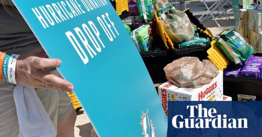
The devastation caused by Hurricane Dorian in the Bahamas has left dozens of people confirmed dead, and potentially thousands still missing. We have no food. No water. Were abandoned here, a survivor in one of the worst-hit areas of Grand Bahama told the Guardian.
Dr Hubert Minnis, the prime minister of the Bahamas, called the damage unprecedented. Another official estimated the damage could take hundreds of millions, if not billions of dollars, to repair.
A wide range of organizations are raising money to provide immediate disaster relief to survivors in the Bahamas.
Some have argued that donors who want to make a real difference after a natural disaster should try to give money to local organizations.
Donations to the government of the Bahamas
The Caribbean Disaster Emergency Management Agency has instructions for how to donate money directly to the government of the Bahamas.
CDEMA (@cdemacu)
UPDATE: The Government of the Bahamas has provided means of receiving monetary donations from the public via wire transfer. Click here for more information on how you can donate: https://t.co/mKI9xik4wg pic.twitter.com/ZeRJYXxLK2
September 5, 2019
HeadKnowles Hurricane Relief
HeadKnowles was founded by two friends in 2015 to raise money for disaster relief after Hurricane Joaquin. Since then, Lia Head-Rigby and Gina Knowles, two Bahamians living in the United States, have continued to coordinate donations for disaster relief after multiple hurricanes. The group has currently raised more than $1m on GoFundMe to help Dorian survivors. HeadKnowles has been endorsed as a trustworthy NGO by the founding director of the National Art Gallery of the Bahamas, and its leaders are cited as local relief experts in news reports.
GoFundMe also has a dedicated page of other verified crowdfunding campaigns to help those affected by Dorian.
Grand Bahama Disaster Relief Foundation
The foundation was formed by the Grand Bahama Port Authority. American citizens can make tax-deductible donations to the foundation through the Coastal Community Foundation of South Carolina, which pledges to send 100% of all donations to Grand Bahama.
The Salvation Army
The prime minister, Hubert Minnis, has reportedly encouraged donors to give to the Salvation Army, which is working closely with the Bahamian government.
The Miami Heralds Operation Helping Hands
Miami, Florida, is just a short distance from the Bahamas, and many local organizations have been coordinating aid to Dorian survivors, including the Miami Herald, the regions most prominent newspaper. The news organization pledges that 100% of funds raised will go directly to help people affected by Hurricane Dorian in the Bahamas and other affected areas.
30+ other organizations vetted by Charity Navigator
Charity Navigator, a group that vets American philanthropic groups, has a list of dozens of organizations in the Bahamas and in the United States that is says are highly rated and able to provide relief to Dorian survivors.
The charities on this list have pre-positioned resources to deliver food, emergency shelter, medical care, and other critical items to people impacted by this storm and Charity Navigator has confirmed these charities efforts on the ground, the group said.
Charity Navigator (@CharityNav)
Help families affected by #HurricaneDorian in the Bahamas and the United States today. Find the right charity here. https://t.co/PUHqxTSml3 pic.twitter.com/fnhzxlXPRR
September 7, 2019
Original Article : HERE ;
The post How you can help Hurricane Dorian disaster relief appeared first on MetNews.
How you can help Hurricane Dorian disaster relief was originally posted by MetNews
0 notes
Photo
What’s the highest point in the Netherlands? It’s Mount Scenery in the Caribbean standing at 2,910 ft. Are you confused yet?
This all makes perfect sense, because the island of Saba is a Dutch territory! In addition to Saba Island, the Dutch Caribbean also includes Bonaire, and Sint Eustatius. In case you are ever in a trivia contest, this Netherlands Caribbean tidbit is a gem!
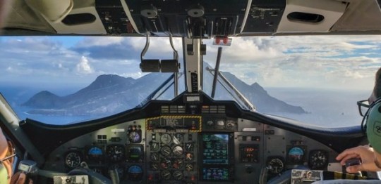
Saba is a unique, small island that has a geography and personality different from its Caribbean neighbors. It rises out of the water abruptly and looks so exotic and mystical when you fly towards it , you’ll be convinced that King Kong lives there. At only 5 square miles, it packs a big punch when it comes to hiking.

Saba straight ahead
Hiking in Saba Island Ecosystems
It seems that there is a lot of confusion regarding the exact number of ecosystems on the island. I was told there were 7, I read other accounts naming 5, and sometimes I read there were 3. Regardless of how many there are – I think everyone can agree that there are far more ecosystems than normal on a little 5 mile square island.
I’m going to go with 3 ecosystems…why?
Because I hiked in those 3 ecosystems! Plus, these three are quite distinct from one another and will offer you the largest hiking variety; coastal/tide pool, dry forest and rain forest.
There are miles and miles of trails on the island and you can bet all of them have some significant up and down. Most are signposted and cared for well. Saba’s hiking trails are the original footpaths used for hundreds of years before ‘The Road’ was created; they led to villages and down to the water for shipments. In fact one of the most difficult ones is called The Ladder because it is so steep; it was the old trail used to bring in shipments and goods before the road and harbor was built. I was told they used to carry pianos up the steep steps!
You can see all of the Saba trails here or check out the interactive hiking map here.

Where to Start Your Saba Hiking
Saba Trail Shop
The best place to start is at the Saba Trail Shop. You’ll find this helpful shop in the Windward Side near the foot of the Mt. Scenery Trail. They can help you sort out your hiking plans, give you maps, and even provide a whistle! They also suggest that you sign in/out if you are hiking alone (its good practice to do it anytime really).
The trail shop also provides information on guided hikes. The Saba Conservation Foundation’s (SCF) Trail Manager James ‘Crocodile’ Johnson leads groups on guided hikes, that can be organized in advance by visiting or calling the Trail Shop at (599)416-2630.
I actually did all of my hikes with Crocodile James – who made for an interesting trail partner! The 68 year old is an icon on the island. He can trace his Saba family back to 1661 and the Mary’s Point settlers. Once I got used to his unusual Saban accent, he regaled me in stories and history of the island! He said locals gave him the name Crocodile James because he does things ‘more crazy things than Crocodile Dundee’. He also mentioned that he nearly got attacked by a caiman once; don’t worry though, there are no caiman on Saba! However, when he told me that he had a 38 year old girlfriend, I started referring to him as Cougar James!

Saba Conservation Foundation
You may also want to start your Saba hiking research with the Saba Conservation Foundation; is a nongovernmental organization established in 1987 with a mission to preserve and manage Saba’s natural and cultural heritage. They are responsible for trail management as well as the Saba National Marine Park management. I also hiked with Kai Wulf, the Director of SCF to learn more about the hiking trails and management. He’s originally from Germany but has called the Caribbean his home for years. He’s also an avid photographer and took me to some hidden spots for photography on the island!
Hiking In Saba’s Ecosystems
One of the coolest things about the small island is you can actually do all 3 of these hikes and ecosystems in the same day if you have a lot of energy! Start at the tidal pools in the morning, then head to Sandy Cruz trail and finish with a sunset hike at Mary’s Point.
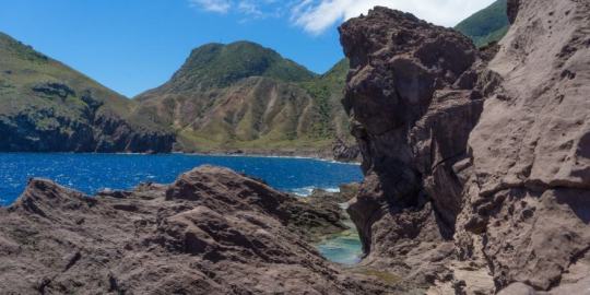
Coastal/Tide Pool Hiking
Located in Flatpoint at the airport (the runway is the only flat area on the island!), this hike is more of a scramble than a hike. This is the only part of the island where it will be brown and feel like a dry desert. I suggest you do this hike in the morning since there are no trees to provide shade from the heat. You’ll scramble over sharp, jagged pinnacles of volcanic rock, and if that wasn’t enough of a challenge, be ready to also dodge the crashing waves as you move further out onto the rocks.
This is where you’ll get to really understand the origin of Saba; the lava formations indicate a tumultuous beginning. The lava rocks are now home to a lot of sea life and beautiful, clear tidal pools. I loved hiking around the jagged lava formations searching for sea urchins in the pools! And when you turned around and looked up at the island, you could see all of the different ecosystems as if Saba was a layer cake!

Rain forest Hiking
Crocodile James took me to the Rain forest on the Sandy Cruz trail for the 2nd hike of the day. It’s located in the middle of the island from a vertical standpoint. It didn’t take us long to get swallowed up in the dense rainforest, surrounded by green everywhere! This was a mossy up and down hike that is considered more difficult. The trail connects Upper Hells Gate to Troy Hill and will take 2 to 3 hours to complete. It’s full of stunning lookouts and views as you occasionally pop out of the rain forest foliage along the trail.
We had limited time so we walked about halfway to the airport lookout and then turned around and came back. I had a clear sunny day to hike, but if it was rainy, I imagine the trail would be hard to navigate and quite slippery with all of the mossy rocks. James entertained me by pointing out giant (and useful) flora and fauna, and telling stories of pirates!
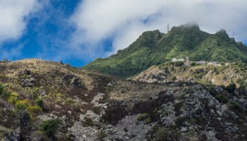
Dry Forest Hiking
For sunset, I headed to a newly refurbished trail, Mary’s Point, with Crocodile James and Kai from the SCF. Mary’s point was up, up, up through the dry forest, a completely different feel than the rain forest! Originally called Palmetto Point – it was the first settlement formed on Saba in the early 17th Century. It got the name Mary’s Point because Mary lived right on the point with her family and she was the first person you met in the village when visitors came. Plus, she seemed to also have the best cistern in that whole village, which also meant she had the all the power in the village. In the 17th century, a water source equaled power.
In 1934, due to heavy erosion in the area, residents of Mary’s Point were relocated to the Promised Land (The Windward Side). The houses were taken down completely, apart from the basements and rebuilt at their new location. But the foundations and the cisterns were left behind. James and Kai took me around the ruins of the abandoned village pointing out shards of pottery and telling stories of pirates, scientists, and drug smugglers! The two could have been a comedy act I was laughing so much.

A few ruins remain
Mary’s Point trail was just overhauled last year; they added steps and ropes to the steepest areas. I was quite impressed with the trail management by the SCF. Thanks to my fear of heights, I would’ve never been able to do the trail without these things! In fact, Saba hotels collect a $1 nature fee per night for the trail upkeep.
Be sure to hike up the ruins and then start back down before sunset to stop at the viewing point above Wells Bay to watch (and photograph) the sun go down!
Mt. Scenery Stairway and Hike
Even though I didn’t have time to do the famous hike up Mt. Scenery, try to fit it in if you can as it takes you up through another sub ecosystem – the Cloud Forest! Be ready for steps, there are 1,064 of them! The trail starts behind the Trail Shop on the Windward side and will climb to the highest spot in the Netherlands!
If there are no clouds hanging around the top, you’ll be treated to beautiful views of St Maarten, St. Eustatius, St Kitts and Montserrat. However – don’t get too excited about the view – 80% if the time the mountain is engulfed in clouds!
After a full day of hiking through all of the ecosystems, you’ll earn yourself a dip in the pool and drink at Juliana’s Hotel! And you’ll be able to say that you hiked to the highest point in the Netherlands!
Hiking Tips for Saba Island
Leave no Trace – leave the trails cleaner than what you found it
Hiking poles are a good option since there is nothing flat on Saba! They can also be rented at the Trail Shop
The trails are often slippery (especially in the rain forest) and mossy. I used Oboz Sawtooth shoe – a low hiking shoe with an exceptional grip and support for rain forest hiking
Bring lots of water – it can get really HOT – it is the tropics after all!
All trails are on private land, and we are allowed to use the trails because of the landowners’ generosity. Please respect the rights of the landowners and do not wander off the trails.
Follow my Travels
Don’t go to Saba Island in the Caribbean
June 18, 2019
5 Unique Experiences on the Faroe Islands

December 6, 2018
48 Hours in Aruba
October 17, 2013
The post Hiking Through the Ecosystems of Saba appeared first on Ottsworld Unique Travel Experiences.
0 notes
Text
Celebrating 17 Years of NASA’s ‘Little Earth Satellite That Could’
youtube
The satellite was little— the size of a small refrigerator; it was only supposed to last one year and constructed and operated on a shoestring budget — yet it persisted.
After 17 years of operation, more than 1,500 research papers generated and 180,000 images captured, one of NASA’s pathfinder Earth satellites for testing new satellite technologies and concepts comes to an end on March 30, 2017. The Earth Observing-1 (EO-1) satellite will be powered off on that date but will not enter Earth’s atmosphere until 2056.
“The Earth Observing-1 satellite is like The Little Engine That Could,” said Betsy Middleton, project scientist for the satellite at NASA’s Goddard Space Flight Center in Greenbelt, Maryland.
To celebrate the mission, we’re highlighting some of EO-1’s notable contributions to scientific research, spaceflight advancements and society.
Scientists Learn More About Earth in Fine Detail

This animation shifts between an image showing flooding that occurred at the Arkansas and Mississippi rivers on January 12, 2016, captured by ALI and the rivers at normal levels on February 14, 2015 taken by the Operational Land Imager on Landsat 8. Credit: NASA’s Earth Observatory
EO-1 carried the Advanced Land Imager that improved observations of forest cover, crops, coastal waters and small particles in the air known as aerosols. These improvements allowed researchers to identify smaller features on a local scale such as floods and landslides, which were especially useful for disaster support.

On the night of Sept. 6, 2014, EO-1’s Hyperion observed the ongoing eruption at Holuhraun, Iceland as shown in the above image. Partially covered by clouds, this scene shows the extent of the lava flows that had been erupting.
EO-1’s other key instrument Hyperion provided an even greater level of detail in measuring the chemical constituents of Earth’s surface— akin to going from a black and white television of the 1940s to the high-definition color televisions of today. Hyperion’s level of sophistication doesn’t just show that plants are present, but can actually differentiate between corn, sorghum and many other species and ecosystems. Scientists and forest managers used these data, for instance, to explore remote terrain or to take stock of smoke and other chemical constituents during volcanic eruptions, and how they change through time.
Crowdsourced Satellite Images of Disasters

EO-1 was one of the first satellites to capture the scene after the World Trade Center attacks (pictured above) and the flooding in New Orleans after Hurricane Katrina. EO-1 also observed the toxic sludge in western Hungary in October 2010 and a large methane leak in southern California in October 2015. All of these scenes, which EO-1 provided quick, high-quality satellite imagery of the event, were covered in major news outlets. All of these scenes were also captured because of user requests. EO-1 had the capability of being user-driven, meaning the public could submit a request to the team for where they wanted the satellite to gather data along its fixed orbits.
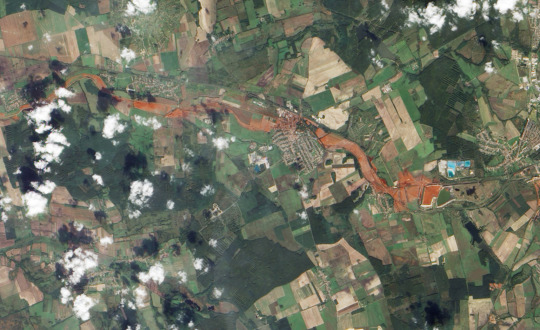
This image shows toxic sludge (red-orange streak) running west from an aluminum oxide plant in western Hungary after a wall broke allowing the sludge to spill from the factory on October 4, 2010. This image was taken by EO-1’s Advanced Land Imager on October 9, 2010. Credit: NASA’s Earth Observatory
Artificial Intelligence Enables More Efficient Satellite Collaboration

This image of volcanic activity on Antarctica’s Mount Erebus on May 7, 2004 was taken by EO-1’s Advanced Land Imager after sensing thermal emissions from the volcano. The satellite gave itself new orders to take another image several hours later. Credit: Earth Observatory
EO-1 was among the first satellites to be programmed with a form of artificial intelligence software, allowing the satellite to make decisions based on the data it collects. For instance, if a scientist commanded EO-1 to take a picture of an erupting volcano, the software could decide to automatically take a follow-up image the next time it passed overhead. The Autonomous Sciencecraft Experiment software was developed by NASA’s Jet Propulsion Laboratory in Pasadena, California, and was uploaded to EO-1 three years after it launched.
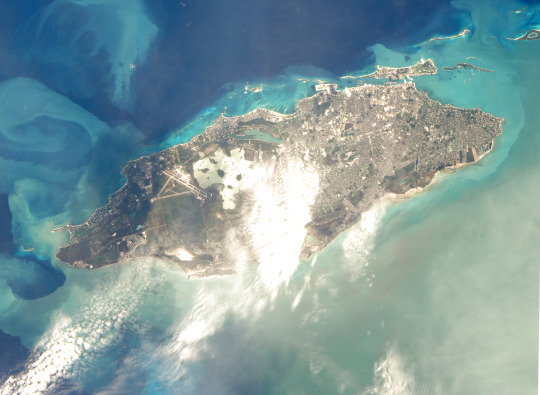
This image of Nassau Bahamas was taken by EO-1’s Advanced Land Imager on Oct 8, 2016, shortly after Hurricane Matthew hit. European, Japanese, Canadian, and Italian Space Agency members of the international coalition Committee on Earth Observation Satellites used their respective satellites to take images over the Caribbean islands and the U.S. Southeast coastline during Hurricane Matthew. Images were used to make flood maps in response to requests from disaster management agencies in Haiti, Dominican Republic, St. Martin, Bahamas, and the U.S. Federal Emergency Management Agency.
The artificial intelligence software also allows a group of satellites and ground sensors to communicate and coordinate with one another with no manual prompting. Called a "sensor web", if a satellite viewed an interesting scene, it could alert other satellites on the network to collect data during their passes over the same area. Together, they more quickly observe and downlink data from the scene than waiting for human orders. NASA's SensorWeb software reduces the wait time for data from weeks to days or hours, which is especially helpful for emergency responders.
Laying the Foundation for ‘Formation Flying’

This animation shows the Rodeo-Chediski fire on July 7, 2002, that were taken one minute apart by Landsat 7 (burned areas in red) and EO-1 (burned areas in purple). This precision formation flying allowed EO-1 to directly compare the data and performance from its land imager and the Landsat 7 ETM+. EO-1’s most important technology goal was to test ALI for future Landsat satellites, which was accomplished on Landsat 8. Credit: NASA’s Goddard Space Flight Center
EO-1 was a pioneer in precision “formation flying” that kept it orbiting Earth exactly one minute behind the Landsat 7 satellite, already in orbit. Before EO-1, no satellite had flown that close to another satellite in the same orbit. EO-1 used formation flying to do a side-by-side comparison of its onboard ALI with Landsat 7’s operational imager to compare the products from the two imagers. Today, many satellites that measure different characteristics of Earth, including the five satellites in NASA's A Train, are positioned within seconds to minutes of one another to make observations on the surface near-simultaneously.
For more information on EO-1’s major accomplishments, visit: https://www.nasa.gov/feature/goddard/2017/celebrating-17-years-of-nasa-s-little-earth-satellite-that-could
Make sure to follow us on Tumblr for your regular dose of space: http://nasa.tumblr.com/.
1K notes
·
View notes
Text
Baseball can’t rebuild Puerto Rico, but its return is a comfort after Hurricane Maria

Puerto Rico has been focused on its recovery since the devastation of Hurricane Maria. This week, MLB comes to San Juan for what will be a welcome distraction.
Bob Saget is joking about milking an Omaha cow.
Outside, New York City is frigid and windy but the air inside midtown’s Hunt & Fish Club in mid-November is far warmer, thick with money and the smell of catered sirloin. And in some sort of record for the most unexpected non sequitur from a celebrity guest, Saget is riffing about cows on stage.
He’s not doing stand-up. Saget is standing on a makeshift platform inside the high-end steakhouse alongside millionaire restaurateur and Hunt & Fish Club co-founder Eytan Sugarman, former Yankees star Jorge Posada and his wife Laura, and other wealthy friends who helped make this event — a fundraiser co-hosted by the Posadas in support of The Foundation for Puerto Rico’s Hurricane Maria Relief Fund — happen on short notice.
Mets pitcher Noah Syndergaard steadily cycles through the crowd. A top investor grabs another glass of wine before chatting with Yankees legend Bernie Williams, who applauded the Posadas for being a leader among a group of current and former players who all want to help Puerto Rico in the aftermath of Hurricanes Irma and Maria. Carlos Beltran, the newly minted World Series champion and advocate for Puerto Rico’s recovery, stands off to the side taking everything in and dispelling rumors that he has aims to be the next Yankees’ manager.
“We have been working tirelessly to show the world that we are open for tourism and business and the MLB celebration will play a significant role in doing so.” - Puerto Rico governor Ricardo Rosselló
It is less than two months since Maria hit Puerto Rico, destroying nearly everything in its path and leaving the island’s more than three million residents without electricity, water, or channels of communication. For Posada, the effort was personal. His parents are some of the many U.S. citizens who refused to evacuate despite multiple months without power and extensive hardships on the ground, which in some of the worst-hit areas included dangerous caiman-filled flood waters up to 16 feet high.
MLB is coming to the island at a good time. On Tuesday, the Indians and Twins will meet in San Juan for the start of a short series that was announced long before the hurricanes occurred.
For some of the players fundraising in Manhattan, Puerto Rico isn’t just their home, but the reason they were able to play professional baseball in the first place. Posada was an all-star shortstop at Alejandrino High School in San Juan, and he has spoken about how even if his father wasn’t a pro scout, baseball would have been impossible to escape as a kid. As a continuation of his own baseball legacy, Beltran opened The Carlos Beltran Academy in Puerto Rico in 2011, aimed at using kids’ love of baseball to maximize their educational and scholarship opportunities. Williams was signed as an undrafted free agent out of Puerto Rico on his 17th birthday.
Baseball and Puerto Rico are inextricably linked. The support of MLB players and teams after Hurricane Maria is emblematic of how strong that relationship is. By the time a Hamilton star is singing to a room full of donors and players in this gilded room, the Posadas have already made multiple aid trips, starting out helping the most at risk people — families, children, the elderly, and those who needed immediate medical attention — before moving on to “Phase 2” of “cleanup, rebuilding, and infusing the economy.”
It will be a long time before Puerto Rico is back to normal. In the meantime, baseball is always welcome.

Photo by Al Bello/Getty Images
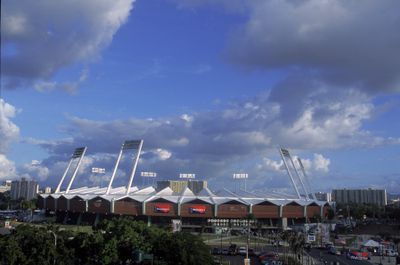
Before the game between Puerto Rico and Spain during the first round of the World Baseball Classic at Hiram Bithorn Stadium on March 8, 2013.
A namesake stadium
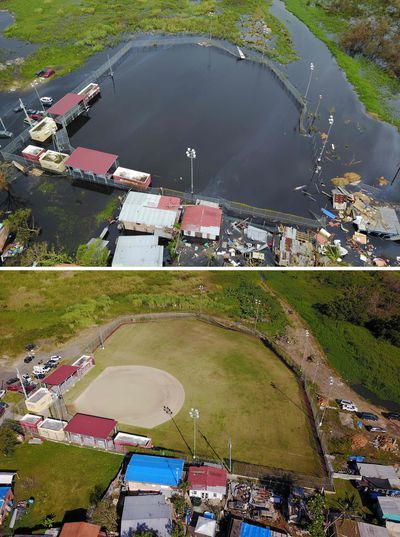
Hiram Bithorn Stadium is Puerto Rico’s most famous baseball field, named after the first Puerto Rican player to play in Major League Baseball, and as good a symbol as any of the island’s storied baseball tradition. Maria all but destroyed it.
The batting cages, the outfield fences, the statue of Bithorn that welcomed fans to games, all gone or mangled. Not many structures can stand up to the nearly 150 MPH winds that stemmed from a storm bigger than the island itself. Hiram Bithorn was no exception.
The last MLB series to be played in San Juan was back in 2010 between the Mets and the Marlins. While Hiram Bithorn may not be restored to its former glory quite yet, the stands should be packed for the return of some of Puerto Rico’s favorite sons, like Francisco Lindor and Eddie Rosario.
Puerto Rico worked hard to make sure this series would happen as planned. Carla Campos, acting director of the Puerto Rico Tourism Company, told me her hope is that the island can leverage one of the most challenging situations in a generation to make Puerto Rico even better than it was before. In 2016, tourism directly or indirectly supported 6.9 percent of all employment on the island, and contributed to 8 percent of the territory’s total GDP. According to the World Travel and Tourism Council’s analysis, those figures were projected to rise in 2017 before being interrupted by Maria.
Right now, the company’s efforts are focused on high-trafficked tourist areas, like around Hiram Bithorn in San Juan. That includes renovating hotels that were damaged in the storm and building new ones, getting cruise ships (one of the largest pieces of the tourism sector) back into port as soon as possible, and stabilizing air access.
Campos says the perception of the island’s condition has been difficult for the rebounding tourism industry to overcome, that travelers misunderstand how ready Puerto Rico is to welcome them back. And travelers are important for far more than the money they are spending on a surface level. The rebounding tourism industry allows people to get back to work and back to a routine — as Campos puts it, to “get to that sense of normalcy again.”
The series, with all of its coverage and ceremonial MLB trappings, can show how far the island has come in such a short time and encourage the necessary influx of vacationers.
Governor Ricardo Rosselló told SB Nation about Major League Baseball coming to the island: “We have been working tirelessly to show the world that we are open for tourism and business and the MLB celebration will play a significant role in doing so.”
Just as importantly, the coverage around the games has the chance to serve as a reminder of how far the island still has to go.
AFP/Getty Images
Aerial view of the flooded neighborhood of Juana Matos in the aftermath of Hurricane Maria in Catano, Puerto Rico.
Traditions to hold on to
Puerto Rico’s first baseball game was played in 1989 in San Juan, and the island’s professional league (approximately equivalent to the AA circuit) the Liga de Béisbol Profesional Roberto Clemente (LBPRC) has existed in some form since 1938. In all of the years of its existence, it has only missed one year of action — a restructuring in 2007. It was renamed in honor of Roberto Clemente in 2012.
After Maria, the league was almost forced to take the year off, but organizers decided the league had become a tradition that was too important not to play. Four teams were able to take part — the Mayaguez Indians, the Cangrejeros de Santurce, Criollos de Caguas, and Carolina Giants — in a limited series of games in January all played during the day, free for fans. The Criollos won their 18th title, tying the Indians for the most all-time, and went on to defend their Caribbean Series title.
Caguas and Mayaguez were lucky when it came to their baseball stadiums: neither was damaged beyond use and all four teams rotated using those fields for the season. They moved forward during a difficult period of time for the same reason the Twins-Indians game needed to (as the league decided in January): to try and insert some normalcy into life after the hurricane.
“People have been used to these traditions year after year for 50 years … they all expect the season.” - Dr. Ismael Pagan-Trinidad, University of Puerto Rico at Mayaguez
Dr. Ismael Pagan-Trinidad works in the civil engineering department at the University of Puerto Rico at Mayaguez with a focus on coastal resilient infrastructure. He explained how important the series would be for the community. In December, a month out from the league’s truncated season, people in Mayaguez were still using car batteries and converters to power their homes, or taking batteries from their computers and jerry-rigging them so that they could use their televisions, refrigerators, and lights.
In addition to his work at the University, Pagan-Trinidad is a member of the NCAA D-II Management Council and the co-owner of a team in Puerto Rico’s women’s volleyball league. He explained that after the hurricanes, sports largely came to a standstill in Puerto Rico. The women’s volleyball league canceled their season due to Maria, and the men canceled their planned tournament after only a few games played. Athletes on professional service contracts aren’t able to receive necessary benefits, and training on their own was almost impossible due to the lack of facilities.
Even if sports could be played normally, it’s hard to tell how many of the usual players would be around to participate. A significant portion of Puerto Rico’s population shifted to the mainland United States, and those who stayed often understandably had more pressing priorities than sports.
With baseball still being played, even on a limited basis, it gave the community something else to focus on. Before it was confirmed that baseball would return, Pagan-Trinidad said in Mayaguez, “people have been used to these traditions year after year for 50 years … they all expect the season … and people are waiting for that.”
He said fans were shocked at even the possibility that baseball wouldn’t be played this year.

WireImage
Carlos Beltran hitting an RBI single for Puerto Rico against Cuba during the 2006 World Baseball Classic at Hiram Bithorn Stadium.
“Sometimes it takes a toll on you”
If you took a bird’s eye view of Puerto Rico and drew a line down the middle, north to south, you would only miss passing directly through the small city of Coamo by a hair. Home of AAU Baseball district director Normand Valliere, it is still dealing with setbacks more than seven months after Maria.
Coamo’s baseball fields weren’t as lucky as those in Mayaguez or Caguas, and it didn’t have the same repair priority as Hiram Bithorn. Valliere’s AAU program, the 61st district in the AAU baseball system (similar to the ever-present AAU basketball circuit on the mainland), is only a little more than a year old. Before Maria hit it was growing and expanding as well as anyone could have hoped, hosting a tournament last May. Now, Coamo’s fields are destroyed as Valliere is trying to get the available kids back on a field any way possible.
Southern cities and towns were hit hardest by Maria, and their geographic location made them more difficult to reach during rescue efforts and supply distribution. Valliere is an Air Force veteran and described looking at the area in the aftermath as like looking at the photos of Hiroshima and Nagasaki after the bombs dropped. Brown land as far as the eye could see, with no trees left standing and “everything they cherished” gone in less than a day.
After the storm, with local and federal government support all but invisible, Coamo’s residents started stringing up power lines themselves. Valliere is critical of the ways in which he feels both the U.S. and local governments failed Puerto Rico through slow responses or inaction. After coming back from a few weeks with family in Tampa he found that it hurt especially hard to return to what felt like a lack of progress in his community.
Valliere noticed an immediate change in people’s behaviors and attitudes after Maria, that people were worried about whether something of this scale could happen to them again, and whether they were ever going to get back to normal. Local sports being “put on the back burner” only exacerbated this mood. Valliere is trying to help by doing “things that could be really enjoyable for [the] kids and our families, just to have something to share and to get their minds off of all the problems [they] encounter.” Valliere’s goal is to get the baseball fields fully rebuilt, and to have the kids in his program be able to play freely and without daylight or location restrictions.
The wider AAU organization has shown nothing but support for District 61, helping with fees and logistics in the lead up to the National and Grand National tournaments that will take place this summer in Florida. Valliere is hoping to send at least two teams in hopes of giving the teenagers in his program something to prepare for and accomplish rather than linger on Coamo’s continuing struggles.
According to Secretary of Sports and Recreation Adriana Sanchez, the government is working with FEMA and others to get all complexes, but baseball especially, back up to snuff so that kids can be back outside and playing. While they say they are on track with their efforts, things are still far from where they were.
During our conversations, Valliere didn’t miss a chance to remind me of all the help still needed on the island — of the magic they need to start having normal lives again, and how important it is for people in the 50 states to not forget how tough life is for hundreds of thousands of people living only a short flight away from their mainland homes.
Getty Images
Hiram Bithorn Stadium before a game between the Texas Rangers and the Toronto Blue Jays in 2001.
A little hope and happiness
No matter their current situation, Puerto Ricans are largely happy the MLB series is happening, and that Puerto Rican players are returning at this crucial time. MLB could not have known the circumstances these games would be played under when it first announced the teams and dates last June, but the series is resonating with people who desperately need a break.
Sanchez said that increased tourism could help create future opportunities for lower profile sports on the island. She specifically cited Alex Cora’s clause in his managerial contract with the Red Sox that guaranteed a relief trip, one that donated 10 tons of supplies to the island and $200,000 to Cora’s hometown of Caguas to help restore electricity. In tandem with MLB and this series, her department is offering clinics for players between 14 and 18 years old in multiple municipalities.
Other events have been held on the island since Maria hit — including an Iron Man, and an unofficial PGA Tour event — but Campos is excited for the magnitude of the Indians-Twins series, and the boost it will provide now that the island is better prepared to welcome visitors.
For all of the fury that Valliere carries about the ways in which government has failed Puerto Rico, he was grateful for what MLB owners and players have done, and are still doing, to help those in need on the island. His only complaint was that more of them could have followed the lead of Astros owner Jim Crane, who deployed a plane full of supplies within weeks of the hurricane (“I wish everyone would have done the same thing”). But, he acknowledges, overall he thinks MLB has showed an incredible display of support.
“They have done an amazing job, OK? They’re going to continue doing it because one of the things we do have is we just love our island. We love our people and we do whatever it takes to get it back to normal. And they’re doing a heck of a job.”
The most unabashed excitement I’d heard in Valliere’s voice throughout multiple conversations was when he praised the two-game series.
“It was like they’re mad and ready to get going. To pick themselves up and dust themselves off and just keep going.” - Bernie Williams
“We need things like that, because it will take your mind off of all the problems that we have and we get a week,” Valliere said. “A week of happiness. Because we do have kids that are athletes, and we’ve got players like Francisco Lindor and Roberto Perez and Eddie Rosario ... and Eddie Vargas and I’m just mentioning a couple. They’re going to be here and it’s going to be the first time, and I’ll bet you their hearts are beating probably a thousand times harder than they used to because they want to play in front of people.
”Just to bring a little bit of hope and happiness to us, that’s all that matters right now.”
Hurricane season is mere weeks away, and it’s impossible to predict what setbacks could arise over the next few months. The phrase that came up most often in conversations with Valliere and others is that the communities will keep working. They’re working together, working as a team, working for the kids, and “working their butts off” to get back to some kind of normal.
In Mayaguez, Pagan-Trinidad is already helping his community prepare for next time, despite how tough it is to imagine that this might happen again. Students are learning practical applications of their civil engineering studies — how to create hydro power in emergency conditions, for one — and the area is planning how to live for months without clean water, or how to get through the early stages of an emergency more effectively knowing they won’t be able to communicate with other parts of the island for multiple weeks.
Puerto Ricans are resilient, one of the first things they will tell you when looking back on the last seven months. Bernie Williams said as much back in November when I asked him what struck him most when visiting his hometown for the first time after Maria.
“People still manage to find happiness,” he said. “In the midst of this tragedy they still find a way to make humor in light of the fact that they are going through one of the worst natural disasters that have hit the island in the past hundred years … It was like they’re mad and ready to get going. To pick themselves up and dust themselves off and just keep going.”
Williams is singing the national anthem to start the series and Carlos Beltran is throwing out the first pitch. They’ll be leading off two days of excitement for fans all across the island. Two days for fans to be distracted from hardships on the ground, the lack of basic necessities and all of the problems still gnawing at the back of their minds waiting to be solved.
Then after it’s over, when both team planes have been packed up and pointed back to the mainland so that the Indians and Twins can continue their seasons, Puerto Rico will get back to the many problems at hand. Because there’s still so much work to be done.
0 notes
Text
Apple, Conservation International and Colombian Communities Partner to Protect Earth’s Carbon-Trapping Coastal Trees
The roots of a mangrove tree are like veins. They rise up and plunge down into the salty waters of Cispatá Bay in Córdoba, Colombia, along the coast of the Caribbean Sea, sprawling in every direction. A series of channels have formed an arterial highway connecting to the Sinú River, providing single-lane access into and out of the mangroves where fishermen and loggers begin their day’s work.
“Right now we have a lot of people working on opening channels to keep the water flowing,” says Luis Roberto Canchila Avila, president of Asoamanglebal, the first mangrove association in San Bernardo del Viento in Córdoba. “Because we are in summer, there are parts where the water flow is different and fish die as they are left without oxygen.” It’s a delicate balance: too much river water or too little salt water, and the mangroves could be destroyed.
The mangroves have long been a lifeline for the coastal communities of Colombia. They protect them from storm surges and provide food and wood supplies to families. They are also a lifeline for the world, sucking carbon out of the atmosphere and storing it deep in their soil below water for centuries. Recent studies show they can store up to 10 times the amount of carbon per acre as land-based forests.
But pressures from illegal farming, fishing and logging combined with climate change are threatening their existence. “There are many illegal groups working in the mangroves,” Canchila Avila says. “They don’t know or care for the sustainability efforts.” According to Conservation International, when degraded or destroyed, mangroves and other coastal ecosystems emit the carbon they have stored for centuries into the atmosphere and become sources of greenhouse gases. They estimate that as much as 1 billion metric tons of CO2 are being released annually from degraded coastalecosystems.1 That’s equivalent to the total annual emissions from cars, buses, aircraft and boats in the US in 2017.
On this humid, sunny April morning, Cispatá Bay is still, save for a few local fishermen waist deep in the sea casting their hand-woven nets. Here, Conservation International and Invemar Research Institute are collecting mangrove soil samples to be analyzed for carbon stored in sediment below the waterline, known as “blue carbon.” Together with the Omacha Foundation, the three organizations are designing a carbon financing model to incentivize conservation and restoration of mangroves in the region, working in partnership with the local government environment authority (CVS) and the local communities.
For Apple’s Earth Day 2018 Give Back campaign, Apple partnered with Conservation International to protect and restore the 27,000-acre mangrove forest in Cispatá Bay, which is expected to sequester 1 million metric tons of CO2 over its lifetime. At the Global Climate Action Summit last September in California, Apple’s Vice President of Environment, Policy and Social Initiatives Lisa Jackson underscored the importance of this type of preservation. “These forests are critical because they’re one of nature’s most important tools in the battle against climate change,” she said. “Globally, we’ve lost half of the world’s mangrove forests since the 1940s — so it’s high time we start preserving and protecting them.”
Conservation International’s project is the first in the world to fully quantify blue carbon credits in both trees and soil, and will be a model for scaling carbon sequestration in global mangrove ecosystems and curbing emissions caused by deforestation in these areas.
“We are pioneering this new wetland model,” says María Claudia Díazgranados Cadelo, marine biologist and director of Marine and Community Incentive Programs at Conservation International. “We need to strengthen the way we measure carbon stocks in the soil component of the mangroves. Other methodologies only use above-ground biomass without taking much consideration of the soil, which for mangroves and other coastal ecosystems is the most important place where those ecosystems store carbon.”
Beyond the bay, there are hundreds of families living and working with the mangroves. The mangleros, as they are called, are part of a network of local mangrove associations formed to conserve and protect the mangroves as well as the communities that rely on them for food and income.
In the neighboring town of San Antero, Cispatá native Ignacia De La Rosa Pérez, manages the relationship between the community and the nonprofit organizations through the Independent Mangrove Association. “I was practically born in the mangroves,” De La Rosa Pérez says. “When I was a little girl I began to lead expeditions into the woods and explore life. I didn’t know I was a leader, but everyone followed me. That’s how I began leading movements.”
Since 1976, De La Rosa Pérez has collected decades of data on the mangroves, including details on the animals that live there, the health of the mangroves and the channels that run through them. Binders of maps and in-depth analysis on the characteristics of these coastal trees line two bookshelves in her home office. She holds the greatest collection of data on the region since long before Cispatá Bay was classified as a Marine Protected Area Subsystem, the terms of which also reside in a few binders in De La Rosa Pérez’s home.
“We saw the shift in the mouth of the river,” De La Rosa Pérez says. “We saw changes in the ecological processes from the animals to the forest. Everything continued to change, and finally one mangrove that had been there for three or four centuries shifted onto the land, so as time went by, people began to sustain themselves from the mangroves.”
As De La Rosa Pérez recalls, the community would sell whatever they could: wood, tree bark, fish and crabs. So when a local politician tried to label the mangrove workers as ecological predators, De La Rosa Pérez was enraged. While the mangrove workers were accused of destroying the trees through their fishing and logging practices, the reality is the trees were actually dying on their own.
“We’ve begun to speak a new language, a cross between the language of the professionals, of technicians and scientists, and the language of the community.”
“When I was 3, we would compete to see who could find the biggest tree that was buried,” De La Rosa Pérez says. “The mangrove had disappeared, maybe because of the salinity or lack of tributaries. That experience resulted in an answer in ’92 … I went out to the salt mines with the mangrove workers. They dug out the dirt with their hands and with shovels. They pulled up the tree to prove they hadn’t cut it down.”
That proof laid the groundwork for a long-term alliance between the local community and CVS, establishing a set of sustainable practices for using the mangroves. Among them is a rotation plan for leveraging the mangroves from only one designated area at a time so that each zone has time to recover and restore itself.
“We’ve begun to speak a new language,” De La Rosa Pérez explains, “a cross between the language of the professionals, of technicians and scientists, and the language of the community. That’s what made us grow and be able to reach the place that we all are in today.”
Twenty-five miles east of San Antero in San Bernardo del Viento, Asoamanglebal’s Canchila Avila is managing a similar relationship between the community, the local organizations and local government. While Canchila Avila coordinates the sustainable cutting and clearing of mangroves to maintain water flow, he also assigns permits for cutting wood to be sold for construction purposes. “We take from the mangroves but we’re also preserving them,” Canchila Avila says. “If we find an area with very few trees, we know that it needs rehabilitation and it needs to recuperate. We let that area restore and we add trees.”
“We know the area and we know the height of the river, so we used to cut without any prior technical knowledge just because we grew up watching how it was done,” Canchila Avila says. “Today we combine technical knowledge from CVS with our experience.”
Canchila Avila, De La Rosa Pérez, Díazgranados and a team of marine biologists and environmentalists are all on the frontlines of these conservation efforts. Without the knowledge and experience of the mangleros, preserving the mangroves would be almost impossible.
“They are our right hand in terms of conservation efforts,” Díazgranados says.
The root between the people of Cispatá Bay and the mangroves runs deep. So much so, that every year, the Festival of the Donkey during Holy Week serves as a reminder. Based on a biblical tale retold through the lens of a local puppeteer, masked donkeys carry a man to the town square where he is sentenced to death for his crimes and must read his will. In it, he declares: “To the people of the mangroves, I leave the mangroves.”
Conserving mangroves, a lifeline for the world Apple, Conservation International and Colombian Communities Partner to Protect Earth’s Carbon-Trapping Coastal Trees The roots of a mangrove tree are like veins.
0 notes
Text
A closer look at the diabetes disaster
In Belize, where diabetes is rampant, patients need insulin every day to maintain proper blood sugar levels. But if people lack electricity or a refrigerator, they cannot store insulin at home. Medical advice pamphlets encourage such patients to keep their insulin in the refrigerators at small corner grocery stores instead. And so, in some cases, there the insulin sits — right next to soft drinks which, in good measure, have helped cause the growing diabetes epidemic in the first place.
“That one image, of soda bottles and the insulin side by side, has stuck with me,” says Amy Moran-Thomas, an MIT professor and cultural anthropologist who has spent over 10 years researching and writing about the global diabetes epidemic. “It’s emblematic of the larger problem, a robust infrastructure even in rural areas to deliver foods that are contributing to diabetes, and the huge gaps in global infrastructure for treating the same conditions.”
The International Diabetes Foundation estimates that 425 million people currently have diabetes, and that number is expected to increase to more than 600 million within a generation. (By the foundation’s count, annual diabetes deaths now outnumber those from HIV/AIDS and breast cancer, combined.) U.N. Secretary General Ban Ki-moon has called chronic illnesses such as diabetes a “public health emergency in slow motion.”
Now Moran-Thomas has chronicled that emergency in a new book, “Traveling with Sugar: Chronicles of a Global Epidemic,” published this month by the University of California Press. In it, Moran-Thomas examines the havoc diabetes has caused in Belize, a Central American country with resource limitations — annual per capita income is under $5,000 — and one that is heavily reliant on cheap, high-glucose foods made with white rice, white flour, and white sugar.
“Before I started getting to know people, I had this idea that infectious diseases were the primary health crisis in a lot of Central America,” says Moran-Thomas, who as a graduate student initially considered studying the problems of parasitic infections. Instead, she discovered, “Everyone was talking about diabetes.”
Looking at the scope of the problem as well as its causes, Moran-Thomas says she came to regard the situation in Belize as a case study in how lives are rearranged by the spread of diabetes globally: “I felt this was part of something bigger that was happening in the world.”
Vanishing from the photo album
Diabetes is a disease with many possible consequences. Patients often feel excessively thirsty or hungry, although those are just early symptoms; complications and effects over time can lead to heart failure, stroke, kidney failure, blindness, and amputation of limbs, among other things. Diabetes is so strongly associated with managing blood sugar levels that the word “sugar” has become a virtual synonym for the illness in many places; in Belize “traveling with sugar” is a common expression for living with diabetes.
Moran-Thomas conducted her ethnographic research in collaboration with people in Belize, getting to know many families and community caregivers. She also conducted years of archival research about the social context, reconstructing the history of colonialism and commerce that has left Belize largely impoverished and dependent on outside sources for food and income.
Grappling with matters that resonate across the Caribbean, Latin America, and beyond, “Traveling with Sugar” closely examines how sugar-heavy diets became so common. This includes issues such as the legacy of plantation landscapes on contemporary agriculture, and the ways diabetes risks are compounded by toxic pollution, climate change, stressful social environments, and interruptions of therapy.
The human consequences are stark. Among the stories Moran-Thomas chronicles in the book, one involves an older man lovingly paging through a family photo album showing how his late wife, a teacher, had endured multiple amputations — first a foot, then both legs below the knees — which became woven into the family’s larger story of caring for each other. In the family photo album, Moran-Thomas writes, “we watched her disappear a piece at a time from the pictures, until she was absent altogether.”
As people’s bodies have changed, Moran-Thomas observes, the local landscape has too. The first place where she conducted an interview in Belize is now under water, due to coastal erosion and sea-level rise. Such cases will become more common in Belize and around the world, Moran-Thomas thinks, if the global economy promoting the growth of “carbohydrates and hydrocarbons” continues unaltered.
“There is so much profit being made from the products that contribute to the condition, and there is also money to be made for treating its harmful effects,” she notes. “So it’s difficult to think about interrupting this engine, when money’s being made on both sides, of causing and treating a problem.”
Belize’s status as a resort area also leads to some incongruous scenes in the book. Oxygen-rich hyperbaric chambers can help prevent diabetic amputations, and do exist in Belize — but primarily for tourists, such as divers with the bends. Many Belizean citizens have barely heard of such devices, let alone used them for diabetes care.
“There is a segregation of infrastructures,” Moran-Thomas says. “The hyperbaric chambers exemplify that — Caribbean residents dying from amputations without being able to access the chambers in their own countries.”
Grassroots initiatives and equitable design
The research behind “Traveling with Sugar” has already been the basis of interdisciplinary work at MIT, where Moran-Thomas has collaborated with Jose Gomez-Marquez and other members of the Little Devices Lab to create a new MIT course, 21A.311 (Social Lives of Medical Objects). One focal point of the class involves bringing together readings with lab exercises to examine what the sociologist Ruha Benjamin has called “discriminatory design” — the outcome of which is that objects and devices can be impossible for many people to use effectively.
“Discrimination doesn’t have to be intentional in order to produce a pattern of exclusion that really impacts people,” Moran-Thomas says.
For instance, she adds, “Glucose meters can’t really be repaired by the people who need them most to thrive. This makes life so much harder for people who need those meters to safely manage drugs like insulin. I think that’s an additional entry point for thinking about the delivery of health care — the assumptions built into objects has a huge impact on delivery working. At places like MIT, co-created design ideas can be put into practice. [The students] did some amazing final projects for that class, trying to reimagine what equitable objects could look like.”
Beyond medical technologies, and alongside large-scale national or international action, Moran-Thomas suggests, the ongoing work many communities are doing to reverse the diabetes epidemic from the ground up deserves more recognition and resources.
“The grassroots level is where I saw the most committed work for real change,” says Moran-Thomas, citing projects like a diabetic foot care group working to prevent amputations and a local farming cooperative building a healthy-cereal program.
“I don’t know how to reorganize a global trade system — though more policies trying to address those things are absolutely crucial,” she adds. “But there are so many tiny, vital steps that people are already working on at the level of their own neighborhoods and communities. I focused on those stories in the book to show how a future approach to diabetes response can build from that grassroots scale.”
A closer look at the diabetes disaster syndicated from https://osmowaterfilters.blogspot.com/
0 notes
Text
The Sint Maarten Nature Foundation has started the process of outplanting the first fragments of coral on reefs within the Man of War Shoal Marine Protected Area as part of its ‘Fragments of Recovery, Coral Reef Restoration Program. The project was launched with the assistance of the Coral Restoration Foundation, NOAA, the Coral Reef Restoration Consortium and the Dutch Caribbean Nature Alliance after some 80% of some species of coral and most of the previous coral nurseries were damaged or destroyed by Hurricanes Irma and Maria.
“The first Staghorn and Elkhorn corals have been transplanted unto reefs within the Marine Park from our coral nursery station close to Simpson Bay. We planted back both species of coral and will be monitoring them for a while to see how they perform,” commented Nature Foundation Projects Officer Melanie Meijer zu Schlochtern.
“Now that we are in a phase where we are further along in our recovery we have started to ramp up our coral restoration program to restore some of the damage to our coral reefs caused not only by the Hurricanes but by the issues the island has been facing over the last few decades in terms of unrestrained coastal development and improperly managed waste-water. We received tremendous help from the community after the Hurricane as well as from the Coral Restoration Foundation, the US National and Oceanographic and Atmospheric Association (NOAA), the Dutch Caribbean Nature Alliance and the Coral Reef Restoration Consortium to get our project going again. We will continue to plant coral in the Marine Park from our nursery when they are healthy enough to help restore the reefs that were severely impacted. We estimate that we lost about80% of our coral combined,” commented Tadzio Bervoets, Nature Foundation Manager.
The Nature Foundation also received support and expert assistance from Jamaican Coral Restoration Expert Michelle McNaught during the initial stages of populating the fragments.
DCIM100GOPROGOPR0414.JPG
Nature Foundation Plants First Coral Fragments from Coral Nursery in Marine Park as Part of ‘Fragments of Recovery” Post Hurricane Coral Reef Restoration Program The Sint Maarten Nature Foundation has started the process of outplanting the first fragments of coral on reefs within the Man of War Shoal Marine Protected Area as part of its ‘Fragments of Recovery, Coral Reef Restoration Program.
0 notes
Text
A TOTAL commitment to Jamaica
New Post has been published on https://goodnewsjamaica.com/business/a-total-commitment-to-jamaica/
A TOTAL commitment to Jamaica
The TOTAL service station on Waltham Park Road in Kingston. (Photo: Garfield Robinson)
Frenchman David Ducognon is clear about one thing — TOTAL Jamaica, the petroleum giant, is a Jamaican company that simply enjoys the international best practices of its French parent.
“We are totally committed to Jamaica,” Ducognon insisted in a recent interview with the Jamaica Observer. “In the next few months, the public will see how we are improving our service delivery. We employ 50 people at our head office, and across our service station network we have close to 1,000 employees.”
Since investing in Jamaica in 2004, TOTAL has rolled out improved convenience stores and plans to offer free Internet access to entice its customers to do more than just fill up with gas and go. Further, in the coming months TOTAL will unveil its version of a quick repair auto shop, appealing to its customers who want the convenience of speedy motor vehicle repairs.
While declining to give the dollar value of the investments in Jamaica or the profits that TOTAL enjoys from its Jamaican operations, Ducognon said, “Like any company who makes an investment, it is because it expects to make a satisfactory return. And while we cannot divulge our financials, we can say that we are committed to growing our customer base in Jamaica.”
Elsewhere in the Caribbean, TOTAL is found in the French-speaking territories of Martinque, Guadeloupe, and French Guiana. Although the company decided against offering gas stations in Haiti recently, Ducognon did confirm that it has a presence in that country through its lubricants arm.
TOTAL also has a presence in the Dominican Republic and Puerto Rico.
Ducognon has been managing director of TOTAL Jamaica since August 2016. Hailing from France, he was previously deputy director of eastern, northern and central Europe, as well as Russia.
Compared to his continental experience, Ducognon explained that “Jamaica is a very interesting market. It is growing and we have a positive outlook about the economy. From what we see, what is being developed with the growth initiative across the various sectors gives us a positive outlook. We are all living in interesting times in Jamaica and we want to be part of the growth story.”
Currently the company is promoting its new fuel formulation that it also markets in Europe. Ducognon noted that across the company’s 57 service stations in the island, TOTAL is striving to meet the demands of consumers that know they have choices in terms of where they buy petrol.
“What is special about the TOTAL gas stations? We are not just selling fuel, we are selling convenience. We have the best network and the widest with 57 service stations, so easy location is very important to the consumer and we are eager to provide high-quality products to our consumers,” he told the Business Observer.
“In the service station model, we have our own stations and we franchise as well. Our view is that competition makes you better and forces you to innovate to be the leader. We are investing a lot in our convenient stores, plus we opened two new restaurants [and] we will open car service stations to start at Deanery Road and Waltham Park Road,” he said.
“These locations for our auto care services will offer lubricants, oil service change, small mechanical service (tyres, alignment, basic mechanical service). What is important is the rapid service and this should be up and running by August, and we plan to give free Wi-Fi at all convenience stores across the island. So 2018 will be the year that a lot of the work we prepared for will be showcased,” he explained.
Another touch point for Ducognon is credit card safety. “In May we won the golden award from the National Commercial Bank for safety. This involved training of service station staff. We were recognised as the service station with the safest credit card transactions. Essentially, we have made it so inconvenient for thieves to swipe card information that they don’t bother with TOTAL gas stations,” he said.
Corporate social responsibility is also an important element of TOTAL’s involvement in Jamaica. “As a group, we have a TOTAL Foundation which has four areas of concentration in the 130 countries in which we operate. The foundation focuses on the environment, education, road safety, and cultural/heritage upliftment of the country we are operating in.”
Ducognon explained that in Jamaica the foundation has been working with three pillars — the environment, education, and road safety.
“In terms of the environment, we have long-term partnership with Jamaica Environmental Trust where we help them create school environmental plans, tree planting, and inter-coastal clean-up each year,” he said.
“As it relates to education, in 2015 we signed a memorandum of understanding with The University of the West Indies (UWI) where we send political science students to France, and we also have a student internship in the TOTAL system and we are still looking to expand the UWI relationship.
“Next is road safety, which is very important. Jamaica has high road fatalities and we are concerned about that, and so we target children through a programme called Children Against Reckless Driving to educate them before they are driving and [encourage them] to respect the regulations. It’s about adjusting behaviour before bad attitudes to road safety set in,” he explained.
Giving an assessment of the company’s future here, Ducognon said: “The outlook for Jamaica and TOTAL is very bright. We will continue to innovate in the retail, aviation, lubricants and service station sector of the petroleum industry of the country.”
By: Dennise Williams
Original Article Found Here
0 notes
Text
Gunas, The Ethnic Group Cornered By Climate Change - ENVIRONMENT
New Post has been published on https://citizentruth.org/gunas-the-ethnic-group-cornered-by-climate-change/
Gunas, The Ethnic Group Cornered By Climate Change
(Centro de Periodismo Investigativo, by Mary Triny Zea) The natives of Cartí Sugdup island, in the archipelago of Guna Yala — known worldwide as San Blas — on the northeast end of the province of Panama, are ready, between fears and hope, to move to the mainland and become the first Latin American indigenous settlement displaced by climate change, according to non-governmental organization Displacement Solutions. In 2017, the Panamanian state resumed its relocation project, which began in 2010.
Some 1,450 gunas will leave their traditional huts with white sugarcane walls and straw roofs, located on one of the largest islands of the archipelago, to inaugurate, in 2019, some 300, 41-square-meter, two-bedroom homes, with areas for the tribe’s cultural meetings, whose total cost reaches $10 million, according to the government project.
This would unleash the exodus of one of the 36 inhabited islands, of a total of 365 of this indigenous region whose population totals 33,109 inhabitants, distributed among coastal lands and islets.
This move means for many of the “kunas,” as they were called until 2011, the return to their roots. Historically, they come from the mainland, from the Colombian regions of Urabá, Antioquia and Caldas. Now they are called gunas because in their alphabet the letter “K” does not exist, a request that emerged from the general congresses of the Bilingual Cultural Education Program.
The accelerated rise in the sea levels — which has already erased some of the islands surrounded by white sand and clear waters that make up this archipelago paradise — coupled with the overcrowding in which they live — because of their beliefs to bring into the world as many children as “God would send them” — forced them to make this decision that still generates debate in 40 other island communities.
A witness to that is a neighbor to the island and mathematics professor, Diomedes Fábrega, who recalls there used to be an island called “Noromulo” that disappeared 10 years ago. He says the increase in temperatures makes his teaching difficult, and that floods in Cartí Sugdup — given the rise in sea levels — used to take place between December and February, but as of five years ago they have been recorded since August.
The “guna” culture, their spirituality and traditions, are at stake with the move, warns Dalys Morris, a “guna” teacher who belongs to the relocation committee, so they are self-managing the preparations. She says that they have not been guided by the State but that the support has come from international organizations, an opinion shared by islander Vicente González, who maintained that they have no contact with the Panamanian authorities to address the issue of climate change, not even from the Ministry of the Environment, despite the existence of the Climate Change Unit, created in 2006.
The relocation of the gunas is not just about a physical or geospatial issue. It also implies a cultural change. “We plan to offer different seminars on life on the mainland, where we will address, for example, the handling of garbage to avoid diseases,” said Morris. Although they are not completely convinced about the proposal to live in these small houses and they worry about how they will pay for them, they are aware that they have no other alternative, she said.
The Caribbean Sea, where Guna Yala is located, rises between three and six millimeters a year, which supposes an increase of up to 60 centimeters in 100 years, and in the worst-case scenario, between two and five meters, explained scientist Steven Paton, who is the director of the physical monitoring program of the Smithsonian Tropical Research Institute in Panama. This forces the natives to leave the islands, because they are already flooding.
During last December’s first few days, the strong winds coincided with the high tide and during two days, the sea covered all of the Guna Yala islands. Water rushed into their homes, indigenous activist Blas López said. “The people were very afraid; they had not seen this before. They feel that the sea is increasingly rising” and the barriers that they build with corals and trunks were not enough because the water reached their ankles, explained López.
Despite explanations and scientific projections, the gunas are divided between the grandparents who refuse to leave the sea and the young people — the majority — who feel the imminent threat.
Arcadio Castillo, a guna biologist and fish ichthyologist, describes the differences in Guna Yala’s marine life: “in my childhood, there were plentiful fish and lobsters; now you have to paddle a kilometer outside [the islands] and there are fewer fish. “This happens because of the overfishing of parrotfish, which eat the algae and control their growth so they don’t harm the corals.
Castillo, who is of medium height — like the rest of the gunas — confirms that flooding in the islands is nothing new, although between 1970 and 1980, during the trade winds or rainy season, the water that flooded his house did not reach his ankles. Today, the event is more severe and goes above that part of his body. He believes this situation has worsened because the gunas are eliminating the reefs.
Looking to expand their islands, the gunas remove the “elk horn” and “finger” corals located near the coast or in shallow waters that may have up to one-and-a-half meters of ramifications, and coupled with the seagrass, they make fences, where they throw garbage and dead corals, which are added to gravel and sand. They try to gain land from the sea. But some of these rudimentary fillings are destroyed by the waves, Castillo said.
The bleaching and death of corals, which serve as a natural protection barrier, is 98% due to high water temperatures, according to studies carried out between 1983 and 2003 in various parts of the world. “Since then, the water has been hotter,” said Thomas Goreau, president of the Global Coral Reef Alliance.
But, for gunas like 77-year old José Davis, spokesman for traditional authority, the concept of climate change means nothing: “it does not have as much strength for the Kuna.” However, he welcomes the idea of the relocation, claiming it means returning to their “origins as a mountain people that 120 years ago populated the archipelago.”
For Davis, to occupy the 22 hectares in the future community in Llanos de Cartí, a wooded area that was cleared for resettlement, means “increasing agricultural production and having more space to improve the quality of life. We want to move because of the overcrowding.”
Llanos de Cartí, the continental area where they will relocate to and that is part of the region’s collective lands, is a silent witness to the millions of misspent dollars using this ethnic group as an excuse. There is a school and a half-finished health center there, supposedly for the new life of the gunas on the mainland.
The construction of the health center abandoned by Omega Engineering in 2014 is being investigated for possible acts of corruption during the presidency of Ricardo Martinelli (2009-2014,) while the school with dormitories faces administrative problems, despite being 90% complete.
For López, the relocation implies more than the delivery of the houses. “It’s not just building the houses, you need the teaching factor on climate change.” “There is a lack of awareness about the rising sea level,” in addition to coordinating with the authorities a national plan, in case of natural disasters, he said.
A dozen gunas and environmental organizations coincide on this point. Edmundo López, president of the Research and Development Institute of Guna Yala, affirms that it has been 10 years since the Ministry of Environment (MA) “has manifested itself in his community despite having an office in the region and related legislation.
Five months ago, La Prensa asked for an interview and sent requests for information to the Climate Change Unit of the MA to address the issue, but there was no response.
Although Panama is a country with extensive coastlines — 1,287 kilometers in the Caribbean and 1,700 kilometers in the Pacific — their annual loss due to the rise in sea levels is unknown, scientists agree. The MA assesses coastal vulnerability and analyzes eight vulnerable zones of the country, although it did not know this indicator.
The Environmental Advocacy Center, an environmental law organization, believes the Climate Change Unit is only a entity “on paper” to comply with international requirements, as it lacks concrete actions and indicators in this regard, said its biologist, Isaías Ramos. For his part, Ricardo Wong, director of the Promar Foundation, said leadership is required from the ministry and more education for the population to adapt to this new climate reality.
Although the Guna Yala archipelago is the most susceptible area due to climate change in Panama, it is not the only place. The Caribbean provinces of Bocas del Toro and Colón have also been affected. The first had its Laguna de Chiriquí bay forests destroyed five years ago by seawater floods, and in the second — for the past seven years — hundreds of homes have flooded, there are collapsed infrastructures, and the mangrove was destroyed due to the port and commercial expansion of the Colón Free Zone (ZLC, for its initials in Spanish.)
The district of Colón in that province runs the risk of sinking below sea level, given that at present it only has 10% of its mangroves. Smithsonian researcher Stanley Heckadon, warns that in 100 years, several residential complexes will disappear. He recalled that between 1920 and 1980 the sea rose 10 centimeters in the village of Cristóbal, where one of the most important ports in the country and the ZLC are located.
youtube
This story is part of the ISLANDS ADRIFT series, resulting of the work of a dozen Caribbean journalists led by the Center for Investigative Journalism (CPI) in Puerto Rico. The investigations were possible in part with the support of Ford Foundation, Para la Naturaleza, Miranda Foundation, Angel Ramos Foundation and Open Society Foundations.
PARA HACER QUE INVESTIGACIONES COMO ESTA SIGAN SIENDO POSIBLES
DONA AHORA
India Cuts Royalties to Monsanto, is There a Link Between Monsanto & Indian Farmer Suicide?
0 notes
Video
Three (3) members of the Caribbean Coastal Area Management Foundation (C-CAM, @ccam_foundation ) recently received certificates as Competent Crew from the Caribbean Maritime Institute (now University) while one of the members is now fully licensed as a Coxswain Driver to operate seafaring craft in the Portland Bight area. The training and certification were facilitated under the Community Tourism component of the Jamaica Social Investment Fund’s Rural Economic Development Initiative (REDI funded by the World Bank and the Government of Jamaica. Fisher folk and community residents associated with CCAM have now upgraded their competency to host local and foreign tourists having also had Team Jamaica and Tour Guide training and certification. All of this allows C-CAM to receive Jamaica Tourist Board licensing and to offer tours for sale on the Jamaica Community Experiences website www.MoreToJamaica.com . . #JSIFJA #InvestingForCommunityDevelopment #TeamJSIF @jsifja
0 notes
Last Seen Blogs

lesraffineursdedonnees
Les raffineurs de données

cestlaviepeople
Clown

maxannedaily
I will stand in between you and them, and I will protect you.

kiaranator
runescape goblin