#Landsat
Text
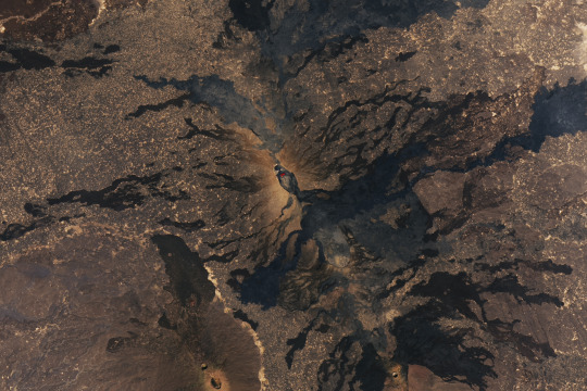
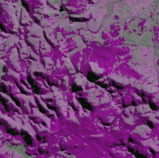
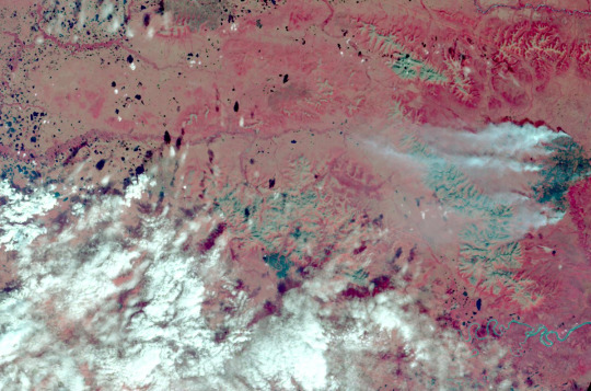
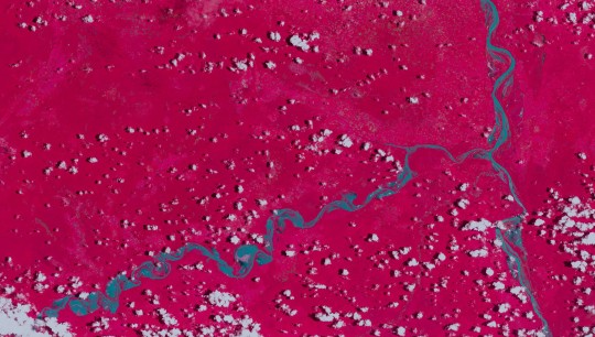
Erta Ale volcano in Ethiopia
The image was acquired by the OLI (Operational Land Imager) on Landsat 8 on November 27, 2023
15 notes
·
View notes
Video
youtube
Landsat's Next Chapter With a trio of smaller satellites that can each detect 26 wavelengths of light, the Landsat Next mission is expected to look very different from its predecessors that have been observing Earth for 50 years. This new plan for Landsat Next, a joint mission of NASA and the U.S. Geological Survey, is designed to provide more frequent, and finer resolution, data of the changing surface of Earth.
2 notes
·
View notes
Photo
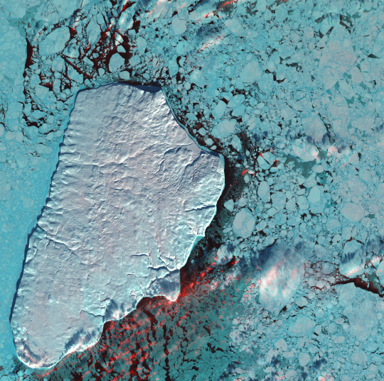
This satellite image shows a snow-covered Akpatok Island in Ungava Bay, a large bay located in northern Quebec, east of Hudson Bay.
Description from the original Flickr photo page:
January 1st, 2001: Description: Akpatok Island lies in Ungava Bay in northern Quebec, Canada. Accessible only by air, Akpatok Island rises out of the water as sheer cliffs that > soar 500 to 800 feet (150 to 243m) above the sea surface. The island is an important sanctuary for cliff-nesting seabirds. Numerous ice floes around the island attract walrus > > and whales, making Akpatok a traditional hunting ground for native Inuit people.
Source: Landsat 7
To learn more about the Landsat satellite go to: landsat.gsfc.nasa.gov/
60° 25′ 0″ N, 68° 8′ 0″ W
Wikimedia Commons file page
Credit: Akpatok Island by NASA Goddard Space Flight Center; CC BY 2.0
5 notes
·
View notes
Text
Desvelando los secretos de los planetas: la Teledetección
La teledetección espacial es una técnica que utiliza satélites u otras plataformas en el espacio para recopilar información sobre la Tierra mediante la detección y medición de la radiación electromagnética reflejada o emitida por la superficie terrestre.
Esta técnica permite obtener datos sobre diferentes características del medio ambiente, como la cobertura del suelo, la vegetación, la…

View On WordPress
0 notes
Text


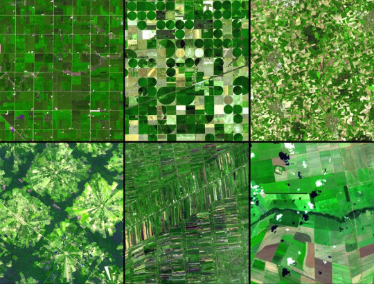
Landsat images I like from the Floating Forests project on Zooniverse #1
1 note
·
View note
Text
Poslední bílá místa z map nesmazali mořeplavci nebo archeologové, ale Virginia Norwood
Jako žena, vynálezkyně a průkopnice přitom na své pouti musela prošlapávat mnoho nových cest. Jak se jí to povedlo?

Ve 40. letech, tedy v době, kdy na této univerzitě ještě neměli ani koleje pro dívky a v kolejních jídelnách směly dívky jíst jen na pozvání mužského osazenstva, Virginia vystudovala matematickou fyziku na MIT. Studia dokončila v roce 1947, jenže si - jako žena - nejprve nemohla najít odpovídající práci. Zatajovala svůj titul, aby mohla pracovat v obchodu s módou.
Naštěstí o rok později spolu s manželem nastoupili do zaměstání ve vývojových laboratoří Spojovacího sboru americké armády. Rychle se prosadila, když přišla s nápadem na radarový odražeč, který měl měřit rychlost větru ve vysokých výškách.

Díky jejímu návrhu bylo možné měřit a předpovídat chování větru ve výškách až 30 kilometrů. Patent na něj obdržela v pouhých 22 letech. Ale to byl jen začátek.

Postupně získávala ostruhy a v roce 1953 nastoupila do oddělení výzkumu a vývoje v Hughes Aircraft, jako vůbec jediná žena z 2700 zaměstanců. Právě v Hughes Aircraft naplno rozvinula svoje úžasné schopnosti. Se svým týmem tu vyvíjela nejrůznější typy antén a zařízení.

Jedno z nich, umístěné na první komunikační družici Syncom 2, umožnilo vůbec první obousměrný satelitní hovor mezi hlavami státu (Kennedy ve Washingtonu volal premiérovi Nigérie Abubakaru Tafawa Balewovi v Lagosu).

Další družice Syncom 3 byla pro změnu použita k prvnímu televiznímu přenosu olympijských her v Tokiu přes satelit do USA.

Díky svým zkušenostem se později podílela na vývoji vysílačů umožňujících spojení mezi Zemí a sondou Surveyor. Rolí sondy bylo přistát na Měsíci a dodat potřebná data pro plánované mise programu Apollo.
Jen pár měsíců po přistání Surveyoru začala Virginia s úvahami nad zcela novým přístrojem, díky kterému se proslavila a získala i svoji pozdější přezdívku.

NASA a Americká geologická služba USGS totiž tou dobou plánovaly vyslat družici zaměřenou na pozorování Země, určenou čistě pro civilní použití.

Narozdíl od jejich záměru - snímat Zemi pomocí upravených televizních kamer a přenášet signál analogově k Zemi - Virginia přišla s velmi odlišným, ve vesmíru nikdy nevyzkoušeným technickým řešením.
Chtěla totiž používat vícespektrální snímač MSS. Ten by snímal jednotlivá pásma elektromagnetického záření odpovídající různým vlnovým délkám, a získával tak o Zemi pod sebou mnohem více informací.
Jedno pásmo by například umožnilo studovat kvalitu vody, jiné by odhalilo zralost plodin, třetí by mohlo ukázat absorpci chlorofylu a další by se dala použít k určení vlhkosti půdy nebo hustoty sněhové pokrývky.
Kvůli oběhu družice okolo planety od severu k jihu by byla Země pod ní rozdělena do pruhů, které by se po jednotlivých pásmech snímaly. Velkou revolucí rovněž byl převod informace do digitálního signálu. Jednotlivá pásma by se pak mohla skládat dohromady nebo používat zvlášť.
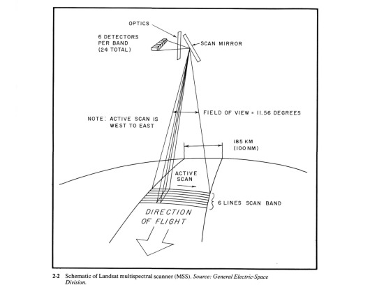
Virginia věděla, že spektrometry zemědělci už používají při leteckých pozorováních, ale aby byla schopná s tehdejší technologií zabírat rychle po sobě pruhy země, musela přijít s řešením, kdy pro každé pásmo měl měřící přístroj různá čidla.
Světlo k nim postupně pouštělo speciální pohyblivé zrcadlo, které se mohlo pohybovat tam i zpět. Díky mikrogravitaci mohlo beryliové zrcadlo létat uvnitř přístroje a zařízení bylo odolné a lehké zároveň.

Jenže ani v NASA, ani v Geologické službě nápadu příliš nevěřili. Zadali proto týmu Norwoodové sestrojit prototyp, který by ještě na Zemi tuto technologii ověřil. Kvůli přísným požadavkům prototyp nakonec oproti šesti navrhovaným pásmům snímal pásma čtyři.
Aby přesvědčili týmy v NASA a USGS, s prototypem vážícím pouhých 48 kilogramů umístěném v náklaďáku pak její tým jezdil po Kalifornii a fotil krajinu. Výsledky byly slibné.
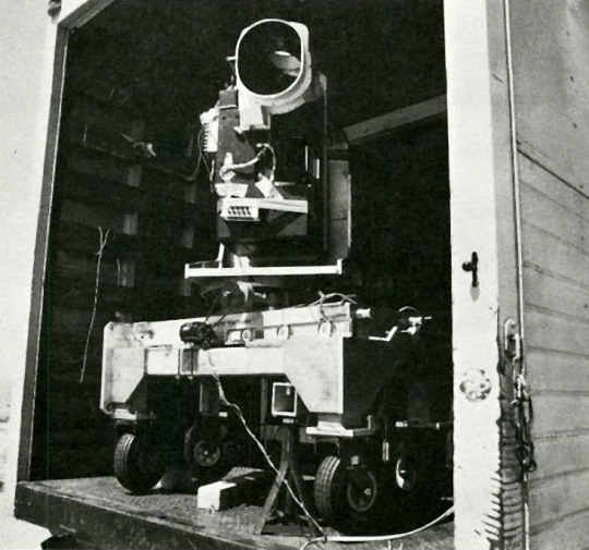
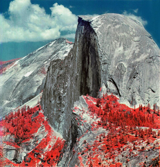
Přesto v NASA rozhodli, že na palubě bude jak Virginiin MSS, tak analogové kamery RBV, se kterými měli více zkušeností z programu Apollo. (v porovnání je snímek z RBV ten níže)

Úsilí vyvrcholilo 23. července 1972, kdy byla úspěšně vynesena družice ERTS na oběžnou dráhu s oběma přístroji na palubě. A o dva dny později byly k vidění první snímky. I ti největší pochybovači byli výsledky naprosto ohromeni!
Kvalita snímků z MSS zcela předčila veškerá očekávání. Kvůli vlastnostem oběžné dráhy družice mohl vícespektrální snímač osnímkovat celou planetu za pouhých 18 dní.
Přístroj týmu Virginie Norwood se natolik osvědčil, že jeho vylepšené verze se objevily na palubě dalších čtyř generací družic z programu, který po přejmenování nese jméno Landsat.
Její píle, odvaha a důmysl tak umožnily lidem pozorovat svět jako nikdy předtím, lépe chápat jeho proměny a smazat z map poslední bílá místa.
Virginia Norwood, “Matka Landsatu”, které můžeme být za mnohé vděční zemřela před měsícem ve věku 96 let. Děkujeme!

Zdroj: https://twitter.com/JanLukacevic/status/1653103108560486402
1 note
·
View note
Text
Chinampas milenarias en Ciudad de México
10 de septiembre de 2022
Rodeado de montañas y volcanes, el valle de México fue alguna vez la cuenca de un grupo de cinco lagos conectados que sirvieron como telón de fondo para antiguos imperios y ciudades-Estado, incluyendo Teotihuacán (800 a.e.c. a 800 e.c.), el Imperio tolteca (950 a 1150 e.c.) y el Imperio azteca (1300 a 1521 e.c.).
Entre estos lagos se encontraba el lago Xochimilco, que…

View On WordPress
0 notes
Text
Sapequinha que conhece no Badoo
Brunette MILF Elexis Monroe Makes Alaina Dawson Cum
Indian teen girl outdoor sex by texi driver
Rugged Daddy Double gay fuck threesome
Teen caught by Step mom with fuck lesson
Bbw huge tit wife riding my dick and big creampie
Anal Fucking Hot Teen with Dick and Anal Beads in Norway
Officer sits and watches as he makes Gracie May strip her clothes off
Amateur Teen Swingers Having Fun
Hot daughter get fucked by her dad
#intershot#overfluent#nosologic#hoydening#postcaval#vasosection#favel#priest-led#dancing-girls#Sinify#landsat#well-stored#free-reed#nail-tailed#overspeedily#Bruceville#chemosmosis#conversational#topography#Codi
0 notes
Text
Hi
I'd like to commandeer my current blog to show y'all the satellite imagery I've seen. I work in flooding, so I have the opportunity to look at past major events like in Sudan during 2021 and in Ghana during 2020. This is in false color imagery which I can go in more depth to on another post, but this would not be how we see the image with our eyes.
I recognize I am showing images of devastation. So I always want to be respectful of the likely tragedy that occurred in these areas. However a majority of these locations are in flood plains which the worlds population is increasingly moving more into (Tellman, et. al 2021). So I think images like this will only become increasingly relevant. I hope this is more for the purpose of bringing attention to what tools we have available to map flooding in an effective manner in the face of climate mitigation. Ok thanks for reading. <3

0 notes
Photo
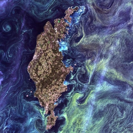
Reposted from @nasa Gogh big or Gogh home. 🖼 In the style of famous artist Van Gogh's painting Starry Night, massive congregations of greenish phytoplankton swirl in the dark water around Gotland, a Swedish island in the Baltic Sea. Phytoplankton are microscopic marine plants that form the first link in nearly all ocean food chains. Population explosions or blooms of phytoplankton, like the one shown here, occur when deep currents bring nutrients up to sunlit surface waters. The sunny nutrient-rich waters fuel the growth and reproduction of these tiny plants. In addition to its picturesque quality, Landsat satellite data collected through observations contribute to our understanding of Earth. From measuring the speed of Antarctic glaciers, to tracking water use in crop fields in the western United States, to monitoring deforestation in the Amazon rainforest—Landsat helps us better understand our changing planet. Image Description: Reminiscent of the swirling oil-on-canvas look of a Vincent Van Gogh painting, the dark navy, teal, and blue eddies around Gotland combine with the green and yellow blooms of phytoplankton to create a portrait of the area from orbit. Gotland island narrowly bisects the center of the image upward, surrounded by the colorful Baltic waters. Its fields and forests appear in shades of warm greens. On the island's western coast, a small area of grey highlights the county capital of Visby. Credit: @USGS/NASA/Landsat 7 #NASA #Earth #Ocean #Water #Island #VanGogh #Art #Space #Landsat #BalticSea #Sweden #Gotland #Fårö #Karlsö #Visby#eugenelacroix1 @eugenelacroix1 #photography https://www.instagram.com/p/CkGCIzMoR1u/?igshid=NGJjMDIxMWI=
#nasa#earth#ocean#water#island#vangogh#art#space#landsat#balticsea#sweden#gotland#fårö#karlsö#visby#eugenelacroix1#photography
0 notes
Text

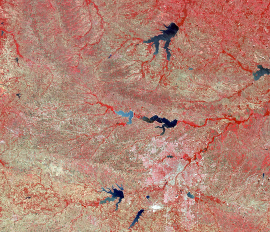
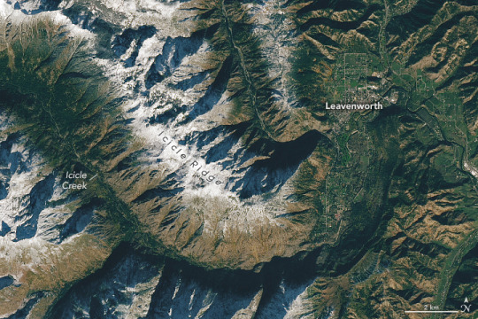
The Snowshoe Lava Field part of the Mount Edziza volcanic complex in British Columbia.
7 notes
·
View notes
Photo
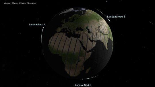
Trio of smaller satellites to continue NASA/USGS's Landsat legacy With a trio of smaller satellites that can each detect 26 wavelengths of light and thermal energy, the Landsat Next mission is expected to look very different from its predecessors that have been observing Earth for 50 years. This new plan for Landsat Next, a joint mission of NASA and the U.S. Geological Survey (USGS), is designed to provide more frequent, and finer resolution, data of the changing surface of Earth. "I think this is going to be a phenomenally capable instrument, with the biggest leap in Landsat capability since Landsat 4," said Bruce Cook, NASA Landsat Next Project Scientist at NASA's Goddard Space Flight Center in Greenbelt, Maryland. "This is basically the first chance we've had to completely re-conceive the Landsat mission." The Landsat series of satellites has provided a continuous record of Earth's surface from space since 1972, allowing researchers and resource managers to track changes in the natural and human-influenced environment. Landsat Next, planned to launch by late-2030, will extend this record while providing more frequent observations, higher resolution images, and more than twice the spectral bands as its predecessors. Earlier this month, NASA officials approved Key Decision Point-A authorization for the mission. Landsat 9, which launched in September 2021, is a single spacecraft that collects data of Earth's landscapes and coastlines every 16 days. Its sister satellite Landsat 8 is also in orbit, and together they gather images of any given spot on Earth's surface every eight days. NASA and USGS envision a Landsat Next constellation of three spacecraft, orbiting in a configuration that would provide finer spatial resolution and expanded spectral imaging capabilities every six days at the equator. When combined with Landsat 9, heritage Landsat image data would be provided at even higher temporal frequencies, Cook said. These more frequent observations are especially important for tracking fast-changing processes like water quality, crop health, and natural hazards. Landsat Next will also gather higher-resolution, more detailed images of Earth's surface. Pixels from Landsat 8 and Landsat 9 are 98 feet (30 meters) wide, about the size of a baseball infield, in most wavelengths. For most Landsat Next wavelengths, pixel size will be 33 to 66 ft (10 to 20 m) wide, about the width and length of a tennis court. The three spacecrafts that make up Landsat Next will be identical, each carrying an instrument or instruments that detect 26 wavelengths spanning the visible to shortwave infrared and thermal infrared regions. This is more than double the spectral bands of Landsat 9, and is designed to allow data users to glean even more information, Cook said. New spectral bands were added to Landsat Next in response to evolving science and user needs. For example, new visible bands will help scientists and resource managers manage water quality by identifying chlorophyll or dissolved organic material in the water, as well as harmful algal blooms. Red edge and shortwave bands will help identify stress in forests or croplands. New near infrared and shortwave bands will provide information about snow and ice surface states, water content and freeze-thaw dynamics in a changing climate. Landsat heritage spectral bands have also been refined. For example, Landsat's SWIR2 band was subdivided into three bands to advance agricultural management and the impact of crop residues on soil fertility, crop productivity, and carbon sequestration. Landsat Next will also increase the number of thermal infrared bands from two to five, which will provide measures of surface emissivity, improve estimates of surface temperature, and help with mapping minerals. "One of the things that we've really focused on in the Landsat Next project is listening to the user community," said Chris Crawford, USGS Landsat Next Project Scientist and Co-Lead of the Landsat Science Team. "At the same time, we're still coming back to data continuity as a guiding observational principle and guaranteeing that no matter what future Landsat missions look like, they maintain continuity and compatibility with the prior historical record. Because that's really the strong, unique attribute of Landsat: 50 years of measurements that we hope to carry into the next 50 years."
3 notes
·
View notes
Photo
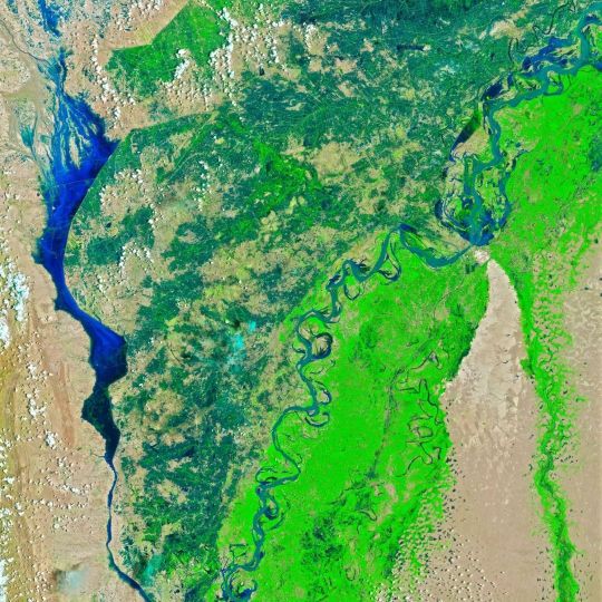
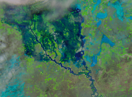
Devastating Floods in Pakistan Since mid-June 2022, Pakistan has been drenched by extreme monsoon rains that have led to the country’s worst flooding in a decade. According to Pakistan’s National Disaster Management Authority, the floods have affected more than 33 million people and destroyed or damaged more than 1 million houses. At least 1,100 people were killed by floodwaters that inundated vast areas of the country. The worst flooding occurred along the Indus River in the provinces of Punjab, Khyber Pakhtunkhwa, Balochistan, and Sindh. Between August 1–26, Sindh received 443 millimeters of rain, more than 780 percent of average. The false-color images above were acquired by the Landsat 8 and Landsat 9 satellites on August 4 and 28, respectively. The images combine shortwave infrared, near infrared, and red light (bands 6-5-4) to better distinguish flood waters beyond their natural channels. Pakistan last faced such dramatic and widespread flooding in 2010. #Landsat #NASA #USGS #Earth https://www.instagram.com/p/Ch7W2EqNMJh/?igshid=NGJjMDIxMWI=
0 notes
Text
50 years of Landsat
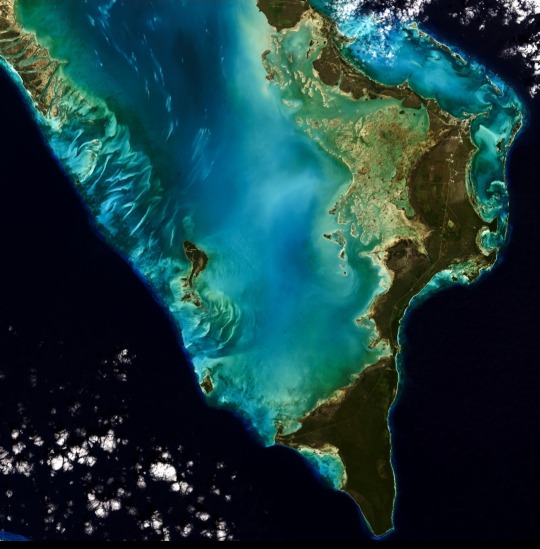
We're celebrating 50 years of the Landsat satellite, the first of which launched on July 23, 1972. The latest in the series, Landsat 9, launched in September 2021.
Landsat shows us Earth from space. For 50 years, the mission has collected data on the forests, farms, urban areas and freshwater of our home planet, generating the longest continuous record of its kind. Decision makers from across the globe use freely available Landsat data to better understand environmental change, manage agricultural practices, allocate scarce water resources, respond to natural disasters and more.
This natural color image of Eleuthera Island, the Bahamas, was taken by Landsat 9 on January 18, 2022. Between Landsat 8 and Landsat 9, the Landsat program delivers complete coverage of the Earth's surface every eight days.
Image Credit: Michelle Bouchard using Landsat data from USGS Landsat
Via the NASA app
*** Please don't remove my tags.
0 notes


Last Seen Blogs

darkwoodjewelry
DARKWOOD JEWELRY

reformistcall
عقيدة الدولة السعودية

stevenspielbergchronicles
STEVEN SPIELBERG CHRONICLES

wickedquecn
𝚋𝚘𝚠 𝚝𝚘 𝚝𝚑𝚎 𝑸𝑼𝑬𝑬𝑵