#Map of New York
Text
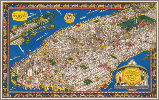
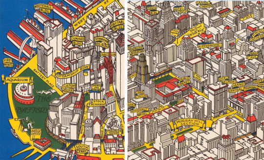
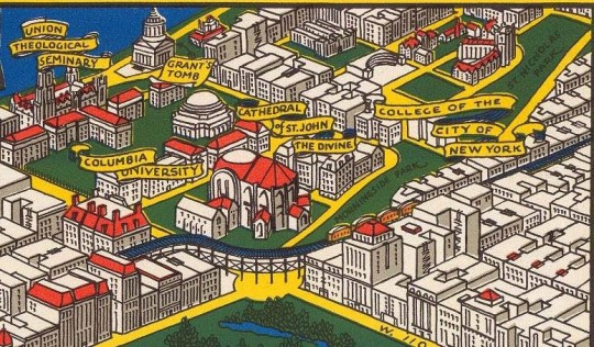
C.V. Farrow drew this beautiful map of what he called "The Wondrous Isle of Manhattan" in 1926. You MUST enlarge it. It wasn't intended to be used for navigation, but rather as a pictorial representation of the island's highlights. Below are a few details that show you what the full-size map is really like. You should enlarge them, too!
Source: Gothamist
#vintage New York#1920s#C.V. Farrow#map#vintage Manhattan#Jazz Age#Roaring 20s#1920s NYC#illustration#pictorial map#colored map#vintage NYC
2K notes
·
View notes
Photo
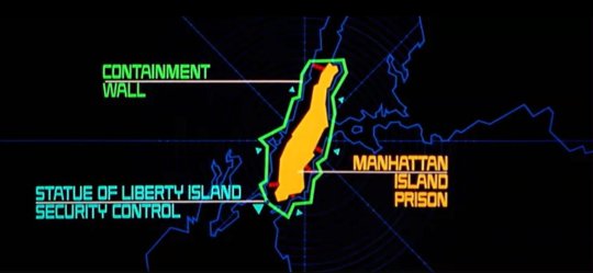
Manhattan Island Prison, from "Escape From New York", set in a dystopian 1997
440 notes
·
View notes
Text

Not sure if I'll end up finishing this but!! Lol. Turtle designs.
Might redo all of the lineart actually. Cuz i'm silly and i found techniques I like way more. Gonna sound crazy but some digital brushes feel physically weird. Like I feel physical sensations when using them and that's how I judge digital brushes/pens.
#tried mapping pen on csp. after lining all of this i learned i dont like the mapping pen on csp and im gonna change it heavily.#majart#teenage mutant ninja turtles#tmnt#tmnt au#tmnt heroes of new york#tmnt leonardo#tmnt raphael#tmnt donatello#tmnt michelangelo#leonardo hamato#raphael hamato#donatello hamato#michelangelo hamato#au#alternate universe#au art#fanart#wip#i want a brush that is thin but not thin. thick but not thick. and so far sketch/pencil pens work the best.#i want cleaner lineart but my eyes and wrists HATE THE MARKER/PEN BRUSHES. THEY FEEL OFF.
168 notes
·
View notes
Text


View in full resolution
After almost six months of work, I'm proud to finally present my integrated commuter rail map of New York City and Philadelphia!
Showing five different commuter rail systems (CT Rail, Metro-North, LIRR, NJ Transit, and SEPTA), this map depicts everywhere a passenger can get to by train from NYC or Philadelphia without using Amtrak.
This is by far the most complicated map I've ever made, but I'm incredibly happy with the result! I'm planning to write some notes on the process of making this, but for now, I'm just proud that it's finally done.
#trains#transit#maps#amtrak#nyc#philadelphia#ct rail#mta#metro-north#lirr#nj transit#septa#new york#new jersey#connecticut#pennsylvania
324 notes
·
View notes
Text
First, second, and third most spoken language in New York City 🗽🚇🌭 and Los Angeles County 🌴⭐️🌆
#map#maps#cartography#usa#data#geography#americas#latin america#langblr#languages#language#new york city#nyc#los angeles#la#new york#california#united states#diversity#chart#history#spanish#chinese#english#east coast#west coast#lana del rey#russian#armenian#french
208 notes
·
View notes
Text
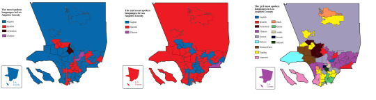
Appalachia in its entirety
Map of Appalachian subranges (I consider Appalachia to be anything in the Appalachian Mountains so; Maine, New Hampshire, Vermont, Massachusetts, Connecticut, New York, New Jersey, Pennsylvania, Ohio, Maryland, West Virginia, Virginia, Kentucky, Tennessee, North and South Carolina, Georgia, and Alabama)
#appalachia#America#Americana#appalachain mountains#appalachian gothic#southern gothic#map#geography#pennsylvania#ohio#Massachusetts#tennessee#north carolina#south carolina#connecticut#new york#georgia#kentucky#virginia#west virginia#lake eerie#the berkshires#the Alleghenies#ok idk how to spell that one lol#it autocorrected to the Alamo so idk what to do#the Catskills#oh fuck it why not#the alamo#the Texans are mad#let them be
129 notes
·
View notes
Photo
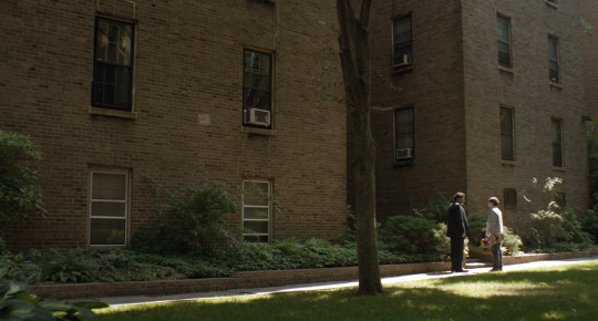

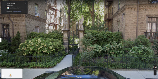
Love is Strange
Ira Sachs. 2014
Apartment
3327 80th St, Queens, NY 11372, USA
See in map
See in imdb
#ira sachs#love is strange#alfred molina#charlie tahan#jackson heights#queens#new york#united states#apartment#the towers#sphinx#movie#cinema#film#location#google maps#street view#2014
70 notes
·
View notes
Note

Thoughts on this? (You mentioned awhile ago that you want ppl to send you interesting maps; I’m happy to oblige)
Love the fact California is split. Bakersfield is not the worst (I am biased because Dwight Yoakam)
In my opinion: The worst city in Michigan is Grand Rapids, the worst city in Arizona is Tempe, the worst city in Massachusetts is Boston, and the worst city in New York is NYC (this is purely a joke because I have family in all these cities. I actually really love my family)
Socal and NorCal are two different states and there for two different people confirmed. Thank you for map, map is brain fuel
#wttt#wttt fandom#welcome to the table#welcome to the statehouse#wttt california#wttt headcanons#wttt fanfic#wttt texas#wttt florida#wttt new york#wttt maps#ask
34 notes
·
View notes
Text
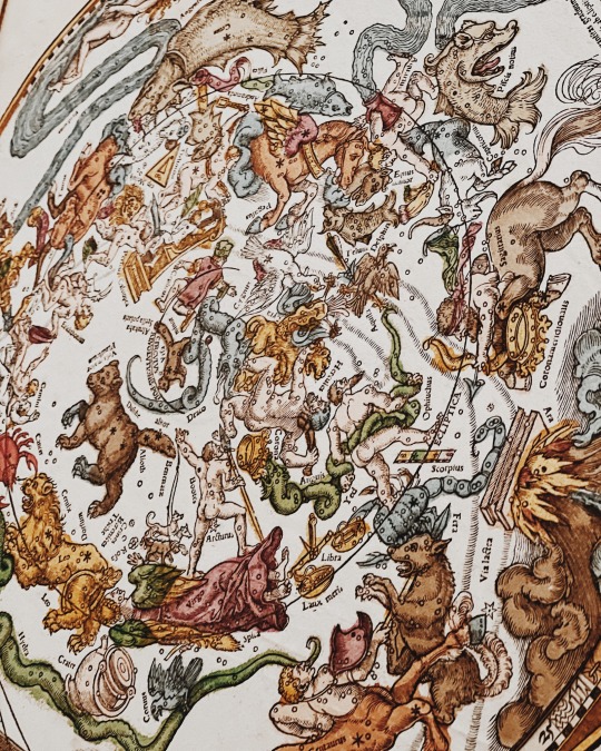
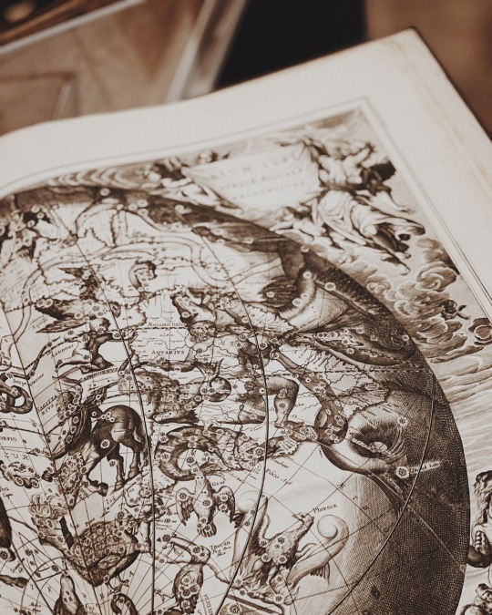
celestial atlases at the NYPL xx
#old books#rare books#nypl#new york public library#celestial atlas#star map#1500s#1600s#16th century#stars#Astronomy#mine#my photos#dark academia#dark academia aesthetic#art academia#light academia#academia aesthetic#queue
244 notes
·
View notes
Text
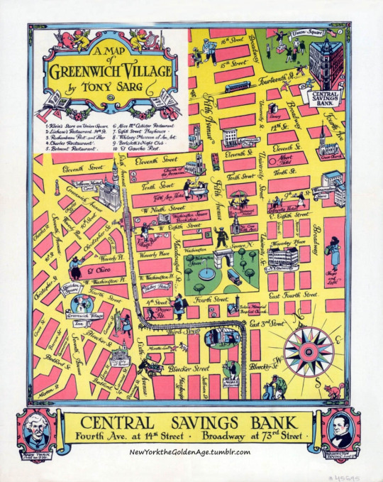
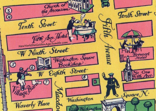
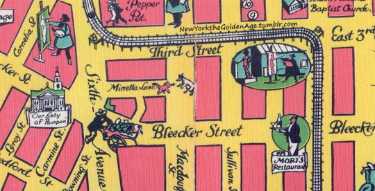
A hand-drawn and painted map of Greenwich Village (or part of it), made for the Central Savings Bank in 1934. Tony Sarg, who created it, was a member of the Salmagundi Club, and the original still hangs in the club's headquarters at 47 Fifth Avenue, between 11th and 12th Streets.
Photo: Gotham to Go
#vintage New York#1930s#Greenwich Village#map#Central Savings Bank#hand-drawn map#Tony Sarg#illustration#Salmagundi Club
114 notes
·
View notes
Photo
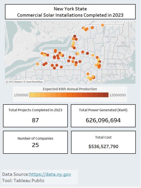
NYS Solar Installation 2023
by u/Impossible-Cycle5744
64 notes
·
View notes
Text
My stress dreams mostly take the shape of navigating unnavigable spaces, but the space is consistent across dreams. They are real places except utterly unreal. False cities.
new york city, in my dreams
A vast city of brownstones with no end, but I always find myself on the same street with green trees casting a dappled shade over ever thing. It’s dense with low those red brick houses and parked cars.
If you walk down the steps to the basement of the houses you would find vast unmarked shops, empty in their centre, and customers crowded into corners. If you were to walk up the steps into a home it would be empty. All white walls and narrow rooms.
There is a train in this city, if you are able to find it’s entrance. It’s a gash in the ground where the packed streets converge into a spiral. You enter impossibly deeper and deeper inside it. It’s hard to leave once you enter.
The walls are white brick. The platforms are white brick. The maze of hallways and stairs descends deeper to a network of too many train lines. You descend stairs to platforms merely ten feet long or a different set of stairs to a platform that stretches impossibly long into the dark. The tracks and platforms intersect haphazardly, and if the trains didn’t run quite on time you know they would run each other through.
If you get on a train, you can take it to the outer reaches of the city. I have not gotten off in the north, but I’ve seen the landscape out the train windows. It is made of small sandy islands that the train stays far above. It takes a long slow and circuitous route. The train rarely stops, just passes over places that desperately need it to stop there. There are so many train lines but they so rarely share stations with one another. A passenger has no choice but to ride a trains long winding two hour route to their destination.
In the South, the train moves around a neighborhood set into the curve of a mountain. There is only station here, and when you exit you take a long winding path down the mountain into the neighborhood. The houses and streets are as tightly packed as they are in the city centre, but here they are built into the curves of the mountain. It’s hard to distinguish between plant, brick, house, and geology. It’s also where all the interesting people doing thankless work live.
Walking north from mountainous neighborhood, you approach the southern beach. There is a long, flat, wide bridge only slightly above the water level, made from planks of wood. It has no guardrails. It is essentially a massive boardwalk. Next to the bridge is a set of train tracks level with the water, but no train comes here anymore. Following the boardwalk takes you to a small flat island of sand. You could walk from side to side in under five minutes but it would take an hour to walk the length. There are houses here too, uncomfortably far apart from one another and fading into a haze of heat and pollution. This is the only place you can afford to live. It’s entirely exposed. It will be washed away in the next storm.
#i wrote out these dream cities several years ago so i could remember them clearly and map them#i have one for Philadelphia too#New York and Philadelphia and the Montreal Airport are my big three reoccurring dream spaces#text
30 notes
·
View notes
Text


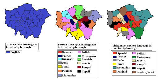
First, Second, and Third most spoken languages in New York City🗽, Los Angeles🌴, and London🕰️
#map#maps#cartography#usa#data#europe#americas#geography#latin america#new york#new york city#nyc#la#los angeles#london#uk#united kingdom
175 notes
·
View notes
Text

my proposal to fix the "united states of america" issue once and for all
156 notes
·
View notes
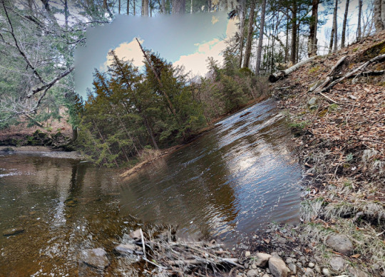
Photo
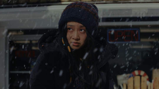
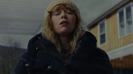
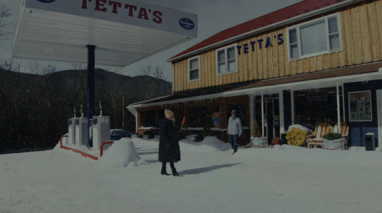
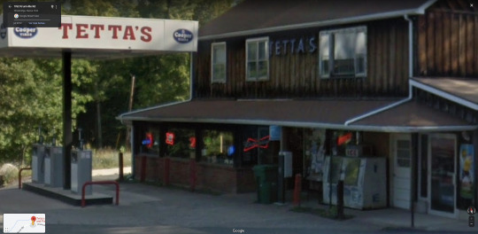
Poker Face
Rian Johnson. 2023
Tetta’s Gas Station
2082 Co Rd 3, Olivebridge, NY 12461, USA
See in map
See in imdb
#rian johnson#poker face#natasha lyonne#stephanie hsu#gas station#new york#hudson valley#snow#movie#cinema#film#location#google maps#street view#series#2023
40 notes
·
View notes
Last Seen Blogs

diyasuper-blog
Untitled

paige-mcquillan-blog
Wonder.

sparklyslug
Come Be We And We Be Free

beautifulmars
BEAUTIFUL MARS