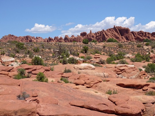
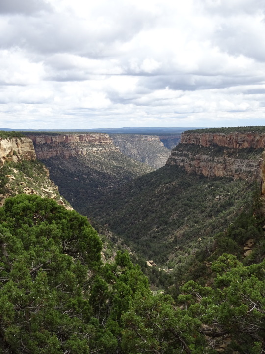
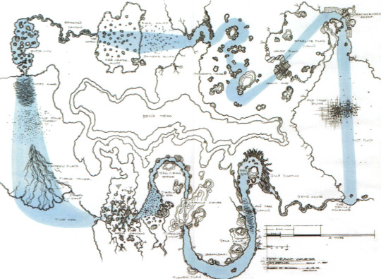
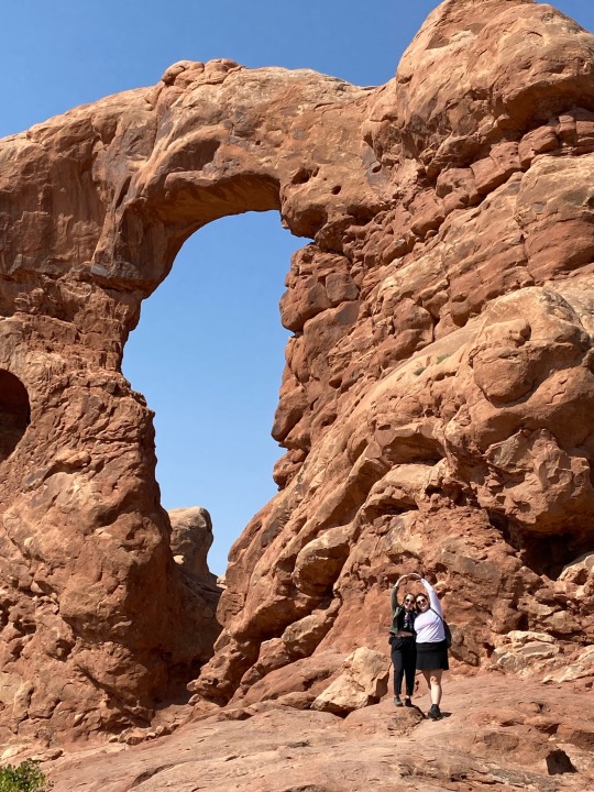
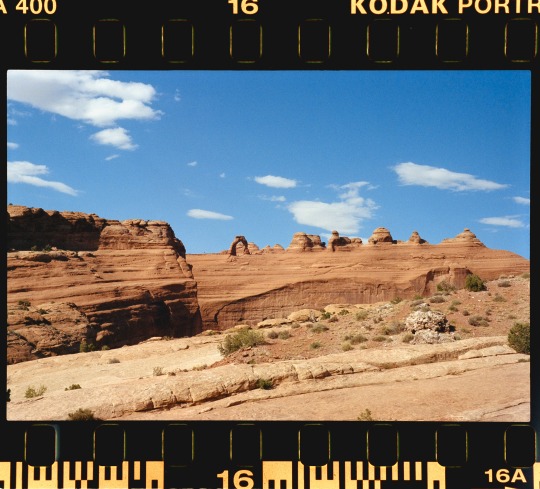
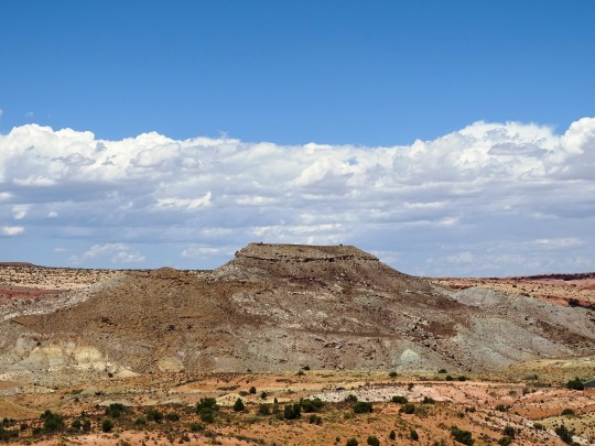
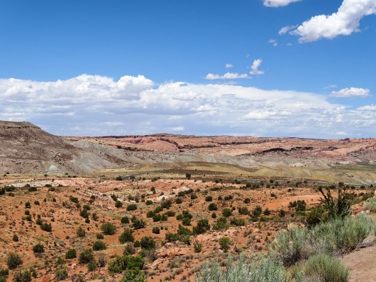
#Mesa Arch Area
Photo


Geologists’ Day
Don’t take the ground beneath your feet for granted: honor the scientists that have delved into the Earth to teach us more about it on National Geologist’s Day.
For many people, geology could be considered an underappreciated science. This may be especially true when it is compared to other sciences such as physics, biology or chemistry. However, if the human race didn’t have geologists, then we wouldn’t know how the earth was formed!
Geologists’ Day dedicates this time towards thanking them for all the research they do to help further understand how our world works.
Not only that, but this day also seeks to learn about historical geologists that have helped people understand our world better and even possibly inspire some people to become geologists themselves!
History of Geologists’ Day
Geology, or the study of the composition of rocks, soil and other materials, has been around since the times of Ancient Greece. In their pursuit of understanding the world around them, Greek scientists, who wondered how the rocks were formed, began studying fossils and generating theories to go along with their ideas and research.
Later, during the Middle Ages, when science was thought to have challenged the Catholic Church, more advances came (albeit sometimes subversively) in the field of geology. During this time, Leonardo da Vinci explored the functions of the human body but also, one of his lesser-known pursuits, is that he became a pioneer in geology.
One of da Vinci’s interesting lines of research was related to fossils. He concluded that the fossils he and others had found embedded on mountain tops must have been from animals that swam on an ancient sea bed, though none of them were exactly sure how they could have gotten there.
During the 17th-century, scientists began to make important links between certain sedimentary deposits in the oceans and the strata observable in rock formations. Much of the explanation as to how that happened, however, continued to remain a mystery until James Hutton and William ‘Strata’ Smith came along.
These two well-known geologists helped find the explanation of the earth’s long and slow development over the course of thousands of years. Smith was also credited as the creator of the first, geologically detailed, national map of any country in the world. In this case, the country was England and he has since become known as the ‘Father of English Geology’.
Geologists’ Day, itself, was actually the idea of a group of well-known Soviet geologists who established it in April, 1966. The day was chosen in the spring because it notes the end of winter and is a time that ramps up to the summer season field work when geologists are so active.
While it continues to be a favorite day of the Russian Mineralogical Society, the day eventually made its way beyond the former Soviet Union and began to be celebrated by geologists, geophysicists and geochemists in various places in Europe, the United States and other countries around the world.
How to Celebrate Geologists’ Day
Typically held on a Sunday, the celebration of Geologists’ Day can be fun for professional rock lovers and hobbyists alike! This day strives to help further the study of how the earth came to be. Geologists’ Day is all about learning the history of the earth, the geologists who studied the earth, and helping to inspire people out there to study geology.
Consider the following ways to celebrate the day or come up with other creative ideas:
Learn More About Geology
Give a nod to Geologists’ Day by learning a bit about what the discipline of geology is and how it works. Digging in rocks, observing maps, and studying how they all came to be is what a geologist’s job is all about. Make use of these online resources to learn more about geology:
The Geological Society of America
International Association for Promoting Geoethics
Society of Economic Geologists
Those who are even more interested might take the time to join a few online classes to further their studies. Take a look into the history of geologists, what they believed about the earth at the time they lived. If it turns out there’s an inner rock-lover in there, just waiting to get out, why not go for a degree while you’re at it?!
Show Appreciation to a Geologist
Geologists’ Day aims to show appreciation for the geologists that continue to study rocks and all their formations.In fact, this is the perfect day to gather with some friends or family to thank some of those favorite geologists, or even just a science teacher, who may have made a difference in the understanding of the world we live in.
Listen to a Geology Themed Playlist
Hop onto Spotify or another favorite music hosting site and enjoy these songs that are reminiscent of the study of the earth, rocks, landslides and all the beautiful things that go along with geology:
We Will Rock You (1977) Queen
The Geologists are Coming! (2017) The Amoeba People
Landslide (1975) Fleetwood Mac
The Petroleum Age (2011) Philip Gibbs
Geology Rocks (2017) Los Beekeepers
Uranium Rock (1973) Warren Smith
Sweet Geology (aka The Mineral Song) (2007) The Akkademiks
Share Geology Day with Friends
Show appreciation for the studies of geologists by sharing this holiday with friends and family. Go big by throwing a geology party, or keep it small by simply gifting friends or coworkers with a small stone or rock as a token of the day. Whatever method is chosen, just the acknowledgment of this day is a step in the right direction toward appreciating the earth and its scientists!
Source
#Dinosaur National Monument#Split Mountain#Colorado National Monument#Upper Colorado RiverScenic Byway U-128#Arches National Park#Canyonlands National Park#Wolf Creek Valley#Mesa Verde National Park#Monument Valley Navajo Tribal Park#Glen Canyon National Recreation Area#Earthquake Fault#Mammoth Lakes#Geologists’ Day#first Sunday in April#2 April 2023#GeologistsDay#USA#summer 2016#Rocky Mountains#landscape
5 notes
·
View notes
Text

The course is outlined in blue—it starts in the upper right-hand corner at the arena; proceeding counterclockwise to the Waldo Grade, which was an elevation change; next is Mushroom Mesa, which is followed by Ricks Rise, an elevation drop; a sharp left turn brings them to Ebe Crater, a big flat area with sinkholes that leads to the narrow slot through which is the curvy Beggar's Canyon; this leads to the Dune Sea portion of the race, but that was deleted; next is Arch Canyon, which leads to Jag Crag, where all the stalagmites and stalactites are, which goes into Lagulla Caves-where Rats Tyrell blows up; next is Tusken Turn, where the Raiders snipe at the Podracers. The last stretch is Hutt Flats, where Sebulba crashes.
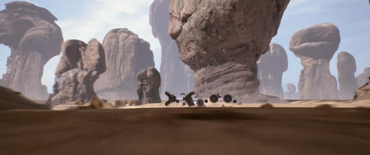
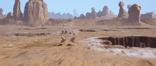


the podrace sequence in phantom menace is admittedly long, but it also very visually exciting and uses many pretty environments. the combo of miniatures, matte paintings, and cgi works imho to make a convincing backdrop for the race. it's interesting to see it all broken down into the sequence, and fun to identify what part is the infamous beggar's canyon that luke flew through.
23 notes
·
View notes
Text
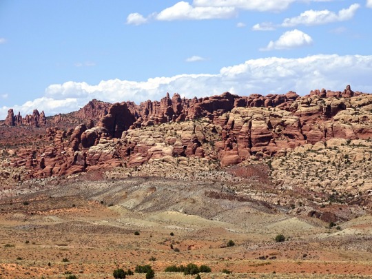
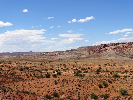
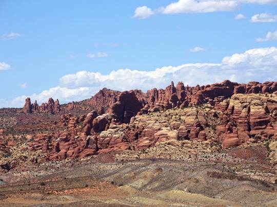
An overview: Moab pt 2
I arrived at a good time of year, as July and August are the hottest months for the area. Tourist season is known to be the months of May and October. The weather is mild then, but the crowds are plentiful. I hadn’t realized that people from all over would be visiting, considering it took me so late in life to learn about it! Parked behind my tow trailer the first night was a converted semi-truck full of about 50 people from Germany touring the U.S. The main reasons for this would be the National Parks. Southern Utah has what is known as The Big or Mighty Five: Zion and Bryce Canyon toward the west side of the state, Capitol Reef more in the center, and Moab’s own Canyonlands and Arches. Delicate Arch, found in Arches, is the image of what most people think for Utah, being on the license plate and on several versions of the Utah quarter. I visited both Canyonlands and Arches twice, and Capitol Reef once, so I can speak for those but not the others yet. Unpopular opinion, but Canyonlands, slightly southwest of Moab, is my favorite of those three. The vast sights, the deep canyons, the wildlife, the diversity in colors of the rocks, and the hikes along the rims are breathtaking. It’s a large park, which I didn’t realize before my first visit, and it is separated into districts. I have only visited the Island in the Sky district, and the White Rim Overlook trail was a fantastic choice if you can only do one there. I also hiked the Mesa Arch trail, which is another famous spot in the state, as well as Grandview Point. There are plenty of pull offs along the main drive to see the views if not hiking, and there are more difficult hikes, as well as some back country hiking, which I plan to make it back there for. While visiting I was ecstatic to just drive and see the crows, ravens, mule deer, and lizards. The most popular park, next to Zion, is Arches, named for being home of over 2,000 natural stone arches. During the busy time of year, Arches requires a timed entry reservation to enter between the hours of 7:00 am and 4:00 pm. I always made sure to get there well before 7, as the crowds have already started early to take in the phenomenal sunrise views. In addition, beating the heat was important to me. I’d make it a habit to start a hike by 5:30 am and be done for the day by 8:00 am, just to avoid the soaring temperatures. There is no shade to be found in this park. I ended up hiking to Delicate Arch twice, as I had some visitors who wanted to experience it. I think I’ve seen most of the main arches that can be accessed along the main road, and did most of the shorter hikes. Honestly, this may be controversial, but Arches NP is slightly overrated IN MY HUMBLE OPINION. Don’t get me wrong, it’s cool. Especially the first time. The rock formations are wild and most of the time it feels like you’re in Jurassic Park. I have an appreciation for it, but I won’t go out of my way to go back again. I do encourage everyone to go once and decide for yourself where it ranks! The crowds and sharing the hiking trail with so many tourists was not appealing. I’m not sure if the off season would be better, but it does get cold in that area and I’m not a cold weather hiker. Also, there is a 100 ft tall phallic-shaped rock seen from the road called “The Phallus.” If that doesn’t make you want to go, I’m not sure what will. Last, but definitely not last in ranking, was Capitol Reef. I did not have high expectations because honestly no one had given me the suggestion to go, and I didn’t hear people talk about it much. It was a bit of a drive so I stayed at a campground in Hanksville, UT. Hanksville is in the middle of nowhere, I did not have great cell service, but it was beautiful and I had a nice, refreshing time there with just myself and the dogs away from the hustle and bustle of Moab for a couple days. I was told ahead of time to make sure to get some pie while I was there, and after a bit of research I found that I needed to visit the Gifford Homestead to purchase said pie.
Go to part 3!
3 notes
·
View notes
Text
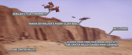
Over Metta Drop
STAR WARS EPISODE I: The Phantom Menace 01:06:47
Not sure if this should be Metta Drop between Mushroom Mesa and Ebe Crater Valley or not. If yes, then this shot is out of order with the previous scenes in Beggar’s Canyon.
But if it’s not intended to be Metta Drop, then there’s another unnamed cliff just after the exit of Beggar’s Canyon onto the Desert Plain - which may be represented with this line on the map.
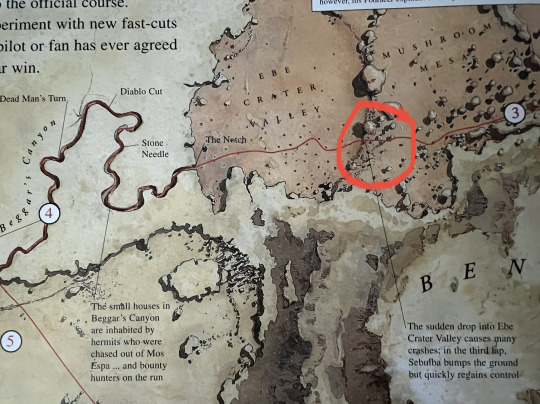
That is unless Metta Drop is intended to be the drop separating Mushroom Mesa from Ebe Crater Valley, or if it is intended to be the drop at the beginning of Desert Plain. The novelization seems to imply Metta Drop is after Jag Crag Gorge.
Pg 167 of Creating the Worlds of Star Wars 365 Days mentions a change in elevation called "Rick's Rise", which wasn't carried over into the Complete Locations map. (Thanks to Thomas Hansen on Twitter for sending this version of the ILM map)
On the ILM map, it looks like the Podrace sequence goes like this:
• Anchorhead Arena (which became Mos Espa Grand Arena)
• Starlite Flats (on Inside the Worlds/Complete Locations map)
• Waldo Road (became Waldo Grade/Waldo Flats on ITW/CL map, featured in 3rd lap in the film)
• Gavin Gap (unnamed on ITW/CL map)
• Mushroom Mesa (featured in all 3 laps in the film, and present on all maps)
• Boulder Bluff (not featured on ITW/CL map or the film?)
• Rick Cliff (probably Rick's Rise mentioned in Creating the Worlds 365 - could be this drop)
• Ebe Crater Valley (featured in all 3 laps in the film, and present on all maps)
• The Notch (featured in all 3 laps in the film, and present on all maps)
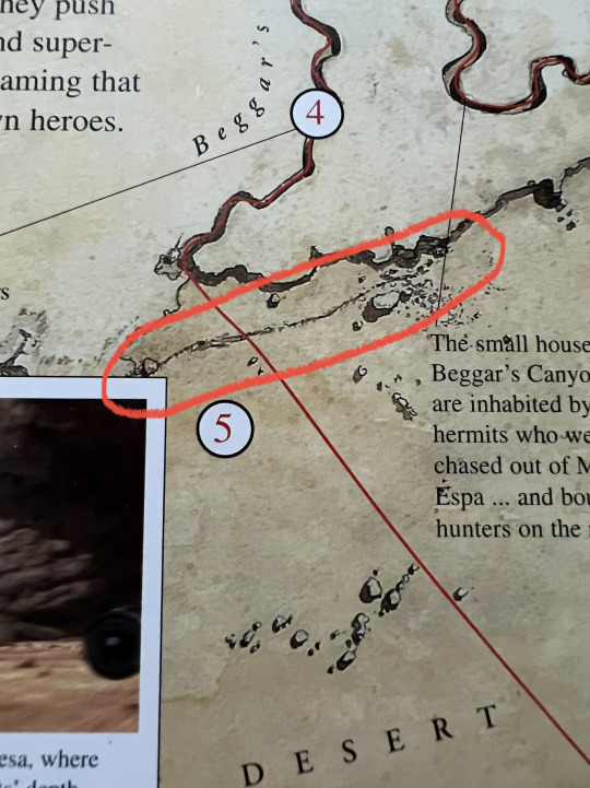
• Beggar's Canyon (featured in all 3 laps in the film, and present on all maps)
• Butte City (not featured on ITW/CL map or the film? Could be the name for the random buildings in Beggar's Canyon?)
• Bumpy Road (hard to make out the name to be sure - not featured on ITW/CL map or the film?)
• ??? Stone ??? (difficult to make out this name at all - not featured on ITW/CL map or the film?)
• Pattern Flats (not featured on ITW/CL map or the film?)
• Turtle Tower (not featured on ITW/CL map or the film?)
• Droopy Drop (not featured on ITW/CL map - could be this drop)
• Dune Sea (seems to be renamed to Desert Plain on the ITW/CL map)
• Arch Canyon (featured in all 3 laps in the film, and present on all maps)
• Diablo Spa (not featured on ITW/CL map or the film - this may have been some kind of geothermal geyser area judging by the name, cut from the race - seemingly replaced with The Whip on the ITW/CL map)
• Jag Crag Gorge (featured in all 3 laps in the film, and present on all maps)
• Lagulla Caves (renamed Laguna Caves, and the Lagulla name was repurposed for the Lagulla Ice Cave where Qui-Gon, Obi-Wan, and Jar Jar encounter a colo claw fish during their trip through Naboo's core - featured in all 3 laps in the film, and present on all maps)
• Tusken's Camp (not named explicitly, nor do we see the actual camp, but this would explain where the Tusken Raiders come from that take shots at the podracers)
• Tusken Turn (renamed Canyon Dune Turn, where Teemto Pagalies is shot down in lap 2)
• Grandaki (?) (not sure what this is, but it is located in the middle of what became Canyon Dune Turn)
• Jawa Camp (not present in the film or ITW/CL maps - would explain where the Jawas came from in the "Extended Lap 2" deleted scene)
• Alé Pass (a note included says Uphill - not featured on ITW/CL map or the film)
• Bindy Bend (not sure if this is shown in the film or not, but it is included on the ITW/CL map)
• Jill's Junction (not featured on ITW/CL map or the film?)
• Jett's Chute (featured in all 3 laps in the film, and present on all maps)
• Devil's Doorknob (featured in the last 2 laps in the film, and present on all maps)
• Hutt Flats (featured in all 3 laps in the film, and present on all maps)
• Old Town Ruins (cut from the film and not shown on the ITW/CL map)
** if you think I missed something or got something wrong - let me know!
And another map courtesy of Jon Knoles on Twitter, who worked on Episode I Racer for LucasArts.
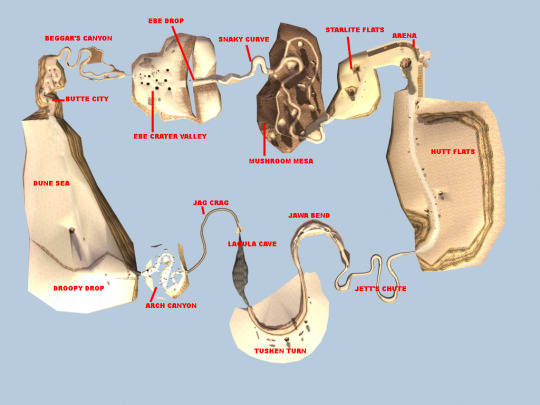
This map seems to combine a few features of the ILM map and the Inside the Worlds/Complete Locations map - and adds a few new locations.
• Arena (on ILM and ITW/CL map, shown in film)
• Starlite Flats (on ILM and ITW/CL map, shown in film)
• Mushroom Mesa (on ILM and ITW/CL map, shown in film)
• Snaky Curve (new! not shown in film)
• Ebe Drop (new! seems to be where Metta Drop or Rick's Rise would be located)
• Ebe Crater Valley (on ILM and ITW/CL map, shown in film)
• Beggar's Canyon (on ILM and ITW/CL map, shown in film)
• Butte City (on ILM map)
• Dune Sea (renamed to Desert Plain - on ITW/CL map, shown in film)
• Droopy Drop (on ILM map - could be one of the drops we see in the film)
• Arch Canyon (on ILM and ITW/CL map, shown in film)
• Jag Crag (on ILM and ITW/CL map as Jag Crag Gorge, shown in film)
• Lagula Cave (renamed to Laguna Cave - on ILM and ITW/CL map, shown in film)
• Tusken Turn (renamed to Canyon Dune Turn - on ILM and ITW/CL map, shown in film)
• Jawa Bend (new! not shown in film)
• Jett's Chute (on ILM and ITW/CL map, shown in film)
• Hutt Flats (on ILM and ITW/CL map, shown in film)
If anyone finds any other podrace maps, please send them my way!
#Star Wars#Episode I#The Phantom Menace#Tatooine#Boonta Eve Classic#podrace#Metta Drop#Sebulba's podracer#Anakin Skywalker's podracer#Plug-F Mammoth#Radon-Ulzer 620C#Ebe Crater Valley
2 notes
·
View notes
Note
The 'mountains' are mesas, and they're in Utah too. Look up the Utah mesas (specifically Moab) or the Utah Arches if you ever get bored they're beautiful especially when the sun hits them just right.
Ah okay, I’m not from that area lmao so good to know! It seems like Abby is really a Utah girlie…. (Mormon?!!!)
4 notes
·
View notes
Text
Livin’ the Lemberos Life
Day 7, Thursday - Bryce & Moab
When we woke up we threw our stuff in the car and headed back to Bryce, straight to the Queen’s/Navajo Combination Loop. It was a nice little morning hike through the canyon and helped us get some steps in before the long drive back to Moab.We had to stop and charge again at Green River but it was worth it to have a full battery for Moab.

This time, we got back to Moab early enough to find a legit campsite. First, we went to check out some campsites along the Colorado River but due to all the recent rain, those sites were closed. We ended up on a scary dirt road on the edge of a canyon before we both decided to turn around. I was very glad that Aidan was driving instead of me.
I wanted to go back to Sand Flats Recreation Area for a site but Aidan was doubtful. We were in luck! It was early enough to grab a great site. After setting up camp, we went straight into town for an early dinner. Little did Aidan know, Irene would be meeting us there!
Irene and her family were in Moab for a vacation and I decided to keep it a secret. I sent Irene my location and she tracked us down to a gift shop to reveal the surprise. The three of us caught up and ate dinner at the Food Truck Park which was right next to Irene's hotel. She told us she had a pool and said we should've brought our swimsuits. Good thing we had the car with all of our stuff in it - benefits of car camping!

The three of us went for a swim and then got to take a shower. What a treat! When Irene's family got back from their dinner, they invited us to join them on their evening of stargazing in Arches. Somehow their car was big enough to fit all 8 of us! While it was a bit cloudy for good stargazing, we had a great time joining the Lemberos family.

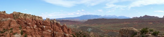
Day 8, Friday - Canyonlands
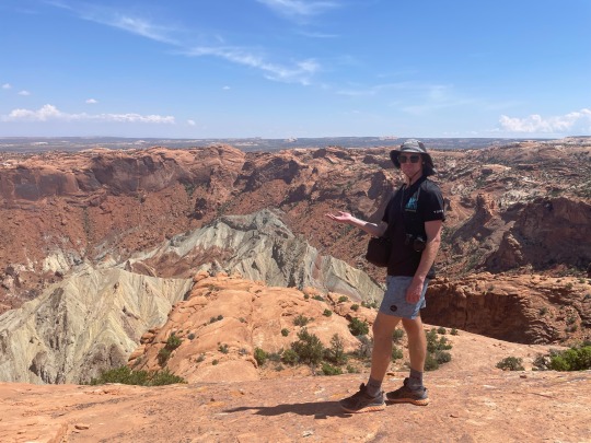
As usual, we started the day by going to the Visitor's Center, this time at Canyonlands. There, they recommended a bunch of shorter walks. First up was, would you believe it, another arch trail - Mesa Arch. This trail gave us an expansive view of the canyon and another quality arch pic.

Next, we did the Upheaval Dome trail which reveals a ~mysterious~ dome shape in the canyon. There are two theories about how it formed - salt and a meteor. Aidan and I are on team meteor.
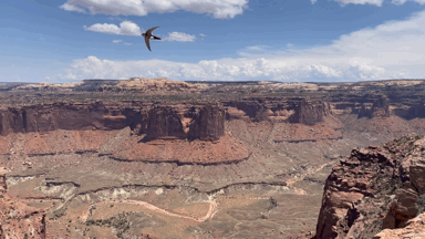
Whale Rock was next, although I don't think we followed the trail. Instead, we walked out as far as we could until we reached the edge of the canyon. There, we saw white throated swifts dive bombing the canyon. The longer we stayed, the closer they got to us. They flew so fast you could hear them soaring through the air. Something about their speed and proximity while sitting on the edge of the canyon was a little unnerving; however, it was such a special and memorable experience.
We had a picnic bench lunch and then went to the Grand View Point Overlook which gave us 360 degree views of the canyon.

We grabbed some quick tacos at the food trucks before heading back to the Lemberos' hotel for a swim - this time, with all the kids. We caught up about our days and hung out until dark. Aidan and I were looking forward to building a fire and making s'mores back at camp but unfortunately it was extremely windy so we had to take shelter in the tent and eat cold s'mores - if you can even call them that. I got a good whole body exfoliation that night from the sand whipping into our tent.

Day 9, Saturday - Arches & Drive to Denver
On Saturday morning Aidan and I went back to Arches to see the Windows. We were supposed to meet the Lemberos' there but we lost service. Aidan and I began the walk and went off to the primitive trail where Chris found us! We got to do the rest of the walk with the whole group and do a few photoshoots. Don't we blend in well with our adopted fam??

Sadly we had to head back to Denver, but at least we had a concert to look forward to on Sunday. Aidan had a great time at his first Red Rocks show! Eventually, we had to say goodbye. Stay tuned for when I go visit Aidan in London - hopefully next year and hopefully with Irene!
2 notes
·
View notes
Text
[ad_1]
Fasten your seat belts as we unveil the best road trip destinations in 2024. Experience sublime scenery, exotic wildlife encounters and diverse cultures on the best road trips in the world.
LAST UPDATE: 22 Dec 2023
Anywhere We Roam is reader-supported. When you buy through links on our site, we may earn a small affiliate commission at no extra cost to you. Thanks for your support - Paul & Mark.
We love a good road trip.
The joy of crossing wide open spaces, with complete freedom. The ability to be where we want when we want, and discover new places on our own timetable.
A well-crafted road trip enables you to catch sunrise or sunset, beat the crowds, and generally pile as many experiences as possible into each precious day.
We’ve put together our favourite road trips to help inspire your next adventure. From winding mountain roads to sun-kissed coastal highways, here are some of the best road trips in the world.
NAMIBIA
Namibia may be the best road trip country in the world. Easy-to-drive gravel tracks crisscross a vast wilderness of remarkable wildlife and natural wonders.
At Sandwich Harbour towering sand dunes drop into crashing oceans. In Sossusvlei, dead black trees are baked into the earth. Fish River Canyon is the second-largest canyon in the world.
Etosha National Park is an exciting and affordable safari park. The Skeleton Coast has vast open horizons, shipwrecks and a huge seal colony.
Namibia has worked hard to conserve its wildlife. Take a road trip there and you’ll learn about their conservation sacrifices and help support their progress.
Read more – 2-week Namibia itinerary.
SOSSUSVLEI
ICELAND
Iceland is a unique destination. Perched on the mid-Atlantic ridge where the Earth’s crust is thin, it’s a volcanic wonderland. Black lava fields drop from towering volcanos, sulphurous vents scar the land and colourful mountains rise above crystal-blue lakes.
There are various road trips in Iceland based on your level of adventure.
Visit geysers, waterfalls, the Fagradalsfjall eruption site, and geothermal pools in the southwest. Alternatively, complete the Ring Road over 10 days where you’ll visit glacial lagoons, whale-watching hot spots, black beaches, and ice caves.
If you’re feeling adventurous, hire a 4×4 and head into the central highlands.
We have more suggestions in our Iceland itinerary guide.
VESTRAHORN, ICELAND
USA CANYONS & RED ROCK
In our opinion, the best road trip in the USA is through the canyons and deserts of Utah and Arizona. Start in Las Vegas before heading across to the Grand Canyon.
Stop off at the mesmerizing mesas of Monument Valley, then continue on to Canyonlands which has some of the best hiking in the country. Just across the highway, Arches National Park has thin arches of rock that somehow defy gravity.
Looping back toward Vegas, pass the white sandstone cliffs of Capitol Reef, and the slot canyons of Escalante, before reaching Bryce National Park.
Finally, head to Zion Canyon to attempt the treacherous Angels’ Landing hike before returning back to Vegas.
CANYONLANDS
ITALIAN DOLOMITES
Is there any better mountain scenery in the world than the Italian Dolomites?
Soaring spires of rock rise above swaying alpine meadows. Turquoise lakes reflect dark forests and jagged peaks.
The whole area is a UNESCO World Heritage site and can easily be explored on a 7-day Dolomites road trip.
Cortina d’Ampezzo is your base for hiking the three towers of Tre Cime di Lavaredo and rowing on the waters of Lago di Braies.
At Val di Funes beautiful churches sit amongst the fields still using traditional farming techniques. While at Val Gardena cable cars rise to the highest alpine meadow in Europe and an other-worldly scene of jagged peaks.
DOLOMITES, ITALY
NC 500
The NC500 loops around the coast of northern Scotland. Approximately 500 miles long, it starts and ends in Inverness. In between, the single-lane track traverses blind summits, 180-degree hairpins, and steep gradients.
The views are staggering with wild craggy mountains on one side and the surging sea on the other. There are castles to explore, white sand beaches, and photogenic highland cattle. Try a tipple from the local distillery and take a journey on the Harry Potter steam train.
The most dramatic section of the entire NC500 loop is in northern Assynt between Kylesku and Lochinver.
NC500, SCOTLAND
ATLAS MOUNTAINS
Morocco is a surprisingly excellent road trip destination.
After starting in Marrakech, follow the old camel train over the Atlas Mountains to find traditional Berber villages nestled into the foothills of spectacular snow-covered mountains. Dropping over the high passes, you’ll encounter deep gorges of red rock, green oasis and medieval walled towns.
Head deeper into the mountains to discover how villages survive with just basic essentials.
The end of the road is the mighty Sahara and an endless sweep of sand dunes.
Driving in Morocco is much easier than you may think. Navigation outside the cities is easy and the roads are always getting better.
After the earthquake in 2023, a Morocco road trip is a great way to support the recovery.
OUNILA VALLEY, ATLAS MOUNTAINS MOROCCO
NORWAY’S FJORDLAND
Norway is renowned for its majestic fjords. These deep, narrow inlets of the sea, flanked by steep cliffs and mountains make a scenic destination for a road trip.
The roads are in excellent condition and there’s a great mix of medieval towns, modern art, and dramatic viewpoints.
Hike to ledges peering over narrow fjords, search for Musk Ox and Arctic Fox on wild plateaus, kayak through narrow fjords or hike across glaciers.
It’s one of our favourite road trip destinations. We completed a 10-day Norway road trip a few years ago and loved it so much we are heading back in 2024.
LYSEFJORD
GREAT OCEAN ROAD
The Great Ocean Road is one of the most awe-inspiring road trips in the world. Meandering along Australia’s southern coast, it showcases charming beach towns, lush rainforests, and dramatic cliffs.
The undisputed highlight is the Twelve Apostles, towering rock formations that rise tall against the backdrop of the Southern Ocean’s surging waves.
But there’s much more to enjoy than just the stunning coastal scenery. Hike to breathtaking waterfalls, spot indigenous wildlife (like koalas and kangaroos), explore the rainforest on an adventure tour, or take surfing lessons on some of Australia’s best waves.
The road trip only takes 3 days. But you could team it with a few nights in Melbourne or head up to Sydney for an excellent city break.
GREAT OCEAN ROAD
ANYWHERE WE ROAM ISREADER-SUPPORTED
Booking your trip via the links on this page earns us a small commission at no extra cost to you.
You can also buy us a coffee.
Big thanks – Paul & Mark.
INSTAGRAM | FACEBOOK
[ad_2]
Source link
0 notes
Text


Moab was the point of this entire trip. Ever since I’d gotten my FJ and explored where to take it off-road, Moab has been on the list. I wanted to go last year but never did. This year I said fuck it and started planning it because why not?
Arches Nat’l Park is so popular now that visitors have to get a timed-entry pass two months beforehand. My ticket was for 3 PM that day. Thankfully the camp host let me get to camp and setup a little early so the park entry time was never going to be an issue. The park entrance is near the the Colorado River which means you get to cross over that multiple times as you go from the town to any of the parks and back. Always very cool to see just how large the river used to be in the canyons around it and knowing it was responsible for the Grand Canyon.
Like Bryce, Arches has an endless number of incredible rock formations that absolutely dwarf you when seen up close. Balancing Rock looks like it could fall at any point. The Petrified Dunes and Fiery Furnace are neat simply because of how incredibly different they both are. The Three Gossips are oddly affecting when viewed. The arches themselves are the real draw to the park. Unfortunately, it was far too hot to really hike to Delicate Arch that day but there’s a viewpoint where it can be seen that gets to the point well enough.
There is another national park and a state park all in the same area around Moab: Canyonlands NP and Dead Horse Point. Canyonlands is absolutely massive and contains a point where the Colorado and Green Rivers converge. Seeing the destructive power of flowing water all around on the landscape is bonkers. You can literally see that these rivers were basically oceans back before humans even existed.
Dead Horse Point has one of the most brutal backstories I’ve ever heard. The park is centered around a mesa which has a narrow entryway. Basically, cowboys herded wild horses onto the point and corralled them in. They took the ones they wanted to break, left, and left the makeshift gate up. The horses had no water and limited food. These cowboys just left these horses to die, and they did. The corpses were discovered sometime later and the name was born of that. The entry to the plateau is now paved but you can see the remnants of the gate on either side of the road. A sad reminder of the destruction white settlers had on the West.
#photography#utah#moab#arches national park#fujifilm#35mm#film is not dead#stay broke shoot film#dead horse point
1 note
·
View note
Text
When I found the orb, I could not believe my eyes. An alien technology I stumbled upon in the Great Salt Flats.
(Story continues on each image)

Immediately I felt as if it made an inter-dimensional connection with my mind…
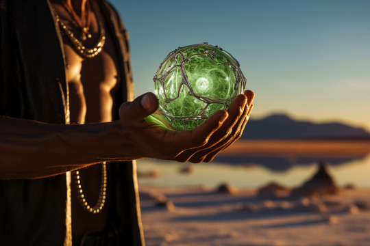
…communicating with me about its power and potential, as its appearance shifted in and out of endless new forms.

I became one with it, as if the owner's operator manual downloaded into my subconscious through some kind of psychic internet.

It was at that moment, I realized it was also a Time Machine. I packed up what I needed to survive in the wilderness for a few months and started on my adventure.

I set my sight on 10th century North America. My first stop was visiting the Miwok Peoples of Yosemite Valley, who had made this beautiful park their home for over 4,000 years before the first European settlers arrived.
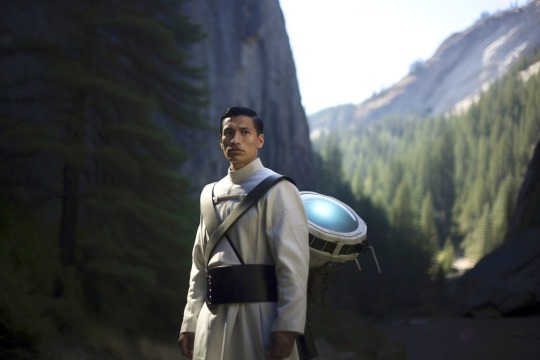
In the first weeks I spent in the past, I discovered vast improvements to my health. The pristine beauty of this untapped and unspoiled wilderness, completely blew my mind. My asthma vanished, and my head began to clear more than I imagined was possible. I felt like a new man, and my thoughts began to put all the pieces together. I finally knew what my mission was.
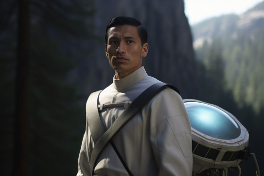
The alien technology gave me the power to replicate a portable solar powered 8K Laser Projector, and portable surround sound system. I already had a collection of my favorite films on a 16TB solid state drive that I always carry with me everywhere in my backpack.
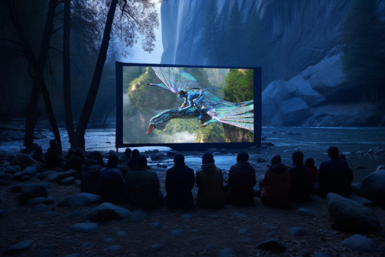
The first films I screened for the Miwok Peoples was Avatar and Avatar 2. These are all the photos I took.

These films completely rocked their world. I did not know their language, and even though all my films were in English, this didn't seem to bother the Miwoks. They were so mesmerized by the music, images, emotions and wonder of this dream technology, the only thing they successfully communicated with me, was that they wanted to watch it again and again all night, until the sunrise at dawn prevented any further viewings.
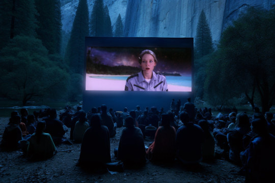
The next night I screened Contact for the Miwoks, which blew their minds even more. They could not take their eyes off the screen for the films entire duration. And when it was finished, they erupted into cries, demanding to see it again.

I had to keep moving on, so I snuck away from the Miwoks and made my way towards Utah, where I visited the Navajo, in an area where Moab would eventually stand. My first night I screened Spider-Man 2. Some of the Navajo were so blown away by the moving images, they approached the screen, thinking they might enter this strange world, the way I entered theirs through my time-machine jump gate.
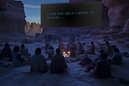
I spent the next week in the Canyonlands and Arches region, screening Star Wars, which attracted some of the largest crowds of Natives yet.

The following week, I screened Gravity for many tribes in the Arches area, with this particular screening near delicate Arch. I wish I could speak the language of these peoples to explain what it was they were seeing, especially the Earth scenes from space. It was during these moments when the tribes broke into the most excited chatter. Perhaps they intuitively already knew what it was they were looking at.

As I made my way further East, I started screening Pixar movies. This was the Inside Out showing I put on for the tribes near Mesa Verde, which was their all time favorite.
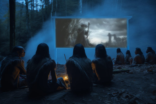
As I passed the great divide and made my way into the Ozarks, I visited the Osage tribe of Oklahoma, screening for them; BFG. Their favorite moment was the dream hunt sequence through the lake dimensional portal.

Into Arkansas, I screened Black Panther which was a favorite among many tribes. They were completely mesmerized by the battle sequences. The elders seemed to understand the concept behind T'Challa's Dream World sequence after eating the sacred Vibranium herb.
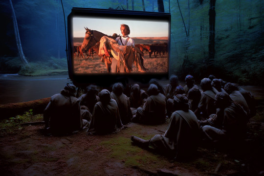
The Tioux Tribe fell in love with Dances with Wolves when I screened it. It seemed many of the natives among them, even understood some of the language spoken by the Comanche in the movie.
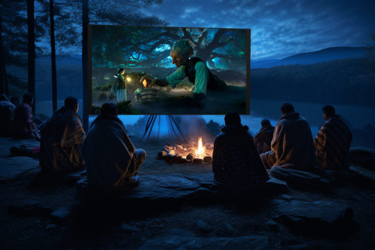
Next I screened the Hobbit and Lord of the Rings trilogies for the Cherokee of the Great Smoky Mountains, who absolutely fell in love with Tolkien’s world.

Further North I screened the Star Wars sequels.

One of the all time best receptions to my films came when I screened the Greatest Showman for the Susquehannock of Pennsylvania. They loved the music so much, they could be heard singing it hours later and even into the next morning.
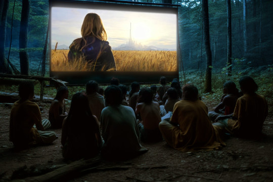
In New England, I screened Tomorrowland for the Onondaga, who loved the pin scenes the most, where Casey Newton was transported to the future utopian city.

When I took the Time Machine back home to 2023, I found myself in a real life Tomorrowland. My objectives were complete. My intent from the very beginning, was to save humanity from the climate crisis and World War 3. I returned to an Earth light years ahead of what I'd left behind. Humanity was united into a United States of Earth, and I discovered a science renaissance had swept North America starting in the 12th Century after I'd left.

I knew from the beginning of my mission, that screening films across North America would have the same effect we saw in Arthur C Clarke's masterpiece; 2001, with the monoliths serving to facilitate a quantum leap in consciousness for humankind. Feeding back future films to ancient peoples, had a similar impact, creating mutations in their consciousness that drove them to seek a world as wondrous as what they witnessed on the big screen. When Europeans arrived, they were not defeated, because their technology was superior to anything coming at them from Columbus. And just as I suspected, the technology of Native Americans relied more on biomimicry and alternative energy. They completely left the fossil fuels in the ground.
“Why” you ask, didn’t humanity’s films have the same impact on present day civilization? It’s because the skyrocketing CO2 in the atmosphere created a dumbing down effect for all humankind, where new pandemics were erupting just as IQ’s were plummeting, and humans were incapable of saving themselves from their predicament. Think of the analogy of a frog sitting in a slowly heating pot, the gradual heat doesn’t let them see that anything is wrong, until it’s too late, right before the boil. The sphere revealed to me that the climate and CO2 crisis in the atmosphere was having the same disastrous effect on humankind. That’s why aliens chose me, because their non interference prime directive prevented them from saving us themselves. But if they could get their technology into the hands of a trusted human, to travel back in time and recover from CO2 sickness, they might be able to change the timeline enough to save the world.
#avatar#avatar2#james cameron#jamescameron#pandora#navi#thewayofthewater#worldspirit#NativeAmericans#NativeAmerica
0 notes
Text
Southwest vacation

Visiting the American Southwest over the weekend is invigorating. The most popular shooting locations on Earth can be located here. Including the national parks of the Grand Canyon, Monument Valley, Mesa Verde, Zion, and Arches. There are desert areas, lakes, canyons, caverns, and guest farms. Additionally, it is well-known for amazing cities like Sedona, Tucson, Taos, and Santa Fe. Consequently, these are the top Southwest vacations.
0 notes
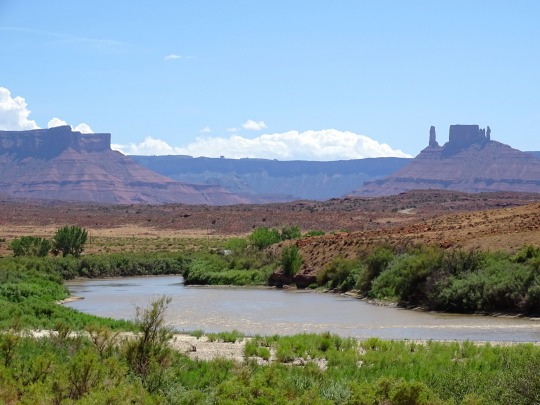
Photo
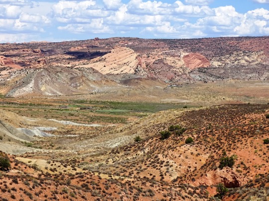

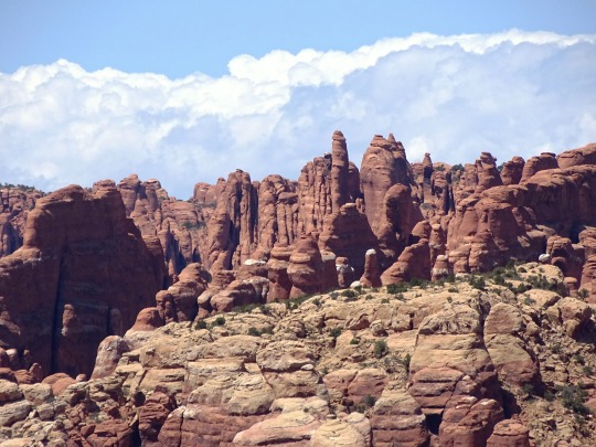
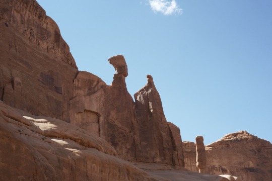
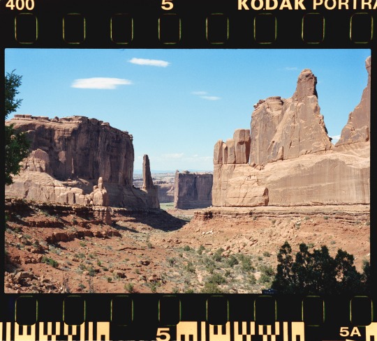
Fiery Furnace, Arches National Park (No. 5)
People have come to the area that is now Arches National Park for thousands of years. The earliest visitors weren't just sight-seeing, though. Hunter-gatherers migrated into the area about 10,000 years ago at the end of an Ice Age. As they explored Courthouse Wash and the Salt Valley area, they found pockets of chert and chalcedony: two forms of microcrystalline quartz perfect for making stone tools. Chipping or knapping these rocks into dart points, knives, and scrapers, they created debris piles that are still visible to the trained eye.
Then, roughly two thousand years ago, the nomadic hunters and gatherers began cultivating certain plants and settled the Four Corners region. These early agriculturalists, known as ancestral Puebloans, raised domesticated maize, beans, and squash, and lived in villages like those preserved at Mesa Verde National Park. Evidence shows that farming climaxed between 500 CE and 1300 CE. A change in climate that made farming more difficult may have been a driving factor in a decline in farming.
Source
#Fiery Furnace Overlook#Arches National Park#landscape#countryside#USA#Grand County#red rock#rock formation#blue sky#clouds#flora#nature#geology#grass#bush#original photography#Colorado Plateau#travel#vacation#desert#Utah#Western USA#tourist attraction#landmark#valley#summer 2022
34 notes
·
View notes
Video
youtube
BELVÉDÈRES SUR LES ROUTES UT-24, UT-119 & I-70 EN UTAH
Je vous présente quelques endroits où nous nous sommes arrêtés en cours de route lorsque nous avons quitté Capitol Reef pour nous diriger vers Arches National Park.
Koosharem Reservoir - State Route 24
Coordonnées GPS: 38.60069, -111.84141
Le réservoir de Koosharem est un petit lac peu profond formé par le barrage d'otter Creek au-dessus de Grass Valley. Il est situé sur la State Route 24 près de Venice en Utah.
Nous avons décidé de faire une petite pause à cet endroit et de profiter du joli point de vue sur le lac derrière lequel se trouvent des montagnes aux sommets enneigés.
Les installations du réservoir sont limitées à une utilisation diurne uniquement, mais des toilettes, des tables de pique-nique et un barbecue sont disponibles.
C'est un également excellent site pour la pêche à la truite.
Rainbow Hills - Glenwood
Coordonnées GPS: 38.77823, -111.94188
Peu avant d'arriver à Glenwood, un belvédère sur la State Route 119, nous permet de bénéficier de points de vue spectaculaires sur Rainbow Hills, une série de collines multicolores situées sur le côté Est de la vallée de Sevier.
I-70 Ouest - Secteur de San Rafel Swell
À l'ouest de Green River, l'Interstate 70 pénètre dans le San Rafael Swell qui abrite des mesas, des buttes, des dunes de sable pétrifiées et de canyons, dont une grande partie est sculptée dans du grès Navajo et parsemée de genévrier et de sauge.
À part l'autoroute, très peu de routes accèdent à la région éloignée et celles qui le font sont en terre.
On retrouve plusieurs aires de repos érigées de chaque côté de cette autoroute pour nous permettre de nous reposer de profiter de vues incroyables sur cette région.
En ce qui nous concerne, nous avons circulé en direction ouest sur cette autoroute. Vous trouverez donc ci-dessous l'emplacement de ces aires de repos.
Sand Bench View Area
Coordonnées GPS: 38.82921, -111.11521
Devil's Canyon View Area
Coordonnées GPS: 38.84911, -110.92570
Ghost Rock View Area
Coordonnées GPS: 38.86154, -110.81161
Spotted Wolf Canyon View Area
Coordonnées GPS: 38.93250, -110.47219 Stationnement
Coordonnées GPS: 38.93089, -110.46924 Point de vue +/- 484 m aller
I-70 Est - Secteur de San Rafel Swell
San Rafael Reef View Area
Coordonnées GPS: 38.92124, -110.43091 Monter sur la petite colline à droite du stationnement
Nous nous sommes rendus également à cette aire de repos située du côté opposé de l'autoroute. La vue est grandiose. Cependant, nous avons dû faire un long détour ensuite pour revenir en direction ouest car les traverses sont rares sur cette autoroute.
***************
AUTRES VIDÉOS DE CE ROAD TRIP:
https://www.youtube.com/playlist?list=PLlRroQCNvchsdvRQOTUATm7OU6BabhYIF
ABONNEZ-VOUS ► https://www.youtube.com/c/SouthAngelVideo?sub_confirmation=1
SUIVEZ NOUS :
• BLOGGER ► http://southangelvideo.blogspot.ca/
• INSTAGRAM ► https://www.instagram.com/annestrasbourg/
• FLICKR ► http://www.flickr.com/photos/anne_strasbourg/collections/
• TWITTER ► https://twitter.com/AnneStrasbourg
1 note
·
View note
Text
Tough bird wyv hiide

Tough bird wyv hiide free#
Slowly, this decorating habit started to make sense: It was a signal by the strongest birds that they were tough and could protect their nests. So a research team set up in a national park in Spain and recorded and videoed kites in 127 nests for five years. It's not just any kind of plastic that works, though - it's only white plastic bits and pieces the birds scavenge and lay inside their nests alongside their eggs.īiologists wondered for years why these big predatory birds do this. The raptors decorate their nests with plastic - apparently to scare other birds off. Since the 1980s, researchers have been tagging birds in a population to track them through their life spans.īut scientists in Spain have discovered a very different kind of signaling by birds called black kites. Two can be found in the water below the bridge at Jade Gate Waypoint.An eight-year-old black kite watches an intruding individual from its perch. Head west from Faun's Waypoint to the small entrance once inside head westĪt Juno Hatchery after successful completion of the Lead newly hatched turtles to the safety of the hatchery ponds (80), or Defeat the Void attacking Juno Hatchery (80) dynamic events. You must acquire at least 30 Hall of Monuments reward points South of the camp, only if camp is tier 2-3 On mesa to the north directly above Joko's Domain Waypoint. South of Nemus Grove Waypoint, by the vista South of Torstvedt Homestead Waypoint on the ledge before the bridge On the Research Waypoint side of the bridge You must acquire at least 15 Hall of Monuments reward points Northwest portion of the Glowering Overlook area, in SW of map You must acquire at least 20 Hall of Monuments reward points Southeast of Old Lion's Arch, around the southern point of the U-shaped wreckageĮnd of Dawnside Quay pier at Rata Sum Port Authority (Available without completing meta)īy Krait's Larder west of Overlake Haven Waypoint On a ledge on the south side of Snow Leopard Lodge
Tough bird wyv hiide free#
On the dirt path east of Seeker's Village northeast of the Free City of AmnoonĮast of Havfrue Basin Waypoint just before the road In the canyon running North/South to the west of Scholar Issa Farone The entrance is on the surface (above the cave network), you can find the Cheetah after following the tunnel east and then south Beware of Reef Drake Broodmother, who likes to hang out in front of the caveĪlong the river north of Cereboth Waypoint and west of Gort's Pitīy the river, southeast of Sentinel Scout Liharn In the heart region for Braxa ScalehunterĪlong the eastern side of the river near the bridgeĬave under western tip, access from the beach across from Crab Toss Island. Inside Minister Wi's Mansion or in Western Commons in the square area north of the word "Commons" West of Ogre Road Waypoint, at the point of the first heart you encounter Go inside, then up stairs on right and head outside You must acquire at least 25 Hall of Monuments reward points In the field south of Talajian Waypoint about halfway to First Haven WaypointĮast of Brilitine Waypoint in Skrittsatawney, head around the north side to enter In the cave east of Vendrake's Homestead Waypoint There is a small group of them swimming above the Wreckage of the Breachmaker The following is an abbreviated list of pet locations, designed for those wishing to charm each pet as fast as possible.
0 notes
Text
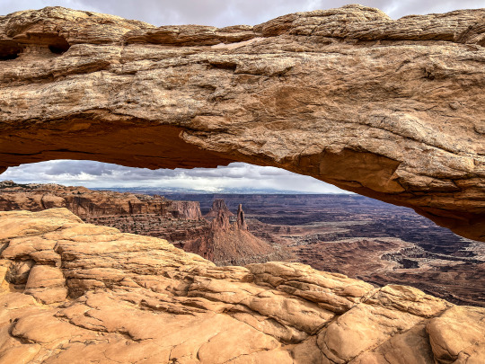
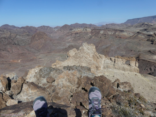
Mesa Arch
There was only one trailhead parking lot area that had an abundance of cars (relatively speaking) in the Island in the Sky district. The trail leading one to Mesa Arch. I bundle up and head on out to see why….
The hike was short, not even 1/4 mile long, so soon I was at the precipice with the great arch before me. The drop off into the canyon below had me dizzy and with the wind blowing, my…
View On WordPress
#a day in the life#Canyonlands#hiking#Island in the Sky#Mesa Arch#outdoor adventures#road trip#solotravel#Southern Utah
0 notes
Text
UTAH TRAVEL GUIDE
Utah is one of our favorite states in the USA for outstanding natural beauty, fun adventures, and unique national parks.
We have spent about six weeks exploring this beautiful state - mostly Southern Utah and plan to return again and again!
Keep scrolling for our posts on best things to see and do, hidden secrets and amazing hikes.
UTAH HIGHLIGHTS
From hidden secrets to popular national parks, here are your top things to do in Utah.
UTAH ITINERARY GUIDES
Our favorite region for exploring national parks in the American Southwest. Think vast canyons, stunning vistas, giant arches and mesas, Native American culture, and the spectacular Colorado River helping to shape the land.
This colorful, rocky, desert landscape is perfect for adventurous activities and camping under starry skies.
The following itinerary guides for Southwest USA include Utah destinations and many national parks and monuments, including Monument Valley Navajo Tribal Park, which is owned and managed by the Navajo people and is unmissable.
UTAH NATIONAL PARKS
If you love rugged beauty, you are in the right place in Utah.
To full embrace that you’ll want to experience each of Utah’s five national parks, knowns as the Mighty 5.
These Utah national parks have some of the most stunning landscapes, thrilling hikes, and fun outdoor adventures.
The national parks are close enough to visit each one on a road trip. This area of Southern Utah is one of our favorites in the country.
Plus, there are several other federally protected areas nearby that are just as beautiful!
These Utah national parks are popular so plan your trip there carefully to avoid crazy crowds.
We offer lots of tips in the following posts.
P.S. One of our favorites is Capitol Reef National Park and is often overlooked by most visitors!
Capitol Reef National Park Canyonlands National Park Arches National Park Zion National Park Bryce Canyon National Park (we have not returned since pre-blogging days. We mention some highlights in this post. )
UTAH HIDDEN SECRETS
Of course you want to visit all five national parks in Utah. They are worthy of your time.
But, don’t overlook Utah’s lessor known state parks and national monuments. They are equally beautiful and offer many outdoor adventures and surprises.
They are also less crowded than the national parks so could offer a much better experience in that way.
13 Places in Utah no one tells you about Stunning Adventures in Grand Staircase-Escalante National Monument The Valley of Gods and Natural Bridges Monument The Magical Goblin Valley State Park Thrilling ATV adventure in Sand Hollow State Park 15 Amazing things to do in Monument Valley 16 Adventurous things to do in Moab Camping at Lone Rock Beach
UTAH HIKES NOT TO MISS
With its desert landscapes, canyons, mesas, buttes and slot canyons, Utah is filled with hiking experiences you’ll never forget.
You’ll find many in each of our national and state parks above.
Here are a couple more that we won’t forget.
Lower Creek Calf Falls, Escalante Peek-a-Boo and Spooky Slot Canyons, Escalante The Red Reef Trail, St George 5 Snow Canyon Hikes Hiking the Zion Narrows with Kids

0 notes
Text


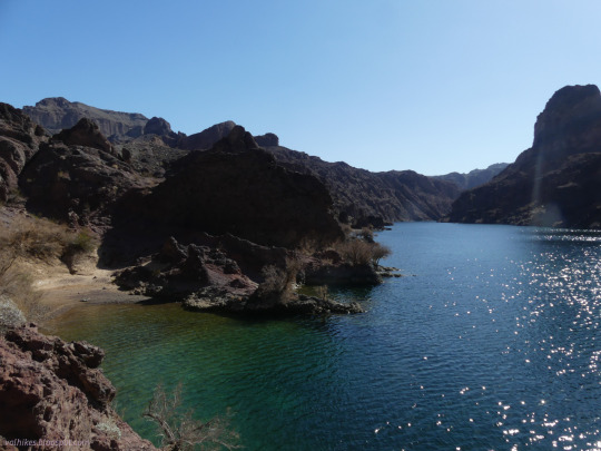
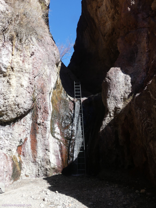
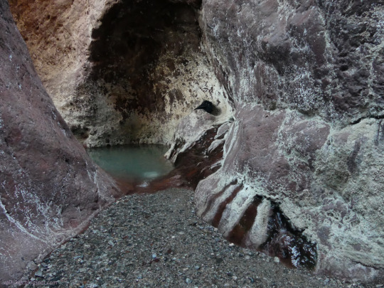
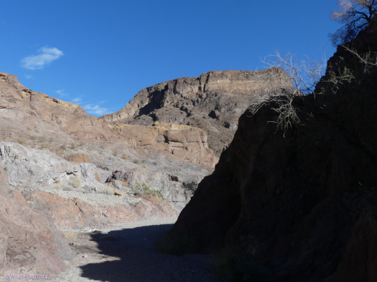
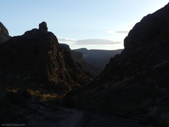
Lake Mead National Recreation Area, Arizona.
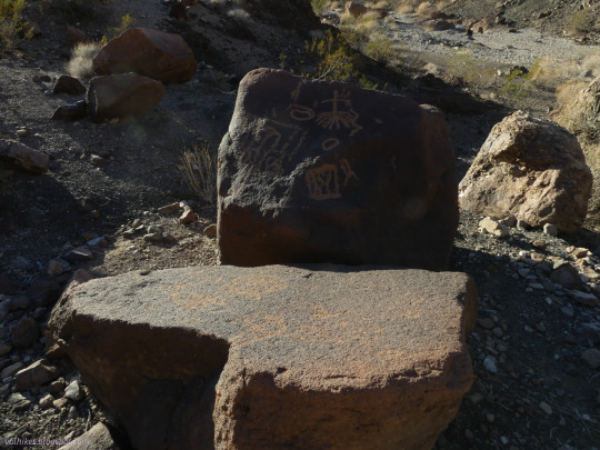
I decided to go ahead and visit one of those surely crowded things: a hot spring. (Specifically Arizona Hot Spring, sometimes known as Ringbolt.) On the way, I had to stop by Liberty Bell Arch and the grand overlook of the Colorado River. Lots of amazing canyon along the washes. There was scrambling on braided paths looking for the one actually passable to normal humans between the washes. A detour to see some petroglyphs. It was quite a full day even without the long soak in the hot waters.
#day hike#hiking#landscape#mountains#mesas#hike#Arizona#Arizona Hot Spring#travel#loop hike#outside#Lake Mead National Recreation Area#nature#natural arch#Liberty Bell Arch#desert#wash#Colorado River
11 notes
·
View notes
Last Seen Blogs

scalesystem
DØPESCALE

ofdragonsandgods
OF DRAGONS AND GODS.

reylo-mind-trick
you're not alone.

the-millennial-tree
The Tree

livesymplistic
But is it Art?