#South Ronaldsay a
Text
Fancy dress parade in South Ronaldsay, Orkney Library & Archive
https://orkneylibrary.org.uk/
6 notes
·
View notes
Video

flickr
Morning light from Hoxa Head; South Ronaldsay by Tony
#East Mainland#GBR#Newbigging#Orkney#Scotland#United Kingdom#britain#coast#dawn#europe#geo:lat=58.82085329#geo:lon=-3.02254196#geotagged#house#hoxa#island#morning#rinibar#sky#south ronaldsay#sunrise#©2021 Tony Sherratt#South Ronaldsay a#2021 09 20 064014
11 notes
·
View notes
Photo
Scotland Fix of the Day: The coasts of Scotland are spectacular but treacherous. The towering cliffs and submerged reefs were wrecking ships and killing sailors for centuries before the Northern Lighthouse Board started building the lighthouses that we here today just expect to grace scenes of nautical splendor like Noup Head (built 1898) on Westray in Orkney. Amazingly one family – the Stevensons – was responsible for the design and building of 82 of the most spectacular lighthouses. Right now I'm reading their story in the excellent book, The Lighthouse Stevensons by Bella Bathurst. The scion of the family was Robert Stevenson, who in 1789 as a young engineer, assisted his father-in-law in building the Dennis Head Old Beacon on North Ronaldsay in Orkney. It was classically beautiful but a poor aid to stormswept sea captains. But in the succeeding decades his innovations set the standard for lighthouse design and construction, not just in Scotland but around the world. Over the years I have (like many travelers) been drawn to these fantastic structures built at such cost to in remote locations. Neist Point on the Isle of Skye is one, built in 1909 by David Alan Stevenson (Robert's grandson), features perhaps the most spectacular setting of any. Another, at the Butt of Lewis (built 1860s by David Stevenson, Robert's son) guards hazardous cliffs. And Cape Wrath, seen form my cabin porthole as we rounded Scotland's northern headlands, refers not to vengeful terrain but the Norse word for a "turning point", one that would take them home. (Robert 1828.) Fair Isle South (1892 by David and Charles) was bombed in WWII. Altogether I find the Stevenson's story both compelling and daunting, like a myth from a lost world. Like a place you might find in a tale by Robert Louis Stevenson who shunned the family business to write books. #scotland #heather #highlands #bestofscotland #hiddenscotland #thehighlandcollective #scotland_highlights #ig_scotland #visitscotland #scotlandgreatshots #scottishhighlands #scotland_greatshots #igersscotland #unlimitedscotland #scotlandtrip #scotlandtravel #thescottishcollective #simplyscotland #moodyscotland #scotlanddreams #orkney — view on Instagram https://ift.tt/tbBcf5G
86 notes
·
View notes
Text
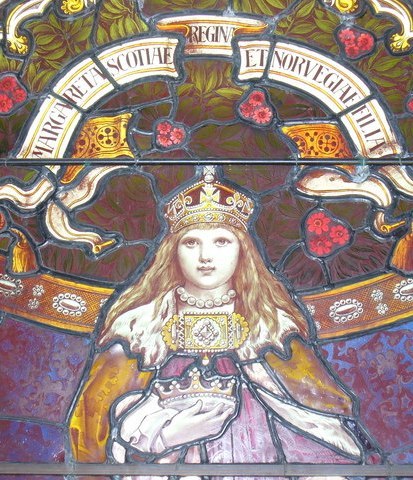
April 9th 1283 saw the birth of Margaret, Maid of Norway.
Margaret was called Queen but was never crowned. She was known as Lady of Scotland, Margaret of Scotland and the Maid of Norway. The story of her life is very poignant and short. She is widely considered to have been Queen of Scots from 1286 until her death in 1290, although this is disputed.
Margaret’s claim to the Scottish throne came from her grandfather, Alexander III. Alexander had come to the throne at the age of 8 and had proved to be a very capable and strong monarch. It was his death at Kinghorn in March 1286 that set the chain of events in motion that led to Margaret being Queen and ultimately The Wars of Scottish Independence.
Alexander's death, en route to be with his new young bride Yolande de Dreux, threw Scotland into chaos. Robert Bruce (grandfather of Robert I) and John Balliol both made claims for the throne, and to add to the confusion, Alexander III's widow Yolande said she was pregnant. When her child miscarried or was stillborn, the Scottish Parliament appointed six guardians to look after Margaret.
The Scottish nobility called on assistance from Edward I of England in an effort to secure Margaret's position. Edward arranged the Treaty of Birgham in July 1290. Under its terms Margaret, Maid of Norway was betrothed to his son Edward (later Edward II of England). In return Edward I guaranteed Scottish independence and agreed to act as ward for the young Queen Margaret.
In September 1290, Margaret set sail in a Norwegian ship from Bergen bound for Leith and accompanied by Bishop Narve of Bergen. Storms drove the ship off course to Orkney, and it eventually landed at what is now, St Margaret's Hope, South Ronaldsay. Here Margaret, Maid of Norway, died, apparently from the effects of sea-sickness, still aged only eight. Had her marriage to Edward gone ahead, the crowns of Scotland and England would have been united some three hundred years earlier than they eventually were, in 1603. And three hundred years of bloody history would probably have been very different.
As it was, Margaret's body was returned to Bergen and buried beside her mother, in the north side of the choir, in Christ's Kirk at Bergen. Before her burial, her father King Eirik confirmed the identity of her body. This is significant because in 1300, a year after the death of King Eirik, a woman turned up in Bergen claiming to be Margaret. There was much popular support for her claim, despite the identification of Margaret's body, and despite the fact that the woman appeared to be about 40 when Margaret would only be 17. The false Margaret was executed in 1301.
The death of the Maid of Norway in 1290 brought to an end the rule of the House of Dunkeld or the House of Canmore, which had started with the accession to the throne of Malcolm III in 1058. It also paved the way for two years of chaos, with 13 claimants for the Scottish throne having their claims assessed by Edward I of England. The Wars of Independence from England were just around the corner......
29 notes
·
View notes
Text


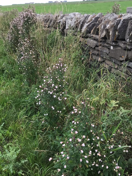
Plant of the Day
Monday 5 September 2022
In the roadside ditches of South Ronaldsay, Orkney, a pale form of the wildflower Epilobium hirsutum (great willowherb) is flowering. This plant is found in damp places, such as wet grasslands, ditches and riversides spreading by fluffy white seeds and rhizomes.
Jill Raggett
#Epilobium#greatwillowherb#wildflower#roadside#ditches#pinkflowers#dampgarden#plants#writtledesign#horticulture#orkney#scotland
103 notes
·
View notes
Note
If you had asked me to guess what you could do at something called “The Tomb of the Eagles”, I would not have guessed skateboarding and ice cream lol
It's not actually a skateboard, but a broader board with rolls on it and you lie down on it on your back and then you grab a rope above you and use to drag yourself into the tomb and there you can get off the board and look around and it's really cool!
As for the icecream - the museum/shop doesn't have a café but they do have a coffee machine, I believe, and they definitely have a little freezer with little tubs of ice cream made with milk from Scottish cows and there's a little bench in front of the shed/garage/whatever at the very beginning of the walk to the tomb where you are a bit sheltered from the wind and can sit in the sun, if the timing is right, and eat the ice cream and it's just such a great start to a visit of the Orkneys.
So if you visit the Orkneys, especially if you take a car across, turn right after the ferry towards the tip of South Ronaldsay and visit the Tomb of the Eagles!!! I can really highly recommend it!
Oh, and ice cream wise, I recommend honeycomb or salted caramel, though really all flavours I've tried so far were delicious!
#lessa says#asks#I will always be ready to harp on about how great Scotland is#though really the Orkneys are extra special#so much amazing history there#I really really recommend visiting if you can
1 note
·
View note
Text
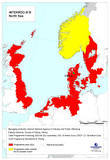
About North Sea, facts and maps
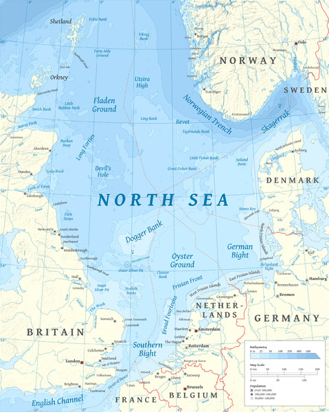
The North Sea (historically also known as the German Ocean) is a part of the Atlantic Ocean, located between Norway and Denmark in the east, Scotland and England in the west, and Germany, the Netherlands, Belgium and France in the south. The North Sea is one of the world's most important fishing grounds. The sea is also rich in oil and gas. Anthropogenic impacts have been significant for many years.
The North Sea is a body of water surrounded by the following countries: Norway – Vestlandet. Denmark – separating it from the Baltic Sea. Germany – the states of Schleswig-Holstein and Lower Saxony, with ports at Bremerhaven and Hamburg.
The North Sea lies between Great Britain, Norway, Denmark, Germany, the Netherlands, Belgium and France. An epeiric sea on the European continental shelf, it connects to the Atlantic Ocean through the English Channel in the south and the Norwegian Sea in the north. It is more than 970 kilometres (600 mi) long and 580 kilometres (360 mi) wide, covering 570,000 square kilometres (220,000 sq mi).
It hosts key north European shipping lanes and is a major fishery. The coast is a popular destination for recreation and tourism in bordering countries, and a rich source of energy resources, including wind and wave power.
The North Sea has featured prominently in geopolitical and military affairs, particularly in Northern Europe, from the Middle Ages to the modern era. It was also important globally through the power northern Europeans projected worldwide during much of the Middle Ages and into the modern era. The North Sea was the centre of the Vikings' rise. The Hanseatic League, the Dutch Republic, and the British each sought to gain command of the North Sea and access to the world's markets and resources. As Germany's only outlet to the ocean, the North Sea was strategically important through both World Wars.
The coast has diverse geology and geography. In the north, deep fjords and sheer cliffs mark much of its Norwegian and Scottish coastlines respectively, whereas in the south, the coast consists mainly of sandy beaches, estuaries of long rivers and wide mudflats. Due to the dense population, heavy industrialisation, and intense use of the sea and the area surrounding it, there have been various environmental issues affecting the sea's ecosystems. Adverse environmental issues – commonly including overfishing, industrial and agricultural runoff, dredging, and dumping, among others – have led to several efforts to prevent degradation and to safeguard the long-term economic benefits.
The International Hydrographic Organization defines the limits of the North Sea as follows:
On the Southwest. A line joining the Walde Lighthouse (France, 1°55'E) and Leathercoat Point (England, 51°10'N).
On the Northwest. From Dunnet Head (3°22'W) in Scotland to Tor Ness (58°47'N) in the Island of Hoy, thence through this island to the Kame of Hoy (58°55'N) on to Breck Ness on Mainland (58°58'N) through this island to Costa Head (3°14'W) and Inga Ness (59'17'N) in Westray through Westray, to Bow Head, across to Mull Head (North point of Papa Westray) and on to Seal Skerry (North point of North Ronaldsay) and thence to Horse Island (South point of the Shetland Islands).
On the North. From the North point (Fethaland Point) of the Mainland of the Shetland Islands, across to Graveland Ness (60°39'N) in the Island of Yell, through Yell to Gloup Ness (1°04'W) and across to Spoo Ness (60°45'N) in Unst island, through Unst to Herma Ness (60°51'N), on to the SW point of the Rumblings and to Muckle Flugga (60°51′N 0°53′W) all these being included in the North Sea area; thence up the meridian of 0°53' West to the parallel of 61°00' North and eastward along this parallel to the coast of Norway, the whole of Viking Bank is thus included in the North Sea.
On the East. The Western limit of the Skagerrak .
Why is North Sea so rough?
Because the North Sea is shallow, with an average depth of less than 328 feet, its waters can get choppy -- a result of tidal patterns and storms. While all this churning brings up nutrients to the surface that help its marine life thrive, it's not ideal for cruising outside of the summer months.
Which countries own the North Sea?
While most reserves lie beneath waters belonging to the United Kingdom and Norway, some fields belong to Denmark, the Netherlands, and Germany. Most oil companies have investments in the North Sea.
Can you swim in North Sea?
For example, the North Sea in the UK, which is on our doorstep, has very low sea temperatures, but that doesn't stop people from swimming in it. In fact, on the northeast coast of England, there are many beaches where you can swim in the icy water year-round!
Who owns oil in the North Sea?
The Norwegian and British sectors hold most of the large oil reserves. It is estimated that the Norwegian sector alone contains 54% of the sea's oil reserves and 45% of its gas reserves.
What is a North Sea danger?
The North Sea is one of the most dangerous seas in the world. It has wild storms and foggy winters. Because the sea is mostly shallow, the currents are strong and often pull in different directions. Even though the North Sea can be dangerous, it is important to trade.
Is North Sea a land?
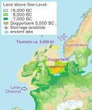
Doggerland is a submerged land mass beneath what is now the North Sea, that once connected Britain to continental Europe. Named after the Dogger Bank, which in turn was named after the 17th-century Dutch fishing boats called doggers.
How warm is the water in the North Sea?
Unsurprisingly the sea is colder in the northern extremes of the sea where temperatures reach an average low of around 6 °C (43 °F). The warmest summer temperatures are seen to the south and can regularly reach 18 °C (64 °F) in August.
Is the North Sea very cold?

The waters of the North Sea are cold, ranging between 14 and 20 degrees C in the summer months. If you come from a country where the sea water temperature is above 22 degrees C all summer, and up to 26 degrees, it will be hard for you to swim in the chilly water of the North Sea.
How deep is the North Sea?
700 m
How much oil is left in North Sea?
"The waters off the coast of the UK still contain oil and gas reserves equivalent to 15 billion barrels of oil equivalent (boe), enough to fuel the UK for 30 years, but more investment in exploration is needed to slow down the decline in domestic production to safeguard the nation's energy security.

Does the North Sea have fish?

Today mainly mackerel, Atlantic cod, whiting, coalfish, European plaice, and sole are caught. In addition, common shrimp, lobster, and crab, along with a variety of shellfish are harvested.
Why is North Sea water brown?
When the water looks murky or brown, it means there is a lot of mud, or sediment, in the water. Sediment particles can be so tiny that they take a long time to settle to the bottom, so they travel wherever the water goes. Rivers carry sediment into the bay, and waves and tides help keep the sediment suspended.
Why do we sell North Sea oil?
Currently 80% of North Sea oil is exported because there is little demand from the country's refineries for UK crude oil. But even gas – where there is domestic demand – is sold overseas.
Does China own North Sea oil? Chinese investments in the North Sea
China National Offshore Oil Corporation, or CNOOC, has stakes in multiple North Sea oil fields including one of the UK's highest producers Buzzard. CNOOC has further stakes in Golden Eagle, and the combined platform which oversees the Scott, Telford and Rochelle fields.
Why is North Sea oil so important?
Over its lifetime, the North Sea has contributed approximately NOK 16.5 trillion ($1.82 trillion at the time of writing) in today's NOK to the economy. In 2021 alone, it made up 20% of GDP, 20% of government revenues, 20% of investments, and 50% of total exports.
What lives at the bottom of the North Sea?

Worms, crustaceans and shellfish live in holes and tunnels under the surface of the sea floor. If you look closely, you can identify quite a lot of life on the bottom: crabs and sea snails, such as laver spire shells and periwinkles, crawl around. Lots of other animals are attached to stones or ship wrecks.
Is the North Sea very polluted?
New research led by Cambridge earth scientists has documented heavy metal pollution along the North Sea coast over the last century. The study, published in the Marine Pollution Bulletin, used dog whelks collected from the Belgian and Dutch foreshores as a tool to identify changes in lead pollution over time.
What is the North Sea also called?
The North Sea (historically also known as the German Ocean) is a part of the Atlantic Ocean, located between Norway and Denmark in the east, Scotland and England in the west, and Germany, the Netherlands, Belgium and France in the south.
Is Atlantis in the North Sea?
While Plato's story explicitly locates Atlantis in the Atlantic Ocean near the Pillars of Hercules, location hypotheses include Helike, Thera, Troy, and the North Pole.
Is the North Sea salt water?
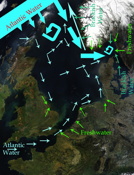
The salinity averages between 34 and 35 grams per litre (129 and 132 g/US gal) of water. The salinity has the highest variability where there is fresh water inflow, such as at the Rhine and Elbe estuaries, the Baltic Sea exit and along the coast of Norway.
Is the North Sea nice?

Seemingly endless beaches, chugging ships passing by, warm sand between your toes: The view of the North Sea landscape is impressive. So it's not surprising that many vacationers struggle to decide where to go on the North Sea. All the beaches have a unique charm there, yet some stand out in particular.
The North Sea is bounded by the Orkney Islands and east coast of Great Britain to the west and the northern and central European mainland to the east and south, including Norway, Denmark, Germany, the Netherlands, Belgium, and France. In the southwest, beyond the Straits of Dover, the North Sea becomes the English Channel connecting to the Atlantic Ocean. In the east, it connects to the Baltic Sea via the Skagerrak and Kattegat, narrow straits that separate Denmark from Norway and Sweden respectively. In the north it is bordered by the Shetland Islands, and connects with the Norwegian Sea, which is a marginal sea in the Arctic Ocean.
The North Sea is more than 970 kilometres (600 mi) long and 580 kilometres (360 mi) wide, with an area of 750,000 square kilometres (290,000 sq mi) and a volume of 54,000 cubic kilometres (13,000 cu mi). Around the edges of the North Sea are sizeable islands and archipelagos, including Shetland, Orkney, and the Frisian Islands. The North Sea receives freshwater from a number of European continental watersheds, as well as the British Isles. A large part of the European drainage basin empties into the North Sea, including water from the Baltic Sea. The largest and most important rivers flowing into the North Sea are the Elbe and the Rhine – Meuse. Around 185 million people live in the catchment area of the rivers discharging into the North Sea encompassing some highly industrialized areas.
Major features
For the most part, the sea lies on the European continental shelf with a mean depth of 90 metres (300 ft). The only exception is the Norwegian trench, which extends parallel to the Norwegian shoreline from Oslo to an area north of Bergen. It is between 20 and 30 kilometres (12 and 19 mi) wide and has a maximum depth of 725 metres (2,379 ft).
The Dogger Bank, a vast moraine, or accumulation of unconsolidated glacial debris, rises to a mere 15 to 30 m (50 to 100 ft) below the surface. This feature has produced the finest fishing location of the North Sea. The Long Forties and the Broad Fourteens are large areas with roughly uniform depth in fathoms (forty fathoms and fourteen fathoms or 73 and 26 m or 240 and 85 ft deep, respectively). These great banks and others make the North Sea particularly hazardous to navigate, which has been alleviated by the implementation of satellite navigation systems. The Devil's Hole lies 320 kilometres (200 mi) east of Dundee, Scotland. The feature is a series of asymmetrical trenches between 20 and 30 kilometres (12 and 19 mi) long, one and two kilometres (0.6 and 1.2 mi) wide and up to 230 metres (750 ft) deep.
Other areas which are less deep are Cleaver Bank, Fisher Bank and Noordhinder Bank.
Read the full article
#AretherewhalesintheNorthSea?#CanyouswiminNorthSea?#CanyouswimintheNorthSea?#DoesChinaownNorthSeaoil?#DoesitsnowintheNorthSea?#DoestheNorthSeagettsunamis?#DoestheNorthSeahavefish?#HowbigistheNorthSea?#HowdeepistheNorthSea?#HowmuchoilisleftinNorthSea?#Howmuchoilisleftintheworld?#HowwarmisthewaterintheNorthSea?#IsAtlantisintheNorthSea?#IsitNorthSea?#IsNorthSeaaland?#IstheNorthSeacold?#IstheNorthSeanice?#IstheNorthSeasaltwater?#IstheNorthSeaverycold?#IstheNorthSeaverypolluted?#IstheNorthSeawarm?#WhatcountryistheNorthSeain?#WhatisaNorthSeadanger?#WhatishappeningintheNorthSea?#WhatisspecialaboutNorthSea?#WhatisspecialabouttheNorthSea?#WhatistheNorthSeaalsocalled?#WhatistheNorthSeacalled?#WhatistheNorthSeaknownfor?#WhatlivesatthebottomoftheNorthSea?
0 notes
Text
Care at Home Assistant, South Ronaldsay Area (2 Posts) - ORK06314
Care at Home Assistant, South Ronaldsay Area (2 Posts) – ORK06314
Job title: Care at Home Assistant, South Ronaldsay Area (2 Posts) – ORK06314
Company: Orkney Islands Council
Salary: £25909 per year (GBP)
Location: Kirkwall, Orkney Islands
and respect to all of the people we work with; working well together as a Care at Home team. This is an extremely rewarding…Advert ORKNEY HEALTH AND CARE Care at Home Care at Home Assistant (2 Posts) South Ronaldsay Area: 1…
View On WordPress
0 notes
Link
https://www.grahamrorie.com/we-have-won-the-land
https://www.facebook.com/rorymathesonmusic
https://www.facebook.com/grahamroriemusic/
https://rmgr.bandcamp.com/
https://open.spotify.com/album/4DyxqMZHHVI1qoMUoD8Wqm
0 notes
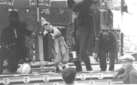
Text

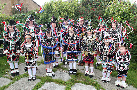

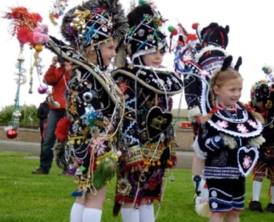
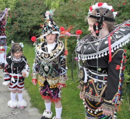
The girls of South Ronaldsay, Orkney, dressed as Clydesdale horses for the annual Festival of the Horse.
Scottish fashion designer Charles Jeffrey (Loverboy) based his FW20 collection on these elaborate costumes.
#orkney#tradition#festival#costume design#costumes#south ronaldsay#festival of the horse#scotland#museum of British folklore#folklore#ploughing#agricultural history#clydesdale#horses#charles jeffrey#charles jeffrey loverboy#fw20#fashion#embroidery#embellishment
5 notes
·
View notes
Text

Today's Flickr photo with the most hits: this interior shot of the neolithic Tomb of the Eagles, South Ronaldsay, Orkney.
The entrance shaft is on the left, a low tunnel accessed on a flat trolley.
The burial spaces are off this central corridor. They contained the skeletal remains of over 300 persons, and talismanic (?) findings of whote-tailed sea eagles, which gave the tomb its name.
0 notes
Text
The Tomb of the Eagles
On the Island of South Ronaldsay in the Orkney Islands north of Scotland is a peculiar tomb. The site is a chambered tomb, built into the cliff's edge around 3,500 BCE, and it wasn't re-discovered until the 1950s. As you probably guessed from this post's title, the tomb is the final resting place of 8 to 20 people -- and 14 white sea eagles. Recent dating tells us the people were buried in it about 1,000 years before the eagles were.
It's an amazing example of how a neolithic tomb was in use for many generations, and evolved in its meaning over time. Personally, I think its pretty cool that 1,000 years after their ancestors died, someone added eagles to accompany them.
191 notes
·
View notes
Video
Across the Fjord by Tony
#East Mainland#GBR#Newbigging#Orkney#Scotland#United Kingdom#britain#clear sky#europe#geo:lat=58.82122084#geo:lon=-3.02162617#geotagged#hoxa#island#night#rinibar#sky#south ronaldsay#stars#©2021 Tony Sherratt#South Ronaldsay a#2021 09 19 225312#flickr
6 notes
·
View notes
Photo


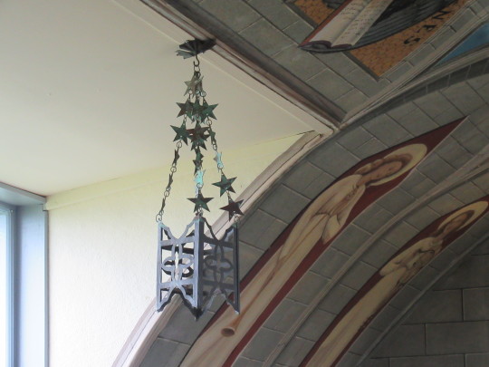

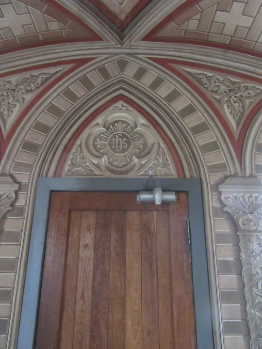
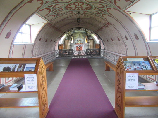
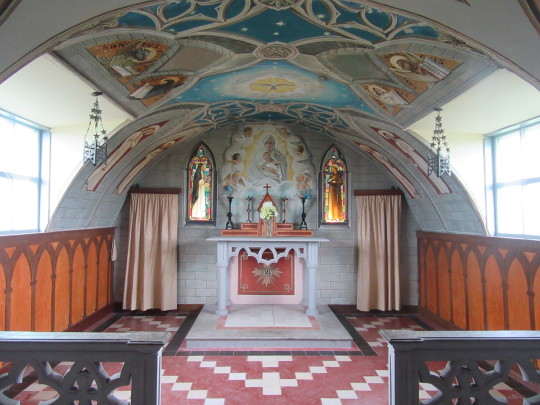
Italian Chapel, Lamb Holm, Orkney, Scotland
Previous
From Kirkwall I turned south and biked over yet more causeways to St Margaret’s Hope, where I’d catch a ferry to John O’ Groats. But on the way there, I stopped by the Italian Chapel.
During World War 2, a number of Italian POWs were kept here and used to build the Churchill Barriers--stone causeways between the easternmost Orkney Islands preventing the German navy from getting to the British anchorage at Scapa Flow and, not incidentally, allowing me to bike between Kirkwall and St Margaret’s Hope.
At any rate, partway through their captivity, the Italian POWs sent a delegation to the British officer in command of them. They had no major complaints, but did want permission to build a church. The officer agreed and gave them two huts, paint, and a number of workers time off to work on the church.
It wasn’t yet done when they were repatriated in 1944, so some of them came back after the war.
The result is deeply moving. With their materials limited to paint, concrete, and beef tins (used in the lamps), the POWs, led by Domenico Chiocchetti, created a church any Catholic would be proud of. Note that the decoration on the walls, ceiling, and around the door is all flat paint. There is no moulding inside.
The exterior of the church is free to view, the interior costs £6. Lamb Holm is located on the ‘main road’ south from Kirkwall or north from South Ronaldsay (there’s only one road, it’s hard to miss).
Next
9 notes
·
View notes
Photo
On September 26th 1290 Queen Margaret, Maid of Norway died, enroute from Norway to Scotland.
Margaret was called Queen but was never crowned. She was known as Lady of Scotland, Margaret of Scotland and the Maid of Norway. The story of her life is very poignant and short. She is widely considered to have been Queen of Scots from 1286 until her death in 1290, although title is disputed
Margaret’s claim to the Scottish throne came from her grandfather, Alexander III. Alexander had come to the throne at the age of 8 and had proved to be a very capable and strong monarch. It was his death at Kinghorn in March 1286 that set the chain of events in motion that led to Margaret being Queen and ultimately The Wars of Scottish Independence.
Alexander’s death, en route to be with his new young bride Yolande de Dreux, threw Scotland into chaos. Robert Bruce (grandfather of Robert I) and John Balliol both made claims for the throne, and to add to the confusion, Alexander III’s widow Yolande said she was pregnant. When her child miscarried or was stillborn, the Scottish Parliament appointed six guardians to look after Margaret.
The Scottish nobility called on assistance from Edward I of England in an effort to secure Margaret’s position. Edward arranged the Treaty of Birgham in July 1290. Under its terms Margaret, Maid of Norway was betrothed to his son Edward (later Edward II of England). In return Edward I guaranteed Scottish independence and agreed to act as ward for the young Queen Margaret.
In September 1290, Margaret set sail in a Norwegian ship from Bergen bound for Leith and accompanied by Bishop Narve of Bergen. Storms drove the ship off course to Orkney, and it eventually landed at what is now, St Margaret’s Hope, South Ronaldsay. Here Margaret, Maid of Norway, died, apparently from the effects of sea-sickness, still aged only eight. Had her marriage to Edward gone ahead, the crowns of Scotland and England would have been united some three hundred years earlier than they eventually were, in 1603. And three hundred years of bloody history would probably have been very different.
As it was, Margaret’s body was returned to Bergen and buried beside her mother, in the north side of the choir, in Christ’s Kirk at Bergen. Before her burial, her father King Eirik confirmed the identity of her body. This is significant because in 1300, a year after the death of King Eirik, a woman turned up in Bergen claiming to be Margaret. There was much popular support for her claim, despite the identification of Margaret’s body, and despite the fact that the woman appeared to be about 40 when Margaret would only be 17. The false Margaret was executed in 1301.
The death of the Maid of Norway in 1290 brought to an end the rule of the House of Dunkeld or the House of Canmore, which had started with the accession to the throne of Malcolm III in 1058. It also paved the way for two years of chaos, with 13 claimants for the Scottish throne having their claims assessed by Edward I of England. The Wars of Independence from England were just around the corner…
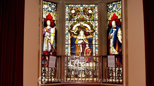
The Maid of Norway is central character in Lerwick Town Hall's wonderful series of stained glass windows featuring characters from Shetland's history.
20 notes
·
View notes
Text

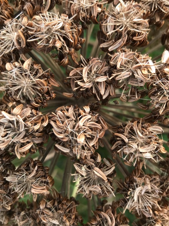
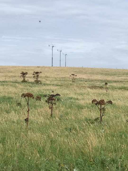

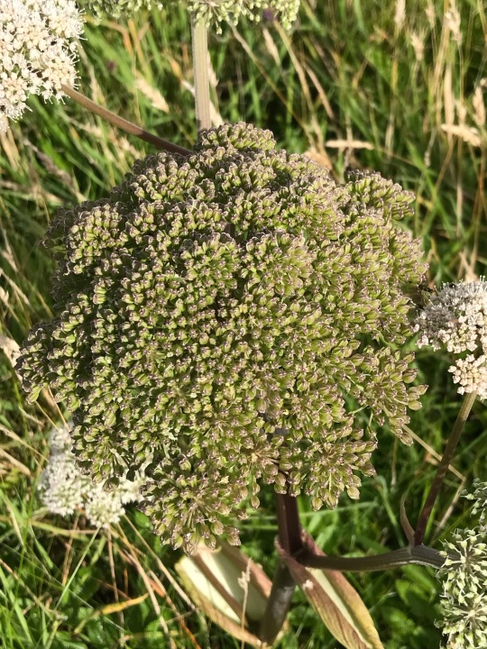
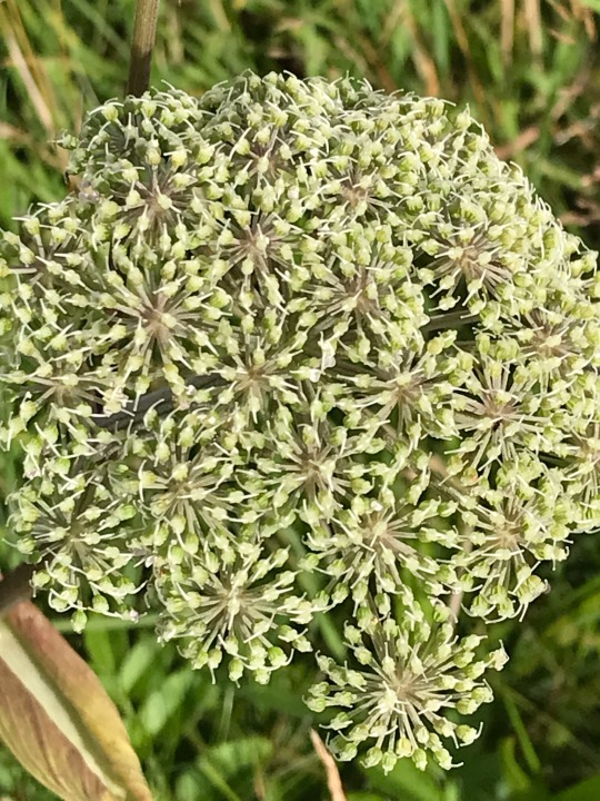
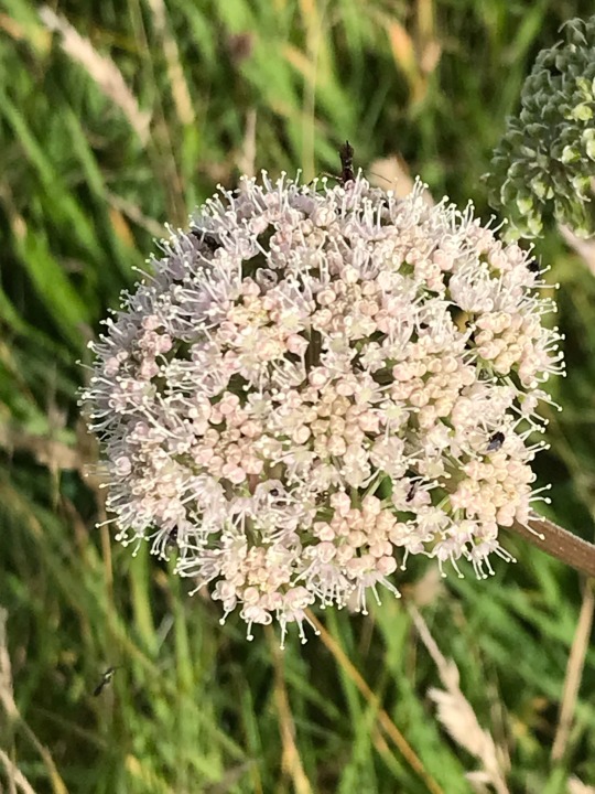

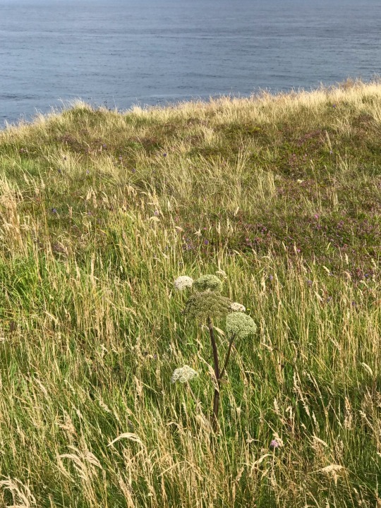
Plant of the Day
Tuesday 20 September 2022
On the cliffs tops of South Ronaldsay, Orkney, the wildflower Angelica sylvestris (wild angelica) can be found. It has now finished flowering and has created large, dramatic seed-heads. In some parts of the world this plant is considered an invasive weed.
Jill Raggett
#angelica#wildangelica#whiteflowers#seedheads#wildflower#clifftop#SouthRonaldsay#orkney#plants#meadow#horticulture#seeds
65 notes
·
View notes
Last Seen Blogs