#Wakhi men
Photo

Young Wakhis dance after celebrating Imamat Day, which marks the anniversary of the day their present (or Hazar) imam succeeded his predecessor. These young men study in big cities away from the mountains, and for them, this celebration is a time to reconnect with their homeland.
MATTHIEU PALEY
#MATTHIEU PALEY#wakhi#dance#celebration#Imamat Day#mountains#mountain#pakistan#national geographic#Ismaili
22 notes
·
View notes
Photo
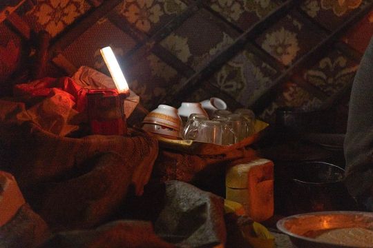
Kitchen. In Wakhi camps, only men stay winter upland. Roles are clearly distributed, among them a cook. Every three-four days he bakes bread for the eight other herders and occasional guests. He prepares the dairies from the light milking in the cold season, enough to fatten up our tea and skim some cream aside. Cups dry until the next round, evening sitting together around the fire. #tea #conviviality #cook #Afghanistan #kitchen #Pamir #light #photography #yurt #Wakhan #everyday #routine (at Vakhan, Afghanistan) https://www.instagram.com/p/CG7QMOuBc22/?igshid=piuv20l8viul
2 notes
·
View notes
Text
A guide for traveling Tajikistan (Tips + 3-week itinerary)
The ex-Soviet Republic of Tajikistan is a truly wild country that you don’t want to miss in your Silk Road journey.
Home to the Pamir range, one of highest mountain ranges in the world, the mountains of Tajikistan attract the most adventurous travelers, especially those wanting to drive the M-41, or Pamir Highway, an impressive road and architectural masterpiece that goes through some of the remotest and most beautiful mountain scenery in Central Asia.
With tourism increasing year by year, the country is daily becoming more prepared to receive international travelers and, after spending 1 month in the country, I have this compiled this guide that contains all the tips needed for traveling to Tajikistan, plus a compelling 3-week itinerary.
Read: Ultimate guide to the Pamir Highway
Visa
Travel Insurance
Best time to visit
The country, the people and its culture
Getting in
Safety
Scams and corruption
Money
Food and alcohol
Transportation
Useful books
Internet and SIM Card
Accommodation
Itinerary
More information
Total transparency! – If you like my website and found this post useful, remember that, if you buy any service through of my links, I will get a small commission at no extra cost to you. These earnings help me maintain and keep Against the Compass going! Thanks
Do you know what a VPN is? A Virtual Private Network allows you to access blocked sites when you travel, as well as it lets you access content only available in your home country (like Netflix), plus it prevents hackers from stealing your personal data. Learn here why you should always use a VPN when you travel
How to get a visa for visiting Tajikistan
Most likely, you can get an e-visa – Most nationalities can apply for an e-visa through the official portal, valid for any port of entry.
The visa costs 50USD, is valid for 45 days, single entry and takes 1 or 2 working days.
Double entry visa – If you want one, you will have to get it through the embassy. Most people who want a double entry visa do so because they want to travel the Afghan Corridor, accessible from Ishkashim.
If this is your case, these are the requirements:
1 Passport valid for at least 6 months of validity and with two empty pages
Passport copy and visa copy from the country you are applying from
2 Passport photos
US Dollars
I applied for one in Bishkek, Kyrgyzstan, and got it on the same day.
My double entry visa for visiting Tajikistan
GBAO Permit – The Gorno-Badakhshan Autonomous Region (GBAO) is the region located in the east of Tajikistan, where the Pamir Highway and Wakhan Valley are.
If you want to visit it, you must tick the GBAO checkbox in the application form. If you are applying at the embassy, make sure to tell them, so you get the extra stamp.
By the way, the GBAO permit costs an additional 20USD.
Read: 30 Tips for traveling to Kazakhstan
Trekking in GBAO – Things to do in Tajikistan
Travel Insurance for Tajikistan
Eastern Tajikistan, where the Pamir Highway is, is a high altitude area, averaging around 4,000 meters above sea level.
You should know that, if you read the fine print, most insurance companies won’t cover you from 2500-3,000m and above, so you better check before you travel to Tajikistan.
World Nomads, however, does provide cover, including their most basic policy, which already covers for trekking at 4,000m.
CLICK HERE TO GET YOUR FREE QUOTE FROM WORLD NOMADS
If you want to know more options, read how to find the best backpacking insurance
Best time to visit Tajikistan
If you plan to do some trekking in eastern Tajikistan, you should come in summer.
I remember being in Alichur, a small village in the Pamir Highway and one of the coldest places in Central Asia, and, in the morning, during August, it was -5ºC and there was a freezing, strong wind, so it felt even colder.
Imagine the weather there during the rest of the year.
Me, at the top of Gumbezkul Pass. It was the month of August and it was absolutely freezing – Best things to do in Tajikistan
Nevertheless, the Pamir Highway is open all year long so, if you are self-driving, you can drive it at any time. Actually, my friend Joao Leitao from Nomad Revelations drove it in winter.
On the other hand, the Fann Mountains in west Tajikistan are at lower altitude, hence warmer, so they can be visited during spring and fall.
I did the 7 lakes trek in September and it was particularly hot!
The Fann Mountains – Is travel to Tajikistan safe
The country, the people and its culture
After the Soviet Union’s dissolution in 1991, Tajikistan went through a dark period of Civil War that lasted pretty much until 1997 and it was not only in 1999, that they formed an actual, stable government, even though Emomali Rahmon, who is still today President of Tajikistan today, had already been ruling from 1994.
It was one of the countries most affected by the Soviet Union’s breakdown, as all their economy and development depended on the Russians so, after getting their independence, the country went to ruin.
Murghab and all the Pamir highway is really poor – Should I travel to Tajikistan
That crisis can still be seen today, as this is clearly the least developed of all the Stans (not counting Turkmenistan), a country with high rates of unemployment, and the fact that most of their infrastructure is still from the Soviet Union times.
It is also the least Westernized country, also due to the fact they are far from Russia so, unlike Kyrgyzstan and Kazakhstan, their cultural influence is not that visible, hence they have less international exposure.
Actually, after having some conversations with quite a few highly educated Tajiks in Dushanbe, I felt that they don’t really know anything about what is going on in the outside world.
A Soviet truck
They were people with very few Western values and no apparent ambition who asked me many times why I would ever want to travel to Tajikistan.
Moreover, Tajikistan is one of those fake democracies where elections are celebrated but there is only one political party, so the same President has been ruling since 1994.
There is no freedom of speech and I remember when my Australian friend, Sam, was talking to a local man for about half an hour at the main square in Dushanbe, a man in a suit came to ask what was going on and invited him to leave.
This means that, still today, the Government doesn’t like their citizens to get international exposure.
The Tajiks – Tajiks are a Persian ethnic group who live mainly in Tajikistan and Afghanistan, but also in Xinjiang (China) and Uzbekistan.
Actually, nearly half of the total Tajik population live in Afghanistan.
Lovely Tajiks in Khujand – tRAVEL TO tAJIKISTAN
Nevertheless, you should know that, like all the Stans, Tajikistan is ethnically mixed and, actually, most of the people living in the Pamirs are Kyrgyz, whereas those in the Wakhan Valley are Wakhis, so if you want to meet the real Tajiks when you are traveling to Tajikistan, you will have to explore Dushanbe and the western part of the country.
Kyrgyz people from the Pamirs
Language – Tajik, which is a dialect of Persian (the language spoken in Iran and Afghanistan) is the official language. Russian is, of course, widely spoken among most people. English tends to be a problem across all the country. I recommend you learn some basic Russian before you visit Tajikistan.
Religion – Tajiks are Suni Muslims but, like in all Central Asia, religion is not a very big deal. However, I felt that Tajiks were the most religious people in all Central Asia, especially those from the Fann Mountains. I remember that the men there never said hello or shook hands with my girlfriend.
Read: 65 Tips for traveling to Uzbekistan
Tajik women – Tajikistan travel guide
How to travel to Tajikistan
Travel to Tajikistan by air
Traveling to Tajikistan by air is very easy, as there are many international flights connecting Dushanbe with Europe.
If you intend to travel the Pamir Highway, many people fly into Osh, the largest city in southern Kyrgyzstan and the beginning of the M-41 on the Kyrgyz side.
Travel to Tajikistan by land
Moreover, if you want to travel to Tajikistan by land, know that it shares a border with 4 countries and most of them have multiple border crossings.
Kyrgyzstan – There are 6 border crossings and 4 of them are open to foreigners. The most obvious is the Kyzyl Art border crossing, which is the one that follows the Pamir Highway. For more information, read the latest Caravanistan updates.
Kyzyl Art pass: Tajikistan-Kyrgyzstan border – Tajikistan travel guide
Uzbekistan – There are 5 border crossings with Uzbekistan and all of them seem to be open. I personally crossed the one at Konibodom, that links Khujand with the Fergana Valley, but if you don’t plan to visit that region, it is not very convenient. The Oybek border crossing is the one that connects Khujand with Tashkent and Penjakent is the one that connects the Fann Mountains with Samarkand. For more information, check the latest updates on Caravanistan.
Afghanistan – You can cross at Ishkashim, the gate to the Wakhan Corridor and a very safe part of Afghanistan; or the border crossing south of Dushanbe, which is also open but leads to Kunduz, a not very safe part of Afghanistan. Both borders are open but, if you plan to travel back to Tajikistan, remember to have a double entry visa.
China – Apparently, Kulma Pass is open now, as long as you have a valid printed visa on your passport. For more information, check the latest updates on Caravanistan.
Kulma Pass leads directly to the Karakoram Highway that connects Kashgar with Islamabad in Pakistan. Read here the full guide.
Read: 75 Tips for traveling to Kyrgyzstan
Uzbekistan – Tajikistan border crossing
Is it safe to travel to Tajikistan?
In summer 2018, 4 cyclists traveling across Tajikistan were murdered in Danghara, an area relatively close to Dushanbe. ISIS claimed the attack.
That accident triggered a big concern among many travelers and the Tajiks are concerned that it might affect their tourism negatively.
This unfortunate event, however, has been a one-off thing and I personally think that it shouldn’t affect your decision to travel to Tajikistan. A similar case happened in Morocco in December 2018 when 2 Scandinavian girls were killed and, so far, it doesn’t seem that tourism has been affected.
Aside from that, Tajikistan is a safe country with very low crime rates.
Tajiks are always friendly – Is traveling to Tajikistan safe
Scams and corruption when visiting Tajikistan
I still remember being in the car with a homestay owner, on our way to Khujand, when he gave some money to a policeman after stopping at one checkpoint.
Why did you give him money? – I said
Oh, this is just the standard bribing procedure. If we don’t pay him, then he would try to find a reason to fine or arrest us.
The corruption in Tajikistan is a well-known fact and some of these police officers also try to rip off foreigners but luckily, as tourists, there is not much they can do to you unless you are credulous and believe their lies.
Common scams include policemen telling you that there is a problem with your Tajik visa or making you pay an entrance fee to a place that, obviously, doesn’t require an entrance fee.
Dude, just think:
How the hell there is going to be something wrong with your visa?
And also,where have you been where you need to purchase an entry ticket from a policeman?
Just say no and continue with your business.
Epic landscapes
Money when you travel in Tajikistan
The official currency is the Tajik Somoni and, in February 2019, 1USD = 9.50SOM
ATMs and credit cards – You can find ATM’s in the big cities (not in the Pamir Highway).
How much does it cost to travel to Tajikistan
It really depends on where you go and, ultimately, how you travel the Pamir Highway.
Typically, meals cost something between 1 and 3USD and budget homestays around 10-15USD, which tends to include dinner and breakfast.
In Dushanbe, you can find dorms for 3-4USD and the local transportation ranges from 2 to 10USD, depending on where you go.
For all costs referred to the Pamir Highway, read my guide.
Read: 80 Tips for traveling to Iran
We were on a low budget, so we hitchhiked the entire Pamir Highway
Food and alcohol when visiting Tajikistan.
Heads-up.
Like in all Central Asia, the food won’t be the highlight of your visit in Tajikistan.
In the Pamirs and different homestays, you are likely to eat shorpo for every meal, which is a meat broth.
In local restaurants, you will just find things like shahslik, meat skewers; lagman, a noodle soup; manti, fatty meat dumplings; or plov, rice fried in lamb fat.
As per alcohol, as in all ex-Soviet countries, beer and especially vodka are found everywhere.
Lagman is the comodin dish. After eating 100 bowls of it across all Central Asia, I really hated it but since I like pasta a lot, I could handle it more than other dishes
Transportation when you travel around Tajikistan
The below information refers to types of transportation in western Tajikistan, not the Pamir Highway. For this, read my guide to the Pamir Highway.
Marshrutkas – Marshrutkas is what former Soviet countries call their public minivans. They are really cheap and travel between most towns and cities.
Local shared taxis – Actually, we used more local shared taxis than marshrutkas and, as far as I could see, they are the most preferred option among locals.
Hitchhiking – Highly doable and easy! We actually had one of our most crazy hitchhiking experiences, when we spent more than 48 hours in a truck, on our way from Khorog to Dushanbe.
Traveling in a mini UAZ-452 – A classic Soviet van
Books for traveling to Tajikistan
Tajikistan Travel Guide by Bradt – The most comprehensive travel guide to Tajikistan. I bought all the Bradt guides to Central Asia (e-Book format). They are, by far, the most insightful guides I have ever read recently.
CLICK HERE TO CHECK PRICES ON AMAZON
Central Asia Travel Guide by Lonely Planet – I am not a fan of this guide, but if you are traveling to all the Stans and want to buy just one book, it is a good choice as well.
CLICK HERE TO CHECK PRICES ON AMAZON
Internet and mobile when traveling in Tajikistan
Wi-Fi – From Murghab to Khujand and Dushanbe, the Wi-Fi connection when you are traveling in Tajikistan is one of the worst I have ever seen. In Dushanbe, the Wi-Fi in my hostel was particularly bad and then every day I would go work to a fancy café and the internet was down every now and then. In the Pamir Highway and the Wakhan Valley, Wi-Fi doesn’t exist.
SIM Card – 3G was just OK anywhere outside of the Pamir Highway. I bought MegaFon and, for a few Somonis, I got plenty of GBs.
Accommodation in Tajikistan
Homestays – On the Pamir Highway, homestays are the way to go. I recommend you stay in random homestays, not in the popular ones. This way, the benefits will be spread more equally plus random homestays are cheaper.
Hostels – Hostels are popular, from Khorog to Dushanbe and Khujand. Click here to check all the available hostels in Tajikistan!
Hotels – In Khorog, Dushanbe, and Khujand you can find hotel options for mid-range travelers. Click here to check all the available hotels in Tajikistan!
Yurts – In the Pamirs, you can also find nomadic yurt camps where Kyrgyz nomads live.
A yurt camp somewhere in the Tajik Pamirs
Traveling to Tajikistan – 3-week Itinerary
I traveled to Tajikistan from Kyrgyzstan via Kyzyl Art Pass and left through Uzbekistan at Konibodom, so this Tajikistan itinerary reflects the direction I took.
Map of the Tajikistan itinerary
Things to do in Tajikistan – Pamir Highway (8-9 days)
Built by the Soviets in 1930, the Pamir Highway is an architectural masterpiece that goes through some of the remotest landscapes you can ever imagine.
Officially, it starts in Osh (Kyrgyzstan) and ends in Afghanistan but the highest and most beautiful part of it lies in Tajikistan.
The following information is just a small summary.
For the full guide, read my 6,000-word guide to the Pamir Highway.
The stunning Pamir Highway – Tajikistan travel itinerary
How many days are needed for the Pamir Highway?
Well, it is really hard to say. We spent more than 2 weeks between the Pamir Highway and the Wakhan Valley but that is because we stopped in many places plus we also did a 3-day trek.
Normally, most people take a 5 or 7-day tour (starting from Osh), which also includes the Wakhan Valley, but, to be very honest, it is not enough to explore the side valleys, which is where the most stunning landscapes are.
Amazing road! – Tajikistan travel itinerary
If you don’t have the time, I get it but, if you do, here are all the places you need to stop at:
Karakul (1 night) – The first big settlement coming from Kyrgyzstan, Karakul has a very big lake and with some pretty cool snow-capped mountains at the background.
Murghab (2-3 nights) – Murghab is the main town on the M-41 and a base for visiting other places and valleys. We first stayed 2 nights because we waited for a festival and then we stayed a 3rd night after coming back from the trek.
The mosque in Murghab – Tajikistan itinerary
Gumbezkul Pass trek (2-3 nights) – If you have your own car, you can do this trek in 1 day but we did it in 3, cause we walked all the way from Murghab and spent one amazing night with some real nomads in the middle of nowhere. For more information, I wrote the full guide for Everything Everywhere: How to trek the Gumbezkul Pass.
Alichur (1 night) – Very cool landscapes, yaks, trekking and Marco Polo sheep safaris.
Madyian Valley, close to Murghab – things to do in Tajikistan
Bulunkul (Stopover) – The coldest place in Central Asia is home to a beautiful lake. The trek from Alichur to here is a popular one. You can find a few homestays.
For most travelers, the Pamir Highway is, definitely, one of the best things to do in Tajikistan.
For more information, don’t forget to check my guide to the Pamir Highway
The festival we attended in Murghab – Things to do in Tajikistan
Places to visit in Tajikistan – Wakhan Valley (3-4 days)
Many travelers tend to classify the Wakhan Valley as part of the Pamir Highway (M-41), which is completely wrong because they are 2 different places.
Actually, to reach the Wakhan Valley you need to leave the road and drive towards Afghanistan for several kilometers.
The Wakhan Valley
Anyways. The Wakhan Valley is one of my most favorite places in entire Central Asia and my most favorite place in my Tajikistan itinerary.
And the reason is that, besides being home to intriguing and jaw-dropping landscapes, the Wakhan is of great historical importance as the ancient border between North Asia and South Asia and on the remarkable Silk Road route, which can be seen in the many fortresses and other sites of cultural heritage there.
Moreover, in the 20th century, the Wakhan Valley marked the border between the Soviet Union and Afghanistan and the Soviet tanks came through here to invade Afghanistan in the 70s.
Today, the river you will go along during your whole journey, whose other side is in Afghanistan, is the main entry point for smuggling products, especially heroin, and, from the window of your car, you can wave and say hello at the many Afghans across the river, from whom you are separated by only a couple of meters.
Once again, this is a small summary, so for more information, don’t forget to check my guide to the Wakhan Valley in Tajikistan.
The views from Khaaka fortress – Left side is Afghanistan and right Tajikistan – Places to visit in Tajikistan
These are all the places we stopped at:
Langar (1 night) – The first big settlement you find is Langar.
We personally didn’t like Langar, as it is the only place in the Wakhan where the locals are very pushy in trying to promote their homestays, plus it is actually far from the river.
I recommend you continue for a few kilometers to Hisor, a more genuine village and with nicer views to actual Afghanistan.
Vrang (stop) – Vrang is another old village that has an ancient Buddhist temple. It is worth stopping for a few hours.
Yamchun (1 night) – The most striking fortress in the Wakhan, which stands with the Afghan Hindu Kush on its background.
Yamchun fortress – Places to visit in Tajikistan
It also has some famous hot springs called Baby Fatima that are believed to have some fertility benefits.
Namadgut (1 night) – There is nothing in particular to see here but travelers don’t tend to stop here, so it is quite untouched. That is why here we had the best cultural experience with a local woman who blessed us with her hospitality.
Kaakha Fortress – The second most famous fortress after Yamchun has also great views to Afghanistan.
Ishkashim (1 night) – The main town in the Wakhan Valley. It used to hold the Afghan market in no man’s land but it is temporarily closed. It is also the border to Afghanistan for those interested in doing the Afghan Wakhan corridor.
For more information, read my guide to the Wakhan Valley
Wakhi people – Best things to do in Tajikistan
Tajikistan itinerary – Khorog (2 days)
After nearly two weeks of showering with buckets, using holes and bushes as toilets, exclusively eating shorpo and with no internet at all, getting to Khorog felt particularly good.
It is not a very big town but it has a good local market where you can buy many food items that were not available in the Pamir Highway, like cheese, and supermarkets with cold beer.
There is also an Indian restaurant that tends to be filled with travelers and a really good Tajik restaurant by the river, serving high quality grilled meat and other stuff.
Other than this, Khorog is a place to just chill, where we spent 4 days just catching up with work and filling our bellies with decent food.
By the way, the famous Afghan market takes place on Saturday.
Afghan people in the Afghan market of Khorog – A travel guide to Tajikistan
Where to stay in Khorog
Backpacker Hostel – Pamir Lodge – All right, it is a cool place and there is a friendly atmosphere. However, the hostel has the capacity for nearly 100 people and it only has two toilets and two showers, so when I came in August, it was very difficult to find them empty, apart from being quite dirty of course.
Backpacker Hostel – Hostel Do Nazarbayg – An alternative to Pamir lodge. You will find fewer backpackers but the location is much better and it is not that busy.
Click here to see the latest prices
Guest House – Riverside – A quieter, more homestay-style place.
Click here to see the latest prices
The journey to Dushanbe – 1 day
The road to Dushanbe is a very long way.
Shared taxis take around 12 hours and cost 30USD. They leave from near the market but you need to be there early, 7am at most.
We arrived before 8am and there weren’t any marshrutkas or taxis left, so we decided to hitchhike and it took us 3 days, spending more than 48 hours in a truck.
The distance is only 518km but the road is really bad but beautiful and interesting as, again, it goes along the Afghan border for the most part of it.
The road from Dushanbe to Khorog: the left side is Afghanistan and the right Tajikistan
Things to do in Tajikistan – Dushanbe (2 days)
The capital of Tajikistan is another place to chill for a few days while you collect some visas, like the Uzbek or Turkmen visas.
Well, not the Uzbek visa anymore, as from February 2019, they started issuing visas on arrival. Check my Uzbekistan travel guide for more information.
Dushanbe has cafés with real coffee, a variety of restaurants and a few pubs where to hang out at night.
What I liked about Dushanbe is that it was my first introduction to the real Tajikistan, as most people you meet in the eastern part are Kyrgyz, Wakhis or Pamir, so you will see a significant difference with the people living here, especially in the way women dress.
Don’t forget to check the main bazaar and the Rudaki Park, which holds the second tallest flagpole in the world
Where to stay in Dushanbe
Backpacker Hostel – Green House Hostel– We spent so many days here because the hostel was really comfortable. Comfy beds, a big kitchen and a living room with awesome couches.
Click here to see the latest prices
Budget Guest House – Hello Dushanbe – If you want a less backpacker-friendly place, Hello Dushanbe may be slightly more expensive but the facilities are great. It has both private rooms and a dorm.
Click here to see the latest prices
Lovely Tajik women
Hissor Fortress – Day trip from Dushanbe
If you are bored to be in Dushanbe, we also did a day trip to a fortress named Hissor, which was built by the Uzbeks in the 18th century, as this part of Tajikistan used to belong to the Emirate of Bukhara. The north was part of the Russian empire.
All right, the fortress itself was boring, as it was overly refurbished, but we always like to get out of town, take a local marshrutka and just see other towns, so it was worth it only for this reason.
How to get to Hissor fortress
From Dushanbe, you need to take a marshrutka to a town named Khisor. From there, take a taxi or hitchhike back to the fortress which is 4 or 5km away.
The fortress
Places to visit in Tajikistan – Penjakent and the Fann Mountains (3-4 days)
Once again, this is a small summary.
For all the information needed, read my guide to the Fann Mountains.
While they are not as stunning as the valleys around the Pamir Highway, the Fann Mountains are also very pretty and their main advantage is that, unlike the Pamirs, they are heavily populated and filled with several tiny villages where actual Tajik people live.
Tajiks from the Fanns
Therefore, visiting the Fann Mountains is a great opportunity to discover the real Tajik rural life, so different from anything you have seen during your Tajikistan itinerary.
Most people come to the Fann Mountains to visit Iskanderkul lake but I recommend going to the area around Penjakent and doing the 7 Lakes Trek.
Trekking in the Fanns
The reason is that, although Iskanderkul is a beautiful lake, no people live there plus it is always busy with domestic tourists, which isn’t a bad thing, but you won’t see much of the local culture.
On the other hand, the 7 Lakes trek starts in Penjakent and goes through several tiny villages where you can do homestays.
From Penjakent, we took a UAZ-452, the classic Soviet mini-van, and drove to a village named Rachnapollon.
That area is really off the beaten track, so the driver himself invited us to stay at his place, for free, but we decided to give him a generous tip because he had been feeding us.
How to get to Penjakent
First, take a local shared taxi from Dushanbe to Penjakent, which costs 70TJS (8USD). It is a 230km journey.
In Penjakent, for just a few somonis, we got in the UAZ-452 to Rachnapollon, from where we started walking on the next day.
Remember to check my guide to the Fann Mountains
Random people during the trek
Places to visit in Tajikistan – Khujand (2-3 days)
Khujand is the purest Tajikistan in its most genuine form and one of the oldest cities in Central Asia (2,500 years old).
It is the second largest city in the country, a city with little international exposure that has kept its traditional values.
Most travelers use it as a mere transit point, as it is close to the closest border with Tashkent, but I recommend spending here two nights at least.
Arbob Palace Tajikistan
Things to do in Khujand
Don’t forget to check the traditional bazaar, one of those traditional bazaars where everybody asks for a photo and gives you free stuff; and all the mausoleums and historical buildings around the main square. The Arbob Palace is also worth checking out.
Mosques in Khujand
Where to stay in Khujand
Budget Hostel – Somoni Hostel – The best choice for backpackers and a really cool hostel.
Click here to check the latest prices
Budget Hotel – Golden Apartments – The alternative to a backpacker hostel.
Click here to check the latest prices
Khujand’s bazaar
More information for visiting Tajikistan
Here you can find all my articles and travel guides to Tajikistan
And here all my guides to Kyrgyzstan, Uzbekistan, and Kazakhstan.
Traveling to Iran? Find all my articles here
from Cheapr Travels https://ift.tt/2WmI1Xa
via IFTTT
1 note
·
View note
Text
New Post has been published on Trekking in Pakistan
New Post has been published on http://bit.ly/2TOVAvT
Werthum Pass
Duration 7 days Distance 52.4km Standard Very demanding, technical Season Mid-June-September Start China Camp Finish Raminj Zone and Permit open, no permit Public Transport yes Summary Werthum Pass offers a rugged mountaineers’ route between the Batura Glacier and Chapursan’s Lupgar Valley through unvisited areas with scope for climbing and watching wildlife.
Werthum (‘millstone’ in Wakhi) is an infrequently crossed nonglaciated pass (5147m) linking the Batura Glacier to Chapursan’s Lupgar Valley to its north. The pass offers an alternative exit from the upper Batura Glacier, especially attractive for those climbing in the Werthum Valley. This rugged side valley north of the Batura Glacier has some easy nontechnical snowy peaks, and several technical peaks ranging from 5400m to 5900m at the valley’s head and along the Shireen Maidan (sweet field) Glacier. The views from the pass include the six Batura peaks and Shishpar. Crossing Werthum Pass isn’t technically difficult, but requires basic mountaineering skills.
PLANNING
What to Bring
A rope, ice axe and mountaineering equipment necessary to cut steps in the ice cornice on the north side of the pass are required (see Mountaineering Equipment,). Crampons aren’t necessary when crossing from south to north, but are when crossing from north to south. When trekking with porters bring a tarp or tent for their use because no huts exist for the two nights between Kukhil and Harkeesh.
Maps
Refer to Maps under the Batura Glacier trek (p). The Swiss map incorrectly marks the trail between Shireen and Maidan and Werthum Base Camp (unmarked), and misrepresents the confluence of the streams that form Werthum Nala. The actual trail is on the opposite side of the river from where the trail is drawn on the map; the map has it backwards. Unsuspecting trekkers have dangled on nasty scree slopes and cliffs trying to follow the trail depicted on the map. Werthum Pass isn’t marked and the glacier on its north side is much smaller than the map shows. Harkeesh isn’t marked either. It’s on the south side of the Lupgar River along the first side stream west (left) of the place name Purzin.
Guides and Porters
Hiring a local guide and porters is unavoidable. Only four Passu men-Qamar Jan, Sanjar Beg, Ali Aman and Safdar Hussain- know the route over the Werthum Pass, although more will learn the route after the authors’ crossing and opening of this route in July 2000.
When crossing from north to south, hire men from Raminj or Khaibar. Ghulam Sar- war from Khaibar and several men from Raminj also know the route. It may, however, be difficult to find any porters willing to do it, because of the steepness and difficulty from this direction.
Stages
Passu porters ask for 11 stages total between Passu and Raminj, although it’s only 10 stages. Passu to Guchesham or Shilmin is 4½ stages total, but porters usually charge five stages for this distance (see the Batura Glacier trek, for more details). They also ask for one stage between Shilmin or Guchesham and Shireen Maidan, which should be half a stage, thereby effectively inserting an additional stage, much to their benefit. The five stages beyond Shireen Maidan are: (1) Werthum Base Camp; (2) Werthum High Camp; (3) Shikar Gah; (4) Harkeesh; and (5) Raminj.
GETTING TO/FROM THE TREK
To the Start
See the Batura Glacier Trek for a description of how to reach China Camp.
From The Finish
See the Lupgar Pir Pass trek for a description of where to go from Raminj.
The Trek
Days 1-2 : China Camp to Yashpirt
2 days, 16.6km, 872m ascent
See Days 1-2 of the Batura Glacier trek for the description between China Camp and Yashpirt.
Day 3 : Yashpirt to Shireen Maidan
6 hours, 16.9km, 586m ascent
See Day 3 of the Batura Glacier trek for a description of the 4½- hours walk between Yashpirt and Shilmin. From Shilmin, the trail up the Werthum Valley leaves the Batura Glacier’s north margin bending 90 degrees and follows the Werthum Nala’s true right (west) bank north-east. Massive scree slopes on both the valley’s east and west walls guard its entrance. Stay close to the hillside (on the left) 15 minutes to the place where dwarf willows (chikor) grow. Begin a steady climb over scree on a faint trail. Early in the season, when snow is melting, be cautious for extreme rock-fall danger. After 30 minutes, the trail reaches the top of the scree and continues level for 15 minutes to Furzeen. The predominant birches (furz) and scrub junipers shade this attractive grove where a seasonal stream trickles. Ibex frequent the opposite rocky slopes as they migrate between the Batura Glacier and Khaibar Nala via the Shireen Maidan Glacier. The trail descends steeply a short distance to the river, and follows the river bed to the confluence of the Werthum Nala and the Shireen Maidan Glacier’s outwash Stream. Cross the Werthum Nala via two enormous adjacent boulders that bridge the torrent 300m upstream from the confluence, or ford the river when water is low. Along the true left bank at the confluence is a level camp site, sheltered from the wind, with six stone circles. A spring trickles near the river’s edge. Shireen Maidan (3888m) is a preferable camps site to Shilmin, well worth the additional 1½ hours’ walk. The peaks above the glacier offer climbing possibilities (see the boxed text ‘Peak Possibilities’,).
Day 4 : Shireen Maidan to Werthum Base Camp
3 hours, 3.8km, 475m ascent
Recross the river to the Werthum Nala’s true right (west) bank and immediately ascend the steep scree slope on a yak trail to the grassy slopes above. Traversing high above the river gorge, the trail crosses three small ravines, the last two of which offer clear water. Before the second stream, 1½ hours from Shireen Maidan, a difficult section of trail rounds a yellowish rock face called Dzug Band (literally, ‘difficult yak trail’ in Wakhi). A few minutes farther ahead, a house-sized overhanging boulder offers shelter and marks the beginning of the huge area Known as Werthum, which extends all thye way to the valley’s head. Fifteen minutes past the third stream the going gets a little easier, and a cauliflower like edible plant (yamush) and purple flower (bozlunj), whose dried petals can be used to make a tea that assists with acclimatization, pop up between the shale, ephedra and patches of grass.
The trail descends to the river where it disappears among rocks and boulders along the river’s true right bank. Stay close to the water’s edge, hopping rocks and scampering across boulders 15 to 30 minutes. This section could be difficult in the afternoon when water levels are typically higher. The route then fords the Werthum Nala to its true left bank shortly beyond the confluence with a side stream. This is the outwash stream coming from the unnamed glacier to the east. Once across the river, a trail ascends the steep rhubarb- dotted scree slope five minutes to a cairn at the top.
A lone stone circle, which is used as a porters’ shelter, marks Werthum Base Camp (4363m) in the middle of an exposed, broad grassy plateau above the confluence of the two unnamed streams that join to form Werthum Nala. The stream from the north-west issues from the glacier lying at the base of Werthum Peak, whose summit dominates the valley’s head. The other is the outwash stream from the sizable unnamed glacier that descends from several 5000m peaks east of Werthum Base Camp. Water is accessible in a small ravine east of the stone shelter.
This is a relatively short day, but the 475m elevation gain is an argument for stopping. When previously acclimatized, it’s possible to move up to Werthum High Camp. Otherwise, enjoy an afternoon spent strolling in the meadows. It is possible to climb Werthum Peak or one of the other peaks in the area (see the boxed text ‘Peak Possibilities’).
Peak Possibilities
Werthum Valley is a climbing destination with many peaks accessible to trekkers with mountaineering experience. Here are a few options.
Peaks above Shireen Maidan Glacier
Accessible from Shireen Maidan
(Day 3)
A dozen jagged 5000m and 6000m summits encircle the Shireen Maidan Glacier, beckoning climbers to this picturesque side valley. Most climbs are along the glacier’s north side and are mostly mixed ice and rock. These technical routes are more difficult than those accessed from Werthum Base Camp (Day 4). Beneath the Shireen Maidan Glacier’s terminal moraine, 10 minutes east of the confluence camp site on Day 3, is an extremely clear and deep blue- green lake. The grassy area nearby is the base camp.
Werthum Peak
Accessible from Werthum Base Camp (Day 4)
Werthum Peak (peak 5844m on the Swiss map), the valley’s only named peak, is a technical peak north-west of Werthum Base Camp. The three-day climb involves an ascent/descent of 1418m each way. On the first day, move from Werthum Base Camp upvalley to the high camp called Deposit Camp, where porters ‘deposit’ climber’ loads. The route to Deposit Camp stays low along the true left bank of the Werthum Nala’s north-west branch, and crosses the stream descending from Werthum Pass. Continue past the confluence of outwash streams from two glaciers, the southernmost of which ends in an icefall from peak 5539m. Cross the northern glacier’s outwash stream and move onto the black rocky moraine between the two glaciers. Deposit Camp is at the west edge of the northern glacier. On the second day, summit and return to Deposit Camp. Climb steeply to the ridge, staying far to the left (south), and then head right (north) to make the long traverse of the corniced north-south ridge to the summit. A rope, ice axe and crampons are essential, and anchors may be necessary depending on snow conditions. Return to Werthum Base Camp on the third day. It’s a fairly serious route, not recommended for novices.
Unnamed Peaks around Werthum Base Camp
Accessible from Werthum Base Camp
(Day 4) North and north-east of Werthum Base Camp are several unnamed, rounded snow- covered summits. These non-technical ‘walk-ups’ range from 5300m to 5500m, easily engaging most trekkers for a day or two. A rope and ice axe are necessary, but crampons are optional.
Day 5 : Werthum Base Camp to Werthum High Camp
3-4 hours, 3.4km, 612m ascent
From Werthum Base Camp, it’s advisable to set a high camp below the pass. Follow a faint yak trail for 1½ hours, staying very high above the true left bank of the Werthum Nala’s north-west branch. The route traverses north-north-east over stable slate and talus heading towards the rounded peak (5426m on the Swiss map) whose dry slopes are capped by snow. Werthum Pass lies on the ridge that runs south-east between this peak and peak 5315m. The route to the pass is via the side valley immediately in front of peak 5426m. The last reliable clear water flows in the second side stream before the highest grassy patch where yaks sometimes graze.
Cross a dry gully 30 minutes beyond the grass, then head north another 30 minutes up a relentlessly steep rock- and scree-covered hillside. The angle steepens to 25 degrees towards the ridge top, which separates the main Werthum Valley from the barren, snow-filled upper basin beneath the pass. A stream flows through this upper basin and down a steep ravine to meet the Werthum Nala’s north-west branch far below. Traverse scree 45 minutes to one hour to Werthum High Camp (4975m) on a level rocky terrace high above the true left bank of the stream descending from the pass. Water trickles from afternoon snow melt.
It’s possible to break up the Knee-pounding 1658m descent from Werthum Pass to Harkeesh by forgoing a high camp on the south side and crossing Werthum Pass in one long day. This also avoids sleeping at high altitude. The 6.9km between Werthum Base Camp and Shikar Gah Camp can be covered in 6½-8½ hours, with a 784m ascent and 862m descent. The following day, the 1190m descent to Raminj takes 5-5½ hours (8.2km; see Days 6-7 for a description).
Day 6 : Werthum High Camp to Harkeesh
6-7 hours, 6.1km, 172m ascent, 1658m descent
Continue up the snow and scree slope to reach the Werthum Pass (5147m) 45 minutes from the high camp. The pass has 20- to 25- degree slopes on both sides and a permanent 3m to 4m vertical cornice on its north side. Use a rope belay while breaking through the cornice and cutting steps in the ice to reach the talus below the pass. The pass is more difficult before mid-July when there’s more snow and a larger cornice.
Descend the talus and scree slope, then cross a tiny bergschrund onto a small unnamed glacier. Cross the glacier in 15 minutes to moraine and a stream. Cross to its true left bank, and follow the stream down 30 minutes to a level area (4694m). It is possible to make a high camp here when trekking from north to south.
Cross to the stream’s true right bank where the valley begins to drop steeply. Reach the confluence with another stream coming from the south-west in 15 minutes. The route stays along the main stream’s true right bank as the valley turns northward and narrows. When trekking from north to south, take caution to stay to the east (left), and follow the true right Bank of the easternmost (left) stream.
The stream plunges steeply between two enormous reddish rock walls into the canyon-like area called Shikar Gah (4285m) 30 minutes below the confluence. (Some people also call this area Bayeen Shikar Gah, a hunting place named after Bayeen, a man from Chapursan). The level stream bed here has some grass, flowers and rhubarb amid the curious conglomerate boulders that dot the valley floor. Fifteen minutes farther, at this area’s north end, is an overhanging boulder with a level rocky area nearby that offers a reasonable lunch spot and possible camp site. Ibex droppings indicate these wild mountain goats roam the cliffs above.
Begins the steep descent of the boulder choked gorge immediately below Shikar Gah on the stream’s true right bank. The only way down the gorge is literally right at the water’s edge. In very high water, the difficult route might be impassable. For the next 1½ to two hours it hugs the banks. You clamber over boulder after boulder and cross the torrent as needed. Steep scree slopes on both sides of the valley make this the only route.
Eventually you reach the highest pastures along the stream’s true right bank, and pick up a faint, but obvious, livestock trail. The going becomes easier, and in 15 minutes the trail descends to cross a convenient boulder to the stream’s true left bank. Pungent junipers dot the slope. From a ridge five minutes beyond the natural bridge, Harkeesh (‘place of cultivation’ in Burushaski), a level grassy area, is visible below. Descend the steep slope on a poor trail past junipers, wild roses and abundant birches 30 minutes to a log footbridge. Pause to marvel at the colourful sculpted rock cleft which the stream emerges. Follow the path along a canal 15 minutes to Harkeesh (3489m). Water from the canal flows to Harkeesh in the afternoon, but can be dry by morning.
Day 7 : Harkeesh to Raminj
2½-3 hours, 5.6km, 394m descent
See Day 6 of the Lupgar Pir Pass trek for a description between Harkeesh and Raminj (3095m).
0 notes
Text
Hunza the Land of Beauty and Culture
Hunza valley is located in the north of Pakistan. This Valley is Famous for multiple reasons including lush greenery, Land of Glaciers, historical background and most beautiful Cherry blossom view in spring and autumn in the month of October and November. Hunza Valley is divided into 3 parts.
Upper Hunza Gojal
Central Hunza
Lower Hunza
Famous Places to Visit in Hunza Valley
Karimabad
Nagar Valley
Hopper Valley
Sost Border
Gulmit Valley
Duikar Valley
Khunjarab Pass
Gojal Valley
Karimabad:-
Beautiful Valley of Karimabad is the Capital of Hunza Valley. This is the rich and strong historical region. Its most famous places are
Baltit Fort
Queen Victoria Monument
Channel Walk
Altit Fort lies above karimabad in Hunza Valley.
Nagar Valley:
This beautiful Valley is also known as Nagar Khas. Rush Lake is Located in Nagar Valley, which is a high altitude lake. Another Beauty of Nagar Valley is Hopper Village which is famous for its hopper glaciers along with its scientific view.
Another famous place spantik also known as Golden Peak lies in between Nagar Valley.
Sost Border:
It is the Last Village of Hunza Village of Hunza Valley on Karakoram highway. All the Crossing of Passengers and cargo transport between Pakistan and China passes through the highway of this town.
Gulmit Valley:
This valley is also known as Valley of Flowers and Valley of Nine Colours. Birth Lake is Located in this valley. It is also famous for its paramonic view of Passu Cones.
Duiker Valley:
This Valley Lies above the Altit Village. It is famous as a viewpoint. It is often referred to as the Eagle Nest. It gives a viewpoint for Rakaposhi and Lady Finger.
Gojal Valley:
This Valley is Famous for a beautiful lake known as Attabad Lake. It was created as a result of the Attabad disaster in Jan 2010. It is one of the biggest tourist attractions offering many recreational activities.
Khunjarab Pass:
It is the high mountain pass in mountains heading towards Pak China border. There is also a National Park where lies a rear species of now Leopards.
Best time to Visit Hunza Valley.
The time to visit Hunza Valley is March to October. But it becomes rushy during peak summer because the temperature becomes warm at that time.
Best Time to see the beautiful cherry blossum in Hunza Specially in Karimabad is mid of March till the end of April.
How to Visit Hunza valley:
Nowadays there are different travel agencies that are providing packages and tour operators for Hunza Valley. By taking their Hunza tour Packages you can visit the whole Hunza valley at a reasonable price and way even in a rushy day.
Famous Peaks in Hunza Valley:
The Famous peaks of Hunza Valley are
Diram Peak
Rakaposhi Peak
Golden Peak
Ultar Peak
Famous Local Foods of Hunza Valley:
Hirisa
Biyagno Fasanjoon
Feyok Shaa Moskut
Ab-shaa
Shakkurba
Furus Fulka
Palapu
Mamtu
Lhmnd
Chapshuro
Gyal
Local dress of Hunza Valley:
Like most other areas of Pakistan men in Hunza Valley wears shalwar kameez and the Women wear long frocks with shalwar. The thing which makes different is the round cap, which is part of the dressing of both men and women.

People of Hunza Valley:
Like people of the entire Gilgit Baltistan people of Hunza valley are very friendly. People are always ready to help each other as well as outsiders.
Hunzaie keeps their places very clean. There is no security issue in Hunza Valley as it is the safest place in Gilgit Baltistan.
Women’s in Hunza Valley:
Women’s in Hunza Valley are very versatile. They do all the chores of their houses and also runs a small business. They a run various business-like
Making and selling Wooden Handicrafts.
Selling Gem Stones of their Mountains.
Selling Soveneigers.
Seling Woven things.
Selling Local Dry Fruit.
Selling Famous Local dishes on the streets.
Languages in Hunza Valley:
Local languages of Valley are
Burushaski
Shina Language
Wakhi Language
Literacy rate of Hunza Valley:
The Literacy rate of Hunza is more than 77%.
Average Age of Hunzai peoples.
Average Life Spam of People of Hunza is a hundred and twenty years and time may exceed up to 150 years.
This blessing is because of Organic food, homemade oils and a healthy lifestyle.
Crops and fruits of Hunza Valley.
Major crops of this village are:
Wheat
Barley
Potatoes
Major Fruits of Hunza are:
Apple
Apricot
Cherry
Mulberry
Pear
plum
Strawberry
Almond
Main Festival of HunzaValley:
Annual Crop harvesting festival is known as “Ginani” is celebrated in Hunza Valley on 21st June.
Religions in Hunza Valley:
People of Hunza Valley are divided into two groups in terms of religion.
Ismaili Muslims
Shia Muslims
Ismaili Muslims:
These Peoples are the followers of Prince Aaga Khan These peoples have a great impact on Prince Aaga Khan on their lives. They are very much well behaved open-minded open hearts and happiest people of Hunza. They strongly believe in women’s empowerment.
Prince Aaga Khan has a great contribution to the education and health sector. Their major effort is to preserve and restore the culture of Gilgit Baltistan especially in Hunza in the form of Altit & Baltit Fort.
In Altit Fort no of old women’s of the village come towards a specific is where they spend most of their day time by taking rest and gossiping with each other. No Children and men are allowed to that specific part of the fort.
Wrinkles on the faces of these beautiful ladies are telling various stories of ancient times.
Navroz Festival:
This is a huge festival celebrated worldwide by Ismail Shia Muslims. It is celebrated on 21st March at the beginning of spring.
These people recite poetry like Qasidas and Manqabas in their Jammat Khan. Dried nuts, fruits, and grains are distributed among the members of Jammat Khana.
At the time of Navroz festival families arranges gettogether to celebrate meals and to bond strongly with each other.
Games in Hunza:
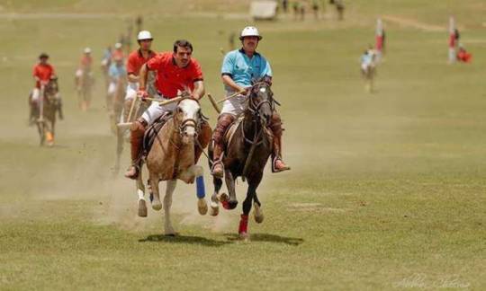
There are various games played by hunzaie people but like the entire Gilgit Baltistan “Polo” is the most famous game of Hunza which was also played at the time of Raja’s large playgrounds are present in entire Gilgit Baltistan as well as in Hunza for Polo practices and festivals. Mostly National level players of polo belong to Gilgit Baltistan as they started to play it from their Childhood.
Why to Visit Hunza Valley
If you are found of History, culture nature than the phrase of “All in 1” is perfectly applicable to Hunza Valley. It is the most beautiful land of Glaciers, lakes Mountains as well as Fruitful trees.
Its beauty increase because of humble residents and versatile culture.
0 notes
Photo

Photo by @bethjwald // Kyrgyz men on horseback cross a broad, snow-covered valley above the frozen Chaqmaqtin Lake in the Little Pamirs of the Wakhan Corridor, a remote and isolated region of northeast Afghanistan. I am continuing this week my celebration of mountains, mountain environment and cultures with this photo from my archive taken on one of several trips to the Wakhan and Afghan Pamirs. A small population of Kyrgyz live a #nomadic life in high broad valleys, moving seasonally with herds of yaks, goats, sheep, camels and horses; they trade yak butter and milk with Wakhi farmers who grow grains and other crops in the lower valleys of the Wakhan, and with traders from Pakistan and from other parts of Afghanistan. It is a hard life and many Kyrgyz suffer from poverty, opium addiction and lack of education, but they also are proud of their culture, their ability to survive and their freedom on the “Bam-i-Dunya” or Roof of the World. Recognizing the beauty, the mountain ecosystems that support wildlife including snow leopard, bear, wolves, ibex and Marco Polo sheep, and the unique culture of the Wakhan District, the Afghan government declared the whole area a National Park in 2014. Dec 11 was the UN’s International Mountain Day but I am honoring it all week. We need more than a day to celebrate mountains and double-down on protecting their critical resources, the mountain ecosystems and diverse cultures that depend on them. Half the world’s population depends on waters that come from mountains and as the mountains warm and shed their ancient cloaks of ice and snow, all of humanity will be impacted. See my feed at @bethjwald for more images from this series! #internationalmountainday #Afghanistan #wakhancorridor #Afghanpamirs #Pamirs #Kyrgyz #nomad #mountainculture #Badakshan #roofoftheworld #bamidunya #nationalpark #onassignment #centralasia #pastoralist #nikonnofilter #nikon @thephotosociety @ilcp_photographers @natgeocreative http://ift.tt/2zcGZDd
1 note
·
View note
Text
30 Photos From Afghanistan That You Won’t See In The News
Traveling in Afghanistan
Afghanistan
Last summer I traveled into the mountains of Afghanistan for a two week backpacking adventure. Not your typical summer vacation destination. Here’s what I witnessed on my journey.
What comes to mind when you think about Afghanistan? War? Terrorism? Osama Bin Laden? The Mother Of All Bombs?
Sure, much of Afghanistan is still dangerous — but there’s also incredible beauty, hospitality and kindness in the country that doesn’t get reported on.
It’s far too easy to vilify or write-off an entire nation when you don’t have to look those people in the eyes. People with the same hopes and dreams as you — to survive, find happiness, and provide for their families.
I was able to experience the positive side of Afghanistan and its wonderful people, up close and personal, during my trip there last summer. It’s since become my most memorable travel adventure to date.
Here are some of my favorite photos of people & landscapes from my 100 mile trek into Afghanistan’s remote and mountainous Wakhan Corridor.
This is the “other” side of Afghanistan that you don’t see in the news.
The Hindu Kush Mountains
Traveling in the Wakhan
Wakhan Corridor
The Wakhan is a rugged and wild region of Northeast Afghanistan, part of Badakhshan Province. It’s a narrow peice of land, about 400 km long, surrounded on three sides by Tajikistan, China, and Pakistan.
Two large mountain ranges dominate the area, the Pamir in the North, and the Hindu Kush in the South. The Wakhan Corridor was created by politicians in the 1800’s during the “Great Game” in an attempt to leave a buffer zone between British India and the Russian empire.
Riding Yaks in the Wakhan
Hitchhiking By Yak
Taking a break from walking, I managed to hitch a ride on a yak for a portion of the route. We ran into a group of Wakhi men leading their yaks through the mountains. While they stopped for tea, they let us borrow their yaks, which we led further into the valley until their owners caught up with us later.
Yaks are the ultimate eco-friendly 4×4 in Afghanistan, able to climb steep rocky terrain and power through icy cold rivers. There are no trees above 10,000 feet, so locals are forced to trek for 3 days to lower elevations with their animals in order to gather firewood for cooking and warmth.
Ruined Stone Shelter on a Vast Landscape
Trekking in the Wakhan
Ancient Silk Road
The Wakhan was once part of the ancient silk road, an important trading route connecting China to Europe. Along with silk, horses, and other goods, it was a highway for armies and explorers too. Explorers like Marco Polo who is believed to have passed through here during the 13th century.
Crossing steep mountain passes and high desolate plateaus, passing caravans of yaks and donkeys loaded with goods, spending the night in stone shelters with traveling merchants — I felt like I was getting a glimpse of what the silk road must have been like all those years ago.
Muslim Shopkeepers in Afghanistan
My Compatriots in the Wakhan
The Many Faces Of Islam
Just like the many different branches of Christianity, there are many different branches of Islam, all with their own beliefs and values. Many people living in Afghanistan’s Wakhan Corridor are Ismaili Muslims, who practice a moderate form of Islam. They number 25 million worldwide, and despise the Taliban.
Their spiritual leader is the Aga Khan, a successful British businessman and Imam who runs the Aga Khan Development Network, a super important charity organization that improves living conditions and opportunities for the poor in Africa and Central Asia.
Footbridge Over the Wakhan River
Untamed Blue Rivers
The Wakhan River runs through the Wakhan Corridor, fed by the high altitude mountains of the Hindu Kush on the border with Pakistan. It snakes its way through the mountains, and is a major lifeline for the people living in this harsh and unforgiving landscape.
The bright blue color of this water is due to reddish hues of the rock formations around it, as well as the crystal clear source (a glacier). Water molecules absorb other colors, like red, more efficiently than blue.
Enjoying the Wild Landscape
Snowy Mountains in August
Epic Mountain Views
When the weather was clear, I was rewarded with incredible views of the mountains like this! The trail was well worn, as it’s used daily by small groups of locals who travel in caravans of yaks or donkeys from settlement to settlement.
The 10 day trek ranged in altitude from 10,000 to 16,000 feet, and we averaged about 10 miles per day of hiking. I began to feel the effects of altitude on my body around 12,000 feet with shortness of breath. At 16,000 feet hiking became even more tiring and difficult.
Snow Covered Yurts
Kyrgyz Settlement in the Wakhan
Portable Yurts
The Kyrgyz people of Afghanistan are semi-nomadic, moving from valley to valley herding their animals to different grazing pastures depending on the season. They live in cozy yurts made of sheep felt, which can be broken down and transported long distances.
Each settlement consists of 2-3 families living and working together. Originally from the area around Kyrgyzstan, their ancestors were kind of trapped in the Wakhan after the Soviets took over Central Asia, forcibly settled nomadic tribes, and sealed off the silk road route.
Sheer Chai Milk Tea
Salty Milk Tea
Both the Wakhi and Kyrgyz people drink large amounts of salty milk tea, called Sheer Chai. It’s served for breakfast, lunch, and dinner. Basically, it’s a mix of yak and goat milk, boiled down for hours and dried into a portable block. It’s prepared by adding boiling water, loose-leaf tea, and rock salt.
The salt is great for rehydration at high & dry altitudes — I called it my Afghan Gatorade. It took a while to get used to (salty hot milk anyone?), but by the end of the adventure my body was craving sheer chai for every meal. You can also dissolve raw butter into the tea at breakfast for extra calories.
Petroglyphs in Afghanistan
Afghan Petroglyphs
Near the end of my 2nd day on the trail, we hiked past a set of ancient petroglyphs scrawled into a dark colored boulder overlooking the valley. My local guide, Yar, couldn’t tell me much about them, other than they think these markings are a few thousand years old.
They depict hunting scenes, men armed with what appear to be bows, as well as large game like ibex and the rare Marco Polo sheep. This was just one of many petroglyphs that dot the landscape in these mountains. They are thought to mark ancient hunting grounds claimed by different tribes.
Central Asia Institute School
Kyrgyz Boys Ready for Class
CAI Schools
This simple 3 room school in the remote Afghan village of Bozai Gumbaz was built by Greg Mortenson and his Central Asia Institute. You may have heard of Greg before, he’s the author of the best selling novel Three Cups Of Tea, about building schools for girls in Pakistan.
The school at Bozai Gumbaz, where I spent the night playing cards with Afghan army soldiers, was prominent in his 2nd book, Stones To Schools. The next morning a group of boys showed up on donkeys for class. I saw many CAI schools along the road from Eshkashim to Sarhad-e Broghil.
Camping in Afghanistan
Camping In Afghanistan
As a big fan of the outdoors, one of the highlights on this trip was the opportunity to wild camp in the mountains of Afghanistan. Most nights we were able to stay at small Wakhi or Kyrgyz settlements in basic guest huts, but we also camped out in tents a few nights too.
Normally I’m a camping hammock kind of guy, but because I knew there weren’t going to be any trees for most of this trek, I packed my super lightweight Nemo Hornet 2P Tent. It snowed a few times during the journey — in August!
Greetings From the Heart
Friendly Shopkeeper in Eshkashim
As-Salāmu ʿAlaykum
I was constantly greeted with As-salāmu ʿalaykum which means “peace be upon you”. A shorter version of this is just salām. Shaking hands is common, and so is placing your hand on your heart, which simply means your greeting comes from the heart.
Another important term I used during my journey is taschakor, meaning thank you. I always recommend trying to learn 10 of the most used words in a local language before traveling there. In the Afghan Wakhan, most people speak some Dari (Farsi) along with local dialects.
Afghan Woman Wearing Blue Burka
Wakhi Girl in Sarhad-e Broghil
Women In Afghanistan
Many people were asking if I saw women in Afghanistan. Yes I saw women during my trip, but most were extremely shy, especially if I had my camera out. Plus in their culture, talking with strange men is taboo. But shooting portraits of men or kids was not a problem.
Near the border town of Sultan Eshkashim, which is primarily Sunni Muslim, many women wear the full-length blue burqa that covers their face. In more rural areas of the Wakhan, it’s less strict. Women wear long colorful dresses with a simple headscarf. I was able to say hello and see their faces.
Kyrgyz Tombs at Bozai Gumbaz
Khajahbigali Family Tomb
Shrines & Tombs
I encountered a few ancient burial tombs during my time exploring the Wakhan Corridor. Near the Afghan military outpost of Bozai Gumbaz, there’s a collection of strangely shaped Kyrgyz beehive tombs, along with evidence of Soviet bombing (craters, bomb fragments) from the 1980’s occupation.
At the settlement of Langar, we found a pile of ibex horns marking the burial place of a powerful big man. In Afghanistan, wealthy & powerful men are often called “big men”. It’s a bit like calling someone “boss.” The more animals, land, and wives you have, the “bigger” & more influential you are.
Driving in Afghanistan
Rough Roads
Before I began the 10 day, 100 mile trek through the mountains, I had to hire a 4×4 van to drive me to the last village at the end of the road. We passed a few military checkpoints along the way, stopping for tea & candy with officials before continuing on.
The drive took 2 days, and the roads were some of the worst I’ve ever seen. Dust seeped into the vehicle, covering us in dirt. We forded rivers, drove along the edge of sheer cliffs, and were frequently stopped by huge herds of goats blocking the road. The van suffered 6 flat tires during the journey.
Cooking Lunch in a Stone Shelter
Wakhi Settlement
Wakhi Settlements
While I entered Afghanistan alone, I decided to hire a local translator/guide and horseman to accompany me on the trek into the mountains. It would have been extremely difficult to communicate with people without their help. We spent the night at a few Wakhi settlements during the hike.
Wakhi homes are basically stone huts with dirt floors, constructed using manure for cement. The roof is made of logs, grass, and more manure to keep it waterproof. Some shelters had stoves inside, others just had a fire pit. Either way it was pretty smoky…
Young Afghan Girl in Sarhad
Wakhi Family Living in the Mountains
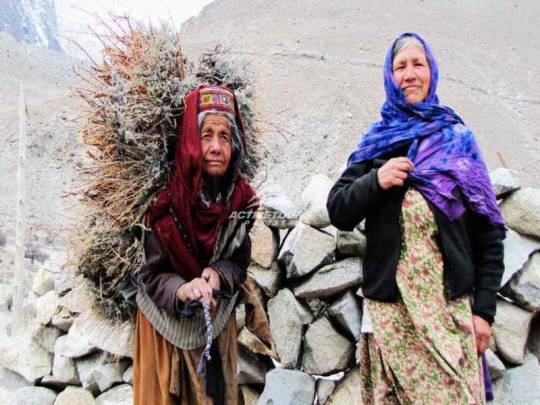
Children Of The Wakhan
Life in the Wakhan is rough, especially for kids. About 60% of children here die before the age of five, the highest infant mortality rate in the world. If they do survive, they are put to work helping out with the family business — animal herding.
There are a few schools out here, thanks to the Central Asia Institute, but it’s up to the parents if they go. In some communities, only the boys are sent to school. The morning commute can take a few hours by donkey due to the lack of roads and distance between settlements.
Central Asian Bactrian Camel
Wildlife In Afghanistan
I was really hoping to see a snow leopard or Marco Polo sheep while I was traveling through the mountains of Afghanistan’s Wakhan Corridor. You know, Walter Mitty style! Unfortunately both of these endangered animals are extremely difficult to spot — but I did find camels!
Luckily the Wildlife Conservation Society has staff in the area, often spending weeks in the field gathering data to protect wildlife in the Wakhan. They estimate there are about 100-200 snow leopards living in these mountains. Wolves and bears also call this wilderness home.
The Country You Thought You Knew…
The Other Afghanistan
So there you go. A peek at the other side of Afghanistan that we never see on the nightly news. After traveling the world extensively for the past 6 years, I’ve noticed this is a common theme.
Don’t let our media, which is primarily focused on negative & sensational topics, be your only window into the dynamics of a foreign country you’ve never been to.
I’m not going to tell you that Afghanistan is safe. It’s not. Our troops who’ve served there can tell you. Afghans themselves are well aware of the dangers that plague their country too.
But I think there’s another side to Afghanistan that deserves some attention. The rugged, scenic mountain landscapes. The friendly, hospitable local people.
I’m hopeful for the day when Afghanistan’s problems fade away, and more travelers can safely enjoy the beauty this incredible country has to offer. ★
Bonus Video! Backpacking Afghanistan
Subscribe to my YouTube Channel for new Adventure Travel Videos!
(Click to watch Backpacking Afghanistan – Wakhan Corridor on YouTube)
Pin This On Pinterest:
READ MORE FROM AFGHANISTAN
How To Visit The Wakhan Corridor
Have any questions about Afghanistan? What do you think? Drop me a message in the comments below!
This is a post from The Expert Vagabond adventure blog.
0 notes
Photo
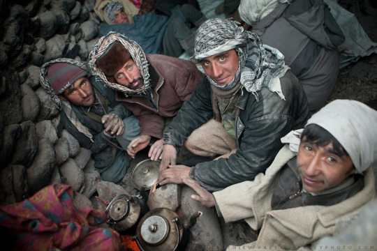
Wakhi men warming themselves around a fire... Trekking up to the Little Pamir with yak caravan over the frozen Wakhan river.
34 notes
·
View notes
Note
Hey the guy from GB here I'm really glad u answered my question it was my first time seeing this forum. And yeah I'll be very happy to help to know about GB better. The only thing I can tell u right now is that GB is hella diverse and really influenced by Persian and Tibet culture the people from skardu and baltistan have mostly Asian eyes and language and culture is very similar to the peoples at tibet
-!!!! I look forward to you teaching me more about your culture and province!! :DD ahhhh this is so exciting. You can message me on tumblr directly and i’ll respond ^^
I see :0 I thought Gilgit Baltistan had central asian influence because of Xinjiang etc etc but your explanation makes sense too as the neighboring Tajiks and Wakhis also belong to the Iranic group. I can see why Baltistan is called “Little Tibet” though XD GB is indeed hella diverse because you have the dardics, baltistanis, gilgitis, Hunzais i.e Burushos, then you have the migrants from other areas like the Uyghurs, Tajiks , Wakhis etc etc. From what i know, the Hazaras also have that same mongoloid look, and their origin seems to stem from Karlugh Turks (Though they reside in the Hazara region of KPK, but they also look like mongoloid people.) Interesting interesting. Pakistan truly is a melting pot of so many cultures and people heh.
To be honest, when i first looked at the cultural attire of Baltistan (female), I wanted to make the representative of Baltistan female too, but then again the men’s robes are also equally adorable hahaha But sometimes i get confused because the clothes shown as “Gilgit Baltistani” also come off of as “Hazara” clothing and etc etc. Sometimes Kalash clothing is added into the mix too. Long story short, this all makes my brain short circuit and explode (=___=) As i’m sure yours must’ve done too while reading all of this. I am just so..so confused.
At first glance, you’d think Pakistan is divided along provincial cultural grounds. But if you look a little closer, you’ll realize that the provinces themselves have further cultural differences in themselves too. Look a little closer , you’ll find more divisions with people having origins from god knows where. This makes sense because this region as a whole has seen so many invasions and infighting x’D Making Pakistan’s character has been hell because i’m never too sure if i am portraying this diversity right or not. And, i’ve let my thoughts ponder on for too long-
Thanks for Asking!!
#ask-pakistan#aph pakistan#regions of pakistan#Gilgit Baltistan#Cultures of Pakistan#Answered ask#Thanks for asking!!#I am going to set his tone for medium#i don't want to create two different versions of Pakistan because i don't want to divide him xD#Also it doesn't helps that both Indic and Iranic versions of Pakistan would essentially bleed into one another#Because Punjab for example has many diaspora from other provinces#who have settled here for generations#so we have Kashmiri Punjabis in the north#Pashtun Punjabis in the west#Balochi Punjabis in the South West#Sindhi Punjabis and Saraikis in the South#Sindh i think tries to keep its homogenousness#but they are pretty close with the Balochis#Actually Balochis and Sindhis allow their provinces to bleed into one another#and so the similarities between them ensue too#And then again i want to make Pakistan relatable for myself too#because i think i know what true Pakistaniat is#and what the common Pakistani culture should be#This is why i largely try to keep a hold on my own Punjabi heritage (questionable as this varies too)#because i don't want to over power the other aspects of Pakistan#Which i think a lot of foreign observers too#And that personally irks me because i don't want the main representation of Pakistan be alienating for the people in other regions when#Punjabis are just barely 50%#and these punjabis themselves are very divided as i've told you above#Punjabis aren't a homogenous group
26 notes
·
View notes
Text
A guide for traveling Tajikistan (Tips + 3-week itinerary)
The ex-Soviet Republic of Tajikistan is a truly wild country that you don’t want to miss in your Silk Road journey.
Home to the Pamir range, one of highest mountain ranges in the world, the mountains of Tajikistan attract the most adventurous travelers, especially those wanting to drive the M-41, or Pamir Highway, an impressive road and architectural masterpiece that goes through some of the remotest and most beautiful mountain scenery in Central Asia.
With tourism increasing year by year, the country is daily becoming more prepared to receive international travelers and, after spending 1 month in the country, I have this compiled this guide that contains all the tips needed for traveling to Tajikistan, plus a compelling 3-week itinerary.
Read: Ultimate guide to the Pamir Highway
Visa
Travel Insurance
Best time to visit
The country, the people and its culture
Getting in
Safety
Scams and corruption
Money
Food and alcohol
Transportation
Useful books
Internet and SIM Card
Accommodation
Itinerary
More information
Total transparency! – If you like my website and found this post useful, remember that, if you buy any service through of my links, I will get a small commission at no extra cost to you. These earnings help me maintain and keep Against the Compass going! Thanks
Do you know what a VPN is? A Virtual Private Network allows you to access blocked sites when you travel, as well as it lets you access content only available in your home country (like Netflix), plus it prevents hackers from stealing your personal data. Learn here why you should always use a VPN when you travel
How to get a visa for visiting Tajikistan
Most likely, you can get an e-visa – Most nationalities can apply for an e-visa through the official portal, valid for any port of entry.
The visa costs 50USD, is valid for 45 days, single entry and takes 1 or 2 working days.
Double entry visa – If you want one, you will have to get it through the embassy. Most people who want a double entry visa do so because they want to travel the Afghan Corridor, accessible from Ishkashim.
If this is your case, these are the requirements:
1 Passport valid for at least 6 months of validity and with two empty pages
Passport copy and visa copy from the country you are applying from
2 Passport photos
US Dollars
I applied for one in Bishkek, Kyrgyzstan, and got it on the same day.
My double entry visa for visiting Tajikistan
GBAO Permit – The Gorno-Badakhshan Autonomous Region (GBAO) is the region located in the east of Tajikistan, where the Pamir Highway and Wakhan Valley are.
If you want to visit it, you must tick the GBAO checkbox in the application form. If you are applying at the embassy, make sure to tell them, so you get the extra stamp.
By the way, the GBAO permit costs an additional 20USD.
Read: 30 Tips for traveling to Kazakhstan
Trekking in GBAO – Things to do in Tajikistan
Travel Insurance for Tajikistan
Eastern Tajikistan, where the Pamir Highway is, is a high altitude area, averaging around 4,000 meters above sea level.
You should know that, if you read the fine print, most insurance companies won’t cover you from 2500-3,000m and above, so you better check before you travel to Tajikistan.
World Nomads, however, does provide cover, including their most basic policy, which already covers for trekking at 4,000m.
CLICK HERE TO GET YOUR FREE QUOTE FROM WORLD NOMADS
If you want to know more options, read how to find the best backpacking insurance
Best time to visit Tajikistan
If you plan to do some trekking in eastern Tajikistan, you should come in summer.
I remember being in Alichur, a small village in the Pamir Highway and one of the coldest places in Central Asia, and, in the morning, during August, it was -5ºC and there was a freezing, strong wind, so it felt even colder.
Imagine the weather there during the rest of the year.
Me, at the top of Gumbezkul Pass. It was the month of August and it was absolutely freezing – Best things to do in Tajikistan
Nevertheless, the Pamir Highway is open all year long so, if you are self-driving, you can drive it at any time. Actually, my friend Joao Leitao from Nomad Revelations drove it in winter.
On the other hand, the Fann Mountains in west Tajikistan are at lower altitude, hence warmer, so they can be visited during spring and fall.
I did the 7 lakes trek in September and it was particularly hot!
The Fann Mountains – Is travel to Tajikistan safe
The country, the people and its culture
After the Soviet Union’s dissolution in 1991, Tajikistan went through a dark period of Civil War that lasted pretty much until 1997 and it was not only in 1999, that they formed an actual, stable government, even though Emomali Rahmon, who is still today President of Tajikistan today, had already been ruling from 1994.
It was one of the countries most affected by the Soviet Union’s breakdown, as all their economy and development depended on the Russians so, after getting their independence, the country went to ruin.
Murghab and all the Pamir highway is really poor – Should I travel to Tajikistan
That crisis can still be seen today, as this is clearly the least developed of all the Stans (not counting Turkmenistan), a country with high rates of unemployment, and the fact that most of their infrastructure is still from the Soviet Union times.
It is also the least Westernized country, also due to the fact they are far from Russia so, unlike Kyrgyzstan and Kazakhstan, their cultural influence is not that visible, hence they have less international exposure.
Actually, after having some conversations with quite a few highly educated Tajiks in Dushanbe, I felt that they don’t really know anything about what is going on in the outside world.
A Soviet truck
They were people with very few Western values and no apparent ambition who asked me many times why I would ever want to travel to Tajikistan.
Moreover, Tajikistan is one of those fake democracies where elections are celebrated but there is only one political party, so the same President has been ruling since 1994.
There is no freedom of speech and I remember when my Australian friend, Sam, was talking to a local man for about half an hour at the main square in Dushanbe, a man in a suit came to ask what was going on and invited him to leave.
This means that, still today, the Government doesn’t like their citizens to get international exposure.
The Tajiks – Tajiks are a Persian ethnic group who live mainly in Tajikistan and Afghanistan, but also in Xinjiang (China) and Uzbekistan.
Actually, nearly half of the total Tajik population live in Afghanistan.
Lovely Tajiks in Khujand – tRAVEL TO tAJIKISTAN
Nevertheless, you should know that, like all the Stans, Tajikistan is ethnically mixed and, actually, most of the people living in the Pamirs are Kyrgyz, whereas those in the Wakhan Valley are Wakhis, so if you want to meet the real Tajiks when you are traveling to Tajikistan, you will have to explore Dushanbe and the western part of the country.
Kyrgyz people from the Pamirs
Language – Tajik, which is a dialect of Persian (the language spoken in Iran and Afghanistan) is the official language. Russian is, of course, widely spoken among most people. English tends to be a problem across all the country. I recommend you learn some basic Russian before you visit Tajikistan.
Religion – Tajiks are Suni Muslims but, like in all Central Asia, religion is not a very big deal. However, I felt that Tajiks were the most religious people in all Central Asia, especially those from the Fann Mountains. I remember that the men there never said hello or shook hands with my girlfriend.
Read: 65 Tips for traveling to Uzbekistan
Tajik women – Tajikistan travel guide
How to travel to Tajikistan
Travel to Tajikistan by air
Traveling to Tajikistan by air is very easy, as there are many international flights connecting Dushanbe with Europe.
If you intend to travel the Pamir Highway, many people fly into Osh, the largest city in southern Kyrgyzstan and the beginning of the M-41 on the Kyrgyz side.
Travel to Tajikistan by land
Moreover, if you want to travel to Tajikistan by land, know that it shares a border with 4 countries and most of them have multiple border crossings.
Kyrgyzstan – There are 6 border crossings and 4 of them are open to foreigners. The most obvious is the Kyzyl Art border crossing, which is the one that follows the Pamir Highway. For more information, read the latest Caravanistan updates.
Kyzyl Art pass: Tajikistan-Kyrgyzstan border – Tajikistan travel guide
Uzbekistan – There are 5 border crossings with Uzbekistan and all of them seem to be open. I personally crossed the one at Konibodom, that links Khujand with the Fergana Valley, but if you don’t plan to visit that region, it is not very convenient. The Oybek border crossing is the one that connects Khujand with Tashkent and Penjakent is the one that connects the Fann Mountains with Samarkand. For more information, check the latest updates on Caravanistan.
Afghanistan – You can cross at Ishkashim, the gate to the Wakhan Corridor and a very safe part of Afghanistan; or the border crossing south of Dushanbe, which is also open but leads to Kunduz, a not very safe part of Afghanistan. Both borders are open but, if you plan to travel back to Tajikistan, remember to have a double entry visa.
China – Apparently, Kulma Pass is open now, as long as you have a valid printed visa on your passport. For more information, check the latest updates on Caravanistan.
Kulma Pass leads directly to the Karakoram Highway that connects Kashgar with Islamabad in Pakistan. Read here the full guide.
Read: 75 Tips for traveling to Kyrgyzstan
Uzbekistan – Tajikistan border crossing
Is it safe to travel to Tajikistan?
In summer 2018, 4 cyclists traveling across Tajikistan were murdered in Danghara, an area relatively close to Dushanbe. ISIS claimed the attack.
That accident triggered a big concern among many travelers and the Tajiks are concerned that it might affect their tourism negatively.
This unfortunate event, however, has been a one-off thing and I personally think that it shouldn’t affect your decision to travel to Tajikistan. A similar case happened in Morocco in December 2018 when 2 Scandinavian girls were killed and, so far, it doesn’t seem that tourism has been affected.
Aside from that, Tajikistan is a safe country with very low crime rates.
Tajiks are always friendly – Is traveling to Tajikistan safe
Scams and corruption when visiting Tajikistan
I still remember being in the car with a homestay owner, on our way to Khujand, when he gave some money to a policeman after stopping at one checkpoint.
Why did you give him money? – I said
Oh, this is just the standard bribing procedure. If we don’t pay him, then he would try to find a reason to fine or arrest us.
The corruption in Tajikistan is a well-known fact and some of these police officers also try to rip off foreigners but luckily, as tourists, there is not much they can do to you unless you are credulous and believe their lies.
Common scams include policemen telling you that there is a problem with your Tajik visa or making you pay an entrance fee to a place that, obviously, doesn’t require an entrance fee.
Dude, just think:
How the hell there is going to be something wrong with your visa?
And also,where have you been where you need to purchase an entry ticket from a policeman?
Just say no and continue with your business.
Epic landscapes
Money when you travel in Tajikistan
The official currency is the Tajik Somoni and, in February 2019, 1USD = 9.50SOM
ATMs and credit cards – You can find ATM’s in the big cities (not in the Pamir Highway).
How much does it cost to travel to Tajikistan
It really depends on where you go and, ultimately, how you travel the Pamir Highway.
Typically, meals cost something between 1 and 3USD and budget homestays around 10-15USD, which tends to include dinner and breakfast.
In Dushanbe, you can find dorms for 3-4USD and the local transportation ranges from 2 to 10USD, depending on where you go.
For all costs referred to the Pamir Highway, read my guide.
Read: 80 Tips for traveling to Iran
We were on a low budget, so we hitchhiked the entire Pamir Highway
Food and alcohol when visiting Tajikistan.
Heads-up.
Like in all Central Asia, the food won’t be the highlight of your visit in Tajikistan.
In the Pamirs and different homestays, you are likely to eat shorpo for every meal, which is a meat broth.
In local restaurants, you will just find things like shahslik, meat skewers; lagman, a noodle soup; manti, fatty meat dumplings; or plov, rice fried in lamb fat.
As per alcohol, as in all ex-Soviet countries, beer and especially vodka are found everywhere.
Lagman is the comodin dish. After eating 100 bowls of it across all Central Asia, I really hated it but since I like pasta a lot, I could handle it more than other dishes
Transportation when you travel around Tajikistan
The below information refers to types of transportation in western Tajikistan, not the Pamir Highway. For this, read my guide to the Pamir Highway.
Marshrutkas – Marshrutkas is what former Soviet countries call their public minivans. They are really cheap and travel between most towns and cities.
Local shared taxis – Actually, we used more local shared taxis than marshrutkas and, as far as I could see, they are the most preferred option among locals.
Hitchhiking – Highly doable and easy! We actually had one of our most crazy hitchhiking experiences, when we spent more than 48 hours in a truck, on our way from Khorog to Dushanbe.
Traveling in a mini UAZ-452 – A classic Soviet van
Books for traveling to Tajikistan
Tajikistan Travel Guide by Bradt – The most comprehensive travel guide to Tajikistan. I bought all the Bradt guides to Central Asia (e-Book format). They are, by far, the most insightful guides I have ever read recently.
CLICK HERE TO CHECK PRICES ON AMAZON
Central Asia Travel Guide by Lonely Planet – I am not a fan of this guide, but if you are traveling to all the Stans and want to buy just one book, it is a good choice as well.
CLICK HERE TO CHECK PRICES ON AMAZON
Internet and mobile when traveling in Tajikistan
Wi-Fi – From Murghab to Khujand and Dushanbe, the Wi-Fi connection when you are traveling in Tajikistan is one of the worst I have ever seen. In Dushanbe, the Wi-Fi in my hostel was particularly bad and then every day I would go work to a fancy café and the internet was down every now and then. In the Pamir Highway and the Wakhan Valley, Wi-Fi doesn’t exist.
SIM Card – 3G was just OK anywhere outside of the Pamir Highway. I bought MegaFon and, for a few Somonis, I got plenty of GBs.
Accommodation in Tajikistan
Homestays – On the Pamir Highway, homestays are the way to go. I recommend you stay in random homestays, not in the popular ones. This way, the benefits will be spread more equally plus random homestays are cheaper.
Hostels – Hostels are popular, from Khorog to Dushanbe and Khujand. Click here to check all the available hostels in Tajikistan!
Hotels – In Khorog, Dushanbe, and Khujand you can find hotel options for mid-range travelers. Click here to check all the available hotels in Tajikistan!
Yurts – In the Pamirs, you can also find nomadic yurt camps where Kyrgyz nomads live.
A yurt camp somewhere in the Tajik Pamirs
Traveling to Tajikistan – 3-week Itinerary
I traveled to Tajikistan from Kyrgyzstan via Kyzyl Art Pass and left through Uzbekistan at Konibodom, so this Tajikistan itinerary reflects the direction I took.
Map of the Tajikistan itinerary
Things to do in Tajikistan – Pamir Highway (8-9 days)
Built by the Soviets in 1930, the Pamir Highway is an architectural masterpiece that goes through some of the remotest landscapes you can ever imagine.
Officially, it starts in Osh (Kyrgyzstan) and ends in Afghanistan but the highest and most beautiful part of it lies in Tajikistan.
The following information is just a small summary.
For the full guide, read my 6,000-word guide to the Pamir Highway.
The stunning Pamir Highway – Tajikistan travel itinerary
How many days are needed for the Pamir Highway?
Well, it is really hard to say. We spent more than 2 weeks between the Pamir Highway and the Wakhan Valley but that is because we stopped in many places plus we also did a 3-day trek.
Normally, most people take a 5 or 7-day tour (starting from Osh), which also includes the Wakhan Valley, but, to be very honest, it is not enough to explore the side valleys, which is where the most stunning landscapes are.
Amazing road! – Tajikistan travel itinerary
If you don’t have the time, I get it but, if you do, here are all the places you need to stop at:
Karakul (1 night) – The first big settlement coming from Kyrgyzstan, Karakul has a very big lake and with some pretty cool snow-capped mountains at the background.
Murghab (2-3 nights) – Murghab is the main town on the M-41 and a base for visiting other places and valleys. We first stayed 2 nights because we waited for a festival and then we stayed a 3rd night after coming back from the trek.
The mosque in Murghab – Tajikistan itinerary
Gumbezkul Pass trek (2-3 nights) – If you have your own car, you can do this trek in 1 day but we did it in 3, cause we walked all the way from Murghab and spent one amazing night with some real nomads in the middle of nowhere. For more information, I wrote the full guide for Everything Everywhere: How to trek the Gumbezkul Pass.
Alichur (1 night) – Very cool landscapes, yaks, trekking and Marco Polo sheep safaris.
Madyian Valley, close to Murghab – things to do in Tajikistan
Bulunkul (Stopover) – The coldest place in Central Asia is home to a beautiful lake. The trek from Alichur to here is a popular one. You can find a few homestays.
For most travelers, the Pamir Highway is, definitely, one of the best things to do in Tajikistan.
For more information, don’t forget to check my guide to the Pamir Highway
The festival we attended in Murghab – Things to do in Tajikistan
Places to visit in Tajikistan – Wakhan Valley (3-4 days)
Many travelers tend to classify the Wakhan Valley as part of the Pamir Highway (M-41), which is completely wrong because they are 2 different places.
Actually, to reach the Wakhan Valley you need to leave the road and drive towards Afghanistan for several kilometers.
The Wakhan Valley
Anyways. The Wakhan Valley is one of my most favorite places in entire Central Asia and my most favorite place in my Tajikistan itinerary.
And the reason is that, besides being home to intriguing and jaw-dropping landscapes, the Wakhan is of great historical importance as the ancient border between North Asia and South Asia and on the remarkable Silk Road route, which can be seen in the many fortresses and other sites of cultural heritage there.
Moreover, in the 20th century, the Wakhan Valley marked the border between the Soviet Union and Afghanistan and the Soviet tanks came through here to invade Afghanistan in the 70s.
Today, the river you will go along during your whole journey, whose other side is in Afghanistan, is the main entry point for smuggling products, especially heroin, and, from the window of your car, you can wave and say hello at the many Afghans across the river, from whom you are separated by only a couple of meters.
Once again, this is a small summary, so for more information, don’t forget to check my guide to the Wakhan Valley in Tajikistan.
The views from Khaaka fortress – Left side is Afghanistan and right Tajikistan – Places to visit in Tajikistan
These are all the places we stopped at:
Langar (1 night) – The first big settlement you find is Langar.
We personally didn’t like Langar, as it is the only place in the Wakhan where the locals are very pushy in trying to promote their homestays, plus it is actually far from the river.
I recommend you continue for a few kilometers to Hisor, a more genuine village and with nicer views to actual Afghanistan.
Vrang (stop) – Vrang is another old village that has an ancient Buddhist temple. It is worth stopping for a few hours.
Yamchun (1 night) – The most striking fortress in the Wakhan, which stands with the Afghan Hindu Kush on its background.
Yamchun fortress – Places to visit in Tajikistan
It also has some famous hot springs called Baby Fatima that are believed to have some fertility benefits.
Namadgut (1 night) – There is nothing in particular to see here but travelers don’t tend to stop here, so it is quite untouched. That is why here we had the best cultural experience with a local woman who blessed us with her hospitality.
Kaakha Fortress – The second most famous fortress after Yamchun has also great views to Afghanistan.
Ishkashim (1 night) – The main town in the Wakhan Valley. It used to hold the Afghan market in no man’s land but it is temporarily closed. It is also the border to Afghanistan for those interested in doing the Afghan Wakhan corridor.
For more information, read my guide to the Wakhan Valley
Wakhi people – Best things to do in Tajikistan
Tajikistan itinerary – Khorog (2 days)
After nearly two weeks of showering with buckets, using holes and bushes as toilets, exclusively eating shorpo and with no internet at all, getting to Khorog felt particularly good.
It is not a very big town but it has a good local market where you can buy many food items that were not available in the Pamir Highway, like cheese, and supermarkets with cold beer.
There is also an Indian restaurant that tends to be filled with travelers and a really good Tajik restaurant by the river, serving high quality grilled meat and other stuff.
Other than this, Khorog is a place to just chill, where we spent 4 days just catching up with work and filling our bellies with decent food.
By the way, the famous Afghan market takes place on Saturday.
Afghan people in the Afghan market of Khorog – A travel guide to Tajikistan
Where to stay in Khorog
Backpacker Hostel – Pamir Lodge – All right, it is a cool place and there is a friendly atmosphere. However, the hostel has the capacity for nearly 100 people and it only has two toilets and two showers, so when I came in August, it was very difficult to find them empty, apart from being quite dirty of course.
Backpacker Hostel – Hostel Do Nazarbayg – An alternative to Pamir lodge. You will find fewer backpackers but the location is much better and it is not that busy.
Click here to see the latest prices
Guest House – Riverside – A quieter, more homestay-style place.
Click here to see the latest prices
The journey to Dushanbe – 1 day
The road to Dushanbe is a very long way.
Shared taxis take around 12 hours and cost 30USD. They leave from near the market but you need to be there early, 7am at most.
We arrived before 8am and there weren’t any marshrutkas or taxis left, so we decided to hitchhike and it took us 3 days, spending more than 48 hours in a truck.
The distance is only 518km but the road is really bad but beautiful and interesting as, again, it goes along the Afghan border for the most part of it.
The road from Dushanbe to Khorog: the left side is Afghanistan and the right Tajikistan
Things to do in Tajikistan – Dushanbe (2 days)
The capital of Tajikistan is another place to chill for a few days while you collect some visas, like the Uzbek or Turkmen visas.
Well, not the Uzbek visa anymore, as from February 2019, they started issuing visas on arrival. Check my Uzbekistan travel guide for more information.
Dushanbe has cafés with real coffee, a variety of restaurants and a few pubs where to hang out at night.
What I liked about Dushanbe is that it was my first introduction to the real Tajikistan, as most people you meet in the eastern part are Kyrgyz, Wakhis or Pamir, so you will see a significant difference with the people living here, especially in the way women dress.
Don’t forget to check the main bazaar and the Rudaki Park, which holds the second tallest flagpole in the world
Where to stay in Dushanbe
Backpacker Hostel – Green House Hostel– We spent so many days here because the hostel was really comfortable. Comfy beds, a big kitchen and a living room with awesome couches.
Click here to see the latest prices
Budget Guest House – Hello Dushanbe – If you want a less backpacker-friendly place, Hello Dushanbe may be slightly more expensive but the facilities are great. It has both private rooms and a dorm.
Click here to see the latest prices
Lovely Tajik women
Hissor Fortress – Day trip from Dushanbe
If you are bored to be in Dushanbe, we also did a day trip to a fortress named Hissor, which was built by the Uzbeks in the 18th century, as this part of Tajikistan used to belong to the Emirate of Bukhara. The north was part of the Russian empire.
All right, the fortress itself was boring, as it was overly refurbished, but we always like to get out of town, take a local marshrutka and just see other towns, so it was worth it only for this reason.
How to get to Hissor fortress
From Dushanbe, you need to take a marshrutka to a town named Khisor. From there, take a taxi or hitchhike back to the fortress which is 4 or 5km away.
The fortress
Places to visit in Tajikistan – Penjakent and the Fann Mountains (3-4 days)
Once again, this is a small summary.
For all the information needed, read my guide to the Fann Mountains.
While they are not as stunning as the valleys around the Pamir Highway, the Fann Mountains are also very pretty and their main advantage is that, unlike the Pamirs, they are heavily populated and filled with several tiny villages where actual Tajik people live.
Tajiks from the Fanns
Therefore, visiting the Fann Mountains is a great opportunity to discover the real Tajik rural life, so different from anything you have seen during your Tajikistan itinerary.
Most people come to the Fann Mountains to visit Iskanderkul lake but I recommend going to the area around Penjakent and doing the 7 Lakes Trek.
Trekking in the Fanns
The reason is that, although Iskanderkul is a beautiful lake, no people live there plus it is always busy with domestic tourists, which isn’t a bad thing, but you won’t see much of the local culture.
On the other hand, the 7 Lakes trek starts in Penjakent and goes through several tiny villages where you can do homestays.
From Penjakent, we took a UAZ-452, the classic Soviet mini-van, and drove to a village named Rachnapollon.
That area is really off the beaten track, so the driver himself invited us to stay at his place, for free, but we decided to give him a generous tip because he had been feeding us.
How to get to Penjakent
First, take a local shared taxi from Dushanbe to Penjakent, which costs 70TJS (8USD). It is a 230km journey.
In Penjakent, for just a few somonis, we got in the UAZ-452 to Rachnapollon, from where we started walking on the next day.
Remember to check my guide to the Fann Mountains
Random people during the trek
Places to visit in Tajikistan – Khujand (2-3 days)
Khujand is the purest Tajikistan in its most genuine form and one of the oldest cities in Central Asia (2,500 years old).
It is the second largest city in the country, a city with little international exposure that has kept its traditional values.
Most travelers use it as a mere transit point, as it is close to the closest border with Tashkent, but I recommend spending here two nights at least.
Arbob Palace Tajikistan
Things to do in Khujand
Don’t forget to check the traditional bazaar, one of those traditional bazaars where everybody asks for a photo and gives you free stuff; and all the mausoleums and historical buildings around the main square. The Arbob Palace is also worth checking out.
Mosques in Khujand
Where to stay in Khujand
Budget Hostel – Somoni Hostel – The best choice for backpackers and a really cool hostel.
Click here to check the latest prices
Budget Hotel – Golden Apartments – The alternative to a backpacker hostel.
Click here to check the latest prices
Khujand’s bazaar
More information for visiting Tajikistan
Here you can find all my articles and travel guides to Tajikistan
And here all my guides to Kyrgyzstan, Uzbekistan, and Kazakhstan.
Traveling to Iran? Find all my articles here
from Cheapr Travels https://ift.tt/2WmI1Xa
via https://ift.tt/2NIqXKN
1 note
·
View note
Photo
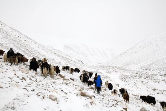
Moving Flocks. Early morning, on our way to the Little Pamir. 5th day walk. We brought the yack herd of our hosts out to the pastures. Wolves are less a threat for yaks and can be left for some while without surveillance. Herding necessitates however constant management, impossible to leave the camps fo a while. If Afghan Kyrgyz settled the Little Pamir, it is a greater issue for Wakhi who leave families for 6-8 months a year down in the lowlands. Small camps of men only from which curious jokes and stories abound. #Afghanistan #Pamirs #Wakhan #Solitude #Herd #Yak #walk #mountains #longdistancelove (at Vakhan, Afghanistan) https://www.instagram.com/p/B3rpEeJoP7Q/?igshid=znc4pdd1bw4i
1 note
·
View note
Photo

Strength Khaibu moved to the Pamirs with her husband after the war peaked in violence following Dr Najibullah’s death. Samaat was a soldier in the Afghan National Army, nostalgic of the relative stability he could enjoy earlier while patrolling in Faisabad where he met her. Because of more than acute threats, they returned to his home in the Little Pamir where he herds the animals of his distant cousins. She learnt Kyrgyz and adopted the way, dress and style to the point that she vehemently refuses to speak Dari, as many Wakhi women married to Kyrgyz men do. (at Vakhan, Afghanistan) https://www.instagram.com/p/CMMakRTBr01/?igshid=xcwo9dqrztxz
0 notes
Photo
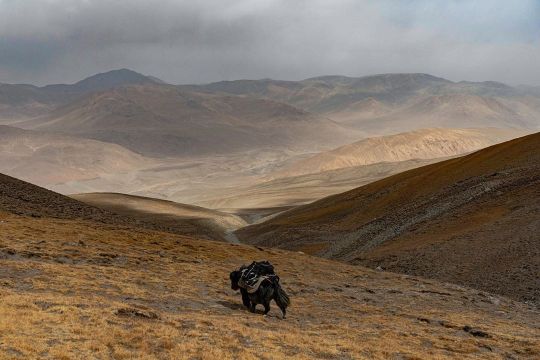
Vakhyt e Kuch. In Wakhi, time to leave summer camps, time to pack yurts and for families to return to the lowlands. Only a few men will remain upland for the cold months. Ahead Tajikistan, the road and the border run along the Panj river. Our yak traced his own path, rushing to the next camp. #Afghanistan #Wakhan #Pamir #yak #mountain #migration #season #time #fall #colors #photography #ethnography (at Vakhan, Afghanistan) https://www.instagram.com/p/CGEtDZHHopW/?igshid=159vy7ah0x9xs
0 notes
Text
A guide for traveling Tajikistan (Tips + 3-week itinerary)
The ex-Soviet Republic of Tajikistan is a truly wild country that you don’t want to miss in your Silk Road journey.
Home to the Pamir range, one of highest mountain ranges in the world, the mountains of Tajikistan attract the most adventurous travelers, especially those wanting to drive the M-41, or Pamir Highway, an impressive road and architectural masterpiece that goes through some of the remotest and most beautiful mountain scenery in Central Asia.
With tourism increasing year by year, the country is daily becoming more prepared to receive international travelers and, after spending 1 month in the country, I have this compiled this guide that contains all the tips needed for traveling to Tajikistan, plus a compelling 3-week itinerary.
Read: Ultimate guide to the Pamir Highway
Visa
Travel Insurance
Best time to visit
The country, the people and its culture
Getting in
Safety
Scams and corruption
Money
Food and alcohol
Transportation
Useful books
Internet and SIM Card
Accommodation
Itinerary
More information
Total transparency! – If you like my website and found this post useful, remember that, if you buy any service through of my links, I will get a small commission at no extra cost to you. These earnings help me maintain and keep Against the Compass going! Thanks
Do you know what a VPN is? A Virtual Private Network allows you to access blocked sites when you travel, as well as it lets you access content only available in your home country (like Netflix), plus it prevents hackers from stealing your personal data. Learn here why you should always use a VPN when you travel
How to get a visa for visiting Tajikistan
Most likely, you can get an e-visa – Most nationalities can apply for an e-visa through the official portal, valid for any port of entry.
The visa costs 50USD, is valid for 45 days, single entry and takes 1 or 2 working days.
Double entry visa – If you want one, you will have to get it through the embassy. Most people who want a double entry visa do so because they want to travel the Afghan Corridor, accessible from Ishkashim.
If this is your case, these are the requirements:
1 Passport valid for at least 6 months of validity and with two empty pages
Passport copy and visa copy from the country you are applying from
2 Passport photos
US Dollars
I applied for one in Bishkek, Kyrgyzstan, and got it on the same day.
My double entry visa for visiting Tajikistan
GBAO Permit – The Gorno-Badakhshan Autonomous Region (GBAO) is the region located in the east of Tajikistan, where the Pamir Highway and Wakhan Valley are.
If you want to visit it, you must tick the GBAO checkbox in the application form. If you are applying at the embassy, make sure to tell them, so you get the extra stamp.
By the way, the GBAO permit costs an additional 20USD.
Read: 30 Tips for traveling to Kazakhstan
Trekking in GBAO – Things to do in Tajikistan
Travel Insurance for Tajikistan
Eastern Tajikistan, where the Pamir Highway is, is a high altitude area, averaging around 4,000 meters above sea level.
You should know that, if you read the fine print, most insurance companies won’t cover you from 2500-3,000m and above, so you better check before you travel to Tajikistan.
World Nomads, however, does provide cover, including their most basic policy, which already covers for trekking at 4,000m.
CLICK HERE TO GET YOUR FREE QUOTE FROM WORLD NOMADS
If you want to know more options, read how to find the best backpacking insurance
Best time to visit Tajikistan
If you plan to do some trekking in eastern Tajikistan, you should come in summer.
I remember being in Alichur, a small village in the Pamir Highway and one of the coldest places in Central Asia, and, in the morning, during August, it was -5ºC and there was a freezing, strong wind, so it felt even colder.
Imagine the weather there during the rest of the year.
Me, at the top of Gumbezkul Pass. It was the month of August and it was absolutely freezing – Best things to do in Tajikistan
Nevertheless, the Pamir Highway is open all year long so, if you are self-driving, you can drive it at any time. Actually, my friend Joao Leitao from Nomad Revelations drove it in winter.
On the other hand, the Fann Mountains in west Tajikistan are at lower altitude, hence warmer, so they can be visited during spring and fall.
I did the 7 lakes trek in September and it was particularly hot!
The Fann Mountains – Is travel to Tajikistan safe
The country, the people and its culture
After the Soviet Union’s dissolution in 1991, Tajikistan went through a dark period of Civil War that lasted pretty much until 1997 and it was not only in 1999, that they formed an actual, stable government, even though Emomali Rahmon, who is still today President of Tajikistan today, had already been ruling from 1994.
It was one of the countries most affected by the Soviet Union’s breakdown, as all their economy and development depended on the Russians so, after getting their independence, the country went to ruin.
Murghab and all the Pamir highway is really poor – Should I travel to Tajikistan
That crisis can still be seen today, as this is clearly the least developed of all the Stans (not counting Turkmenistan), a country with high rates of unemployment, and the fact that most of their infrastructure is still from the Soviet Union times.
It is also the least Westernized country, also due to the fact they are far from Russia so, unlike Kyrgyzstan and Kazakhstan, their cultural influence is not that visible, hence they have less international exposure.
Actually, after having some conversations with quite a few highly educated Tajiks in Dushanbe, I felt that they don’t really know anything about what is going on in the outside world.
A Soviet truck
They were people with very few Western values and no apparent ambition who asked me many times why I would ever want to travel to Tajikistan.
Moreover, Tajikistan is one of those fake democracies where elections are celebrated but there is only one political party, so the same President has been ruling since 1994.
There is no freedom of speech and I remember when my Australian friend, Sam, was talking to a local man for about half an hour at the main square in Dushanbe, a man in a suit came to ask what was going on and invited him to leave.
This means that, still today, the Government doesn’t like their citizens to get international exposure.
The Tajiks – Tajiks are a Persian ethnic group who live mainly in Tajikistan and Afghanistan, but also in Xinjiang (China) and Uzbekistan.
Actually, nearly half of the total Tajik population live in Afghanistan.
Lovely Tajiks in Khujand – tRAVEL TO tAJIKISTAN
Nevertheless, you should know that, like all the Stans, Tajikistan is ethnically mixed and, actually, most of the people living in the Pamirs are Kyrgyz, whereas those in the Wakhan Valley are Wakhis, so if you want to meet the real Tajiks when you are traveling to Tajikistan, you will have to explore Dushanbe and the western part of the country.
Kyrgyz people from the Pamirs
Language – Tajik, which is a dialect of Persian (the language spoken in Iran and Afghanistan) is the official language. Russian is, of course, widely spoken among most people. English tends to be a problem across all the country. I recommend you learn some basic Russian before you visit Tajikistan.
Religion – Tajiks are Suni Muslims but, like in all Central Asia, religion is not a very big deal. However, I felt that Tajiks were the most religious people in all Central Asia, especially those from the Fann Mountains. I remember that the men there never said hello or shook hands with my girlfriend.
Read: 65 Tips for traveling to Uzbekistan
Tajik women – Tajikistan travel guide
How to travel to Tajikistan
Travel to Tajikistan by air
Traveling to Tajikistan by air is very easy, as there are many international flights connecting Dushanbe with Europe.
If you intend to travel the Pamir Highway, many people fly into Osh, the largest city in southern Kyrgyzstan and the beginning of the M-41 on the Kyrgyz side.
Travel to Tajikistan by land
Moreover, if you want to travel to Tajikistan by land, know that it shares a border with 4 countries and most of them have multiple border crossings.
Kyrgyzstan – There are 6 border crossings and 4 of them are open to foreigners. The most obvious is the Kyzyl Art border crossing, which is the one that follows the Pamir Highway. For more information, read the latest Caravanistan updates.
Kyzyl Art pass: Tajikistan-Kyrgyzstan border – Tajikistan travel guide
Uzbekistan – There are 5 border crossings with Uzbekistan and all of them seem to be open. I personally crossed the one at Konibodom, that links Khujand with the Fergana Valley, but if you don’t plan to visit that region, it is not very convenient. The Oybek border crossing is the one that connects Khujand with Tashkent and Penjakent is the one that connects the Fann Mountains with Samarkand. For more information, check the latest updates on Caravanistan.
Afghanistan – You can cross at Ishkashim, the gate to the Wakhan Corridor and a very safe part of Afghanistan; or the border crossing south of Dushanbe, which is also open but leads to Kunduz, a not very safe part of Afghanistan. Both borders are open but, if you plan to travel back to Tajikistan, remember to have a double entry visa.
China – Apparently, Kulma Pass is open now, as long as you have a valid printed visa on your passport. For more information, check the latest updates on Caravanistan.
Kulma Pass leads directly to the Karakoram Highway that connects Kashgar with Islamabad in Pakistan. Read here the full guide.
Read: 75 Tips for traveling to Kyrgyzstan
Uzbekistan – Tajikistan border crossing
Is it safe to travel to Tajikistan?
In summer 2018, 4 cyclists traveling across Tajikistan were murdered in Danghara, an area relatively close to Dushanbe. ISIS claimed the attack.
That accident triggered a big concern among many travelers and the Tajiks are concerned that it might affect their tourism negatively.
This unfortunate event, however, has been a one-off thing and I personally think that it shouldn’t affect your decision to travel to Tajikistan. A similar case happened in Morocco in December 2018 when 2 Scandinavian girls were killed and, so far, it doesn’t seem that tourism has been affected.
Aside from that, Tajikistan is a safe country with very low crime rates.
Tajiks are always friendly – Is traveling to Tajikistan safe
Scams and corruption when visiting Tajikistan
I still remember being in the car with a homestay owner, on our way to Khujand, when he gave some money to a policeman after stopping at one checkpoint.
Why did you give him money? – I said
Oh, this is just the standard bribing procedure. If we don’t pay him, then he would try to find a reason to fine or arrest us.
The corruption in Tajikistan is a well-known fact and some of these police officers also try to rip off foreigners but luckily, as tourists, there is not much they can do to you unless you are credulous and believe their lies.
Common scams include policemen telling you that there is a problem with your Tajik visa or making you pay an entrance fee to a place that, obviously, doesn’t require an entrance fee.
Dude, just think:
How the hell there is going to be something wrong with your visa?
And also,where have you been where you need to purchase an entry ticket from a policeman?
Just say no and continue with your business.
Epic landscapes
Money when you travel in Tajikistan
The official currency is the Tajik Somoni and, in February 2019, 1USD = 9.50SOM
ATMs and credit cards – You can find ATM’s in the big cities (not in the Pamir Highway).
How much does it cost to travel to Tajikistan
It really depends on where you go and, ultimately, how you travel the Pamir Highway.
Typically, meals cost something between 1 and 3USD and budget homestays around 10-15USD, which tends to include dinner and breakfast.
In Dushanbe, you can find dorms for 3-4USD and the local transportation ranges from 2 to 10USD, depending on where you go.
For all costs referred to the Pamir Highway, read my guide.
Read: 80 Tips for traveling to Iran
We were on a low budget, so we hitchhiked the entire Pamir Highway
Food and alcohol when visiting Tajikistan.
Heads-up.
Like in all Central Asia, the food won’t be the highlight of your visit in Tajikistan.
In the Pamirs and different homestays, you are likely to eat shorpo for every meal, which is a meat broth.
In local restaurants, you will just find things like shahslik, meat skewers; lagman, a noodle soup; manti, fatty meat dumplings; or plov, rice fried in lamb fat.
As per alcohol, as in all ex-Soviet countries, beer and especially vodka are found everywhere.
Lagman is the comodin dish. After eating 100 bowls of it across all Central Asia, I really hated it but since I like pasta a lot, I could handle it more than other dishes
Transportation when you travel around Tajikistan
The below information refers to types of transportation in western Tajikistan, not the Pamir Highway. For this, read my guide to the Pamir Highway.
Marshrutkas – Marshrutkas is what former Soviet countries call their public minivans. They are really cheap and travel between most towns and cities.
Local shared taxis – Actually, we used more local shared taxis than marshrutkas and, as far as I could see, they are the most preferred option among locals.
Hitchhiking – Highly doable and easy! We actually had one of our most crazy hitchhiking experiences, when we spent more than 48 hours in a truck, on our way from Khorog to Dushanbe.
Traveling in a mini UAZ-452 – A classic Soviet van
Books for traveling to Tajikistan
Tajikistan Travel Guide by Bradt – The most comprehensive travel guide to Tajikistan. I bought all the Bradt guides to Central Asia (e-Book format). They are, by far, the most insightful guides I have ever read recently.
CLICK HERE TO CHECK PRICES ON AMAZON
Central Asia Travel Guide by Lonely Planet – I am not a fan of this guide, but if you are traveling to all the Stans and want to buy just one book, it is a good choice as well.
CLICK HERE TO CHECK PRICES ON AMAZON
Internet and mobile when traveling in Tajikistan
Wi-Fi – From Murghab to Khujand and Dushanbe, the Wi-Fi connection when you are traveling in Tajikistan is one of the worst I have ever seen. In Dushanbe, the Wi-Fi in my hostel was particularly bad and then every day I would go work to a fancy café and the internet was down every now and then. In the Pamir Highway and the Wakhan Valley, Wi-Fi doesn’t exist.
SIM Card – 3G was just OK anywhere outside of the Pamir Highway. I bought MegaFon and, for a few Somonis, I got plenty of GBs.
Accommodation in Tajikistan
Homestays – On the Pamir Highway, homestays are the way to go. I recommend you stay in random homestays, not in the popular ones. This way, the benefits will be spread more equally plus random homestays are cheaper.
Hostels – Hostels are popular, from Khorog to Dushanbe and Khujand. Click here to check all the available hostels in Tajikistan!
Hotels – In Khorog, Dushanbe, and Khujand you can find hotel options for mid-range travelers. Click here to check all the available hotels in Tajikistan!
Yurts – In the Pamirs, you can also find nomadic yurt camps where Kyrgyz nomads live.
A yurt camp somewhere in the Tajik Pamirs
Traveling to Tajikistan – 3-week Itinerary
I traveled to Tajikistan from Kyrgyzstan via Kyzyl Art Pass and left through Uzbekistan at Konibodom, so this Tajikistan itinerary reflects the direction I took.
Map of the Tajikistan itinerary
Things to do in Tajikistan – Pamir Highway (8-9 days)
Built by the Soviets in 1930, the Pamir Highway is an architectural masterpiece that goes through some of the remotest landscapes you can ever imagine.
Officially, it starts in Osh (Kyrgyzstan) and ends in Afghanistan but the highest and most beautiful part of it lies in Tajikistan.
The following information is just a small summary.
For the full guide, read my 6,000-word guide to the Pamir Highway.
The stunning Pamir Highway – Tajikistan travel itinerary
How many days are needed for the Pamir Highway?
Well, it is really hard to say. We spent more than 2 weeks between the Pamir Highway and the Wakhan Valley but that is because we stopped in many places plus we also did a 3-day trek.
Normally, most people take a 5 or 7-day tour (starting from Osh), which also includes the Wakhan Valley, but, to be very honest, it is not enough to explore the side valleys, which is where the most stunning landscapes are.
Amazing road! – Tajikistan travel itinerary
If you don’t have the time, I get it but, if you do, here are all the places you need to stop at:
Karakul (1 night) – The first big settlement coming from Kyrgyzstan, Karakul has a very big lake and with some pretty cool snow-capped mountains at the background.
Murghab (2-3 nights) – Murghab is the main town on the M-41 and a base for visiting other places and valleys. We first stayed 2 nights because we waited for a festival and then we stayed a 3rd night after coming back from the trek.
The mosque in Murghab – Tajikistan itinerary
Gumbezkul Pass trek (2-3 nights) – If you have your own car, you can do this trek in 1 day but we did it in 3, cause we walked all the way from Murghab and spent one amazing night with some real nomads in the middle of nowhere. For more information, I wrote the full guide for Everything Everywhere: How to trek the Gumbezkul Pass.
Alichur (1 night) – Very cool landscapes, yaks, trekking and Marco Polo sheep safaris.
Madyian Valley, close to Murghab – things to do in Tajikistan
Bulunkul (Stopover) – The coldest place in Central Asia is home to a beautiful lake. The trek from Alichur to here is a popular one. You can find a few homestays.
For most travelers, the Pamir Highway is, definitely, one of the best things to do in Tajikistan.
For more information, don’t forget to check my guide to the Pamir Highway
The festival we attended in Murghab – Things to do in Tajikistan
Places to visit in Tajikistan – Wakhan Valley (3-4 days)
Many travelers tend to classify the Wakhan Valley as part of the Pamir Highway (M-41), which is completely wrong because they are 2 different places.
Actually, to reach the Wakhan Valley you need to leave the road and drive towards Afghanistan for several kilometers.
The Wakhan Valley
Anyways. The Wakhan Valley is one of my most favorite places in entire Central Asia and my most favorite place in my Tajikistan itinerary.
And the reason is that, besides being home to intriguing and jaw-dropping landscapes, the Wakhan is of great historical importance as the ancient border between North Asia and South Asia and on the remarkable Silk Road route, which can be seen in the many fortresses and other sites of cultural heritage there.
Moreover, in the 20th century, the Wakhan Valley marked the border between the Soviet Union and Afghanistan and the Soviet tanks came through here to invade Afghanistan in the 70s.
Today, the river you will go along during your whole journey, whose other side is in Afghanistan, is the main entry point for smuggling products, especially heroin, and, from the window of your car, you can wave and say hello at the many Afghans across the river, from whom you are separated by only a couple of meters.
Once again, this is a small summary, so for more information, don’t forget to check my guide to the Wakhan Valley in Tajikistan.
The views from Khaaka fortress – Left side is Afghanistan and right Tajikistan – Places to visit in Tajikistan
These are all the places we stopped at:
Langar (1 night) – The first big settlement you find is Langar.
We personally didn’t like Langar, as it is the only place in the Wakhan where the locals are very pushy in trying to promote their homestays, plus it is actually far from the river.
I recommend you continue for a few kilometers to Hisor, a more genuine village and with nicer views to actual Afghanistan.
Vrang (stop) – Vrang is another old village that has an ancient Buddhist temple. It is worth stopping for a few hours.
Yamchun (1 night) – The most striking fortress in the Wakhan, which stands with the Afghan Hindu Kush on its background.
Yamchun fortress – Places to visit in Tajikistan
It also has some famous hot springs called Baby Fatima that are believed to have some fertility benefits.
Namadgut (1 night) – There is nothing in particular to see here but travelers don’t tend to stop here, so it is quite untouched. That is why here we had the best cultural experience with a local woman who blessed us with her hospitality.
Kaakha Fortress – The second most famous fortress after Yamchun has also great views to Afghanistan.
Ishkashim (1 night) – The main town in the Wakhan Valley. It used to hold the Afghan market in no man’s land but it is temporarily closed. It is also the border to Afghanistan for those interested in doing the Afghan Wakhan corridor.
For more information, read my guide to the Wakhan Valley
Wakhi people – Best things to do in Tajikistan
Tajikistan itinerary – Khorog (2 days)
After nearly two weeks of showering with buckets, using holes and bushes as toilets, exclusively eating shorpo and with no internet at all, getting to Khorog felt particularly good.
It is not a very big town but it has a good local market where you can buy many food items that were not available in the Pamir Highway, like cheese, and supermarkets with cold beer.
There is also an Indian restaurant that tends to be filled with travelers and a really good Tajik restaurant by the river, serving high quality grilled meat and other stuff.
Other than this, Khorog is a place to just chill, where we spent 4 days just catching up with work and filling our bellies with decent food.
By the way, the famous Afghan market takes place on Saturday.
Afghan people in the Afghan market of Khorog – A travel guide to Tajikistan
Where to stay in Khorog
Backpacker Hostel – Pamir Lodge – All right, it is a cool place and there is a friendly atmosphere. However, the hostel has the capacity for nearly 100 people and it only has two toilets and two showers, so when I came in August, it was very difficult to find them empty, apart from being quite dirty of course.
Backpacker Hostel – Hostel Do Nazarbayg – An alternative to Pamir lodge. You will find fewer backpackers but the location is much better and it is not that busy.
Click here to see the latest prices
Guest House – Riverside – A quieter, more homestay-style place.
Click here to see the latest prices
The journey to Dushanbe – 1 day
The road to Dushanbe is a very long way.
Shared taxis take around 12 hours and cost 30USD. They leave from near the market but you need to be there early, 7am at most.
We arrived before 8am and there weren’t any marshrutkas or taxis left, so we decided to hitchhike and it took us 3 days, spending more than 48 hours in a truck.
The distance is only 518km but the road is really bad but beautiful and interesting as, again, it goes along the Afghan border for the most part of it.
The road from Dushanbe to Khorog: the left side is Afghanistan and the right Tajikistan
Things to do in Tajikistan – Dushanbe (2 days)
The capital of Tajikistan is another place to chill for a few days while you collect some visas, like the Uzbek or Turkmen visas.
Well, not the Uzbek visa anymore, as from February 2019, they started issuing visas on arrival. Check my Uzbekistan travel guide for more information.
Dushanbe has cafés with real coffee, a variety of restaurants and a few pubs where to hang out at night.
What I liked about Dushanbe is that it was my first introduction to the real Tajikistan, as most people you meet in the eastern part are Kyrgyz, Wakhis or Pamir, so you will see a significant difference with the people living here, especially in the way women dress.
Don’t forget to check the main bazaar and the Rudaki Park, which holds the second tallest flagpole in the world
Where to stay in Dushanbe
Backpacker Hostel – Green House Hostel– We spent so many days here because the hostel was really comfortable. Comfy beds, a big kitchen and a living room with awesome couches.
Click here to see the latest prices
Budget Guest House – Hello Dushanbe – If you want a less backpacker-friendly place, Hello Dushanbe may be slightly more expensive but the facilities are great. It has both private rooms and a dorm.
Click here to see the latest prices
Lovely Tajik women
Hissor Fortress – Day trip from Dushanbe
If you are bored to be in Dushanbe, we also did a day trip to a fortress named Hissor, which was built by the Uzbeks in the 18th century, as this part of Tajikistan used to belong to the Emirate of Bukhara. The north was part of the Russian empire.
All right, the fortress itself was boring, as it was overly refurbished, but we always like to get out of town, take a local marshrutka and just see other towns, so it was worth it only for this reason.
How to get to Hissor fortress
From Dushanbe, you need to take a marshrutka to a town named Khisor. From there, take a taxi or hitchhike back to the fortress which is 4 or 5km away.
The fortress
Places to visit in Tajikistan – Penjakent and the Fann Mountains (3-4 days)
Once again, this is a small summary.
For all the information needed, read my guide to the Fann Mountains.
While they are not as stunning as the valleys around the Pamir Highway, the Fann Mountains are also very pretty and their main advantage is that, unlike the Pamirs, they are heavily populated and filled with several tiny villages where actual Tajik people live.
Tajiks from the Fanns
Therefore, visiting the Fann Mountains is a great opportunity to discover the real Tajik rural life, so different from anything you have seen during your Tajikistan itinerary.
Most people come to the Fann Mountains to visit Iskanderkul lake but I recommend going to the area around Penjakent and doing the 7 Lakes Trek.
Trekking in the Fanns
The reason is that, although Iskanderkul is a beautiful lake, no people live there plus it is always busy with domestic tourists, which isn’t a bad thing, but you won’t see much of the local culture.
On the other hand, the 7 Lakes trek starts in Penjakent and goes through several tiny villages where you can do homestays.
From Penjakent, we took a UAZ-452, the classic Soviet mini-van, and drove to a village named Rachnapollon.
That area is really off the beaten track, so the driver himself invited us to stay at his place, for free, but we decided to give him a generous tip because he had been feeding us.
How to get to Penjakent
First, take a local shared taxi from Dushanbe to Penjakent, which costs 70TJS (8USD). It is a 230km journey.
In Penjakent, for just a few somonis, we got in the UAZ-452 to Rachnapollon, from where we started walking on the next day.
Remember to check my guide to the Fann Mountains
Random people during the trek
Places to visit in Tajikistan – Khujand (2-3 days)
Khujand is the purest Tajikistan in its most genuine form and one of the oldest cities in Central Asia (2,500 years old).
It is the second largest city in the country, a city with little international exposure that has kept its traditional values.
Most travelers use it as a mere transit point, as it is close to the closest border with Tashkent, but I recommend spending here two nights at least.
Arbob Palace Tajikistan
Things to do in Khujand
Don’t forget to check the traditional bazaar, one of those traditional bazaars where everybody asks for a photo and gives you free stuff; and all the mausoleums and historical buildings around the main square. The Arbob Palace is also worth checking out.
Mosques in Khujand
Where to stay in Khujand
Budget Hostel – Somoni Hostel – The best choice for backpackers and a really cool hostel.
Click here to check the latest prices
Budget Hotel – Golden Apartments – The alternative to a backpacker hostel.
Click here to check the latest prices
Khujand’s bazaar
More information for visiting Tajikistan
Here you can find all my articles and travel guides to Tajikistan
And here all my guides to Kyrgyzstan, Uzbekistan, and Kazakhstan.
Traveling to Iran? Find all my articles here
source http://cheaprtravels.com/a-guide-for-traveling-tajikistan-tips-3-week-itinerary/
0 notes
Text
New Post has been published on Trekking in Pakistan
New Post has been published on http://bit.ly/2siUKz1
Other Treks in Ghizar
The following treks are all in an open zone.
KURU AN
Kuru An (4700m), a pass used by ibex hunters, crosses the ridge between the Baj Gaz Gol and Pakora Gol, eastern tributaries of the Iskhoman Rivers. From Mujaowir village (spelled Munjawar on maps) adjacent to Imit in the Iskhoman Valley, follow a trial south- east up the Baj Gaz (where there’s a lot of grass) to the pasture at Khushrui Zherav (beautiful valley in Wakhi). Local people also refer to the valley as Bazi Gah. The glaciated upper valley offers climbing possibilities, but the heavily corniced and technically difficult Baj Gaz Pass (shown on all maps) at the valley’s head is never crossed. The pass was reportedly crossed by an unknown Englishman in about 1925.
From Khushrui Zherav, the route over Kuru An (marked on some, but not named on any maps) turns south- west, climbs to the ridge, and descends the Kuru An Gol, reaching Pakora Gol at the small settlement of Kuru. Cross the footbridge to the Pakora Gol’s true left bank and follow the main trail downvalley. See Day 5 of the Pakora Pass trek (p) for a description between Kuru and Pakora. Allow three or four days for this demanding near- loop trek.
ATAR PASS
Atar, a less well- known but very scenic pass between the Yasin and Iskhoman Valleys, is usually open July to September (see map,) . Atar is also the name of a large lake, which flows into the Mathantir Gah (in Burushaski, mathan means ‘far’; tir, a ‘valley’). Schomberg explored this route in 1933 and village elders in Ghotulti still remember him. The route shown on the U502 Baltit (NJ 43-14) map is based on Schomberg’s notes. Atar is a longer, but seemingly easier route between Darkot and Ghotulti than the Punji Pass. A local guide is essential. Some villagers from Darkot and Ghotulti know the route. It may be preferable to trek east to west since many Ghotulti villagers go up to Atar Lake and few people from Darkot cross the Atar Pass to the lake. Plan on three to five days for this demanding trek.
From Darkot, head east past Mardain. Cross to the Nyu Bar’s true left bank and follow it to Mamutshil with its few trees, huts and livestock pens. Tshili Harang is the main summer settlement and Chordes is a pasture high above the Nyu Bar’s true right bank. Recross the Nyu Bar to Tshili Harang and continue up the valley’s east arm, here called the Jut Bar.
The Jut Bar divides, with the Bhorki Bar continuing south. The route to the pass turns east and heads up Atar Bar. Schomberg found a small glacier beneath the pass, which became steep near the top. The glacier isn’t difficult, but could be avoided by keeping to the north side. Schomberg was met by Iskhoman men on top of the pass and so had to change porters there. He describes the view towards Iskhoman as ‘an immense amphitheater surrounded by a circle of snowy peaks and hanging glaciers’. The descent is steep to Atar Lake, a greenish lake 4km long. The path skirts its south shore with a camp site at its east end. Follow the Mathantir Gah To Handis and the confluence of the Baru Gah. From Handis trails on both sides of the Baru Gah lead to the roadhead at Ghotulti.
DARMODAR HAGHOST
A four- day moderate trek across the Darmodar Haghost (4495m) links Jundoli village, along the Gilgit River 10km upstream from its confluence with the Iskhoman River, with Dal Sandhi in Yasin. From Jundoli, head north up the Darmodar Gah, cross the pass on the second day, and on the third day reach Mayur, joining the trail from the Asumbar Haghost. Continue to Dal Sandi (See Day 4 of the Asumbar Haghost trek,).
Two variations of this trek exist. An alternative and longer trek starts from Maiun in the Iskhoman Valley. It heads north- west up the Shahchoi Gah and across the Shahchoi An (4500m) to meet the Darmodar Gah below the Darmodar Haghost. An alternatively three- day route starts at Jundoli, but crosses another pass, about the same elevation as Darmodar Haghost, and heads west into Qurqulti Bar meeting the Yasin Valley above Sandhi village. This route is used by Gujars from Ghizar, who ride horses to medicinal springs above Barkulti in Yasin.
KALAM KOHISTAN
Two passes, the Dadarelli An and Bashkaro An, link the upper Ghizar Valley with the Ushu Gol in Kalam Kohistan to the south. A reliable local guide and an armed escort are recommended, especially in Swat’s Ushu Gol where people are heavily armed and may be hostile. A challenging loop trek can be made by combing a trek over either of these passes with the Kachakani An Trek (p). Both routes cross small glaciers, so bring a rope and ice axe for safety.
Dadarelli An
Infrequently crossed Dadarelli An (5030m) is at the head of these scenic Handrap Valley, a southern tributary of the Ghizar River. Handrap is renowned for its trout fishing, and the world record brown trout was taken out of Handrap Lake. Although Handrap villagers speak Khowar, most are immigrants from the Darrel Valley in Indus Kohistan. This demanding five- day trek is best done July to September.
From the Gilgit- Chitral road before Teru, 4½ hours’ drive from Gilgit, cross a bridge over the Ghizar River to Handrap village, on the Handrap River’s west bank. Follow the trail 13km to the south shore of the tree- lined Handrap lake in four to five hours on Day 1. On Day 2 continue five to six hours, 14km, up the pleasant valley to where the valley divides (3593m), and take the main (south) fork. The other fork, which heads south- east, leads across high passes to the Kandia Valley in Indus Kohistan. Camp a few kilometres past the fork. On Day 3 push four hours up the open, barren valley, passing several lakes, and set a base camp near the highest lake. It takes seven to eight hours to cross the pass on Day 4, and because of rock- fall danger on the south side of the pass, start early. The final ascent to the pass is over a small glacier, and the descent is on steep scree with a detour around a large snowfield. Several hours from the pass, reach meadows and camp. On Day 5 descend the herders’ trail along the Dadarelli stream, past summer huts to Diwangar at the confluence of the Dadarelli Valley and Ushu Gol. Continue down Ushu Gol to Machiangaas, making this a five- to six hour day. Prearrange transport to meet you in Machiangaas or walk the next day five to six hours to Matiltan where there’s transport to Kalam .
Bashkaro An
Bashkaro An (4924m) is a demanding and rarely crossed pass. West of Barsat, the Gilgit- Chitral road goes south, past peat bogs. Leave the road where it turns west to the Shandur Pass and the Khokush Gol meets the Ghizar River. The trek starts here and heads south up the Khokush Gol, which has many large lakes and good fishing. Continue upvalley, along the lakes’ west shores and camp beyond the highest lake. The ascent to the Bashkaro An appears to be several kilometres over a glacier. Herders in the Khokush Gol may be able to guide you to the pass. South of the pass, descend into the Ushu Gol at Shonz and continue to Machiangaas.
0 notes
Text
New Post has been published on Trekking in Pakistan
New Post has been published on http://bit.ly/2EvPEnY
Batura Glacier
Duration 5 days Distance 64.6km Standard moderate Season June-October Start/Finish China Camp Zone and Permit open, no permit Public Transport yes Summary The classic trek along a glant Karakoram glacier passes beneath the peaks of the imposing Batura Wall and Batura Ice Floes with some of the Karakoram’s best mountain scenery.
Batura, the most accessible and fourth- longest Karakoram glaciers, stretches west from the KKH for 56km. The trek’s exceptional scenery includes 14 peaks higher than 7000m and huge Ice floes plummeting more than 4000m from the Batura Wall to the glacier. Most of the trek is through ablation valleys and along streams. With almost no steep segments, it affords gradual acclimatization and presents no major difficulties. Even the trek’s two glacier crossings are relatively easy. Trekkers also get a glimpse into the unique way of life of Passu villagers, who tend livestock in the summer pastures along the glacier’s north margin.
The alternative route along the glacier’s south margin and glacier crossing (see alternative Days 4-5) presents a more shaded and cooler alternative to trekking along its sunny north margin on hot July and August days. Trekkers with less time or those disinclined to undertake any glacier crossings can simply trek along the south margin to Maidun and return by the same route. This makes a pleasant three-to four-day trek, but doesn’t give any views of the Batura Wall or ice Floes.
PLANNING
What to Bring
Wakhi people are generous and traditionally share food with visitors, but it’s unrealistic to expect food from people in pasture settlements. The herders’ huts are private property and aren’t available for trekkers’ use. Respect the people and their property; bring your own food and shelter.
Maps
The Swiss Foundation for Alpine Research 1:250,000 orographical map Karakoram (Sheet 1) and Deutschen Alpenverein (DAV) 1:00,000 topographic map Hunza-Karakoram cover the trek. Other maps feature the Batura Glacier and surrounding peaks. In 1978, the Institute of Glaciology, Cryopedology and Desert Research, Academia Sinica, Lanchow, China published a 1:60,000 topographic The Map of the Batura Glacier (US$27), but it can be hard to find. Jerzy Wala published two orographical sketch maps (US$14) with text in English and Polish: the 1:100,000 Batura Wall in 1984; and the 1:125,000 Batura Mustagh in 1988.
Uzhokpirt, which isn’t marked on the Swiss map, is beneath the peak labeled Shanoz (3922m). The Werthum stream, which is labeled Wartom Nala, isn’t depicted accurately. The map shows it flowing directly into (ie, perpendicular to) the Batura Glacier at Shilmin, but it turns south-east from the side valley and parallels the glacier for 7.5km before flowing into it between kukhil and Fatima’ il Sheet. The Yukshgoz Glacier is labeled as Yoksugoz Ice Flow, and Shireen Maidan Glacier is labeled as Shelin Maidan. The DAV map does not show Werthum Nala, labels Uzhokpirt as Verzokpirt, and indicates a lake east of Yashpirt that doesn’t exist.
Guides and Porters
Trekkers often get lost trying to cross the glacier, so hiring someone is recommended. Additionally, government authorities insist that all trekkers going onto the glacier be accompanied by someone from Passu. Typically, porters are hired for the duration of a trek and aren’t released along the way. Porters may expect large trekking parties to buy a goat or sheep.
Stages
It’s nine stages total round trip from Passu: (1) Yunzben; (2) Uzhokpirt; (3) Yashpirt; (4) Kukhil; (4½) Guchesham; and (4½-9) 4½ stages to return via the same route. The traditional first stage began, literally, in Passu village. (This was before the KKH was built.) Today, it’s understood to mean starting from China Camp or Janabad to Yunzben. Unfortunately, this makes for a short stage, much to porters’ advantage. When you camp at Lupdur, it’s half a stage beyond Guchesham; it’s one stage between Kukhil and Lupdur. Despite the fact that most trekkers Only camp at Guchesham, porters often ask for five stages one way from Passu instead of 4½ stages, much to their advantage. Additionally, porters may ask for an extra stage when crossing the glacier anywhere other than between Yunzben and Uzhokpirt. Negotiate the exact stages before starting.
Getting To/From The Trek
From Passu (2400m) a tractor or jeep to China Camp (2430m), named for the Chinese road labourers who stayed here while building the KKH. It’s 15 minutes’ drive north on the KKH to China Camp, a green area on the KKH’s west side south of the bridge over the Batura Glacier’s outwash stream.
Starting from the Janabad trailhead (2430m) is 1.3km longer than from the China Camp trailhead, but you can easily walk there from all hotels and don’t have to pay for transport.
The Trek
The Trek description below crosses the glacier between Yunzben and Uzhokpirt. Two longer and more difficult glacier crossings are between Piyakh Sheet and Maidun (see Alternative Day), and between Kush Bel and Kirgus Washk.
Day 1 : China Camp to Uzhokpirt
5-6 hours, 11.5km, 645m ascent
Follow the canal upstream 10 minutes to its head along the true right bank of the Batura Glacier’s outwash stream. The trail ascends along the lateral moraine, passing a cairn that marks the junction with the trail from Janabad, and in 45 minutes to one hour reaches a high point. Continue through a dusty ablation valley 20 minutes, then pass through a wooden doorway past scattered rose bushes to reach Yunzben (2880m, at the base of Yunz Valley) in 10 minutes. The hut here is called Summer House in memory of the late Summer Beg, the father of Passu guides Sanjar Beg and Safdar Hussain. Yunzben is a large level camp site in a starkly dry and dusty area. Water comes from moraine pools.
The shortest and most frequently used route across the Batura Glacier, preferred by Passu People both going to and coming from the pastures, begins a few minutes beyond Yunzben. Bits of dung and small cairns faintly mark the convoluted 2km route across the glacier (much of it across talus), which takes one to 1½ hours. Aim for the yellow rock face on the glacier’s far side with a prominent white streak on its east (right) edge separating it from a black rock face.
Near the glacier’s north margin, beneath the yellow rock face, turn north-west and continue up the unshaded narrow lateral moraine 1½ to two hours to another wooden doorway across the trail. As the first juniper appears, continue 30 to 45 minutes to a sizable silty lake. Follow the trail along its north shore and a few minutes beyond its west shore to Uzhokpirt (3075m), named for a triangular-shaped millstone (uzhok) once used here. The hut here was built in memory of Ali Dad, son of Passu guide Hunar Beg, who died in 1999. Mature willows and junipers offer ample shade, welcoming trekkers to pitch their tents and relax. A stream provides water, but by August it’s dry and water comes from the lake.
Alternative Start : Janabad to Uzhokpirt
5-6 hours, 13.1km, 645m ascent
The Janabad trailheads is on the KKH’s west side, where an old rectangular sign (between a large hotel under construction at the time of research and Passu Tourist Lodge) reads’ AKRSP Passu orchard- Funded by SWAP’. Trekkers staying at the Passu Tourist Lodge can shorten this day’s trek by 1.3km (making it 11.8km) by simply walking out the back of the property, up the hill and 10 minutes across the upper Janabad plateau to join this alternative trail at the base of the scree slope.
From the sign at the KKH, take the obvious trail past some ruined buildings 15 minutes to the base of a scree slope. Above the slope in white-painted rocks are the words ‘Long Live Pakistan’. Ascend a stable trail 15 minutes to the top of the scree slope. The trail crosses a large level, boulder-dotted plateau between Janabad and the Batura Glacier. Continue 20 minutes past numerous small livestock shelters adjacent to boulders. Head up past a rocky outcrop, then contour 10 minutes across a slope to a cairn-marked junction. Take the left fork up to the top of the lateral moraine, also marked by a cairn, offering the first views of the Batura Glacier. Descend a few minutes to meet the main trail between China Camp and Yunzben. Turn left and continue an hour to Yunzben.
See Day 1 (p) for the description between Yunzben and Uzhokpirt.
Kũch: The Annual Livestock
Migration
All Wakhi villages depend upon livestock. To maintain their sheep, goats and yaks, villagers move their herds to distant upland pastures as the summer progresses and return to their villages in late autumn. The migratory until of livestock tended by village women and children is referred to as the Kũch. Kũch is a Persian word meaning ‘migration,’ and Kũch are people who do this work. Although most villages have only a single Kũch, Shimshal village (see p) has several that got to different pastures.
Women milk the livestock morning and evening in large stone-walled pens near their huts. During the day, when young women and children take the livestock out to graze, the older women are busy in their huts turning milk into yogurt, butter and cheese, much of which is stored to eat during winter. This division of labour contrasts with that of Hunza where tending livestock and making butter is men’s work. Although all Wakhi visit the summer pastures, men recognize it as the women’s zone. These flower-filled grasslands with sparkling streams beneath snowy mountains are more than just a pleasant place for the Wakhi. They’re places of renewal and contentment, perhaps the main source of their well-being.
The return of the Kũch to the village in mid-October is a time of reunion and celebration in all Wakhi villages. After the return of the Kũch to the village, livestock are then tended by Shpũn, a small group of men who take the livestock to low-elevation winter pastures. In mid-May, the Shpũn turn the livestock back over to the community and the annual cycle begins again.
Day 2 : Uzhokpirt to Yashpirt
2-3 hours, 5.1km, 227m ascent
The easy trail between Uzhokpirt and Yashpirt meanders through pretty ablation valleys, amid substantial willows, wild roses, tamarisks and junipers. The first impressive views of the upper Batura Glacier and Batura First Ice Floe are 45 minutes beyond Uzhokpirt at Kush Bel. (Kush Bel is also an alternative place to cross the glacier to Kirgus Washk on its south margin). The place was named by a man who grabbed the tails of two oxen (bel in Urdu) in order to ford a water channel that was once here (and is now dry).
Forty-five minutes beyond Kush Bel is Yinj Gar Dur Gush (mouth of the narrow rocky valley) where an inviting clear stream flows from a cleft in the rock face to the north. Cross the stream and contour gradually up the juniper-dotted hill directly ahead 15 to 30 minutes to Yashpirt (3302m). In Wakhi, yash means ‘horse’; pirt, a ‘slopping meadow’. The huts and pastures, surrounded by a juniper forest, have spectacular views of the Batura First Ice Floe. Passu women tend herds of yaks, sheep and goats here until 25 July when they typically move to Guchesham. Camp east of, and away from, the huts, rather than between or near huts, to respect the residents’ privacy. Water flows from a small stream trickling through the pasture; its source is a few minutes’ walk through the forest above the pasture.
Passu people typically walk between Passu and Yashpirt in one day. Fit and acclimatized trekkers can reach Yashpirt in seven hours, but it’s too far for most trekkers to tackle in a day.
Day 3 : Yashpirt to Guchesham
5-6 hours, 15.7km, 328m ascent
Descend west past large junipers to the alluvial plain in the ablation valley. Follow the east trail north-west, through a lovely series of small ablation valleys, amid abundant junipers, willows and birches. An hour from Yashpirt, pass an old distinctive millstone, which was used until the late 1970s when barley was cultivated at Yashpirt and the primary summer pasture was Fatima’ il Sheet. Occasional willows line the trail along a meandering stream. In 15 minutes, reach Piyakh Sheet (3345m) where a strange stand of turugokh, a kind of poplar, grows. The terrain opens onto a broad alluvial fan called Fatima’ il Sheet (3402m). A side stream, Fatima’ il stream, flows across the fan as the trail continues north-west with the Batura First Ice Floe in Full view. The picturesque, yet largely unused Fatima’ il huts are at the plain’s west end, nestled against an Eolian fluted cliff, 30 minutes from Piyakh Sheet.
Continue up the ablation valley, passing through a wooden doorway, and reach the confluence of the good-sized Werthum Nala and the Batura Glacier 30 minutes from the Fatima’ il huts. Werthum Nala, the stream draining the Werthum Valley, parallels the Batura Glacier for 7.5km before disappearing dramatically under the Batura Glacier here. Ford the stream just above the confluence and continue along its true right (south) bank one hour to Kukhil (springside sheep pen) where a wooden footbridge leads to the hillside huts and livestock pens. Camp sites at Kukhil (3501m) are small and dusty. The best camp site is a gravelly spot along the stream’s true right (south) bank 100m below Kukhil.
From Kukhil, go along the true right (south) bank 1½ to two hours to another large alluvial fan called Shilmin (3627m), named after an abundant purple flower (shilm). It’s possible to camp in a level and slightly rocky area below (south of) the trail and above seasonal pools adequate for bathing. Werthum Nala leaves the Batura Glacier at Shilmin, making a 90-degree bend north-east. Cross the alluvial fan and descend to a ford of the Bostong stream. Climb onto a level terrace and, 30 minutes from Shilmin, reach Guchesham (gul means ‘flower’ in Persian; chesham, an ‘eye’ in Wakhi), with its 10 huts and livestock pen. A camp site is directly across the Bostong stream from Guchesham (3630m) on a flat plain at the base of a white scree slope, from where a spring emerges. The views of the Batura Wall from the moraine south of Guchesham are spectacular. In the distance to the east is Destaghil Sar.
Side Trip : Lupdur
6 hours, 5km, 240m ascent
The day trek to Lupdur (big meadow) offers great views of the Batura Second Ice Floe, the upper Batura Glacier and Kampir Dior (7168m). From Guchesham, stay along the Bostong stream’s true right (south) bank and go upvalley 30 minutes towards the obvious trail up the grassy slope. The trail eases after the first steep 100m. Follow the trail for one hour to Lupdur (3870m). Ibex and Himalayan snowcocks frequent these slopes. The views from here are worth the whole trek. Lupdur is bisected by a large ravine with a small pool at its bottom. Cross this ravine, continue through more pastures for better views of the Batura Second Ice Floe, and a view up the Yukshgoz (ibex grass) Glacier.
Side Trip : Kampir Dior and Pamiri Sar Base Camps
2-3 days
From Lupdur, cross to the Yukshgoz Glacier’s west side to another meadow called Poop Shikar Gah (grandfather’s hunting grounds). A guide is necessary to show the route across the glacier. Another day beyond are Kampir Dior and Pamiri Sar Base Camps. Alternatively, it’s possible to climb the peak above Poop Shikar Gah, marked as peak 5735m on the Swiss map, which is the culmination of a long ridge running east from Kuk Sar .
Days 4-5 : Guchesham to China Camp
2 days, 32.3km, 1200m descent
Retrace steps to China Camp, camping at Yashpirt or Uzhokpirt on Day 4.
Alternative Route : Guchesham to China Camp
Rather than returning on the same trail along the glacier’s north margin, it’s possible to cross the Batura Glacier higher up and return along its south margin.
Alternative Day 4 : Guchesham to Piyakh Sheet
4-5 hours, 12.4km, 285m descent
Retrace your steps to Piyakh Sheet. Camp here and get water from the Fatima’ il stream or, if it’s too silty, from the glacier. It’s necessary to spend the night at Piyakh Sheet from where the glacier crossing begins, because it’s too far to trek from Guchesham to Piyakh Sheet and cross the glacier on day.
Alternative Day 5 : Piyakh Sheet to Kirgus Washk
4-5 hours, 8km, 75m ascent, 420m descent
Turn south and cross moraine rubble five minutes, then descend the lateral moraine to reach the Batura Glacier in a few minutes. Crossings the glacier here isn’t easy. Toil up and down on steep moraine 45 minutes to one hour. Then reach white ice and go up and down and around crevasses 30 to 45 minutes, after which again come heaps of moraine that take another 30 to 45 minutes to navigate. Most of the rock is very loose and unstable. No trail exists, so a local guide is essential. After two to three hours on the glacier, emerge on its south margin at the five huts at Maidun (3420m), the highest pasture used by Hussaini villagers. Rising south of Maidun in is the prominent peak marked 6090m on the Swiss map.
Follow a trail down the ablation valley 10 minutes to a small stream on an alluvial fan. Twenty minutes beyond this, reach the two huts and livestock pen of Wudmull (3090m). Below Wudmull, leave the ablation valley and walk on a juniper-forested terrace well above the ablation valley. The trail grows faint as it crosses a rocky fan, which it ascends to avoid cliffs. Thirty to 45 minutes from Wudmull, a deep, narrow ravine slices through this terrace, just beyond the end of the nice juniper forest. Cross the ravine, which can be difficult in the summer when it holds a rushing stream, and descend five minutes to cross a small flat area at the base of a juniper-forested cliff. Descend gradually to a large alluvial fan covered by some snow pack, and cross it in 15 minutes. On its east side is a small stream beyond which is Kirgus Washk (in Wakhi, kirgus is a ‘Himalayan griffon’; washk, a broken stone wall’), with two huts and a livestock pen. Just before Kirgus Washk, near a small hillside and close to the stream, is a good flat, grassy camp site (3000m).
Alternative Day 6 : Kirgus Washk to China Camp
5-7 hours, 13km, 570m descent
The trail goes along the top of the southern and lower of two parallel moraines. Some 30 minutes below Kirgus Washk are two small blue Lakes, suitable for a dip. Skirt the hillside beyond these lakes, staying high above the ablation valley, passing through nice stands of juniper and wild rose. Below Kirgus Washk 1½ hours is a very large, light-coloured boulder with a cairn on top and a livestock pen underneath. This area, with its mixed grass and scree slopes, is called Landgarben (the base of the big rock). Thirty minutes below the boulder is a dry lake bed, and 15 minutes beyond that are the four huts and livestock pen at Mulungeen, where a steep trail from Patundas meets this trail. Just below Mulungeen are two helipads, built by the Pakistan Army. The trail bends slightly north-east as it descends the ablation valley, reaching Yunzben 45 minutes to one hour from Mulungeen. See Day 1 (p) for the description Between Yunzben and China Camp or Alternative Start (p) for the description between Yunzben and Janabad.
0 notes
Last Seen Blogs

pascartes5
Sans titre

etherealiti
whore ourselves out

conservativewoman
Life, Liberty, and the Pursuit of Happiness

ofladybugs
tiny flying dorito

habilidadcanina-blog
Sin título