#Wakhi nomad
Photo

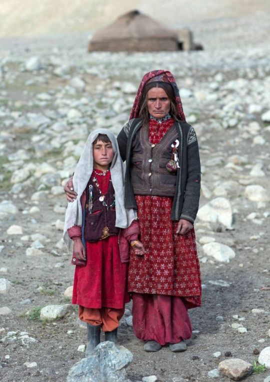
Wakhi nomad boy eating bread in front of his yurt, Big pamir, Wakhan, Badakhshan, Afghanistan. Taken on August 12, 2016.
PayPal Donation: [email protected]
#Eric Lafforgue#Wakhi#Wakhi Nomad#eating#bread#yurt#Pamir#Big Pamir#Wakhan#Wakhan Corridor#Badakhshan#Afghanistan#2016
164 notes
·
View notes
Text
A guide for traveling Tajikistan (Tips + 3-week itinerary)
The ex-Soviet Republic of Tajikistan is a truly wild country that you don’t want to miss in your Silk Road journey.
Home to the Pamir range, one of highest mountain ranges in the world, the mountains of Tajikistan attract the most adventurous travelers, especially those wanting to drive the M-41, or Pamir Highway, an impressive road and architectural masterpiece that goes through some of the remotest and most beautiful mountain scenery in Central Asia.
With tourism increasing year by year, the country is daily becoming more prepared to receive international travelers and, after spending 1 month in the country, I have this compiled this guide that contains all the tips needed for traveling to Tajikistan, plus a compelling 3-week itinerary.
Read: Ultimate guide to the Pamir Highway
Visa
Travel Insurance
Best time to visit
The country, the people and its culture
Getting in
Safety
Scams and corruption
Money
Food and alcohol
Transportation
Useful books
Internet and SIM Card
Accommodation
Itinerary
More information
Total transparency! – If you like my website and found this post useful, remember that, if you buy any service through of my links, I will get a small commission at no extra cost to you. These earnings help me maintain and keep Against the Compass going! Thanks
Do you know what a VPN is? A Virtual Private Network allows you to access blocked sites when you travel, as well as it lets you access content only available in your home country (like Netflix), plus it prevents hackers from stealing your personal data. Learn here why you should always use a VPN when you travel
How to get a visa for visiting Tajikistan
Most likely, you can get an e-visa – Most nationalities can apply for an e-visa through the official portal, valid for any port of entry.
The visa costs 50USD, is valid for 45 days, single entry and takes 1 or 2 working days.
Double entry visa – If you want one, you will have to get it through the embassy. Most people who want a double entry visa do so because they want to travel the Afghan Corridor, accessible from Ishkashim.
If this is your case, these are the requirements:
1 Passport valid for at least 6 months of validity and with two empty pages
Passport copy and visa copy from the country you are applying from
2 Passport photos
US Dollars
I applied for one in Bishkek, Kyrgyzstan, and got it on the same day.
My double entry visa for visiting Tajikistan
GBAO Permit – The Gorno-Badakhshan Autonomous Region (GBAO) is the region located in the east of Tajikistan, where the Pamir Highway and Wakhan Valley are.
If you want to visit it, you must tick the GBAO checkbox in the application form. If you are applying at the embassy, make sure to tell them, so you get the extra stamp.
By the way, the GBAO permit costs an additional 20USD.
Read: 30 Tips for traveling to Kazakhstan
Trekking in GBAO – Things to do in Tajikistan
Travel Insurance for Tajikistan
Eastern Tajikistan, where the Pamir Highway is, is a high altitude area, averaging around 4,000 meters above sea level.
You should know that, if you read the fine print, most insurance companies won’t cover you from 2500-3,000m and above, so you better check before you travel to Tajikistan.
World Nomads, however, does provide cover, including their most basic policy, which already covers for trekking at 4,000m.
CLICK HERE TO GET YOUR FREE QUOTE FROM WORLD NOMADS
If you want to know more options, read how to find the best backpacking insurance
Best time to visit Tajikistan
If you plan to do some trekking in eastern Tajikistan, you should come in summer.
I remember being in Alichur, a small village in the Pamir Highway and one of the coldest places in Central Asia, and, in the morning, during August, it was -5ºC and there was a freezing, strong wind, so it felt even colder.
Imagine the weather there during the rest of the year.
Me, at the top of Gumbezkul Pass. It was the month of August and it was absolutely freezing – Best things to do in Tajikistan
Nevertheless, the Pamir Highway is open all year long so, if you are self-driving, you can drive it at any time. Actually, my friend Joao Leitao from Nomad Revelations drove it in winter.
On the other hand, the Fann Mountains in west Tajikistan are at lower altitude, hence warmer, so they can be visited during spring and fall.
I did the 7 lakes trek in September and it was particularly hot!
The Fann Mountains – Is travel to Tajikistan safe
The country, the people and its culture
After the Soviet Union’s dissolution in 1991, Tajikistan went through a dark period of Civil War that lasted pretty much until 1997 and it was not only in 1999, that they formed an actual, stable government, even though Emomali Rahmon, who is still today President of Tajikistan today, had already been ruling from 1994.
It was one of the countries most affected by the Soviet Union’s breakdown, as all their economy and development depended on the Russians so, after getting their independence, the country went to ruin.
Murghab and all the Pamir highway is really poor – Should I travel to Tajikistan
That crisis can still be seen today, as this is clearly the least developed of all the Stans (not counting Turkmenistan), a country with high rates of unemployment, and the fact that most of their infrastructure is still from the Soviet Union times.
It is also the least Westernized country, also due to the fact they are far from Russia so, unlike Kyrgyzstan and Kazakhstan, their cultural influence is not that visible, hence they have less international exposure.
Actually, after having some conversations with quite a few highly educated Tajiks in Dushanbe, I felt that they don’t really know anything about what is going on in the outside world.
A Soviet truck
They were people with very few Western values and no apparent ambition who asked me many times why I would ever want to travel to Tajikistan.
Moreover, Tajikistan is one of those fake democracies where elections are celebrated but there is only one political party, so the same President has been ruling since 1994.
There is no freedom of speech and I remember when my Australian friend, Sam, was talking to a local man for about half an hour at the main square in Dushanbe, a man in a suit came to ask what was going on and invited him to leave.
This means that, still today, the Government doesn’t like their citizens to get international exposure.
The Tajiks – Tajiks are a Persian ethnic group who live mainly in Tajikistan and Afghanistan, but also in Xinjiang (China) and Uzbekistan.
Actually, nearly half of the total Tajik population live in Afghanistan.
Lovely Tajiks in Khujand – tRAVEL TO tAJIKISTAN
Nevertheless, you should know that, like all the Stans, Tajikistan is ethnically mixed and, actually, most of the people living in the Pamirs are Kyrgyz, whereas those in the Wakhan Valley are Wakhis, so if you want to meet the real Tajiks when you are traveling to Tajikistan, you will have to explore Dushanbe and the western part of the country.
Kyrgyz people from the Pamirs
Language – Tajik, which is a dialect of Persian (the language spoken in Iran and Afghanistan) is the official language. Russian is, of course, widely spoken among most people. English tends to be a problem across all the country. I recommend you learn some basic Russian before you visit Tajikistan.
Religion – Tajiks are Suni Muslims but, like in all Central Asia, religion is not a very big deal. However, I felt that Tajiks were the most religious people in all Central Asia, especially those from the Fann Mountains. I remember that the men there never said hello or shook hands with my girlfriend.
Read: 65 Tips for traveling to Uzbekistan
Tajik women – Tajikistan travel guide
How to travel to Tajikistan
Travel to Tajikistan by air
Traveling to Tajikistan by air is very easy, as there are many international flights connecting Dushanbe with Europe.
If you intend to travel the Pamir Highway, many people fly into Osh, the largest city in southern Kyrgyzstan and the beginning of the M-41 on the Kyrgyz side.
Travel to Tajikistan by land
Moreover, if you want to travel to Tajikistan by land, know that it shares a border with 4 countries and most of them have multiple border crossings.
Kyrgyzstan – There are 6 border crossings and 4 of them are open to foreigners. The most obvious is the Kyzyl Art border crossing, which is the one that follows the Pamir Highway. For more information, read the latest Caravanistan updates.
Kyzyl Art pass: Tajikistan-Kyrgyzstan border – Tajikistan travel guide
Uzbekistan – There are 5 border crossings with Uzbekistan and all of them seem to be open. I personally crossed the one at Konibodom, that links Khujand with the Fergana Valley, but if you don’t plan to visit that region, it is not very convenient. The Oybek border crossing is the one that connects Khujand with Tashkent and Penjakent is the one that connects the Fann Mountains with Samarkand. For more information, check the latest updates on Caravanistan.
Afghanistan – You can cross at Ishkashim, the gate to the Wakhan Corridor and a very safe part of Afghanistan; or the border crossing south of Dushanbe, which is also open but leads to Kunduz, a not very safe part of Afghanistan. Both borders are open but, if you plan to travel back to Tajikistan, remember to have a double entry visa.
China – Apparently, Kulma Pass is open now, as long as you have a valid printed visa on your passport. For more information, check the latest updates on Caravanistan.
Kulma Pass leads directly to the Karakoram Highway that connects Kashgar with Islamabad in Pakistan. Read here the full guide.
Read: 75 Tips for traveling to Kyrgyzstan
Uzbekistan – Tajikistan border crossing
Is it safe to travel to Tajikistan?
In summer 2018, 4 cyclists traveling across Tajikistan were murdered in Danghara, an area relatively close to Dushanbe. ISIS claimed the attack.
That accident triggered a big concern among many travelers and the Tajiks are concerned that it might affect their tourism negatively.
This unfortunate event, however, has been a one-off thing and I personally think that it shouldn’t affect your decision to travel to Tajikistan. A similar case happened in Morocco in December 2018 when 2 Scandinavian girls were killed and, so far, it doesn’t seem that tourism has been affected.
Aside from that, Tajikistan is a safe country with very low crime rates.
Tajiks are always friendly – Is traveling to Tajikistan safe
Scams and corruption when visiting Tajikistan
I still remember being in the car with a homestay owner, on our way to Khujand, when he gave some money to a policeman after stopping at one checkpoint.
Why did you give him money? – I said
Oh, this is just the standard bribing procedure. If we don’t pay him, then he would try to find a reason to fine or arrest us.
The corruption in Tajikistan is a well-known fact and some of these police officers also try to rip off foreigners but luckily, as tourists, there is not much they can do to you unless you are credulous and believe their lies.
Common scams include policemen telling you that there is a problem with your Tajik visa or making you pay an entrance fee to a place that, obviously, doesn’t require an entrance fee.
Dude, just think:
How the hell there is going to be something wrong with your visa?
And also,where have you been where you need to purchase an entry ticket from a policeman?
Just say no and continue with your business.
Epic landscapes
Money when you travel in Tajikistan
The official currency is the Tajik Somoni and, in February 2019, 1USD = 9.50SOM
ATMs and credit cards – You can find ATM’s in the big cities (not in the Pamir Highway).
How much does it cost to travel to Tajikistan
It really depends on where you go and, ultimately, how you travel the Pamir Highway.
Typically, meals cost something between 1 and 3USD and budget homestays around 10-15USD, which tends to include dinner and breakfast.
In Dushanbe, you can find dorms for 3-4USD and the local transportation ranges from 2 to 10USD, depending on where you go.
For all costs referred to the Pamir Highway, read my guide.
Read: 80 Tips for traveling to Iran
We were on a low budget, so we hitchhiked the entire Pamir Highway
Food and alcohol when visiting Tajikistan.
Heads-up.
Like in all Central Asia, the food won’t be the highlight of your visit in Tajikistan.
In the Pamirs and different homestays, you are likely to eat shorpo for every meal, which is a meat broth.
In local restaurants, you will just find things like shahslik, meat skewers; lagman, a noodle soup; manti, fatty meat dumplings; or plov, rice fried in lamb fat.
As per alcohol, as in all ex-Soviet countries, beer and especially vodka are found everywhere.
Lagman is the comodin dish. After eating 100 bowls of it across all Central Asia, I really hated it but since I like pasta a lot, I could handle it more than other dishes
Transportation when you travel around Tajikistan
The below information refers to types of transportation in western Tajikistan, not the Pamir Highway. For this, read my guide to the Pamir Highway.
Marshrutkas – Marshrutkas is what former Soviet countries call their public minivans. They are really cheap and travel between most towns and cities.
Local shared taxis – Actually, we used more local shared taxis than marshrutkas and, as far as I could see, they are the most preferred option among locals.
Hitchhiking – Highly doable and easy! We actually had one of our most crazy hitchhiking experiences, when we spent more than 48 hours in a truck, on our way from Khorog to Dushanbe.
Traveling in a mini UAZ-452 – A classic Soviet van
Books for traveling to Tajikistan
Tajikistan Travel Guide by Bradt – The most comprehensive travel guide to Tajikistan. I bought all the Bradt guides to Central Asia (e-Book format). They are, by far, the most insightful guides I have ever read recently.
CLICK HERE TO CHECK PRICES ON AMAZON
Central Asia Travel Guide by Lonely Planet – I am not a fan of this guide, but if you are traveling to all the Stans and want to buy just one book, it is a good choice as well.
CLICK HERE TO CHECK PRICES ON AMAZON
Internet and mobile when traveling in Tajikistan
Wi-Fi – From Murghab to Khujand and Dushanbe, the Wi-Fi connection when you are traveling in Tajikistan is one of the worst I have ever seen. In Dushanbe, the Wi-Fi in my hostel was particularly bad and then every day I would go work to a fancy café and the internet was down every now and then. In the Pamir Highway and the Wakhan Valley, Wi-Fi doesn’t exist.
SIM Card – 3G was just OK anywhere outside of the Pamir Highway. I bought MegaFon and, for a few Somonis, I got plenty of GBs.
Accommodation in Tajikistan
Homestays – On the Pamir Highway, homestays are the way to go. I recommend you stay in random homestays, not in the popular ones. This way, the benefits will be spread more equally plus random homestays are cheaper.
Hostels – Hostels are popular, from Khorog to Dushanbe and Khujand. Click here to check all the available hostels in Tajikistan!
Hotels – In Khorog, Dushanbe, and Khujand you can find hotel options for mid-range travelers. Click here to check all the available hotels in Tajikistan!
Yurts – In the Pamirs, you can also find nomadic yurt camps where Kyrgyz nomads live.
A yurt camp somewhere in the Tajik Pamirs
Traveling to Tajikistan – 3-week Itinerary
I traveled to Tajikistan from Kyrgyzstan via Kyzyl Art Pass and left through Uzbekistan at Konibodom, so this Tajikistan itinerary reflects the direction I took.
Map of the Tajikistan itinerary
Things to do in Tajikistan – Pamir Highway (8-9 days)
Built by the Soviets in 1930, the Pamir Highway is an architectural masterpiece that goes through some of the remotest landscapes you can ever imagine.
Officially, it starts in Osh (Kyrgyzstan) and ends in Afghanistan but the highest and most beautiful part of it lies in Tajikistan.
The following information is just a small summary.
For the full guide, read my 6,000-word guide to the Pamir Highway.
The stunning Pamir Highway – Tajikistan travel itinerary
How many days are needed for the Pamir Highway?
Well, it is really hard to say. We spent more than 2 weeks between the Pamir Highway and the Wakhan Valley but that is because we stopped in many places plus we also did a 3-day trek.
Normally, most people take a 5 or 7-day tour (starting from Osh), which also includes the Wakhan Valley, but, to be very honest, it is not enough to explore the side valleys, which is where the most stunning landscapes are.
Amazing road! – Tajikistan travel itinerary
If you don’t have the time, I get it but, if you do, here are all the places you need to stop at:
Karakul (1 night) – The first big settlement coming from Kyrgyzstan, Karakul has a very big lake and with some pretty cool snow-capped mountains at the background.
Murghab (2-3 nights) – Murghab is the main town on the M-41 and a base for visiting other places and valleys. We first stayed 2 nights because we waited for a festival and then we stayed a 3rd night after coming back from the trek.
The mosque in Murghab – Tajikistan itinerary
Gumbezkul Pass trek (2-3 nights) – If you have your own car, you can do this trek in 1 day but we did it in 3, cause we walked all the way from Murghab and spent one amazing night with some real nomads in the middle of nowhere. For more information, I wrote the full guide for Everything Everywhere: How to trek the Gumbezkul Pass.
Alichur (1 night) – Very cool landscapes, yaks, trekking and Marco Polo sheep safaris.
Madyian Valley, close to Murghab – things to do in Tajikistan
Bulunkul (Stopover) – The coldest place in Central Asia is home to a beautiful lake. The trek from Alichur to here is a popular one. You can find a few homestays.
For most travelers, the Pamir Highway is, definitely, one of the best things to do in Tajikistan.
For more information, don’t forget to check my guide to the Pamir Highway
The festival we attended in Murghab – Things to do in Tajikistan
Places to visit in Tajikistan – Wakhan Valley (3-4 days)
Many travelers tend to classify the Wakhan Valley as part of the Pamir Highway (M-41), which is completely wrong because they are 2 different places.
Actually, to reach the Wakhan Valley you need to leave the road and drive towards Afghanistan for several kilometers.
The Wakhan Valley
Anyways. The Wakhan Valley is one of my most favorite places in entire Central Asia and my most favorite place in my Tajikistan itinerary.
And the reason is that, besides being home to intriguing and jaw-dropping landscapes, the Wakhan is of great historical importance as the ancient border between North Asia and South Asia and on the remarkable Silk Road route, which can be seen in the many fortresses and other sites of cultural heritage there.
Moreover, in the 20th century, the Wakhan Valley marked the border between the Soviet Union and Afghanistan and the Soviet tanks came through here to invade Afghanistan in the 70s.
Today, the river you will go along during your whole journey, whose other side is in Afghanistan, is the main entry point for smuggling products, especially heroin, and, from the window of your car, you can wave and say hello at the many Afghans across the river, from whom you are separated by only a couple of meters.
Once again, this is a small summary, so for more information, don’t forget to check my guide to the Wakhan Valley in Tajikistan.
The views from Khaaka fortress – Left side is Afghanistan and right Tajikistan – Places to visit in Tajikistan
These are all the places we stopped at:
Langar (1 night) – The first big settlement you find is Langar.
We personally didn’t like Langar, as it is the only place in the Wakhan where the locals are very pushy in trying to promote their homestays, plus it is actually far from the river.
I recommend you continue for a few kilometers to Hisor, a more genuine village and with nicer views to actual Afghanistan.
Vrang (stop) – Vrang is another old village that has an ancient Buddhist temple. It is worth stopping for a few hours.
Yamchun (1 night) – The most striking fortress in the Wakhan, which stands with the Afghan Hindu Kush on its background.
Yamchun fortress – Places to visit in Tajikistan
It also has some famous hot springs called Baby Fatima that are believed to have some fertility benefits.
Namadgut (1 night) – There is nothing in particular to see here but travelers don’t tend to stop here, so it is quite untouched. That is why here we had the best cultural experience with a local woman who blessed us with her hospitality.
Kaakha Fortress – The second most famous fortress after Yamchun has also great views to Afghanistan.
Ishkashim (1 night) – The main town in the Wakhan Valley. It used to hold the Afghan market in no man’s land but it is temporarily closed. It is also the border to Afghanistan for those interested in doing the Afghan Wakhan corridor.
For more information, read my guide to the Wakhan Valley
Wakhi people – Best things to do in Tajikistan
Tajikistan itinerary – Khorog (2 days)
After nearly two weeks of showering with buckets, using holes and bushes as toilets, exclusively eating shorpo and with no internet at all, getting to Khorog felt particularly good.
It is not a very big town but it has a good local market where you can buy many food items that were not available in the Pamir Highway, like cheese, and supermarkets with cold beer.
There is also an Indian restaurant that tends to be filled with travelers and a really good Tajik restaurant by the river, serving high quality grilled meat and other stuff.
Other than this, Khorog is a place to just chill, where we spent 4 days just catching up with work and filling our bellies with decent food.
By the way, the famous Afghan market takes place on Saturday.
Afghan people in the Afghan market of Khorog – A travel guide to Tajikistan
Where to stay in Khorog
Backpacker Hostel – Pamir Lodge – All right, it is a cool place and there is a friendly atmosphere. However, the hostel has the capacity for nearly 100 people and it only has two toilets and two showers, so when I came in August, it was very difficult to find them empty, apart from being quite dirty of course.
Backpacker Hostel – Hostel Do Nazarbayg – An alternative to Pamir lodge. You will find fewer backpackers but the location is much better and it is not that busy.
Click here to see the latest prices
Guest House – Riverside – A quieter, more homestay-style place.
Click here to see the latest prices
The journey to Dushanbe – 1 day
The road to Dushanbe is a very long way.
Shared taxis take around 12 hours and cost 30USD. They leave from near the market but you need to be there early, 7am at most.
We arrived before 8am and there weren’t any marshrutkas or taxis left, so we decided to hitchhike and it took us 3 days, spending more than 48 hours in a truck.
The distance is only 518km but the road is really bad but beautiful and interesting as, again, it goes along the Afghan border for the most part of it.
The road from Dushanbe to Khorog: the left side is Afghanistan and the right Tajikistan
Things to do in Tajikistan – Dushanbe (2 days)
The capital of Tajikistan is another place to chill for a few days while you collect some visas, like the Uzbek or Turkmen visas.
Well, not the Uzbek visa anymore, as from February 2019, they started issuing visas on arrival. Check my Uzbekistan travel guide for more information.
Dushanbe has cafés with real coffee, a variety of restaurants and a few pubs where to hang out at night.
What I liked about Dushanbe is that it was my first introduction to the real Tajikistan, as most people you meet in the eastern part are Kyrgyz, Wakhis or Pamir, so you will see a significant difference with the people living here, especially in the way women dress.
Don’t forget to check the main bazaar and the Rudaki Park, which holds the second tallest flagpole in the world
Where to stay in Dushanbe
Backpacker Hostel – Green House Hostel– We spent so many days here because the hostel was really comfortable. Comfy beds, a big kitchen and a living room with awesome couches.
Click here to see the latest prices
Budget Guest House – Hello Dushanbe – If you want a less backpacker-friendly place, Hello Dushanbe may be slightly more expensive but the facilities are great. It has both private rooms and a dorm.
Click here to see the latest prices
Lovely Tajik women
Hissor Fortress – Day trip from Dushanbe
If you are bored to be in Dushanbe, we also did a day trip to a fortress named Hissor, which was built by the Uzbeks in the 18th century, as this part of Tajikistan used to belong to the Emirate of Bukhara. The north was part of the Russian empire.
All right, the fortress itself was boring, as it was overly refurbished, but we always like to get out of town, take a local marshrutka and just see other towns, so it was worth it only for this reason.
How to get to Hissor fortress
From Dushanbe, you need to take a marshrutka to a town named Khisor. From there, take a taxi or hitchhike back to the fortress which is 4 or 5km away.
The fortress
Places to visit in Tajikistan – Penjakent and the Fann Mountains (3-4 days)
Once again, this is a small summary.
For all the information needed, read my guide to the Fann Mountains.
While they are not as stunning as the valleys around the Pamir Highway, the Fann Mountains are also very pretty and their main advantage is that, unlike the Pamirs, they are heavily populated and filled with several tiny villages where actual Tajik people live.
Tajiks from the Fanns
Therefore, visiting the Fann Mountains is a great opportunity to discover the real Tajik rural life, so different from anything you have seen during your Tajikistan itinerary.
Most people come to the Fann Mountains to visit Iskanderkul lake but I recommend going to the area around Penjakent and doing the 7 Lakes Trek.
Trekking in the Fanns
The reason is that, although Iskanderkul is a beautiful lake, no people live there plus it is always busy with domestic tourists, which isn’t a bad thing, but you won’t see much of the local culture.
On the other hand, the 7 Lakes trek starts in Penjakent and goes through several tiny villages where you can do homestays.
From Penjakent, we took a UAZ-452, the classic Soviet mini-van, and drove to a village named Rachnapollon.
That area is really off the beaten track, so the driver himself invited us to stay at his place, for free, but we decided to give him a generous tip because he had been feeding us.
How to get to Penjakent
First, take a local shared taxi from Dushanbe to Penjakent, which costs 70TJS (8USD). It is a 230km journey.
In Penjakent, for just a few somonis, we got in the UAZ-452 to Rachnapollon, from where we started walking on the next day.
Remember to check my guide to the Fann Mountains
Random people during the trek
Places to visit in Tajikistan – Khujand (2-3 days)
Khujand is the purest Tajikistan in its most genuine form and one of the oldest cities in Central Asia (2,500 years old).
It is the second largest city in the country, a city with little international exposure that has kept its traditional values.
Most travelers use it as a mere transit point, as it is close to the closest border with Tashkent, but I recommend spending here two nights at least.
Arbob Palace Tajikistan
Things to do in Khujand
Don’t forget to check the traditional bazaar, one of those traditional bazaars where everybody asks for a photo and gives you free stuff; and all the mausoleums and historical buildings around the main square. The Arbob Palace is also worth checking out.
Mosques in Khujand
Where to stay in Khujand
Budget Hostel – Somoni Hostel – The best choice for backpackers and a really cool hostel.
Click here to check the latest prices
Budget Hotel – Golden Apartments – The alternative to a backpacker hostel.
Click here to check the latest prices
Khujand’s bazaar
More information for visiting Tajikistan
Here you can find all my articles and travel guides to Tajikistan
And here all my guides to Kyrgyzstan, Uzbekistan, and Kazakhstan.
Traveling to Iran? Find all my articles here
from Cheapr Travels https://ift.tt/2WmI1Xa
via IFTTT
1 note
·
View note
Photo
A nomad woman with her daughter in the Wakhi Province
Image: Exclusivepix Media
133 notes
·
View notes
Text
2536 - Afghanistan ... le corridor du Wakhan, isolé ... accès pour la Chine ... et une "Paix" possible ?
2536 – Afghanistan … le corridor du Wakhan, isolé … accès pour la Chine … et une “Paix” possible ?
1 – Dans un coin perdu d’Afghanistan, un peuple isolé des guerres et des talibans 2 – La Chine installe une base militaire en Afghanistan

1 – Dans un coin perdu d’Afghanistan, un peuple isolé des guerres et des talibans Sultan Belgium, une nomade de la communauté wakhi, dans le corridor du Wakhan, en Afghanistan, le 10 octobre 2017 / © AFP / Gohar ABBAS “Les talibans, c’est quoi ?”,
int…
View On WordPress
#Afghanistan#AFP#Base Militaire#Base militaire chinoise au Badakhshan#CHINE & RUSSIE#le Saker#OBOR#OCS#Peter Korzun#Strategic culture#USA
0 notes
Text
Central Asia Travel
Central Asia Travel
The region of the world known as Central Asia is an extensive terrain covering an area of over one and a 1/2 million square miles. Bordered by Russia to the north and north-west, China and Mongolia to the east and south, the 5 nations inside Central Asia’s boundaries are landlocked aside from to the intense west where the Caspian Sea is located. The countries that include Central Asia are typically known as the “Stans” and consists of Kazakhstan, Kyrgyzstan, Tajikistan, Afghanistan Turkmenistan and Uzbekistan.
Why Travel To Central Asia
Central Asia’s sheer remoteness and lack of data mean it’s not a predominant tourist destination, however, one many adventure travellers plan to travel to Central Asia because of its tremendous natural beauty, rich history, great architecture and special cultures. From the isolated, makeshift villages of the nomadic tribes of Kyrgyzstan, to the ornate mosques of Uzbekistan, to the snow-capped peaks and glacial lakes of Tajikistan, to the gorgeous deserts of Turkmenistan each country has something exclusive and brilliant to discover. A trip to Central Asia is not easy however one that will continue to be with you for a lifetime.
Nature
Central Asia is mountainous and contains some of the highest ranges of anywhere in the world. In the rugged Tian Shan Range in eastern Kyrgyzstan, the easiest peak rises to an extraordinary height of over 24,000 feet. In the interconnecting Pamir Range, the Kongur Tagh surpasses even that by another thousand feet.
While not so steep, the Fann Range in the Sughd Province of Tajikistan is equally, if now not more, impressive. Kazakhstan is additionally home to some stunning mountain ranges and is frequently known as “The Switzerland of Asia”.The mountain degrees in Central Asia make for some of the satisfactory trekking possibilities international and has not often been explored.
Central Asia is home to some of the most lovely lakes and rivers including, Iskanderkul Lake which hides at around seven thousand ft amid the multiple peaks of the Fann Mountains and is a stunningly scenic glacial lake with ice-blue waters.
History & Architecture
Central Asia has a captivating centuries-old history that pre-dates even the days of Alexander the Great. Historically notorious throughout Central Asia is the age-old trading route, the Silk Road. Used by merchants to transport items from country to country, the network of connecting roads crossed continents as far-flung as China and Europe.
It’s nevertheless feasible to tour sections of the Silk Road in a number of components of Central Asia. In Kyrgyzstan, on the route, you’ll see first-hand how the nomadic tribes stay as you and they trip via the mountain valleys.
Central Asia’s Unique Cultures
One of the most captivating components of visiting around Central Asia is the range of cultures you’ll come across. While life goes on in the big cities in a quite modern way, head outside of the huge urbanizations into the remoter areas and that’s a different story. Central Asia is the home to some uncommon nomadic tribes that have wonderful customs and approaches of life that are centuries old and stays unchanged.
The Wakhi people inhabit an isolated region of Tajikistan who speaks their very own Indo-European language. Originating from Iran, the Wakhi are regularly on the go-between their summer and winter camps. They’re additionally seen out herding their cattle throughout the mountain plateaus as they search for food to forage or tending crops they’ve sown on suitable ground.
The Uzbek nomads are a tribal people of undetermined origins however classed as native to Uzbekistan. There are nearly one hundred distinct Uzbek tribes inhabiting quite a number areas of Central Asia as well as China, Russia and Afghanistan. Uzbeks can regularly be seen crossing the open grasslands with trains of camels or riding horses as they go from one region to the next.
The nomads of Kyrgyzstan, or the Kyrgyz, are an ethnic people with a traceable ancestry that dates back to two-hundred BC. The Kyrgyz are observed in the majority inhabiting the Pamir mountains however also in fewer numbers in numerous different locations throughout Central Asia.
Additionally, if you wish to know things like the best places to visit in Central Asia, where to stay, things to do and more you can check out a travel blog that will give you end to end guides on various places you can visit in bolivia and just other travel destination recommendations.
0 notes
Text
New Post has been published on Trekking in Pakistan
New Post has been published on http://bit.ly/2Ew0dXU
Kilik and Mintaka Passes
Duration 6 days Distance 88.4km Standard moderate Season June-September Start/Finish Misgar Zone and Permit open, no permit Public Transport yes Summary For more than 1000 years, Kilik and Mintaka were the Silk Route’s primary passes between China and Hunza, and today these broad valleys and extensive alpine meadows, once closed to foreigners, are again accessible.
Kilik and Mintaka, two historic passes on Pakistan’s border with China, have been off limits to foreigners since 1947. Now open since 1999, the 1m- to 3m- wide trails to these gentle passes are easy to follow, springs and trees are abundant, and camp sites are grassy, making this one of northern Pakistan’s easiest treks.
PLANNING
Maps
The US AMS 1:250,000 topographic map Baltit (NJ 43-14) covers the trek except the area between Shireen Maidan and Kilik Pass. The only map to depict this area is the US DMA 1:500,000 topographic map TPC G-7A, but the scale renders it useless for trekking. The U502 map doesn’t show the road to Kalam Darchi. The trail beyond Boi Hil to Gul Khwaja Uween is shown on the Mintaka River’s true left bank, but it’s along the true right bank all the way between Murkushi and Gul Khwaja Uween.
Guides and Porters
The system of portering and stages was first introduced to Misgar in 1999. Most village men Know Kilik Valley, their primary summer pastures, but few know Mintaka Valley beyond Yatumgoz Harai. They’re unaccustomed to carrying loads and don’t have metal-frame carries. Misgar men typically use donkeys to transport their own loads to the pastures, and prefer to do the same with trekkers’ loads. One donkey carries up to two loads, but is slow. Start out with donkeys from Misgar because you cannot rely on finding any available donkeys upvalley.
Misgar’s nambardar Ataullah and village elders set porters’ wages at a flat per stage, including payment for food rations and the clothing and equipment allowance. Misgar also has yaks, but during summer yaks don’t go below Murkushi. Additionally, Misgar sets a rate of per load for yaks, which carry two loads.
Stages
These stages were set during a July 2000 meeting in Misgar attended by this book’s authors and Misgar’s Board of Governors, which included the nambardar, religious leaders, representatives of the Pamir Cattle Breeding Farm and village political leaders.
The entire village agreed to and accepted these stages: Misgar to Arbab-e-Bul (ie, it’s half a stages between Misgar and Kalam Darchi plus half a stage between Kalam Darchi and Arbab-e-Bul); Arbab-e-Bul to Murkushi; Murkushi to Sad Buldi; and Murkushi to Gul Khwaja Uween.
The trek described covers a total of eight stages not including the side trips. When you hire a vehicle between Misgar and Kalam Darchi, subtract half a stage for each direction that porters ride and don’t carry a load.
The village prefers Gurgun Pert as the overnight place and stage in Mintaka Valley as opposed to Gul Khwaja Uween, which they feel is too cold and too high for porters to sleep. At the time of research, however, there was no usable porters’ hut at Gurgun Pert. It’s in the interest of trekkers to camp at the more scenic Gul Khwaja Uween, which is a far superior site for the Mintaka Pass side trip. But, it’s in the interests of porters to camp lower at Gurgun Pert so they don’t have to walk as far with loads. (It’s 8km or 2½ hours between Murkushi and Gurgun Pert, and 3.5km or 1½ hours between Gurgun Pert and Gul Khwaja Uween.) Time will tell how this will work out. Meanwhile, it’s important to discuss this and reach an agreement before starting.
When you visit either pass on a day trek and your porter accompanies you with no load, you pay one stage for each day trek. Therefore, you pay one stage round trip when you go from Sad Buldi to Kilik Pass and back, or from Gul Khwaja Uween to Mintaka Pass and back. When you do both side trips to Kilik and Mintaka Passes as day treks, the trek becomes a total of 10 stages.
The side trip to Hapuchan Valley is also done as a single-stage day trek. When porters carry a load to the head of Hapuchan Valley, it’s one stage. A final wrinkle is that if you have porters move your camp above Sad Buldi or Haaq to Luto Harai, it’s one stage.
The Last Outpost of the British Empire
Misgar is the farthest village in the upper Hunza Valley. Settled in the 19th Century by Burusho from Hunza who were sent by the Mir of Hunza to guard against Qirghiz raiders from the Pamirs, it’s toady one of Gojal’s few Burushaski-speaking villages. The Mir’s distant outpost became, after the British conquest of Hunza in 1891, the empire’s farthest outpost. From Misgar, British sportsmen travelled across Kilik Pass (4827m) to the Taghdumbash Pamir in China in search of game and to learn of the movements of Russian travellers as part of the Great Game, the 19TH-century Anglo-Russian rivalry in Central Asia. Misgar was linked to Gilgit by a telegraph line, and later by a telephone line. The British employed men as mail runners to carry weekly British dispatches between Misgar and the British consulate in Kashgar. The mail runners reached Tashkurgan is six days from Misgar, via the Mintaka Pass (4726m), which was the standard route prior to the 1986 opening of the Karakoram Highway over the Khunjerab Pass. Today’s trekkers can also visit Kilik Pass where Lord Curzon, later viceroy of India (1899-1905), stood in 1894 at the outermost edge of Britain’s empire.
NEAREST VILLAGE
Misgar
Sitting high above the Kilik River’s true left bank, the sunny village has its own electricity supply, telephone and post office. Misgar (3075m) was once populated by Wakhi speakers who abandoned the valley due to intense raiding by Qirghiz nomads from Wakhan. The village was resettled in the 19TH century by Burushaski speakers from Hunza, who give their own pronunciation to the area’s many Wakhi place names. In Wakhi, mis means ‘nose’ and gar means ‘rock’, a description of the shape of the rock inside the flag-festooned roadside shrine (astan) in the village’s centre. Legend has it that butter used to drip from the stone until a greedy villager attempted to gather too much, and the blessed butter ceased to flow.
Places to Stay
The 90-year-old British customs house on the village’s east side has been revamped into the small Kilik Guest House by its owner, Shifaullah. A small grassy area surrounded by a pretty flower garden has space for two tents. The old officer’s bedroom inside bed and the camping on fee. The welcoming family serves good food on the attractive covered porch. Other villagers offer rooms in their homes at comparable rates and, at the time of research, plans were afoot to build commercial hotels in the village and a camping area on its outskirts.
Warning
Trekkers can go to Kilik and Mintaka passes as far as the large concrete border markers, erected by the Survey of Pakistan in 1964, but should not enter Chinese territory. Chinese guards patrol the border area and will arrest anyone attempting to illegally enter China. Any such incident would likely result in the immediate closing of Misgar to foreigners. Misgar villagers have no interest in seeing their earnings from tourism brought to a premature end. Therefore, they justifiably insist that no foreigner should visit the pass areas unless accompanied by a villager. Respect their legitimate concerns and cooperate in keeping this fascinating and historic area open.
Getting There and Away
Misgar is beyond the Afiyatabad check post, so immigration officials ask to see your passport. The 16km well-maintained Misgar Link Rd leaves the KKH 15 minutes north of Afiyatabad. Wagons to Misgar depart Gilgit’s Jamat Khana bazaar directly for Misgar at 7am, Stopping in Afiyatabad at 1pm, and arriving in Misgar shortly after.
From Afiyatabad, the 30-minute ride to Misgar, and special hires. Daily Wagons depart Misgar for Gilgit between 6 and 6.30am.
GETTING To/From THE TREK
The road continues north to Kalam Darchi. Misgar-Kalam Darchi special hires 7km, 20 minutes.
THE TREK
Day 1 : Misgar to Murkushi
6-7 hours, 21km, 584m ascent
It takes 1½ hours to walk 7km along the road between Misgar and Kalam Darchi. Follow the Kilik River’s true left bank past several springs. Fifteen minutes before Kalam Darchi, the road crosses a bridge to the river’s true right bank. At the base of Kalam Darchi Fort it crosses another bridge over the Dilisang River back to the Kilik River’s true right bank. Here a sign posted by the Pamir Cattle Breeding Farm shows a ‘Y’ with the left fork pointing north-west to ‘Dilleson’ (Dilisang) and the right fork pointing north to ‘Kilik/Mintaka’. The road ends and the trail begins near the abandoned riverside army barracks. Kalam Darchi, locally called KD, was built as a Gilgit Scouts post in the late 1930s on the site of an old Hunza watchtower, and was manned by the Pakistan Army until 1994. Now only caretakers occupy the post.
The trail follow the Kilik River’s true right bank a few minutes and crosses a well-built footbridge to its true left bank. In five minutes is the grassy area of Khan Wali (3205m), above which are the remnants of a British check post. Soon the trail goes along talus at the base of a scree slope as it parallels and then crosses a clear tamarisk- lined side stream called Bahadur Khan-e-Bul (Bahadur Khan’s spring). Fifteen minutes farther is a faint trail junction. Veer left on the trail that drops and crosses the river on a footbridge. Called Phari Bridge, it was built to replace a footbridge farther upstream that washed away in a flood.
Once on the river’s true right bank, climb a short rough bit to the level sandy area where the footbridge used to be. Here the Kilik River is broad and shallow in contrast to the swift-moving River downvalley. Thirty minutes farther is Arbab-e-Bul (the arbab’s spring). Mature birch trees and willows line a clear stream through this grassy area. Across the river is a black terminal Moraine from a side glacier. The trail stays along the Kilik River’s true right bank all the way to Murkushi, passing through a series of inviting level grassy birch groves about every 30 minutes, named Rung Hil, Put Hil and Lup Jangal. Between each grassy area is a stony section, but the Well-made broad trail is easy to follow and allows you to enjoy the towering cliffs on either side of this broad, well-watered valley.
Murkushi (3659m), the last and largest of these grassy birch-dotted plains, is 14km from Kalam Darchi at the confluence of the Kilik and Mintaka rivers. A herders’ hut and livestock pen lies at Murkushi’s south end, but the best camp sites are among Birch trees towards the north end beneath huge granite cliffs. Clear water flows in a small tamarisks-lined stream near the Kilik River.
Day 2 : Murkushi to Sad Buldi
4½ hours, 11.7km, 585m ascent
Between Murkushi and Sad Buldi the landscape changes radically from the steep spires and rocky summits of the Karakoram to the rounded, rolling grasslands of the pamir. Cross a slopping footbridge to the Kilik River’s true left bank and make a short but sheep climb to join the main trail heading north-west upvalley. The broad trail rises steadily beneath huge, sheer, water-polished granite cliffs and spires, and one hour from Murkushi reaches the first grassy area (3870m), which has a spring and a few birch trees. The area between here and the livestock gate upvalley is called Ship Shepk.
Thirty minutes farther, a huge trailside spring emerges from rock and in five more minutes the trail passes through the livestock gate. Ahead the trail crosses a former lake bed and continues another hour to ford a large clear side stream through a grassy area called Sisghil. Gumbish, a Qirghiz tomb bedecked with Marco Polo Sheep horns, marks the south end of Shireen Maidan, a level plain with a polo field marked out in stones and some crumbling stone walls and a spring at its north end. The Kilik Pass is visible from here.
Beyond Shireen Maidan and Kuz Nala, the side valley directly opposite, the landscape changes to that of the Pamir. The gentle the trail continues along closer to the river, and crosses a clear stream at Shapt Pud (wolf’s foot). The broad windswept plain of Sad Buldi (4244m), 45 minutes to one hour from Shireen Maidan, has a herders’ hut and livestock pen amid boulders near the tumbling Kilik River. Across the river behind a low rise is the herders’ hut and livestock pen of Haaq, where the village’s herders live. Large boulders on both sides of the Kilik River have petroglyphs showing horse riders, hunting scenes, ibex, naked male figures and Buddhist swastikas, evidence of a long and varied human usage of Kilik. Sad Buldi is preferable to Haaq as a camp site, with more grass, less grazing, more privacy and easier access to clear water. Misgar men prefer staying at Haaq where there’s more activity and fresh dairy products.
Side Trip : Kilik Pass
4-4½ hours, 11km, 583m ascent, 583m descent
The trail to Kilik Pass begins on the Kilik River’s true right bank, so ford the river when staying at Sad Buldi. Two trails lead upvalley, joining one another at Luto Harai. One is a livestock trail along the river, and the other is a traverse high above the river on flower-carpeted hillsides. It’s easier to follow the river route upvalley and return along the high route.
From the Haaq side of the river, follow the livestock trail along the grassy flower-strewn stream Bank. Pass the confluence of the stream Descending from the rounded Uween Pert, to the right, then cross the Khush Dur Stream flowing in from the left 30 minutes from Sad Buldi. Continue along the Kilik River’s true right bank, occasionally hopping rocks from side to side as needed. Pass through the extensive grassy area of Harhurutum Goz Harai (the grassy plain where yaks come to sit and stay). At Luto Harai (Luto’s pasture), two hours from Sad Buldi, are several tumbledown stone walls once used as a herders’ camp. A side stream opposite (east of) Luto Harai, feed by a gigantic snowfield, is Khoja Ghoom (where the Khoja got lost).
Leaving the Kilik River, head left up a rocky hillside trail to the level grassy area above. Continue north across the broad rolling Pamir to Kilik Pass (4827m), which is half an hour from Luto Harai. The pass area is 2km-to 3km-wide plateau, and the pass itself has a border marker and a sizable lake nearby. The views north into China are of rocky peaks. Some easy walk-up peaks, in Pakistan territory, are near the pass area, but they do not offer substantially enhanced views.
Return to Luto Harai, then stay above the river (to the right) and traverse beautiful slopes with excellent views downvalley. This route stays high all the way back and drops down directly above Haaq.
Side Trip : Hapuchan
4½ hours, 14km, 200m ascent, 200m descent
Hapuchan is a tributary of the Kilik Valley, branching west from Haaq. A leisurely day trek follows the river’s true left (north) side to the valley’s head. The faint trail crosses rocky outwash fans interspersed by small grassy areas. At the valley’s upper end, a side valley to the north leads to Hapuchan Pass on the Chinese border, a Marco Polo sheep habitat. Another side valley leads south to Wodwashk Pass (see Other Treks,).
Day 3 : Sad Buldi to Murkushi
3-3½ hours, 11.7km, 585m descent
Retrace your steps downvalley to Murkushi (3659m). If you’re fit, feeling strong, and can convince any porters, this day combines easily with Day 4.
Day 4 : Murkushi to Gul Khwaja Uween
4 hours, 11.5km, 537m ascent
The broad Mintaka Valley retains a typical Karakoram feel, and its reddish-brown granite terraces and cliffs, level grassy areas, numerous side streams and waterfalls give it a dramatic but pleasant quality. The easy walk is on a 2m- to 3m-wide, well-built trail that ascends four short rocky sections, remnants of ancient landslides that once dammed the river, and crosses four broad level grassy areas, former lake beds, now home to many marmots. The trail stays along the Mintaka River’s true left bank the entire way.
From Murkushi, cross the slopping footbridge to the Kilik River’s true left bank and continue east, passing above a small hut. The trail climbs and stays above the milky Mintaka River as they Valley bends north-east. In one hour reach Iletum Harai, the first long level grassy area where island-like mounds carpeted by wildflowers dot the broad river. A braided cascade tumbles over granite across the river. At the upper end of his area, more than 1km long, is Jurjur Hil Goresho, with another impressive cascade across the river. Clean water from more falls along the river’s true right bank make this a possible camp site.
Beyond the waterfalls, climb a rocky area 15 minutes to another level area. Fifteen minutes farther, Yatumgoz Harai (4509, ‘upper grass’), a herders’ hut and livestock pen, sits along the River’s true left bank, two hours from Murkushi. This stretch has no clear water. The glacier on the valley’s east (right) side is Ashural Gamu, and on the valley’s west (left) side, hidden from View high above the trail, is grassy area and lake called Gurgun Pert.
Fifteen minutes beyond Yatumgoz Harai, pass a footbridge, the route back to the hut. Shortly beyond it, cross a side stream, the outwash from Gurgun Pert. The trail heads north-east through a mixed rock and grass area, soon passing a herders’ hut and livestock pen with collapsed walls (also called Gurgun Pert). The whole area is known as Boi Hil.
The trail continues through a flatter grassy area with a clear stream coming from the base of a big black terminal moraine that emerges from the north-west. This moraine dammed the river in the not-distant past, and the trail traverses the talus-covered moraine, then drops into the Valley’s last level upper section after 45 minutes. This recently dammed area has significantly less vegetation than those below and the river lies in braided channels across the grey expanse.
Skirting the river’s edge, the trail soon reaches Gul Khwaja Uween (Gul khwaja’s Pass) with a dramatic granite cliff behind it, over which two free-leaping cascades tumble. Attractive grassy terraces on the cliffs above and the clear white central ice of the Gul Khwaja Uween Glacier to the south-east gives this camp site a dramatic appeal. Two huts provide porters’ shelter, near which are several grassy camp sites (4169m). The Pakistan Army, which used this area until the early 1990s, built many roofless stone shelters, now weed-filled and tumbling down. Those that face the route to Mintaka Pass have small apertures in their walls for gun placements.
Side Trip : Mintaka Pass
4-4½ hours, 7.5km, 530m ascent, 530m descent
The route to Mintaka Pass is visible from Gul Khwaja Uween. The pass lies just beyond the low saddle in the cliff walls above the glacier’s north-east margin. The military- made 1m- wide trail is still serviceable and easy to follow, although rock fall and some moraine collapse means scrambling over short sections. Flowers decorate the moist hillside, which supports good marmot and ram chukor populations. The area around Mintaka Pass abounds in brown bear and wolf signs, and even those of the elusive snow leopard. All in all, Mintaka is the more dramatic of the two passes.
From Gul Khwaja Uween, head south-east and cross the braided clear side stream. Follow is true left bank upstream, then past the base of a cliff onto the Gul Khwaja Uween Glacier’s lateral moraine. The trail leads to gently graded switchbacks that wind up a grassy slope to the obvious saddle, two hours from Gul Khwaja Uween. Turn east and walk through a marshy flower-filled area. The trail keeps left (west) across black talus to Mintaka Pass (4726m), half an hour from the saddle. The pretty 500m-wide pass lies between two large rocky peaks. At the border marker, look into the broad, lush Lupgoz (big grass) Valley, but the aware that a Chinese border post sits about 500m beyond the border marker. Return via the same route.
Day 5 : Gul Khwaja Uween to Murkushi
3½ hours, 11.5km, 537m descent
Retrace your steps downvalley to Murkushi. You can do this following your visit to Mintaka Pass if you’re fit and your porters are willing.
Day 6 : Murkushi to Misgar
5 hours, 21km, 584m descent
The valley stays shaded well into mid-morning, which is a good incentive to start early on hot days. Stroll easily downvalley on the broad trail to Kalam Darchi, then follow the even easier road back to Misgar.
Other Treks
The following treks are all in an open zone, except where noted.
SHATUBAR GLACIER
From Gulmit, follow the road behind the village one hour to Kamaris village (2800m). A side trip goes 30 minutes north-east to the ruins of Andra Fort, built about 200 years ago to protect against Nagyr raiders. Heading west from Kamaris, follow the trail towards the Gulmit Glacier’s terminus in one hour and continue along its south margin 1km, or half an hour, then turn south and ascend 800m to the summer pastures of Rajabhil. From the ridge-top saddle above Rajabhil, the trail descends south to the pastures of Bulkishkuk and Shatubar, below the Shatubar Glacier, before turning east and south returning to Gulmit. Allow two or three days for this moderate loop trek.
AROUND PASSU
Borit Sar
Borit Sar (4105m) is the rocky ridge top between the Ghulkin and Passu glaciers (see map,). It can be done as a day trek from Passu (2400m) or Borit Lake, as an overnight trip from Passu, camping at Passu Ghar, or as a side trip to the Patundas trek from Passu Ghar. The in-your-face views of peaks and glaciers from Borit Sar make it the best day trek along the KKH for mountain scenery. The moderate trek is possible mid-May to October, and takes seven to eight hours round trip when going quickly or eight to 10 hours when going more leisurely. This stiff trek gains 1705m and descends 1705m in elevation.
The trail to Borit Sar leaves the trail to Patundas at the slate platform (see Day 1 of the Patundas trek,). From the slate platform (2865m) to Borit Sar and back takes from six to seven hours, covering 5.5km. Follow an old faint trail along the ridge line up through broken rocky sections, marked by small cairns. Continue up over open artemisia-dotted slopes, past scatted juniper trees to the level top of Borit Sar, five hours from Passu. From this high point overlooking the Passu and Ghulkin glaciers and Borit Lake, 10 7000m peaks, including distant Rakaposhi, Diran and Malubiting, are visible in a 360-degree panorama. Immediately in front of you are killer views of Shishpar, Bojohagur-Duanasir and Ultar’s north face.
Two Bridges
An easy and popular five-to six hour day trek from Passu, locally knows as the ‘two bridges’ trek, crosses the Hunza River twice over hair-raising suspension bridges (see the Avdegar map,). The trek offers good views of the Ghulkin, Passu and Batura glaciers and peaks above Ghulkin and Passu, and is much easier that the trek to Avdegar. Follow the Day 1 description of the Avdegar trek (p) from Passu via Yashbandan over the first footbridge to Zarabad. Follow the trail that skirts the cliffs above the Hunza River’s left bank to an equally interesting footbridge crossing back over the Hunza River to Hussaini. Return to Passu along the KKH, or spend the night at Borit Lake.
Yunz
The glacially formed north-south Yunz Valley lies parallel to and west of the Hunza Valley, between the Passu and Batura glaciers (see the Patundas map,). The easy 15.8km loop through Yunz Valley is a popular six-to eight-hour day trek with excellent glacier views, but lacks any big mountain views. The trail ascends 480m and descends 480m, and is feasible April to October. A guide isn’t necessary, yet every year trekkers get lost along this trail. If you’re uncertain about finding your way through unfamiliar terrain, hire someone or look for a companion. It’s two stages total: Passu to Yunzben; and Yunzben to Passu. Yunz Valley is dry and water at Passu Lake and Yunzben is Silty, so carry water from Passu.
From Passu (2400m), walk 10 minutes south on the KKH to the first building (2580m) on the KKH’s west side before the bridge. Follow a trail past a usually empty concrete water tank and follow the canal through thorny scrub. The clear trail, marked by small cairns, skirts the base of a rock buttress. Cross a flat, stony area 15 minutes from the KKH and ascend the old terminal Moraine to see Passu Lake (not marked on any map), formed about 1989 when the Passu Glacier retreated. (The old trail to Yunz Valley was destroyed by a landslide, so the only trail now is via Passu Lake.)
Continue around the lake’s north shore to its far west end. Follow cairns and ascend the Gravelly gullies amid dark, glacially polished rock. At times, the trail and the cairns are hard to find. As you ascend, Passu Glacier’s dark ice is to the south (left). Don’t stray too far left, and don’t go onto the crevassed glacier. The trail soon becomes more obvious. As the angle begins to lessen, the white-toothed Seracs of the Passu Glacier to the west and the Yunz Valley to the north appear.
Continue up the now scree-covered trail to the top of the rock formation, 30 minutes from the Lake. A clear trail angles up and to the east (right), across the face of the grey lateral moraine on the valley’s north side. Reach the base of this moraine in 15 minutes and go up the trail. At the top, turn west and enter an ablation valley with a few junipers, sage and wild rose bushes. Follow a trail through the ablation valley 10 minutes. Then turn north up a gully and in five to 10 minutes reach a slate slab bench at the top and the actual start of Yunz Valley (2775m) . After one hour, at the upper (north) end of the valley, there are two huts (3000m) west of the trail where the worthwhile side trip to Zart Sar (yellow top), a scenic overlook of Passu village, Tupopdan and the Hunza Valley, starts and finishes. The side trip to Zart Sar (labeled as Sart on the Swiss map) takes 1½ to two hours round trip, follow the trail that heads east and around the north end of the rocky bluffs that rise above the Yunz Valley’s eats side to a rocky plateau.
The main Yunz Valley trail continues north from the huts. Stay right and descend briefly to a small terrace (3060m) overlooking the Batura Glacier with some tumbledown huts, a scenic lunch spot. Descend steeply over scree and loose soil 15 minutes to Yunzben in the ablation valley along the Batura Glacier’s south margin. See Day 1 of the Batura Glacier trek (p) for a description back to Passu.
SHIMSHAL
Momhil Sar Base Camp
Momhil is an enormous 26km-long glacier that flows north from Momhil Sar (7343m), east of and parallel to Shimshal’s Lupgar Valley (see the Shimshal River map,). Momhil Sar, Trivor, Destaghil Sar and Mulungutti Sar (7025m) are the prominent peaks attracting mountaineers to this valley. It’s a moderate four-day trek to the base camps for these four peaks of the Hispar Muztagh.
The trail heads south from the road, east of the bridge over the Momhil River a few minutes’ jeep ride beyond Dũt. On Day 1 reach Yazmis in three to four hours. On Day 2 reach Chikareen in eight hours, passing Khumreg and then Shilmin halfway. On Day 3, reach Momhil Base Camp (4300m) in seven to eight hours, passing Ambareen just beyond halfway. The return trip from base camp to the bridge can be done in one long day on Day 4. It’s 10 stages total round trip from Dũt: (1) Yazmis; (2) Shilmin; (3) Chikareen; (4) Ambareen; (5) Momhil Base Camp; and (6-10) five stages to return via the same route.
A three-day climb of Ambareen Sar (6175m), east of Momhil Glacier, is possible from Ambareen. Set a high camp (5000m) on Day 1, summit and descend to 5800m on Day 2, returning to Ambareen on Day 3.
Yazghil Sar Base Camp
Yazghil (sheep pen by the glacier) are the summer pastures nearest Shimshal village. From Shimshal village, you can reach Yazghil in one long day, explore the area for another day, and return to Shimshal the third day. Perched high above the 31km-long Yazghil Glacier’s south-east Margin, the huts (4500m) and pastures above have excellent views of the peaks at the glacier’s head: Yukshin Gardan, Kunyang Chhish, and the Yazghil Domes.
The trail heads east from Shimshal village, staying along the Shimshal River’s true left bank, three hours to the huts at Yazben (at the glacier’s base). Head up the lateral moraine along the Glacier’s west margin and cross to the south-east margin reaching Yazyand (after the glacier), the first hut along the Yazghil Glacier’s south margin, three to four hours from Yazben. From the ablation valley, ascend the grassy hillside steadily another three to four hours to herders’ huts and Yazghil Sar Base Camp (3600m).
A local guide is necessary to show the way across the glacier. This moderate trek totals six stages round trip from Shimshal village: (1) Yazben; (2) Yazyand; (3) Yazghil; and (4-6) three stages to return via the same route.
From base camp, it’s a three day-snow and ice climb to reach the summit of Yazghil Sar (5964m). Set a high camp (4670m) on Day 1, then ascend the south summit and bivouac (5180m) on Day 2, returning to base camp on Day 3.
Kanjut Sar Base Camp
Kanjut Sar (7760m), one of the hard-to-see summits of the Hispar Muztagh, is accessible from Shimshal village on a moderate five-or six-day trek that also offers close-up views of neighboring Jutmo Sar (7330m) and Yukshin Gardan. Kanjut Sar is known locally as Kunjlaksh (mountain above narrow place, referring to the narrow width of the glacier that resembles a Kunj, the narrow part of a Wakhi home near its entry).It takes three days one way to reach Base camp from Shimshal village, although it’s possible to do it in two. It’s eight stages total Round trip, four up and four back.
The route follows the Shimshal River’s true left bank south-east, crosses the Yazghil Glacier’s terminus, and continues towards the Khurdopin Glacier. It crosses the Yukshin Gardan Glacier above its confluence with the Khurdopin Glacier to Chagh Chagh (labeled as Cheng Cheng on the Swiss map). Here the route turns south-west and heads up the Yukshin Gardan Glacier, Staying near the glacier’s north-west (true left) margin most of the way to base camp (4600m). One tricky outwash-stream crossing via a cable adds a little excitement. Flowers carpet the meadow at base camp (marked by a triangle on the Swiss map), which also has junipers nearby, inviting you to spend an extra day.
Qapachpund and Chilinj Passes
Longer and more challenging routes than the standard trek (see the Shimshal Pamir trek,) exist to reach Shuwerth in the Shimshal Pamir. Two technical and extreme passes, Qapachpund and Chilinj, link the 38km-long Virzherav Glacier and Shuwerth. Virzherav is Shimshal’s most distant pasture and its name probably derives from the Wakhi word thir, which means a ‘distant’ glacial valley (zherav).
From Shimshal village, the routes head east towards the Khurdopin Glacier and branch south-east up the Virzherav Glacier. They follow the Virzherav Glacier’s north-east (true right) margin to Arjal-e- Dur. Arjal-e-Dur is a narrow side valley, named for a black and white yak, Arjal, which strayed up this side valley, which meets the Virzherav just at the letter ‘b’ in ‘Virjerab’ on the Swiss map.
The route across Qapachpund Pass (5270m on the 1:100,000 Russian map J-43 128), goes up Arjal-e-Dur and continues north towards the valley’s head. From the pass, the route descends to Zhit Badav, the extensive plain just below Shuwerth. It takes six days one way from Shimshal village to Shuwerth via Qapachpund Pass. The pass is not shown on any maps, but is on the ridge east of peak 5930m on the Swiss map.
A longer, higher and harder route crosses Chilinji Pass (5600m on the 1:100,000 Russian map J-43 140). This route also leaves Virzherav at Arjal-e-Dur, but turns north-east as Arjal-e-Dur bends in a more northerly direction. From the pass, the route descends Bhakityar Dur to the Braldu River below its confluence with Wesm-e-Dur. The route stays along the Braldu’s true left bank to Chikor, where it turns north-west to Shuwerth. It takes eight days (and 11 stages) one-way Shimshal village to Shuwerth via Chilinji Pass, crossing the pass on the sixth day. It’s necessary to place high camps on both sides of the pass, which is marked by an ‘X’ on the Swiss map.
Ghidims Pass
Ghidims Pass (5486m) crosses the Central Asian watershed between Ghidims Valley, an upper tributary of Ghuzherav, and Sher IIaq Valley, Shimshal’s prized winter pastures. The existence of the pass was unimagined until the first crossing by the book’s authors in June 2000. In pioneering the route, the authors were also the first westerners to reach Sher IIaq. The upper Ghidims and upper Sher IIaq valleys have many attractive unclimbed alpine peaks, all inviting first ascents.
See Days 1-4 of the Boisum and Chafchingol Passes trek (p) for a description between Shimshal village and Mandikshlakh where the route leaves Ghuzherav, and discussion of these stages. From Mandikshlakh, allow a minimum of nine days round trip for this 68km very demanding and technical trek to Arab-e-Dur-e-Gush, Sher IIaq’s main herders’ hut.
Head north-east up the Ghidims Valley to Laili Camp (4475m) at the confluence of the North and south Ghidims valleys. The route leads up the South Ghidims Valley to the second eastern side valley. Ascend the side valley first along the outwash stream’s true left bank and then on scree along the unnamed glacier’s true right margin to Sarwar High Camp (5150m). The next Day, cross the glacier and ascend scree to an obvious notch left of a yellow-and-brown rock band well before reaching the glacier’s upper basin. Three obvious cols at the glacier’s head are not the pass. The nonglaciated Ghidims Pass has steep 40-degree scree on both sides, and is Snow-free late in the season.
Descend scree to the North Rost-e-Dur Glacier, and cross the crevassed upper glacier to its true left margin. Follow the ablation valley downvalley to grassy Mirza Camp (4642m). The next day, head down Rost-e-Dur, passing the Chap-e-Dur hut, to the confluence of Sher IIaq and Arab Khan-e-Dur. Blue sheep and brown bears live in Sher IIaq, and the likelihood of seeing them is high. On the return, set a camp on moraine below the pass on its east side, called Fazal High Camp (5060m).
Mountaineering equipment necessary to travel in roped teams on the glaciers on both sides of the pass is required. It’s 11 stages total round trip from Mandikshlakh. It’s 1½ stages one way between Mandikshlakh and Laili Camp. It’s eight stages round trip from Laili Camp to Sher IIaq, four stages each way: Sarwar High Camp, Fazal High Camp, Mirza Camp and Arab-e-Dur Gush.
Lukpe La
The northward flowing Braldu Glacier, not to be confused with the Braldu Valley in Baltistan, offers a technical and extreme route across the Lukpe La (5650m), first crossed by HW Tilman in 1937, linking the Shimshal Pamir and Lukpe Lawo. From Shuwerth in the Shimshal Pamir (see Day 3 of the Shimshal Pamir trek, p), the route descends to the Braldu River, turns south, and begins the difficult ascent along the heavily crevassed 36km- long Braldu Glacier. The Wesm Mountains, named for ibex trails where animals Knock rocks down, rise to the east. Crossing Lukpe La, at the valley’s head, requires travelling in roped teams and possibly fixing Ropes for Safety. The 500m descent over 3km from the rounded saddle guarded by gaping crevasses heads south-west on the Sim Glacier to its confluence with the Biafo Glacier, from where you the descend the Biafo Glacier to Thungol (see the Hispar La trek,). Depending upon who you ask, it ranges from five to seven stages between Shuwerth and Lukpe La. Everyone agrees that it’s one stage from Lukpe La to the confluence of the Sim and Biafo glaciers. This extreme technical trek is in a restricted zone where a permit and licensed guide are required (see Trekking permits,). Due to its remoteness, self-rescue is the only option in the event of accident or injury.
Khurdopin Pass
The technical Khurdopin Pass (5790m) is an extreme mountaineering route that links Shimshal village with Lukpe Lawo. Although Tilman reached the pass from Lukpe Lawo in 1937, it was first crossed in 1986 by Canadian Cameron Wake with Shimshalis Shambi Khan and Rajab Shah. Accomplished mountaineer Stephen Venables, who crossed the pass in 1987, rates it an alpine Grade III suitable only for experienced mountaineers.
From Shimshal village, follow the Shimshal River south-east, crossing the Yazghil Glacier, and continue along the river towards its source at the Khurdopin Glacier’s terminus. Traverse the 37km-long Khurdopin Glacier below its confluence with the Yukshin Gardan Glacier, exiting above its confluence with the Virzherav Glacier. Now along the Khurdopin Glacier’s east margin, which flows from Kanjut Sar I (7760m) and II and Lukpe Lawo Brak, the toilsome route heads south along this vast river of ice.
High on the East Khurdopin Glacier, the dangerous route stays to the east, crossing the heavily crevassed base of an icefall before ascending the huge icefall with steep, loose rock in a snowy gully. The route near the pass requires fixing ropes over classic wind slab with avalanche danger. The 600m descent from the pass to Lukpe Lawo is a 50-degree ice wall acute avalanche danger, returning fixing ropes. From Lukpe Lawo, you can descend the Biafo Glacier to Thungol (see the Hispar La trek,). Allow up to six days between Shimshal village and Lukpe Lawo.
SHIKARZHERAV
East of Sost is a very demanding six-day near-loop trek that accesses the isolated valley formed by the North Qarũn Koh Glacier’s outwash stream where more than 300 blue sheep reportedly roam. From Sost, the route heads up the Shikarzherav for the first night’s camp, passing beneath the rocky south face of Sost Sar (5200m), and then along the glacier’s north margin. At the valley’s head, it crosses a ridge (below 6000m) and descends along the river’s true left bank. Camp three nights heading upvalley, watching for wildlife. Leaving the valley, the route turns west, ascends a side valley and crosses a 5774m ridge. The descent from this ridge follows a drainage leading to the Khunzherav near Kilik IIga on the KKH just north of Sost. Hire a local guide who knows the way.
CHAPURSAN
Pamiri
Pamiri is the summer pasture used by Zood Khun herders. The moderate four-day walk to Pamiri starts from Yishkuk and heads south-west along the Yishkuk Glacier’s north-west margin. This trek is good for additional acclimatization before crossing either the Lupgar Pir Pass or Chilinji An. The trailhead (3450m) is on the west side of the bridge spanning the Yishkuk River. As the road bends to the right near old lateral moraine, climb along the river’s true left bank. Continue past the glacier’s mouth along the ablation valley on its west side to Kuk Chesham, a herders’ settlement with a reliable spring. The next day pass Sekr (labeled Lal Mitti on maps), the prominent red rock, just beyond Kuk Chesham. Continue in the ablation valley to Dush Zhui, a small lake with clear water in an open green area. The trail continues up the ablation valley, ascending gradually to Pamiri, a lovely place to rest and enjoy the views. The stream is called Pamiri, locally referred to as Banafshayeen because banafsha grows here. From Pamiri, either retrace your steps back to Yishkuk or cross the Yishkuk Glacier and walk back along the glacier’s opposite side, crossing the low ridge to join the trail down from Kit-Ke-zherav. It’s six stages total round trip from Yishkuk: (1) Kuk Chesham; (2) Dush Zhui; (3) Banafshayeen; and (4-6) three stages to return via the same route.
MISGAR
Chapursan to Misgar
Two passes link Misgar’s Dilisang Valley, the westernmost of Misgar’s valleys, with Chapursan (see map,). Kermin Pass links Kermin village with the lower Dilisang Valley just above Kalam Darchi. It’s an easy five-hour day trek across this pass.
Another unnamed demanding pass links Zood Khun with Wergisht Khun in the upper Dilisang Valley; contact Alam Jan in Zood Khun if you’re interested in tackling this pass.
Wodwashk Pass
Obscure and little known parts of the Karakoram are still out there. Wodwashk, the glaciated pass linking the Hapuchan Valley, the western tributary of Kilik Valley, and Wodwashk Bar, a northern tributary of the Dilisang Valley, is one (see the Kilik and Mintaka Passes map,). The demanding route is reportedly easier when starting from Dilisang. It heads up the well-watered and green Wodwashk Bar, staying on its true left bank. The pass involves 30 to 60 minutes of glacier travel, and the descent is along into Hapuchan. Bring an ice axe and rope for safety; crampons aren’t necessary.
Anyone interested in attempting this pass can contact Misgar’s nambardar Ataullah who knows the unmarked route and pass area called Tung-e-Tuk. Correspondence can be sent in advance of arrival to PO Misgar, Village Misgar, District Gilgit, Northern Areas. No stages are set in the Dilisang Valley or across Wodwashk Pass.
0 notes
Photo
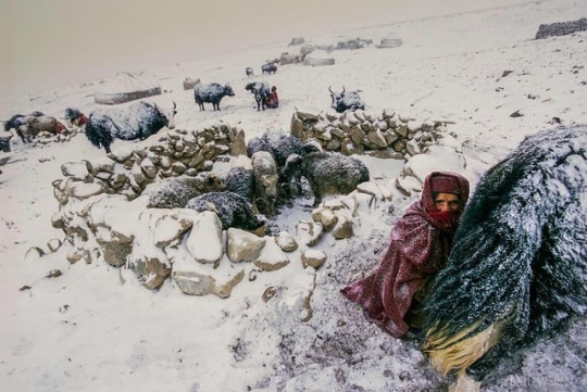
Photo by @bethjwald // As we approach the new year, winter has an icy grip on large parts of the US, and I am remembering wintery travels around the world - snowy landscapes, sun low on the horizon, icy winds and frosty breaths, short days, long nights and gathering in the dark around the fire. In this archival photo, taken in 2004 on Kodachrome slide film, Wakhi women milk yaks in a snowstorm at a shepherds’ camp in the Big Pamirs at the end of the Wakhan Corridor, a remote region in northeast Afghanistan; young yaks huddle in a a stone corral. The Wakhi are the indigenous people of the Wakhan and they eke out a spare living as agro-pastoralists in this high, cold landscape, growing a few high altitude crops in the valleys and grazing their sheep, goats and yaks in mountain pastures, which they share with their Kyrgyz neighbors, who live nomadically on the higher plateaus, and trade with the Wakhi for grains and other supplies. Life in the Wakhan is hard and impoverished for many – there is little medical care, only basic education, high infant mortality and opium addiction are significant problems and the winter months are particularly brutal, but the Wakhi are proud of their culture, their ability to survive and their freedom on the “Bam-i-Dunya” or Roof of the World. Recognizing the beauty, the mountain ecosystems that support wildlife including snow leopard, bear, wolves, ibex and Marco Polo sheep, and the unique cultures of the Wakhan, the Afghan government declared the whole district a National Park in 2014. I have been celebrating this season with posts of snow and ice, cold beauty and hard times, waiting, hoping for the light to return. See more at @bethjwald #Afghanistan #wakhancorridor #Afghanpamirs #Pamirs #mountainculture #Badakshan #roofoftheworld #bamidunya #wakhi #Wakhilife #Wakhan #nationalpark #onassignment #centralasia #agropastoralist #yak #nikonnphotography #nikon #wintersolstice #lightanddark #winterlandscape #frost #analogphoto #realfilmphotography #throwbackthursday #kodachrome #onassignment @thephotosociety @ilcp_photographers @natgeocreative http://ift.tt/2E8Y95t
1 note
·
View note
Text
30 Photos From Afghanistan That You Won’t See In The News
Traveling in Afghanistan
Afghanistan
Last summer I traveled into the mountains of Afghanistan for a two week backpacking adventure. Not your typical summer vacation destination. Here’s what I witnessed on my journey.
What comes to mind when you think about Afghanistan? War? Terrorism? Osama Bin Laden? The Mother Of All Bombs?
Sure, much of Afghanistan is still dangerous — but there’s also incredible beauty, hospitality and kindness in the country that doesn’t get reported on.
It’s far too easy to vilify or write-off an entire nation when you don’t have to look those people in the eyes. People with the same hopes and dreams as you — to survive, find happiness, and provide for their families.
I was able to experience the positive side of Afghanistan and its wonderful people, up close and personal, during my trip there last summer. It’s since become my most memorable travel adventure to date.
Here are some of my favorite photos of people & landscapes from my 100 mile trek into Afghanistan’s remote and mountainous Wakhan Corridor.
This is the “other” side of Afghanistan that you don’t see in the news.
The Hindu Kush Mountains
Traveling in the Wakhan
Wakhan Corridor
The Wakhan is a rugged and wild region of Northeast Afghanistan, part of Badakhshan Province. It’s a narrow peice of land, about 400 km long, surrounded on three sides by Tajikistan, China, and Pakistan.
Two large mountain ranges dominate the area, the Pamir in the North, and the Hindu Kush in the South. The Wakhan Corridor was created by politicians in the 1800’s during the “Great Game” in an attempt to leave a buffer zone between British India and the Russian empire.
Riding Yaks in the Wakhan
Hitchhiking By Yak
Taking a break from walking, I managed to hitch a ride on a yak for a portion of the route. We ran into a group of Wakhi men leading their yaks through the mountains. While they stopped for tea, they let us borrow their yaks, which we led further into the valley until their owners caught up with us later.
Yaks are the ultimate eco-friendly 4×4 in Afghanistan, able to climb steep rocky terrain and power through icy cold rivers. There are no trees above 10,000 feet, so locals are forced to trek for 3 days to lower elevations with their animals in order to gather firewood for cooking and warmth.
Ruined Stone Shelter on a Vast Landscape
Trekking in the Wakhan
Ancient Silk Road
The Wakhan was once part of the ancient silk road, an important trading route connecting China to Europe. Along with silk, horses, and other goods, it was a highway for armies and explorers too. Explorers like Marco Polo who is believed to have passed through here during the 13th century.
Crossing steep mountain passes and high desolate plateaus, passing caravans of yaks and donkeys loaded with goods, spending the night in stone shelters with traveling merchants — I felt like I was getting a glimpse of what the silk road must have been like all those years ago.
Muslim Shopkeepers in Afghanistan
My Compatriots in the Wakhan
The Many Faces Of Islam
Just like the many different branches of Christianity, there are many different branches of Islam, all with their own beliefs and values. Many people living in Afghanistan’s Wakhan Corridor are Ismaili Muslims, who practice a moderate form of Islam. They number 25 million worldwide, and despise the Taliban.
Their spiritual leader is the Aga Khan, a successful British businessman and Imam who runs the Aga Khan Development Network, a super important charity organization that improves living conditions and opportunities for the poor in Africa and Central Asia.
Footbridge Over the Wakhan River
Untamed Blue Rivers
The Wakhan River runs through the Wakhan Corridor, fed by the high altitude mountains of the Hindu Kush on the border with Pakistan. It snakes its way through the mountains, and is a major lifeline for the people living in this harsh and unforgiving landscape.
The bright blue color of this water is due to reddish hues of the rock formations around it, as well as the crystal clear source (a glacier). Water molecules absorb other colors, like red, more efficiently than blue.
Enjoying the Wild Landscape
Snowy Mountains in August
Epic Mountain Views
When the weather was clear, I was rewarded with incredible views of the mountains like this! The trail was well worn, as it’s used daily by small groups of locals who travel in caravans of yaks or donkeys from settlement to settlement.
The 10 day trek ranged in altitude from 10,000 to 16,000 feet, and we averaged about 10 miles per day of hiking. I began to feel the effects of altitude on my body around 12,000 feet with shortness of breath. At 16,000 feet hiking became even more tiring and difficult.
Snow Covered Yurts
Kyrgyz Settlement in the Wakhan
Portable Yurts
The Kyrgyz people of Afghanistan are semi-nomadic, moving from valley to valley herding their animals to different grazing pastures depending on the season. They live in cozy yurts made of sheep felt, which can be broken down and transported long distances.
Each settlement consists of 2-3 families living and working together. Originally from the area around Kyrgyzstan, their ancestors were kind of trapped in the Wakhan after the Soviets took over Central Asia, forcibly settled nomadic tribes, and sealed off the silk road route.
Sheer Chai Milk Tea
Salty Milk Tea
Both the Wakhi and Kyrgyz people drink large amounts of salty milk tea, called Sheer Chai. It’s served for breakfast, lunch, and dinner. Basically, it’s a mix of yak and goat milk, boiled down for hours and dried into a portable block. It’s prepared by adding boiling water, loose-leaf tea, and rock salt.
The salt is great for rehydration at high & dry altitudes — I called it my Afghan Gatorade. It took a while to get used to (salty hot milk anyone?), but by the end of the adventure my body was craving sheer chai for every meal. You can also dissolve raw butter into the tea at breakfast for extra calories.
Petroglyphs in Afghanistan
Afghan Petroglyphs
Near the end of my 2nd day on the trail, we hiked past a set of ancient petroglyphs scrawled into a dark colored boulder overlooking the valley. My local guide, Yar, couldn’t tell me much about them, other than they think these markings are a few thousand years old.
They depict hunting scenes, men armed with what appear to be bows, as well as large game like ibex and the rare Marco Polo sheep. This was just one of many petroglyphs that dot the landscape in these mountains. They are thought to mark ancient hunting grounds claimed by different tribes.
Central Asia Institute School
Kyrgyz Boys Ready for Class
CAI Schools
This simple 3 room school in the remote Afghan village of Bozai Gumbaz was built by Greg Mortenson and his Central Asia Institute. You may have heard of Greg before, he’s the author of the best selling novel Three Cups Of Tea, about building schools for girls in Pakistan.
The school at Bozai Gumbaz, where I spent the night playing cards with Afghan army soldiers, was prominent in his 2nd book, Stones To Schools. The next morning a group of boys showed up on donkeys for class. I saw many CAI schools along the road from Eshkashim to Sarhad-e Broghil.
Camping in Afghanistan
Camping In Afghanistan
As a big fan of the outdoors, one of the highlights on this trip was the opportunity to wild camp in the mountains of Afghanistan. Most nights we were able to stay at small Wakhi or Kyrgyz settlements in basic guest huts, but we also camped out in tents a few nights too.
Normally I’m a camping hammock kind of guy, but because I knew there weren’t going to be any trees for most of this trek, I packed my super lightweight Nemo Hornet 2P Tent. It snowed a few times during the journey — in August!
Greetings From the Heart
Friendly Shopkeeper in Eshkashim
As-Salāmu ʿAlaykum
I was constantly greeted with As-salāmu ʿalaykum which means “peace be upon you”. A shorter version of this is just salām. Shaking hands is common, and so is placing your hand on your heart, which simply means your greeting comes from the heart.
Another important term I used during my journey is taschakor, meaning thank you. I always recommend trying to learn 10 of the most used words in a local language before traveling there. In the Afghan Wakhan, most people speak some Dari (Farsi) along with local dialects.
Afghan Woman Wearing Blue Burka
Wakhi Girl in Sarhad-e Broghil
Women In Afghanistan
Many people were asking if I saw women in Afghanistan. Yes I saw women during my trip, but most were extremely shy, especially if I had my camera out. Plus in their culture, talking with strange men is taboo. But shooting portraits of men or kids was not a problem.
Near the border town of Sultan Eshkashim, which is primarily Sunni Muslim, many women wear the full-length blue burqa that covers their face. In more rural areas of the Wakhan, it’s less strict. Women wear long colorful dresses with a simple headscarf. I was able to say hello and see their faces.
Kyrgyz Tombs at Bozai Gumbaz
Khajahbigali Family Tomb
Shrines & Tombs
I encountered a few ancient burial tombs during my time exploring the Wakhan Corridor. Near the Afghan military outpost of Bozai Gumbaz, there’s a collection of strangely shaped Kyrgyz beehive tombs, along with evidence of Soviet bombing (craters, bomb fragments) from the 1980’s occupation.
At the settlement of Langar, we found a pile of ibex horns marking the burial place of a powerful big man. In Afghanistan, wealthy & powerful men are often called “big men”. It’s a bit like calling someone “boss.” The more animals, land, and wives you have, the “bigger” & more influential you are.
Driving in Afghanistan
Rough Roads
Before I began the 10 day, 100 mile trek through the mountains, I had to hire a 4×4 van to drive me to the last village at the end of the road. We passed a few military checkpoints along the way, stopping for tea & candy with officials before continuing on.
The drive took 2 days, and the roads were some of the worst I’ve ever seen. Dust seeped into the vehicle, covering us in dirt. We forded rivers, drove along the edge of sheer cliffs, and were frequently stopped by huge herds of goats blocking the road. The van suffered 6 flat tires during the journey.
Cooking Lunch in a Stone Shelter
Wakhi Settlement
Wakhi Settlements
While I entered Afghanistan alone, I decided to hire a local translator/guide and horseman to accompany me on the trek into the mountains. It would have been extremely difficult to communicate with people without their help. We spent the night at a few Wakhi settlements during the hike.
Wakhi homes are basically stone huts with dirt floors, constructed using manure for cement. The roof is made of logs, grass, and more manure to keep it waterproof. Some shelters had stoves inside, others just had a fire pit. Either way it was pretty smoky…
Young Afghan Girl in Sarhad
Wakhi Family Living in the Mountains
Children Of The Wakhan
Life in the Wakhan is rough, especially for kids. About 60% of children here die before the age of five, the highest infant mortality rate in the world. If they do survive, they are put to work helping out with the family business — animal herding.
There are a few schools out here, thanks to the Central Asia Institute, but it’s up to the parents if they go. In some communities, only the boys are sent to school. The morning commute can take a few hours by donkey due to the lack of roads and distance between settlements.
Central Asian Bactrian Camel
Wildlife In Afghanistan
I was really hoping to see a snow leopard or Marco Polo sheep while I was traveling through the mountains of Afghanistan’s Wakhan Corridor. You know, Walter Mitty style! Unfortunately both of these endangered animals are extremely difficult to spot — but I did find camels!
Luckily the Wildlife Conservation Society has staff in the area, often spending weeks in the field gathering data to protect wildlife in the Wakhan. They estimate there are about 100-200 snow leopards living in these mountains. Wolves and bears also call this wilderness home.
The Country You Thought You Knew…
The Other Afghanistan
So there you go. A peek at the other side of Afghanistan that we never see on the nightly news. After traveling the world extensively for the past 6 years, I’ve noticed this is a common theme.
Don’t let our media, which is primarily focused on negative & sensational topics, be your only window into the dynamics of a foreign country you’ve never been to.
I’m not going to tell you that Afghanistan is safe. It’s not. Our troops who’ve served there can tell you. Afghans themselves are well aware of the dangers that plague their country too.
But I think there’s another side to Afghanistan that deserves some attention. The rugged, scenic mountain landscapes. The friendly, hospitable local people.
I’m hopeful for the day when Afghanistan’s problems fade away, and more travelers can safely enjoy the beauty this incredible country has to offer. ★
Bonus Video! Backpacking Afghanistan
Subscribe to my YouTube Channel for new Adventure Travel Videos!
(Click to watch Backpacking Afghanistan – Wakhan Corridor on YouTube)
Pin This On Pinterest:
READ MORE FROM AFGHANISTAN
How To Visit The Wakhan Corridor
Have any questions about Afghanistan? What do you think? Drop me a message in the comments below!
This is a post from The Expert Vagabond adventure blog.
0 notes
Photo

@worldwide.freedom.fighter from @thewonderfulpakistan - Karambar lake Karambar lake is the 2nd highest lake of Pakistan with highest value of water clarity level among lakes in Pakistan. Karambar lake lies on the border of Broghil Valley of Chitral dist(KPK) & Ishkoman valley of Ghizer Dist(GB) near to Durand line, Wakhan province (Pamir settlement of Kerghiz & wakhi nomads) of Afghanistan. Photo by Mujtaba [email protected] - #regrann
0 notes
Photo
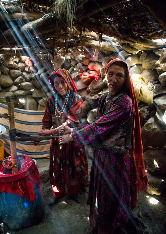
Wakhi nomad women making butter in the pamir mountains, Big pamir, Wakhan, Afghanistan. Taken on August 10, 2016.
PayPal Donation: [email protected]
#Eric Lafforgue#Wakhi#Wakhi nomad#nomad#butter#pamir#Pamir Mountains#Big Pamir#Wakhan#Wakhan Corridor#Afghanistan#2016
105 notes
·
View notes
Photo
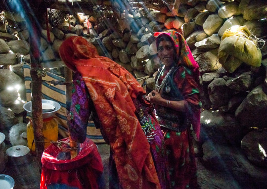
Wakhi nomad women making butter in the Pamir mountains, Big pamir, Wakhan, Afghanistan. Taken on August 10, 201.
PayPal Donation: [email protected]
#Eric Lafforgue#Wakhi#Wakhi Nomad#nomand#Pamir#Big Pamir#Wakhan#Wakhan corridor#Badakhshan#Afghanistan#2016
76 notes
·
View notes
Photo

Wakhi nomad teenager sitting near a solar panel, Big pamir, Wakhan, Afghanistan. Taken on August 11, 2016.
PayPal Donation: [email protected]
#Eric Lafforgue#Wakhi Nomad#Wakhi#teenager#solar panel#Pamir#Big Pamir#Wakhan#Wakhan Corridor#Afghanistan#아프가니스탄#阿富汗#アフガニスタン#אפגניסטן อัฟกานิสถาน#Афганістан#अफ़गानिस्तान#Афганистан#افغانستان#2016
32 notes
·
View notes
Photo


Two portraits of a Wakhi nomad woman, Big pamir, Wakhan, Afghanistan. Taken on August 11, 2016
PayPal Donation: [email protected]
#Eric Lafforgue#Wakhi#Afghan#Afghan Woman#Wakhi Nomand#Wakhi nomad woman#Wakhi Woman#Big Pamir#Wakhan#Wakhan corridor#Badakhshan#Afghanistan#افغانستان#2016
193 notes
·
View notes
Photo
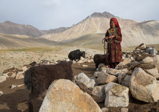
Wakhi nomad woman taking care of her yaks, Big pamir, Wakhan, Afghanistan. Taken on August 11, 2016
PayPal Donation: [email protected]
45 notes
·
View notes
Photo

Portrait of a wakhi nomad mother with her daughter, Big pamir, Wakhan, Afghanistan. Taken on August 11, 2016
Wakhi mother and her daughter in the Big Pamir, Afghanistan. Want to meet them too? Easy: fly Dushanbe in Tadjikistan, drive 2 days on the most awful off roads to Khorog, then drive to afghan border in Ishkashim. Add one day drive to Uzed (awful road too) then rent yacks, and walk for 2 days to reach them at 4500 m in the mountain...Those people live in the worst conditions you can imagine, with only their sheeps and yacks, and they say they are poor but happy...
PayPal Donation: [email protected]
#Eric Lafforgue#Wakhi#Wakhi Woman#Afghan#Big Pamir#Wakhan corridor#Wakhan#Pamir#Khorog#Ishkashim#Badakhshan#Afghanistan#2016
42 notes
·
View notes
Photo
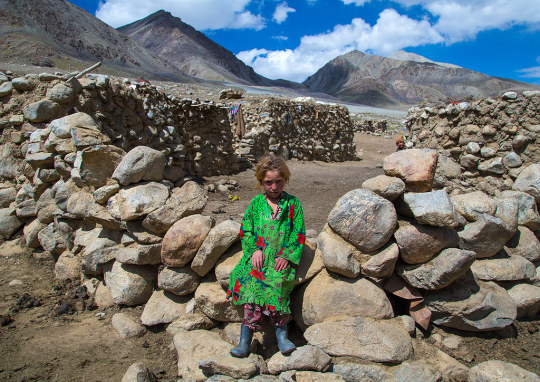
Wakhi nomad girl with blonde hair, Big pamir, Wakhan, Afghanistan. Taken on August 10, 2016.
PayPal Donation: [email protected]
#Eric Lafforgue#Wakhi#Wakhi nomand#Wakhi girl#blonde#Big Pamir#Pamir#Wakhan#Wakhan Corridor#Badakhshan#Afghanistan#2016
26 notes
·
View notes
Last Seen Blogs

bewellseo
Untitled

ivxnvasiliev-blog
survivor;

blobdeco
the splatoon sideblog

postersbydave-blog
Posters By Dave

d3ad-and-buried
Zai