#Yerington Nevada
Text
jerma killed by bees.
In other news Joan Kirby from Yerington, Nevada, is in love.
1 note
·
View note
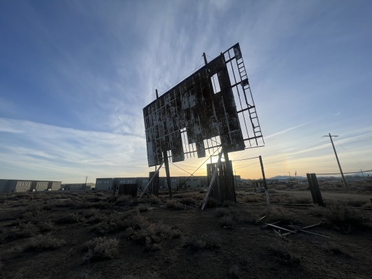
Text
Abandoned Sage Crest Drive-In, Yerington, NV
The Sage Crest Drive-In is a classic Americana gem off Highway 95 in Yerington, Nevada. According to Cinema Treasures, it opened in 1953 and closed in 1984. Under new management, it reopened in 1991 and closed again in 1995. It still has the ticket office and projector house. Check it out at sunrise or sundown for some good photo ops…
View On WordPress
#abandoned#abandoned drive-in#americana#cool#Mark Loftin#markloftin#Nevada#Road#Road Trip#roadart#roadtrip#Solo Explorer#Travel
1 note
·
View note
Text
Yurington Police Seek Public's Help in Locating Dennis 'Denny' Stewart
Dennis 'Denny' Stewart, a 58-year-old man was reportedly planning a move to Titusville, where he intended to live with a friend. Stewart was last seen on May 15th.
Yerington Police in Nevada are seeking assistance from the public in their ongoing search for a man who has been missing since mid-May
Dennis ‘Denny’ Stewart, a 58-year-old man was reportedly planning a move to Titusville, where he intended to live with a friend. Stewart was last seen on May 15th.
However, it remains uncertain whether Stewart made it to his intended destination as his family…

View On WordPress
0 notes
Conversation
U.S. Daily Snowfall Records Tied/Broken 12/11/22
Anchorage, Alaska: 9.02" (previous record 5.98" 2007)
Kings Canyon National Park, California: 1' 2.02" (previous record 7.01" 1996)
Modoc National Forest, California: 3.5" (previous record 2.99" 2003)
Mt. Hamilton summit, California: 2.52" (previous record 0.31" 1994)
Portola, California: 1' 0.01" (previous record 6.5" 2015)
Tahoe National Forest, California: 2' 6.98" (previous record 1' 5.01" 1920)
Windsor Locks, Connecticut: 5.59" (previous record 4.49" 1957)
Unincorporated Ada County, Idaho: 2.99" (previous record 0.31" 1982)
Boise, Idaho: 0.98" (also 0.98" 1984)
Howe, Idaho: 2.01" (also 2.01" 1992)
Dagget Pass summit, Nevada: 2' 6" (previous record 5" 1993)
Unincorporated Douglas County, Nevada: 2.99" (previous record 0.98" 2003)
Unincorporated Douglas County, Nevada: 6.5" (previous record 1.3" 2015)
Unincorporated Eureka County, Nevada: 7.01" (previous record 2.01" 2016)
Unincorporated Nye County, Nevada: 2.01" (previous record 0.98" 1949)
Unincorporated Nye County, Nevada: 0.51" (previous record 0" 2021)
Stead, Nevada: 4.02" (previous record 1.5" 1992)
Unincorporated Storey County, Nevada: 1' 2.02" (previous record 4.02" 1889)
Unincorporated White Pine County, Nevada: 4.29" (previous record 3.9" 1968)
Yerington, Nevada: 0.91" (previous record 0.51" 1945)
Hanover, New Hampshire: 4.02" (previous record 3.58" 1923)
Colonie, New York: 6.61" (previous record 4.29" 1970)
Maine, New York: 5.12" (previous record 4.09" 1992)
Saratoga Springs, New York: 4.49" (previous record 3.31" 2014)
Unincorporated Deschutes County, Oregon: 0.51" (previous record 0" 2021)
Unincorporated Jackson County, Oregon: 5.98" (previous record 5" 1983)
Unincorporated Jefferson County, Oregon: 2.99" (previous record 0" 2003)
Unincorporated Millard County, Utah: 0.51" (also 0.51" 1985)
#Storms#Winter#U.S.A.#U.S.#1990s#1920s#Idaho#1980s#Nevada#1940s#1880s#New Hampshire#New York#Oregon#Utah#1970s#Connecticut#1950s#1960s#Alaska#Crazy Things#Awesome
0 notes
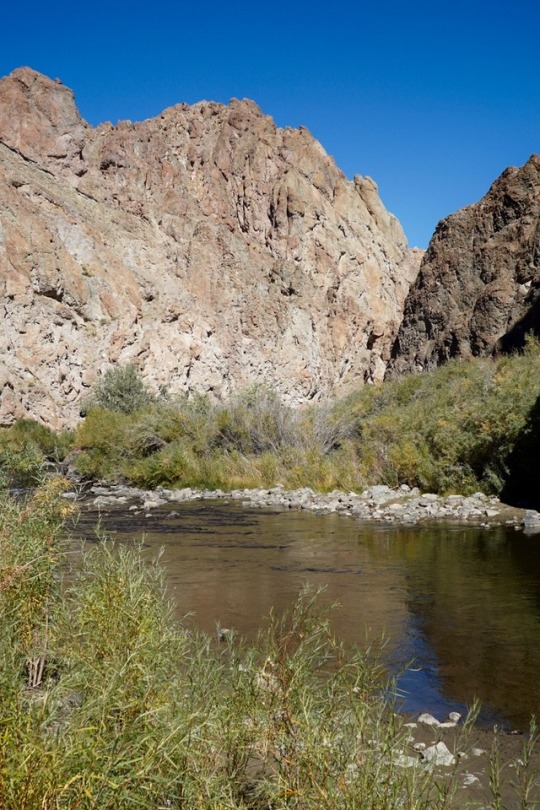
Photo
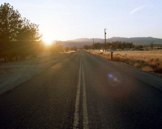
Country Road
Yerington, Nevada
Hasselblad 500c/m
Kodak Ektar 100iso
#Country Road#road#road trip#on the road#sunset#travel#Nevada#Yerington Nevada#photography#photo#photographers directory#original photographers#photographers on tumblr#photographerslife#photographer#film photography#film is not dead#film#Hasselblad 500c/m#Hasselblad#120#medium format#Kodak Ektar 100iso#kodak
152 notes
·
View notes
Photo
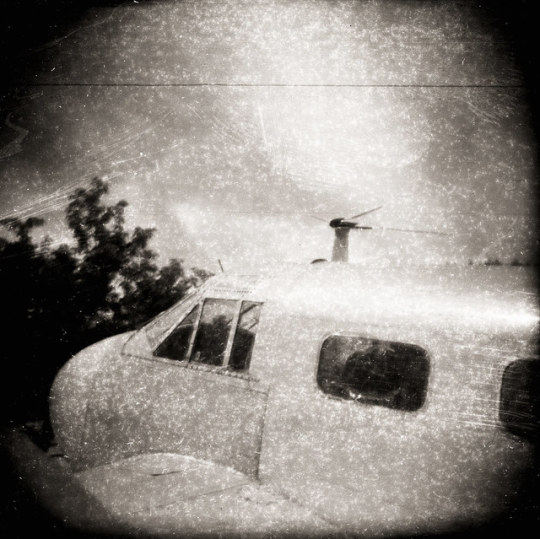
DC-3
Holga 1970's Tura 21 D-76 1+3 Yerington, Nevada
On Flickr
© Eben Ostby June 19, 2019 at 07:09AM. All rights reserved
9 notes
·
View notes
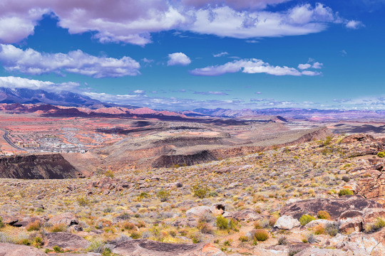
Photo
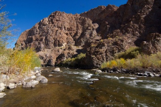
Wilson Canyon
Yerington, NV
13 notes
·
View notes
Text
Ku Stevens to Run With His Great-Grandfather
This is a good education about the indoctrination and kidnapping Native children were forced to endure.
Ku Stevens will run 50 miles in remembrance of his great-grandfather’s escape attempts from the Stewart Indian School in Nevada.
When Stevens’ great-grandfather, Frank Quinn, was a child, he was placed in the Stewart Indian School, a military-style boarding school. Stewart and the roughly 200 schools like it were compulsory, often written into the treaties that granted Native Americans their own…
View On WordPress
1 note
·
View note
Text

• Fu-Go Balloon Bomb
A Fu-Go, or fire balloon (風船爆弾, fūsen bakudan, lit. "balloon bomb"), was a weapon launched by Japan during World War II.
The fūsen bakudan campaign was the most earnest of the attacks. The concept was the brainchild of the Imperial Japanese Army's Ninth Army's Number Nine Research Laboratory, under Major General Sueyoshi Kusaba, with work performed by Technical Major Teiji Takada and his colleagues. The balloons were intended to make use of a strong current of winter air that the Japanese had discovered flowing at high altitude and speed over their country, which later became known as the jet stream. The jet stream reported by Wasaburo Oishi blew at altitudes above 30,000 ft (9.1 km) and could carry a large balloon across the Pacific in three days, over a distance of more than 5,000 miles (8,000 km). Such balloons could carry incendiary and high-explosive bombs to the United States and drop them there to kill people, destroy buildings, and start forest fires. The preparations were lengthy because the technological problems were acute. A hydrogen balloon expands when warmed by the sunlight, and rises; then it contracts when cooled at night, and descends. The engineers devised a control system driven by an altimeter to discard ballast. When the balloon descended below 30,000 ft (9.1 km), it electrically fired a charge to cut loose sandbags. The sandbags were carried on a cast-aluminium four-spoked wheel and discarded two at a time to keep the wheel balanced. Similarly, when the balloon rose above about 38,000 feet (12 km), the altimeter activated a valve to vent hydrogen. The hydrogen was also vented if the balloon's pressure reached a critical level.
The control system ran the balloon through three days of flight. By that time, it was likely over the U.S., and its ballast was expended. The final flash of gunpowder released the bombs, also carried on the wheel, and lit a 64 feet (20 meters) long fuse that hung from the balloon's equator. After 84 minutes, the fuse fired a flash bomb that destroyed the balloon. The balloon had to carry about 1,001 pounds (454 kg) of gear. At first the balloons were made of conventional rubberized silk, but improved envelopes had less leakage. An order went out for ten thousand balloons made of "washi", a paper derived from mulberry bushes that was impermeable and very tough. It was only available in squares about the size of a road map, so it was glued together in three or four laminations using edible konnyaku (devil's tongue) paste – though hungry workers stealing the paste for food created some problems. Many workers were nimble-fingered teenaged school girls.
The bombs most commonly carried by the balloons were, Type 92 33-pound (15 kg) high-explosive bomb consisting of 9.5 pounds (4.3 kg) picric acid or TNT surrounded by 26 steel rings within a steel casing 4 inches (10 cm) in diameter and 14.5 inches (37 cm) long and welded to a 11-inch (28 cm) tail fin assembly. Type 97 26-pound (12 kg) thermite incendiary bomb using the Type 92 bomb casing and fin assembly containing 11 ounces (310 g) of gunpowder and three 3.3-pound (1.5 kg) magnesium containers of thermite. 11-pound (5.0 kg) thermite incendiary bomb consisting of a 3.75-inch (9.5 cm) steel tube 15.75 inches (40.0 cm) long containing thermite with an ignition charge of magnesium, potassium nitrate and barium peroxide.
A balloon launch organization of three battalions was formed. The first battalion included headquarters and three squadrons totaling 1,500 men in Ibaraki Prefecture with nine launch stations at Ōtsu. The second battalion of 700 men in three squadrons operated six launch stations at Ichinomiya, Chiba; and the third battalion of 600 men in two squadrons operated six launch stations at Nakoso in Fukushima Prefecture. The Ōtsu site included hydrogen gas generating facilities, but the 2nd and 3rd battalion launch sites used hydrogen manufactured elsewhere. The best time to launch was just after the passing of a high-pressure front, and wind conditions were most suitable for several hours prior to the onshore breezes at sunrise. The combined launch capacity of all three battalions was about 200 balloons per day. Initial tests took place in September 1944 and proved satisfactory; however, before preparations were complete, United States Army Air Forces B-29 Superfortress planes began bombing the Japanese home islands. The attacks were somewhat ineffectual at first but still fueled the desire for revenge sparked by the Doolittle Raid. The first balloon was released on November 3rd, 1944. The Japanese chose to launch the campaign in November; because the period of maximum jet stream velocity is November through March. This limited the chance of the incendiary bombs causing forest fires, as that time of year produces the maximum North American Pacific coastal precipitation, and forests were generally snow-covered or too damp to catch fire easily. On November 4th, 1944, a United States Navy patrol craft discovered one of the first radiosonde balloons floating off San Pedro, Los Angeles. National and state agencies were placed on heightened alert status when balloons were found in Wyoming and Montana before the end of November.
The balloons continued to arrive in Alaska, Hawaii, Oregon, Kansas, Iowa, Washington, Idaho, South Dakota, and Nevada (including one that landed near Yerington that was discovered by cowboys who cut it up and used it as a hay tarp. Balloons were discovered as well in Canada in British Columbia, Saskatchewan, Manitoba, Alberta, the Yukon, and Northwest Territories. Army Air Forces or Navy fighters scrambled to intercept the balloons, but they had little success; the balloons flew very high and surprisingly fast, and fighters destroyed fewer than 20. American authorities concluded the greatest danger from these balloons would be wildfires in the Pacific coastal forests. The Fourth Air Force, Western Defense Command, and Ninth Service Command organized the Firefly Project of 2,700 troops, including 200 paratroopers of the 555th Parachute Infantry Battalion with Stinson L-5 Sentinel and Douglas C-47 Skytrain aircraft. These men were stationed at critical points for use in fire-fighting missions. The 555th suffered one fatality and 22 injuries fighting fires. Through Firefly, the military used the United States Forest Service as a proxy agency to combat FuGo. Due to limited wartime fire suppression personnel, Firefly relied upon the 555th as well as conscientious objectors.
By early 1945, Americans were becoming aware that something strange was going on. Balloons had been sighted and explosions heard, from California to Alaska. Something that appeared to witnesses to be like a parachute descended over Thermopolis, Wyoming. A fragmentation bomb exploded, and shrapnel was found around the crater. On March 10th, 1945, one of the last paper balloons descended in the vicinity of the Manhattan Project's production facility at the Hanford Site. This balloon caused a short circuit in the power lines supplying electricity for the nuclear reactor cooling pumps, but backup safety devices restored power almost immediately. Japanese propaganda broadcasts announced great fires and an American public in panic, declaring casualties in the thousands. With no evidence of any effect, General Kusaba was ordered to cease operations in April 1945, believing that the mission had been a total fiasco. The expense was large, and in the meantime the B-29s had destroyed two of the three hydrogen plants needed by the project. On May 5th, 1945, a pregnant woman and five children were killed when they discovered a balloon bomb that had landed in the forest of Gearhart Mountain in Southern Oregon. Military personnel arrived on the scene within hours, and saw that the balloon still had snow underneath it, while the surrounding area did not. They concluded that the balloon bomb had drifted to the ground several weeks earlier, and had lain there undisturbed until found by the group.
The remains of balloons continued to be discovered after the war. Eight were found in the 1940s, three in the 1950s, and two in the 1960s. In 1978, a ballast ring, fuses, and barometers were found near Agness, Oregon, and are now part of the collection of the Coos Historical & Maritime Museum. The Japanese balloon attacks on North America were at that time the longest ranged attacks ever conducted in the history of warfare, a record which was not broken until the 1982 Operation Black Buck raids during the Falkland Islands War.
#second world war#world war 2#balloons#strange technology#military history#jetstream#imperial japan#japanese history#japanese#wwii#ww2
21 notes
·
View notes
Photo

1968 - Big Plans for Yerington, Nevada’s First Interracial Comedy Team
10 notes
·
View notes
Text
Nevada & Arizona Tribal Leaders Chair Bernie Sanders’ State Campaign Efforts
Nevada & Arizona Tribal Leaders Chair Bernie Sanders’ State Campaign Efforts
Sen. Bernie Sanders (Senate photo)
Published December 18, 2019
WASHINGTON — Following Sen. Sanders most recent trip to Nevada, Chairman Laurie Thom of the Yerington Paiute Tribe and Navajo former Arizona State Representative Wenona Benally Baldenegro endorsed Bernie Sanders for president, and announced they would serve as Chairs of his campaign efforts in their respective states.
“I am proud to…
View On WordPress
1 note
·
View note
Photo
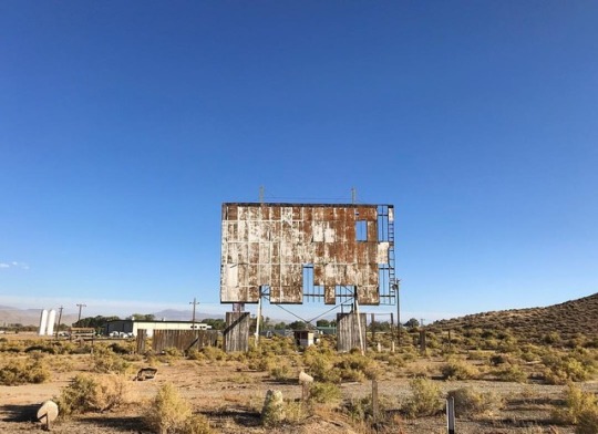
Abandoned Yerington Drive-In Theater, Yerington, NV. . . . . . . . . . . #landscape #nevada #DFMI #TravelNevada #nvmag #explorenevada #naturalnevada #nevadaliving #onlyinNV #DiscoverNV #alltrails #modernoutdoors #roamearth #rediscovertheearth #ViewBug #earthfocus #TLPicks #OurPlanetDaily #lonelyplanet #lpfanphoto #landscapephotography #abandoned (at Yerington, Nevada) https://www.instagram.com/p/Bsb3aVPlsti/?utm_source=ig_tumblr_share&igshid=1ruuzdlid529n
#landscape#nevada#dfmi#travelnevada#nvmag#explorenevada#naturalnevada#nevadaliving#onlyinnv#discovernv#alltrails#modernoutdoors#roamearth#rediscovertheearth#viewbug#earthfocus#tlpicks#ourplanetdaily#lonelyplanet#lpfanphoto#landscapephotography#abandoned
42 notes
·
View notes
Conversation
U.S. Daily Precipitation Records Tied/Broken 9/21/22
Unincorporated Copper River Census Area, Alaska: 1.18" (previous record 0.6" 2019)
Unincorporated Southeast Fairbanks Census Area, AK: 0.4" (previous record 0.3" 2021)
Baker Butte summit, Arizona: 0.7" (previous record 0.2" 2004)
Canyon De Chelly National Monument, Arizona: 0.2" (previous record 0.16" 1990)
Coconino National Forest, Arizona: 0.8" (previous record 0.3" 1991)
Coronado National Monument, Arizona: 1.69" (previous record 1.51" 2015)
Kaibab National Forest, Arizona: 0.7" (previous record 0.1" 2021)
Lost Dutchman State Park, Arizona: 0.35" (previous record 0.31" 1988)
Mormon Mt. summit, Arizona: 0.7" (previous 0.2" 1994)
Prescott, Arizona: 0.58" (previous record 0.27" 1952)
Sitgreaves National Forest, Arizona: 0.9" (previous record 0.2" 1994)
Tempe, Arizona: 0.17" (previous record 0.12" 1994)
Tonto National Forest, Arizona: 0.45" (previous record 0.44" 1933)
Chico, California: 0.01" (also 0.01" 1930)
Ebbetts Pass summit, California: 0.9" (previous record 0.8" 2017)
Eldorado National Forest, California: 0.7" (previous record 0.5" 2017)
Unincorporated Lassen County, California: 0.6" (previous record 0.32" 1953)
Unincorporated Napa County, California: 0.38" (previous record 0.07" 2013)
Unincorporated Nevada County, California: 0.24" (previous record 0.19" 2004)
Unincorporated Solano County, California: 0.06" (previous record 0.02" 2007)
Stanislaus National Forest, California: 0.2" (also 0.2" 2017)
Trinity National Forest, California: 0.4" (previous record 0.11" 2017)
Winters, California: 0.09" (previous record 0.02" 2007)
Unincorporated Costilla County, Colorado: 1.3" (also 1.3" 2006)
Unincorporated Costilla County, Colorado: 1.5" (previous record 0.8" 2006)
Cumbres Pass summit, Colorado: 1.2" (previous record 0.9" 1997)
Unincorporated Lake County, Colorado: 0.36" (previous record 0.31" 1952)
Unincorporated Las Animas County, Colorado: 1" (previous record 0.9" 1995)
Kissimmee, Florida: 2.12" (previous record 1.67" 1948)
Bitterroot National Forest, Idaho: 0.2" (previous record 0.1" 2006)
Malad City, Idaho: 0.78" (previous record 0.7" 2017)
Shoshone, Idaho: 0.3" (also 0.3" 1945)
Targhee National Forest, Idaho: 1" (previous record 0.6" 2008)
Cawker City, Kansas: 1.32" (previous record 1.17" 1985)
Beaverhead National Forest, Montana: 1" (previous record 0.8" 1984)
Centennial Mountains Wilderness Study Area, MT: 1.2" (previous record 0.6" 1997)
Deerlodge National Forest, Montana: 0.3" (previous record 0.2" 2008)
Unincorporated Douglas County, Nevada: 0.41" (previous record 0.2" 2013)
Unincorporated Pershing County, Nevada: 0.24" (previous record 0.03" 1998)
Slide Mt. summit, Nevada: 0.2" (also 0.2" 1985)
Toiyabe National Forest, Nevada: 0.5" (also 0.5" 2017)
Yerington, Nevada: 0.23" (previous record 0.02" 1988)
Greenville, New Hampshire: 0.18" (previous record 0.11" 1997)
Carson National Forest, New Mexico: 0.4" (previous record 0.3" 2021)
Gallup, New Mexico: 0.73" (previous record 0.4" 1997)
Unincorporated San Miguel County, New Mexico: 0.6" (previous record 0.59" 1947)
Arbuckle Mt. summit, Oregon: 0.2" (also 0.2" 1983)
Big Red Mt. summit, Oregon: 0.7" (previous record 0.4" 2013)
King Mt. summit, Oregon: 0.4" (previous record 0.2" 2013)
Malheur National Forest, Oregon: 0.3" (previous record 0.1" 1991)
Whitman National Forest, Oregon: 0.6" (previous record 0.3" 1986)
Willamette National Forest, Oregon: 0.3" (also 0.3" 2000)
Winema National Forest, Oregon: 0.25" (previous record 0.03" 1980)
Cache National Forest, Utah: 0.6" (previous record 0.5" 1984)
Dixie National Forest, Utah: 1.8" (previous record 0.8" 2014)
Fishlake National Forest, Utah: 0.5" (previous record 0.4" 2014)
Unincorporated Garfield County, Utah: 2.32" (previous record 1.26" 1952)
Manti-La Sal National Forest, Utah: 0.4" (also 0.4" 2014)
Scipio, Utah: 0.8" (previous record 0.3" 1917)
Uinta National Forest, Utah: 0.6" (also 0.6" 2014)
Wasatch National Forest, Utah: 0.9" (previous record 0.6" 1998)
Widtsoe Peak summit, Utah: 1.7" (previous record 0.8" 2014)
Bridger National Forest, Wyoming: 0.6" (previous record 0.5" 1984)
Triple Peak summit, Wyoming: 0.5" (also 0.5" 2006)
#Storms#U.S.A.#U.S.#Arizona#1980s#1990s#1930s#1950s#Florida#1940s#Idaho#Kansas#Nevada#New Hampshire#New Mexico#Oregon#Utah#1910s#Alaska#Colorado#Wyoming#Montana#Crazy Things#Awesome
0 notes
Text
YOU GUYS. IM BACKKKKKKK
No I never forgot about serendipity says yes I’m restarting it and yes here are the first 160 words:
I roll down the window and breathe, sucking in the sultry Nevada air. Actually, we might not even be in Nevada anymore. I don’t know. But one thing’s for sure: we aren’t in Yerington.
We’ve been on the road for two and a half days now. I like to think of it as a getaway of sorts. A vacation. Who wouldn’t jump at the chance of disappearing with their best friend, with nothing else but the sun and sky and open road? Personally, I would have never imagined us actually doing it. We’ve talked about it, sure, but not in the way that means you’re serious about something. More in a, “when we grow up and make tons of money and travel the world,” kind of way. It’s almost funny how we ended up here – seventeen, fugitives, and no idea where we’re even traveling to, if you could call it that.
Actually, Leslie’s not a fugitive, I am. But whatever. Technicalities.
0 notes
Photo
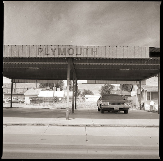
Plymouth
Hasselblad Yerington, Nevada
On Flickr
© Eben Ostby June 20, 2019 at 07:31AM. All rights reserved
2 notes
·
View notes
Photo
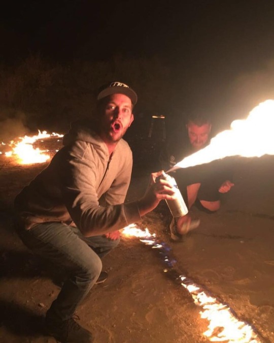
Light Em Up 🔥 (at Yerington, Nevada) https://www.instagram.com/p/Bo71Lb4nG_LLNWU9uBVmspf0DH9TfmBv2JcE6c0/?utm_source=ig_tumblr_share&igshid=nffvp0tbh5o6
1 note
·
View note
Last Seen Blogs

pilingexpert
Untitled

wunderlands-grinsekatze
Die ganze Welt schien zu pulsieren wie ein Bass

olsen69olsen
The Love of Beatty 936

malecprscene
Cpr male

levitatingzz
jenni