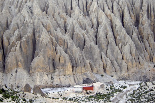
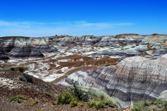
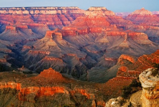
#badland topography
Photo

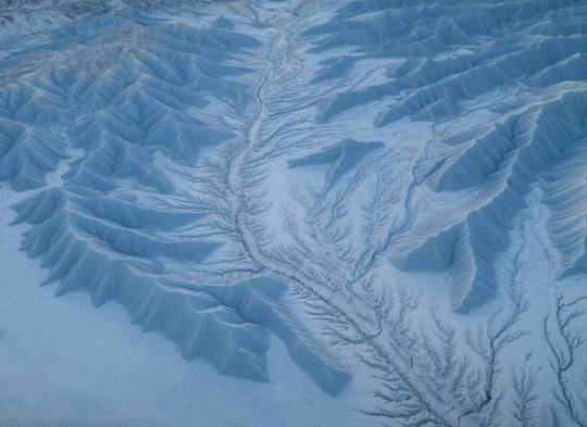
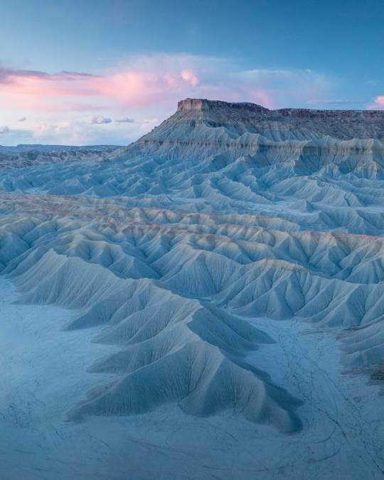
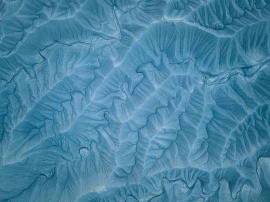
Aerial Photos Highlight the Rugged, Textured Topographies of the American Badlands
All images © Tobias Hägg

#tobias hagg#photographer#aerial photography#drone photography#topographies#american badlands#nature#landscape
33 notes
·
View notes
Text
Let's Talk About BENTONITE
There's nothing worse than minding your own business, walking along in the desert when all of a sudden your feet start to feel weighted down. It gets harder and harder to pick up your feet. The mud is sticky and pulling you into the ground. That's bentonite.

Bentonite is type of very soft, plastic clay made primarily of montmorillonite clay.
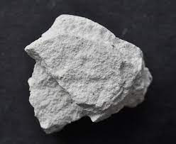
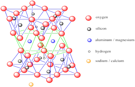
Montmorillonite is a hydrous, aluminum silicate in the smectite group (often you will hear bentonite and smectite used interchangeably).
Bentonite is formed by the alteration of volcanic ash when it comes in contact with water. Clays in general form from the chemical breakdown of feldspars (check out October's posts for more on feldspar!) and when ash gets thrown in the mix something very nasty occurs: swelling clays.
Bentonite increases greatly in volume when water is added...and decreases just as much when the water evaporates or gets absorbed in the groundwater system. This causes the popcorn texture you see in badlands topography.

Popcorn texture in Brushy Basin Member, Morrison Formation, near Evil Tree Bonebed. Sauropod rib found in it.
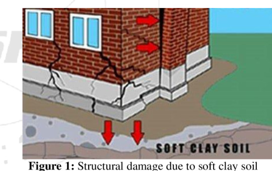
This can also cause structural damage. That is why the building around the Wall at Dinosaur National Monument had to be repaired a few years ago. Basically, the swelling of the bentonite split the foundation.
It also becomes very dangerous to drive on or walk on when it gets wet, becoming a slurry, sticky mess.
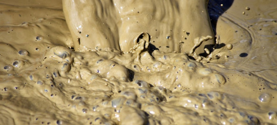
This is the main reason why we have to wait for summer to come before we head out to the dig site. We physically cannot get there until the Mancos Shale bentonite is dry enough to drive on.
Bentonite is not all bad though. It has some good uses too.

We actually use it to trap moisture in our skin and hair when we dry out. It's a natural sunblock and relieves burns and itching from bug bites. We even put it in Wendy's Frosty's to give them that smooth texture!

Bentonite is also used in agriculture as a natural pesticide, herbicide, and fungicide in fertilizers.
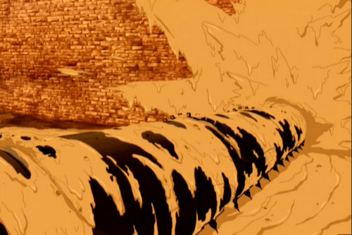
They also use it to coat drills in the oil industry to keep the drill bit lubricated, as well as coating well walls to keep them from collapsing. If you're a geek, like me, think Avatar, the Last Air Bender and the Fire Nation drill.
Hope you learned a little about bentonite today! Fossilize you later!
54 notes
·
View notes
Text
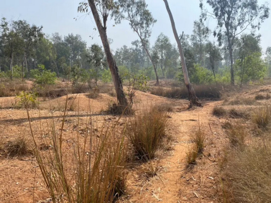
The “khoai” is the name colloquially given to [...] landmasses in and around the Chotanagpur Plateau in eastern India. Rich in iron oxide, these [...] soils are marked by a rugged and often undulating topography, resulting from millennia of erosion from monsoon rains, the many winding rivers that populate the region and action of winds from summer thunderstorms, popularly termed in Bengali as “Kalboishakhi.” The winds and the rains of the kalboishakhi dance across the lands adjoining the Bay of Bengal, often arriving at the horizon with ominous dark clouds right before sunset. [...]
The khoai is a charismatic frontier in an ongoing conversation within South Asian developmentalist imaginaries that call for optimal land use for the purposes of economic growth. [...] As the lateritic soil of the region is not suited for intensive agriculture, efforts have been made to make vast sections of the region arable [...]. And so, slowly, the red soils get taken over the green [...]. This is often done by breaking gullies and hoodoo-like structures [...] to flatten the lands [...]. The ongoing project to turn such “deserts” green has a long history. Yet alongside these projects, is the place that the khoai have in the literary, cultural, and spiritual imagination of many [...] that inhabit the Chotanagpur Plateau. The vastly open and hilly topography, dotted with sal forests [...] has often been the fodder for songs of longing [...]. The horizon of the sky meeting the red gullies of the badlands also form many a narrative that appear in local folk songs and stories. [...] They have also been sites of community-based agroforestry.
---
Recently, such badlands have been termed unproductive in and around my hometown of Santiniketan, India.
As South Asian developmental imaginaries wholly absorb the understanding of terra nullius from modern Euro-American conceptions of land, the idea that “badlands” are necessarily “wastelands” become cemented. Once beloved [...], the dark brown-red hoodoos and gullies today are seen as wasted potential that are depriving the public of much-needed resources, and the possibility of the coming of civilization in accordance with upper-caste aspirations. Khoai today have become sites for proposed plantations facilitated by local forestry authorities, holiday homes and cafes [...], luxury resorts [...].
The ethos of invoking terra nullius has travelled into discourses surrounding “practicality” and the absolute necessity for villagers and small town folks in the area to be saved by their urban-dwelling upper caste counterparts [...] who are interested in their cultural practices, seemingly idyllic agricultural lifeways and the simplicity away from the stresses of cities such as Kolkata. But in this framework, the imaginaries of development are necessarily embedded in compulsory extraction, whether that be of cultural economies, minerals, timber, or land for development. [...]
[B]adlands get turned into places that need saving from being “wasted” by the carelessness and unimaginative shortsightedness of villagers and Adivasis, who are simply seen as ill-equipped to deal with the progression of the global economy.
These days, it is hard to find a piece of the “khoai” that has not been subjected to projects of agriculture, forestry, or have been subjugated to [...] property ownership [...]. As the figures of the plantation and its attendant cultures of enclosure and theft of commons creep into places previously overlooked by the tentacles of global extractive forces, many, if not most khoai areas are mobilized to be “redeemed” into productive little plots legible to capital.
I have to wonder about the processes of consent and negotiation that have informed such projects. [...] These areas were in the past predominantly inhabited by Adivasis or Indigenous peoples of India, who had resisted the [...] hierarchies [...].
Badlands such as the “khoai” present a challenge to capitalist imaginaries because they defy its temporalities and its compulsion to make all aspects of being productive and legible to exchanges that foster logics of uninhibited growth. [...]
What, then, does it mean to care for wastelands? [...]
What histories are paved over by concrete? What does development mean in places where inequality is still rife, but there are shiny new roads? What does a future look like, where we can let badlands and “wastelands” just be, as part of ecological and cultural commons?
---
Text by: Aadita Chaudhury. "Caring for Badlands". The Otter, Network in Canadian History and Environment (NiCHE). Emotional Ecologies series. Ed. Jessica M. DeWitt and Sarah E. York-Bertram. 14 July 2023. [Photography by Aadita Chaudhury, included in the original article. Bold emphasis and some paragraph breaks/contractions added by me.]
101 notes
·
View notes
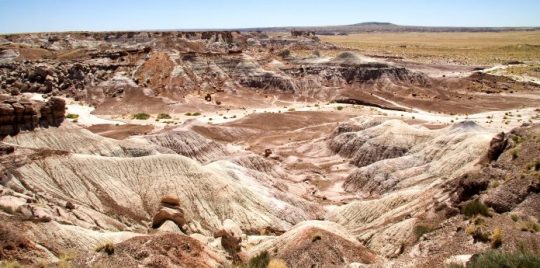
Photo


Aerial Photos Highlight the Rugged, Textured Topographies of the American Badlands
946 notes
·
View notes
Text
Badlands are characterized by a distinctive badlands topography.
okay so theyre an actual. ecology? thing and not just like. derogatory slang. but still. wheres he live oh the badlands? well im sure its lovely out there.
7 notes
·
View notes
Video
flickr
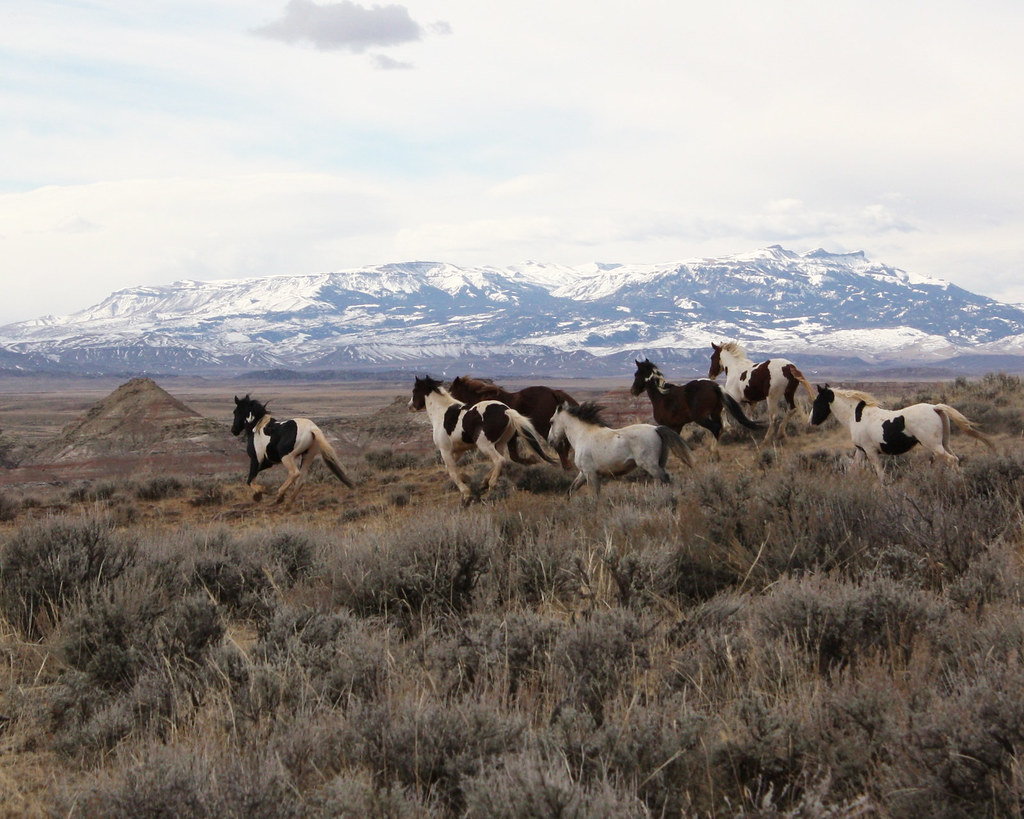
McCullough Peaks HMA 2 - Cody Field Office by BLM Wyoming
Via Flickr:
The McCullough Peaks Wild Horse Herd Management Area (HMA) is located 12 to 27 miles east of Cody (70 miles east of Yellowstone National Park) and encompasses 109,814 acres of land, including the McCullough Peaks Wilderness Study Area. The climate is typical of a cold desert with annual precipitation averaging five to nine inches. Stock reservoirs and intermittent streams fed by winter snows and spring runoff provide adequate water for the HMA. Topography is highly variable, ranging from mostly flat to slightly rolling foothills carved by drainages, to colorful badlands and desert mountains featuring steep slopes, cliffs and canyons. A diversity of coat colors (bay, brown, black, sorrel, chestnut, white, buckskin, gray, palomino, and blue, red and strawberry roans) and patterns such as piebald and skewbald are found in the McCullough Peaks wild horses. The animals tend to be moderate- to large-sized and habitat conditions are such that the horses are in very good condition. The combination of size, conformation, coat colors and patterns, and excellent physical condition have become a draw for potential adopters and a matter of reputation for McCullough Peaks horses. Be sure to bring your binoculars and always look on both sides of the roads for both the mustangs and other wildlife! DIRECTIONS Travel east from Cody on Highway 14-16-20 to mile marker 72 (about 18 miles). On the left you will see a gate; horses are often in this area and you can enter if you choose. If not, continue to near mile marker 74 where you will see a kiosk and the Whistle Creek road sign on your left; enter, proceed to pipeline marker 75 (about 6 miles) and enjoy the remarkable panoramic view of the badlands. LATITUDE / LONGITUDE 44.4634, -108.6388 PHONE 307-578-5900 EMAIL [email protected] www.blm.gov/visit/mccullough-peaks-wild-horse-herd-manage...
28 notes
·
View notes
Text
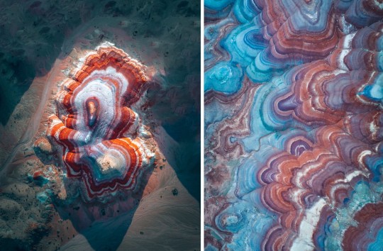
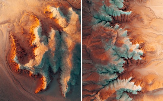
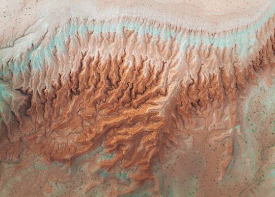
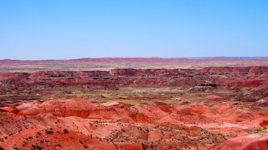
Aerial Photos Highlight the Rugged, Textured Topographies of the American Badlands
September 30, 2022
ThisIsColossal.com
Grace Ebert
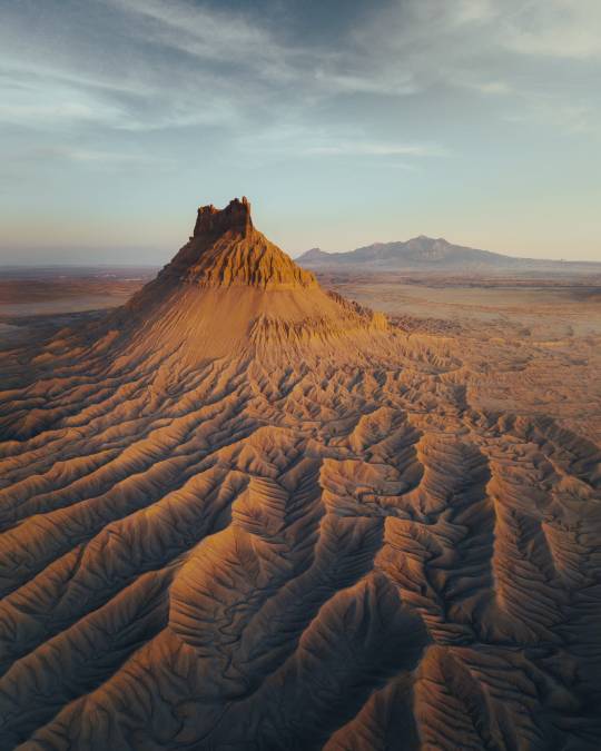
All images © Tobias Hägg, shared with permission
Awash in pale blue light or the glimmers of dusk and dawn, the dry, eroded terrains of the American West appear as otherworldly vistas in the works of Stockholm-based photographer Tobias Hägg (previously). Captured in spring of this year, the aerial images peer down on or out across the vast, rugged landscapes known as badlands. These regions are replete with geological formations and terrain diversity, and Hägg spotlights such shifts in elevation and soil by documenting the rippling, ravine crevices and buttes that overlook the area. Light and shadow dramatize the images and accentuate the textures and depth of the extraordinarily craggy topographies.
Prints of Hägg’s images are available in his shop, and you can find more from photographer, including new a forthcoming book comprising a decade’s worth of work, on Behance and Instagram.


0 notes
Text

On Duty - Day 1, Trailbreaker Week 2021!
Teebs, Hound and the Twins on patrol in the southwest! 🏜☀️🧡 @teebsweek
#i rly wanna make this into a print or smth#i just love drawing these guys#patch.art#teebsweek2021#trailbreaker#hound#sunstreaker#sideswipe#arizona#gully topography#badland topography#geology#transformers#maccadam#traditional art
43 notes
·
View notes
Text
I'm not letting myself write it yet cuz i have to finish Flesh and Blood first. But I have this AU idea that I'm going to make into a Velvetfrost oneshot that uses the concept of a world whose topography is based on a giant skeleton half-sunk in the ground. Its bones are the terrain, and various cities reside in different parts of the body. Dreamlands is carved into the back of its skull, the twin cities of L'Manburg and Manburg sit opposite each other on two massive shoulderblades, and past the range of the massive spine you will find the Badlands, built on the plains between two massive femurs.
And there's the ribcage of course, the curving bones surrounding a massive cavern no one dares to go into. Anyone making the journey down the spine will spy, far below, the darkness and the choking greenery that fills the underground. If you fall in, you're as good as dead.
That's what Ant thinks will happen when he falls. Thankfully, there's a stranger willing to lend him a helping hand.
6 notes
·
View notes
Photo

Aerial Photos Highlight the Rugged, Textured Topographies of the American Badlands
Photographer: Tobias Hägg

47 notes
·
View notes
Photo
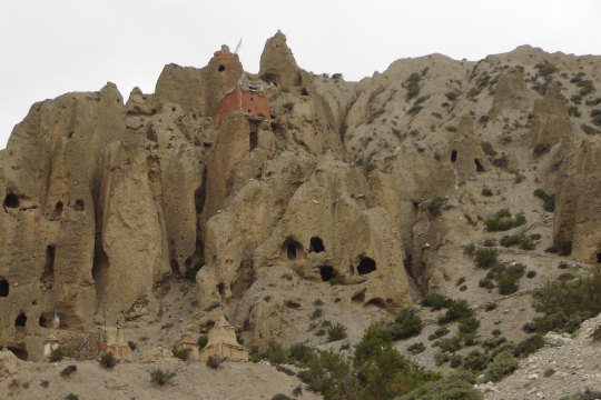
Luri Gompa
This spot is found in the Kali Gandaki river valley, high in the Himalayas near Marpha, in the Mustang district of Nepal which is bordered by the giant peak Annapurna.
This river valley is filled with fairly recent, soft, coarse-grained sediments. At some point in recent geologic history, the valley that is now being cut by the river was being filled with sediment; maybe because the valley was dammed by a landslide, maybe because more sediment was being delivered due to erosion by glaciers.
Those soft sediments are rapidly eroding, creating this badlands-style topography. Humans have also taken advantage of these weak layers, as several thousand caves have been carved into the loose layers. Humans may have been using some of those caves for thousands of years, and several of them including Luri Gompa have been used as Buddhist temples. That particular site sits on a pillar of sediment, a barrier to all but the heartiest of climbers, and contains a variety of artwork depicting Buddhists believed to have obtained great powers through meditation.
-JBB
Image credits: Bob Witlox
https://flic.kr/p/3nE3QB
https://flic.kr/p/3nJxfd
Reference:
https://www.amusingplanet.com/2016/03/the-mysterious-caves-of-mustang-nepal.html
#geology#sediment#conglomerate#mustang#kali gandaki#himalayas#nepal#travel#river#erosion#luri gompa#buddhism#temple#the earth story
120 notes
·
View notes
Note
Having visited the various North American high deserts and spent time in them, I'm glad to see some love for them. Ecologically (and also linguistically tool) they're amazing places with both striking geography and complicated networks of things living there. To see them called barren is to miss the desert for the shrubbery. They're so unique and interesting. Loving the posts about them in detail. To see them through a camera lens is a joy every time.
thank you for the support, thank you for the message, and thank you for defending deserts.
i know that the “true” deserts (Sonoran, Mojave, Chihuahuan) do get a bit of credit/acknowledgement for their uniqueness and biodiversity, but i’ve spent much more time in and feel a lot of compassion for those relatively less-publicized “cold” deserts and semi-deserts (Columbia Plateau, Great Basin, Colorado Plateau, Wyoming Basin) and the aesthetically-similar (superficially at least?) shortgrass prairie and High Plains (eastern Montana, Wyoming, Colorado, etc.). big fan of badlands and sagebrush steppe. “drably-colored” shortgrass prairie or the apparent basin-and-range repetition of topography in Great Basin sagebrush steppe might visually appear “simple,” but whatever. aside from the true deserts of the Southwest, even the cold deserts farther north aren’t without their own endemic vertebrates despite winter cold (some of my favorites include the adorable pygmy short-horned lizard in Columbia Plateau and high-elevation slopes in rain shadow of East Cascades; pygmy rabbit in Great Basin; blotched tiger salamander in Missouri River Plateau badlands; the rare dunes lizard endemic to a very small distribution range in the shinnery-oak sand dunes of Llano Estacado; and the beautifully-colored Crotalus concolor rattlesnake endemic to the canyonlands and pinyon-juniper of the Colorado Plateau, etc.)
even setting aside the “obvious” biodiversity and really cool altitudinal zonation of the Sky Islands, the Sonoran Desert alone is just ... teeming with life, most of it endemic and superlative. so that, even by standards of typical extractivist settler-colonial vision which seems inclined to glorify only the superlative, it’s still hard to ignore the Gila monster, saguaro, rosy boa, etc. (shout-out to jaguar, ocelot, thick-billed parrot, and imperial woodpecker on the periphery of the Sonoran Desert. by the way, i was just reading a lot this week about a “new” cryptic species of desert tortoise from Sinalonan thornscrub. and recently, the Boa constrictor living in western Mexico and on the periphery of the Sonoran Desert was determined to be a unique species. also, American crocodiles lived in the Rio Yaqui in the Sonoran Desert in recent centuries, and still showed up in the desert on the shores of Isla Tiburon into the 1970s!)
shaking my head at the irony of the widely-reproduced term “Great North American Desert” famously being ascribed to the shortgrass prairie of the northern Great Plains (despite the place not being a “desert” ecologically).
and then of course the nightmares.
the history of wastelanding; metals mining; border policing; uranium poisoning in Navajo country and the Colorado Plateau; cattle rangeland and overgrazing, especially in Chihuahuan Desert grasslands along the Rio Grande and Pecos; Indigenous dispossession generally; nuclear bomb testing and fallout raining down upon Navajo, Hopi, Ute, Pueblo people; the absurd amount of water stolen from the Colorado River to sustain Las Vegas; political border infrastructure separating Tohono O’Odham communities; manicured non-native grass lawns in Phoenix; recreationists destroying Joshua trees in the Mojave just for fun; the construction of H**ver Dam and Lake Foul; cattle in northern Great Basin; the conversion of the canyons and coulees of the Snake River Plain landscapes into monoculture extraction sites; the complete destruction of the Colorado River Delta and resulting inevitable extinction of the world’s smallest porpoise in the Gulf of California
so much life in these deserts, and so much of it targeted for elimination
30 notes
·
View notes
Photo


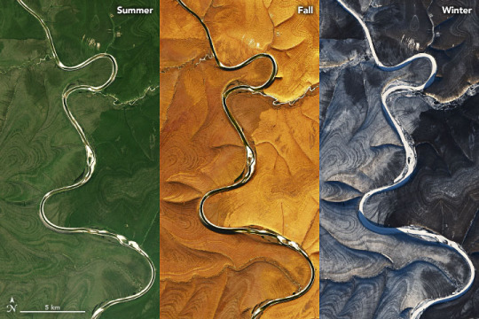

From Russia with Questions Earth science satellites are generally used to observe certain features of the planet—landforms, atmospheric chemistry, ocean patterns. But at the same time, they periodically show us things that few people have seen or even looked for. In February 2020, our team noticed a twitter message with a peculiar and beautiful image from Russia near 66 degrees north latitude. It turned into a scientific detective story and an unresolved case. In the images above and below, acquired by the Operational Land Imager (OLI) on Landsat 8, stripe patterns twist and turn around the hills of the northern Central Siberian Plateau. On steeper hills, the stripes form tight loops that spiral from the top of the hill to the bottom. As they descend toward the riverbanks, they start to fade. Eventually, the stripes disappear at lower elevations and at latitudes. There are several possible causes for the distinctive striping pattern, and the answers vary by the season and by the expertise of the researcher. This portion of the Central Siberian Plateau lies within the Arctic Circle, where air temperatures remain below freezing for most of the year. Much of the landscape is covered in permafrost that can stretch tens to hundreds of meters below the surface. There are different levels of intensity, but this area generally has permafrost coverage for 90 percent of the year. The land does occasionally thaw, and cycles of freezing and thawing are known to create polygon, circle, and stripe patterns on the surface (referred to as “patterned ground”). In the case of the images above, the stripes could be elongated circles stretched out on the slopes by such thawing cycles. Yet studies have shown that this type of striping usually occurs at a much smaller scale and tends to be oriented downslope. To geomorphologists, the nature of the soil offers another explanation for the stripes. In regions this cold, soils can turn into Gelisols—soils with permafrost in their top two meters and often with darker and lighter layers distinguished by more organic matter or more mineral and sediment content. As the ground freezes and thaws, the layers break up and mix vertically in a process called cryoturbation. The persistent freezing and thawing action through the seasons can cause layers to align in a striping pattern. Different tundra vegetation—lichens, low shrubs, and moss—might grow preferentially on these Gelisol layers, accentuating the stripes we see from above. But this hypothesis has not been proven at large scales. From a geologist’s perspective, the different stripes appear similar to sedimentary rock layers. Thomas Crafford of the U.S. Geological Survey called the pattern “layer cake geology,” where sedimentary rock layers have been exposed and dissected by erosion. As snowmelt or rain travels downhill, pieces of sedimentary rock are chipped away and sent down to the ravines below. Such erosion could cause a step-like pattern that appears as stripes from space similar to a slice of layer cake. This pattern is also referred to as “cliff and bench topography.” In the winter Landsat image at the top of the page, snow causes the striping pattern to stand out more than in other seasons. The benches would be the lighter stripes (covered in snow) and the cliffs would be darker stripes. The Arctic digital elevation map above, based on data from the ArcticDEM Project, gives a clearer perspective on the possible cliff and bench features. “It looks like small canyons, maybe like the Badlands of South Dakota. The horizontal striping appears to be different layers of sedimentary rock,” said Walt Meier, an ice specialist at the U.S. National Snow and Ice Data Center. “The shape of the erosion pattern looks a bit different than standard sedimentary erosion, but my guess is that is due to the permafrost. The rivers are eroding through frozen ground. There could also be some effect from frost heaves affecting the topography.” Several rivers cut across the plateau, including the Markha, and as the stripe pattern moves closer to the river, it starts to fade. This could be a result of sediment buildup along the riverbanks from millions of years of erosion. Louise Farquharson, an Arctic geologist at the University of Alaska-Fairbanks, pointed to a region in northern Alaska with a very similar stripe pattern that could be formed by a similar process. NASA Earth Observatory images by Joshua Stevens, using Landsat data from the U.S. Geological Survey and topographic information from the ArcticDEM Project at the Polar Geospatial Center, University of Minnesota. Story by Andi Brinn Thomas, with Mike Carlowicz.
3 notes
·
View notes
Text
Behind the Scenes with the Baron de Bayet and L. W. Stilwell Collection Part 3: The Wild West Formed Million of Years Ago
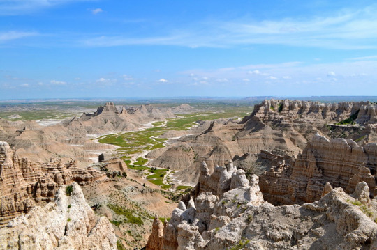
Figure 1: Badland National Park Today, National Park Service photo, 2014. This view of the Badlands topography illustrates the erosion that took place over the last 2 million years.
The Lakota called the badlands “Mako Sica” or “land bad.” The early French-Canadian trappers referred to it as “les mauvais terres pour traverse” or “bad lands to travel through.” Seventy-five million years ago, this area was a lush underwater seaway filled with creatures such as mosasaurs, plesiosaurs, diving birds, fish, baculites, and ammonites (Figure 2).

Figure 2: Taxa that swam in the Western Interior Seaway from Dinosaurs In Their Time exhibit at Carnegie Museum of Natural History. Photo by Patty Dineen.
The Stilwell fossils of Cretaceous age (Figure 3) were deposited in a black mud that accumulated on the sea floor from 82 to 70 million years ago (Figure 4). The Pierre Shale is part of the extensive Western Interior Seaway of North America (Figure 5). Museum visitors can view a changing geographic representation of the seaway on a wall-mounted flat screen monitor within the Dinosaurs in Their Time exhibit. The seaway extended from the Gulf of Mexico, Florida, and southern Gulf Coast, north through Texas, Kansas, Colorado, Wyoming, Montana, the Dakotas, and the Canadian Provinces of Alberta and Saskatchewan. This vast waterway terminated in the Artic region of Canada. At the time of the Pierre Sea, the ice sheet-free greenhouse to hothouse paleoclimate was much warmer than it is today, creating the highest sea levels in earth’s history. Sea level rises and falls were primarily controlled by the presence or melting of glaciers in the polar regions, the shifting of the continents, and the uplifting of proto-Rocky Mountains by plate tectonics.
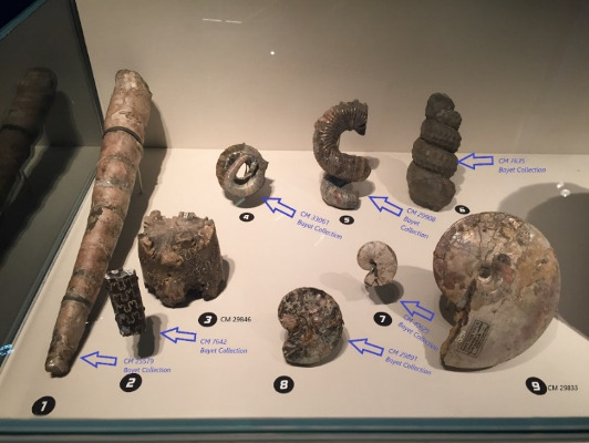
Figure 3: Western Interior Seaway fossils on display at Carnegie Museum's Dinosaurs in Their Time exhibit. Stilwell fossils are highlighted in blue.

Figure 4: Outcrop photo of Pierre shale.

Figure 5: Western Interior Seaway approximately 75 million years ago. Red dot locates Deadwood, South Dakota today.
Fast forward to the Wild West of the 1890’s, and dealers such as Stilwell found and sold fossils to museums and private collectors. Knowledge of Badlands fossils spread as far as Europe, and by 1889 Bayet wanted some for his own collection.
Next, in our final post of this series, we will delve into the Stilwell-Bayet correspondence in search of clues about how fossils were bought and sold over a century ago.
Joann Wilson is an Interpreter for the Department of Education and a volunteer with the Section of Invertebrate Paleontology. Albert Kollar is Collections Manager for the Section of Invertebrate Paleontology. Museum employees are encouraged to blog about their unique experiences and knowledge gained from working at the museum.
#Carnegie Museum of Natural History#Baron de Bayet#Invertebrate Paleontology#Paleontology#Wild West#LW Stilwell
22 notes
·
View notes
Text

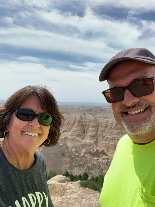
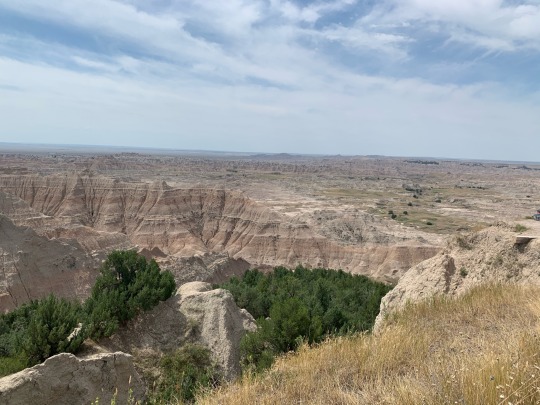
We’re at Custer State Park. Yesterday on our way here we stopped to see Dignity, she is so beautiful. She is at a rest stop on I90 that was on a bluff overlooking the Missouri River. We also stopped at the Badlands National Park which has amazing topography.
1 note
·
View note
Text
Cool! Thank you!😁❤️❤️❤️❤️
The magical colors of painted desert Arizona
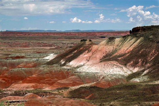
The Painted Desert is a badlands in the Four Corners area running from near the southeast into Petrified Forest National Park and east of Grand Canyon National Park. But it is easily accessed in the north side of Petrified Forest National Park. The brilliant and varied colors include more common red rock and shades of lavender. It took millions of years for nature to form this natural canvas of unbelievable design that some describe it as a multi-colored layered cake.
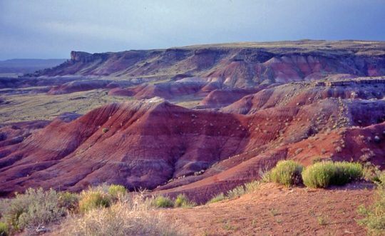

The Painted Desert was named by an expedition under Francisco Vázquez de Coronado on his 1540 quest to find the Seven Cities of Cibola. Hence, passing through the wonderland of colors, they named the area El Desierto Pintado “The Painted Desert”. The Petrified Forest and Painted Desert is a living history book. The majestic colors, hues, and shades paint a tapestry of time.

The most part of Painted Desert is protected as Petrified Forest National Wilderness Area. Nonetheless, the area is easy and longer hikes into the colored hills. The magical Painted Desert continues north into the Navajo Nation, where off-road travel is allowed by permit. Wind and rain, the sedimentary composition of the rocks and the lack of protective vegetative, all subsidize to the rapid erosion of the Chinle Formation.
Moreover, Painted Desert is composed of stratified layers easily erodible siltstone, mudstone, and shale of the Triassic Chinle Formation. The fine-grained rock layers comprise plentiful iron and manganese compounds that offer the pigments for the various colors of the region. Thin resistant lacustrine limestone layers and volcanic flows cap the mesas. Further, several layers of silicic volcanic ash occur in the Chinle and provide the silica for the petrified logs of the area. The erosion of these layers has resulted in the formation of the badlands topography of the region.
In the southern portions of the desert, the remains of a Triassic period coniferous forest have fossilized over millions of years. Wind, water and soil erosion continue to change the face of the landscape by shifting sediment and exposing layers of the Chinle Formation. An assortment of fossilized prehistoric plants and animals are found in the region, as well as dinosaur tracks and the evidence of early human habitation.

The towns of Cameron and Tuba City are two major settlements roughly from Cameron – Tuba City southeast to past Holbrook and the Petrified Forest National Park. The desert is about 190 km long by about 97 km wide, making it roughly 19,425 km2 in area.
The desert has a cold desert climate with hot, dry summers and cold, though virtually snow-free winters. The annual precipitation is the lowest in northern Arizona. In several places is lower even than Phoenix. Most area of Painted Desert is accessible only by foot or unpaved road through major highways and paved roads.
5 notes
·
View notes
Last Seen Blogs

perkinsparadise
Perkins Paradise

ili-ote
This Is My LilWorld

yiiinpledged
– — 韩 YIN.

narudi3018
Just Memes

gannagerr
Gannagerr