#eastriver
Text
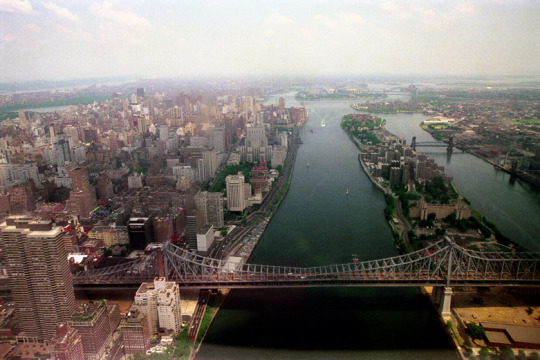
new york city
1976
aerial, over the east river
photograph by nick dewolf
https://www.flickr.com/photos/dboo/7353229720
#photography#film#color#35mm#newyorkcity#newyork#nyc#river#eastriver#bridge#bridges#city#manhattan#queens#rooseveltisland#island#buildings#aerial#1970s
23 notes
·
View notes
Photo
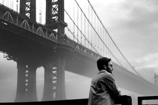
by wilkes.snaps
#nikon#z9#nyc#manhattan#river#fog#bridge#waterfront#blackandwhite#lowermanhattan#newyorkcity#eastriver#eastriverpromenade#manhattanbridge#flickr#thingsdavidlikes
4 notes
·
View notes
Photo
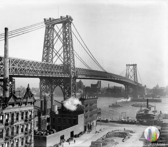
Williamsburg Bridge, 1903 The Williamsburg Bridge was the second bridge to span the East River following the Brooklyn Bridge almost two decades earlier and took half the time to build. By the time the bridge opened the independent city of Brooklyn had been consolidated into New York City. Compared to the neo-gothic towers of the #BrooklynBridge the public hated the steel towers of the Williamsburg Bridge when it opened. The 333-foot towers were originally designed to have a 140-foot tall spire atop each but were never constructed. The Bridge also featured a trolley terminal under #DelanceyStreet where streetcars going over the bridge would turn around. Streetcar service on the bridge was discontinued in 1948 and the terminal was shut down and lays abandoned to this day. The underground space was selected for the proposed #Lowline underground park, which features technology to reflect sunlight underground to grow plants. #williamsburg #brookyln #southwilliamsburg #nyc #dumbo #fortgreene #williamsburgbridge #manhattan #skyline #nychisory #nyhistory #urbanism #delanceystreet #brooklynbridge #manhattanbridge #nycphoto #eastriver #skyscraper #brooklynhistory #brooklynheights #nycurbanism (at Williamsburg Bridge) https://www.instagram.com/p/CgxJYYguUL3/?igshid=NGJjMDIxMWI=
#brooklynbridge#delanceystreet#lowline#williamsburg#brookyln#southwilliamsburg#nyc#dumbo#fortgreene#williamsburgbridge#manhattan#skyline#nychisory#nyhistory#urbanism#manhattanbridge#nycphoto#eastriver#skyscraper#brooklynhistory#brooklynheights#nycurbanism
45 notes
·
View notes
Photo
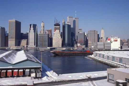

City as Metaphor
Lower Manhattan as seen from the Promenade in Brooklyn Heights, taken 1988 and 2021. Images by Richard Koenig; for more of this project please go here.
#manhattan#manhattan1980s#newyork1980s#filmphotography#grainisgood#rephotography#woolworthbuilding#eastriver#worldtradecenter#newgildedage#wtc#promenade#brooklynheights
34 notes
·
View notes
Text

October 21 2023
The City
1 note
·
View note
Photo
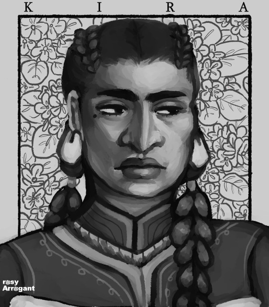
First set of my re-painted oc potraits, Kira Garber!
♥ comm info in pinned post & bio ♥
7 notes
·
View notes
Photo

3.2.23 Lunchtime drawing: Painting sometimes brings a moment of calm to an otherwise overwhelming kind of day. March edition from the roof of my studio building in the Brooklyn Navy Yard.
#nickslunchboxservice#brooklynnavyyard#shipyardcrane#drydock4#drydock#eastriver#brooklyn#sketchbook#watercolor#paintingaday
2 notes
·
View notes
Text
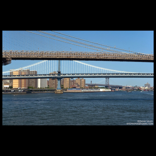
Three Bridges
Photography by David Velez
#newyork #nyc #davidvelez #david6of7 #photo #originalcontent
#eastriver #brooklynbridge #manhattanbridge #williamsburgbridge
#architecture
#Three Bridges#Photography by David Velez#newyork#nyc#davidvelez#david6of7#photo#originalcontent#eastriver#brooklynbridge#manhattanbridge#williamsburgbridge#architecture
8 notes
·
View notes
Photo
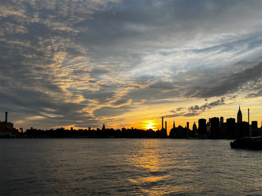
From across the river.
2 notes
·
View notes
Photo

Aerial footage of DUMBO Brooklyn, New York. Featuring: Downtown Brooklyn, Manhattan Bridge, Brooklyn Bridge, East River, Downtown Manhattan, Ferry,… The post Dumbo Brooklyn Bridge Sunset appeared first on JJ Social Videos. #DowntownManhattan #EastRiver #Drone #AerialFootage #Skyscrapers
0 notes
Text

new york city
1977
from the airplane window
photograph by nick dewolf
https://www.flickr.com/photos/dboo/50849043496
#photography#film#color#35mm#newyorkcity#newyork#nyc#river#eastriver#bridge#bridges#city#manhattan#queens#island#buildings#skyscrapers#twintowers#aerial#1970s
23 notes
·
View notes
Text

#Navalnaya
#NewYorkCity
#Manhattan
#EastRiver
#FreedomPlaza
#FieldOfLight
#BruceMunro
@bruce_munro
#BriceDailyPhoto
#Navalnaya#NewYorkCity#Manhattan#EastRiver#FreedomPlaza#FieldOfLight#BruceMunro#@bruce_munro#BriceDailyPhoto
0 notes
Photo
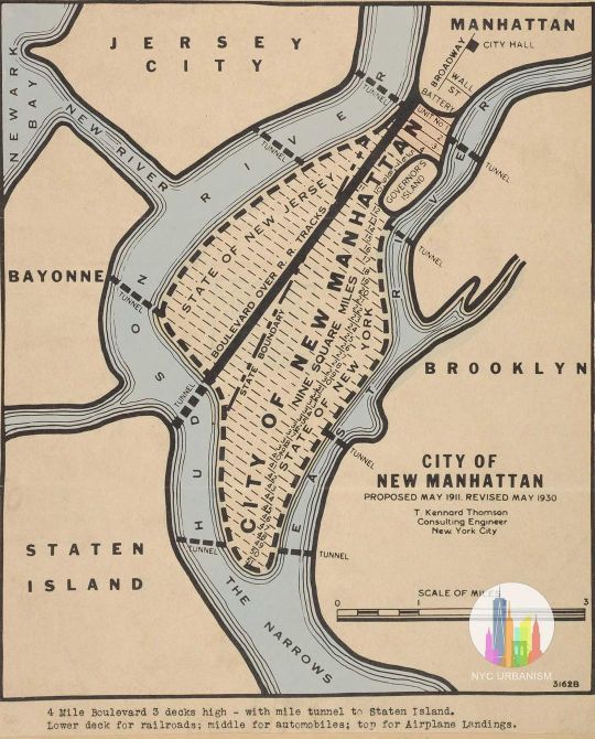
#MapMondays 1930 plan to fill New York Harbor with landfill! The proposal by T. Kennard Thomson was originally published in 1911 in Popular Science and would have filled the entire East River with landfill in addition to creating new peninsulas off of Staten Island, Bayonne and Sandy Hook, totaling fifty square miles! With the East River gone, Thomson proposed connecting the Long Island Sound back to the harbor by digging a new channel from Flushing through Brooklyn. Thomson revised the plan in 1930 (seen above), naming the new landfill City of New Manhattan, half of which would be in the state of New Jersey, separated by the extension of Broadway which would be a grand boulevard over railroad tracks flowing into a tunnel to Staten Island. This grand boulevard would be four miles long and three levels high, with trains, automobiles, and airplane landings! Tunnels would also go from Sunset Park to Bayonne, Red Hook to Jersey City, and Cobble Hill to Jersey City. #redhook #jerseycity #cobblehill #manhattan #nychistory #urbanism #longislandcity #queensny #statenisland #bayonne #eastriver #popularmechanics #civilengineering #brooklyn #dumbo #brooklynheights #tribreca #nyc #nyharbor #hudsonriver #longislandsound #urbanplanning #lowermanhattan #fidi #nycurbanism (at Governors Island) https://www.instagram.com/p/Cia2xlcOJP4/?igshid=NGJjMDIxMWI=
#mapmondays#redhook#jerseycity#cobblehill#manhattan#nychistory#urbanism#longislandcity#queensny#statenisland#bayonne#eastriver#popularmechanics#civilengineering#brooklyn#dumbo#brooklynheights#tribreca#nyc#nyharbor#hudsonriver#longislandsound#urbanplanning#lowermanhattan#fidi#nycurbanism
20 notes
·
View notes
Photo
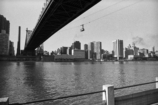
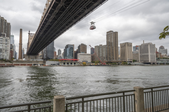
City as Metaphor
Manhattan as seen from Roosevelt Island, 1981 and 2021.
We're standing under the 59th Street, or Queensboro Bridge (now named for Mayor Ed Koch), looking over the East River toward Manhattan. The tramway is also here of course, though one can also get to the island via subway.
Images by Richard Koenig; for more of this project please go here.
#queens#queens1980s#manhattan#manhattan1980s#newyork1980s#filmphotography#rephotography#grainisgood#rooseveltisland#rooseveltislandtra#rooseveltislandtramway#eastriver#queensborobridge#59thstreetbridge
16 notes
·
View notes
Text
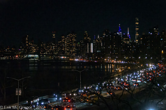
RUSH HOUR AT THE FDR (a week of nyc nightscapes) - Composition Monday
© Erik McGregor - [email protected] - 917-225-8963
#PhotoOfTheDay#RushHour#FDR#roadway#traffic#EastRiver#river#ManhattanSkyline#skyscrapers#NewYorkCity#NightSky#skyline#nightscape#cityscape#streetscape#UrbanLandscape#ILoveNY#WeLoveNYC#EastHarlem#Manhattan#NewYork#NYC#StreetPhotography#LandscapePhotography#UrbanPhotography#NightPhotography#ShotOnNikon#NikonPhotography#NikonD7500#Photography
1 note
·
View note
Last Seen Blogs


ianomatic
ianomatic
parroquialloaturismo
Lloa, Un Destino de Colores

naughtyboymichael
NaughtyBoyMichael

indohyus
Haunted Gay Radio