#fictional maps
Photo
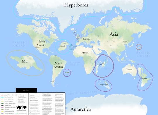
Mythical and Submerged land of the World.
by Breakingerr
3K notes
·
View notes
Text
The Kingdom of Yevsburg

This map shows Yevsburg's contiguous territory along the Dvenshev sea, and some of the major cities, roads, and rivers within it.
Bullet points on Yevsburg:
Ansuro is the national capital.
Most of the population is in the northwest, along the Dvenshev and surrounding Ansuro.
The south is covered in dense forests, making it a difficult place to live in.
Yevsburg is equatorial, with the equator being shown as the more prominent line. While it does receive high amounts of rainfall, equatorial regions on Hessdalen are not as warm as on Earth.
The Russo family has been the reigning royal house for hundreds of years, beginning with their construction of Fort Ansuro.
Yevsburg has numerous overseas territories, from the other side of the Dvenshev to Rosnen and the Kythelons.
Yevsburg shares a land border with Osbac, Gurngeshia, Rusland, and Torqnia in Rosnen.
Yevsburg controls the Strait of Julshev, the only way in and out of the Dvenshev Sea. It lost control of this opening to Gurngeshia during that country's war with Montethé.
Yevsburg was once known as Rusovia, and under that name ruled one of the largest and most influential empires in Hessdalanian history.
Tekov's Eyes, a naturally occurring marble like object that possesses explosive capabilities, originate in Yevsburg and were utilised for Rusovia's expansion.
Yevsburg is a member of the Trans-Continental Alliance.
Flag of Yevsburg

13 notes
·
View notes
Text

Some of the maps for my TTRPG project. I decided to air on the side of caution and make them more plain, but still readable.
9 notes
·
View notes
Photo
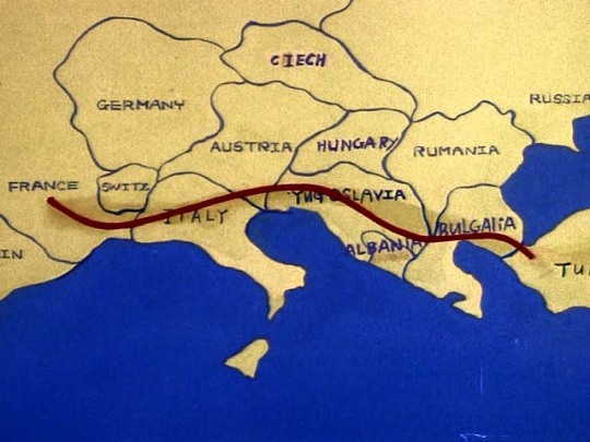
In the G1 episode “Trans-Europe Express”, we are given this incredible map of the Europa 2000 race.
Now, I don’t often call out animation fuck-ups, especially not relatively minor ones or one-off errors; Especially in the 80s, it’s just a fact of the way these shows got made that you’re going to have errors at a much higher incidence rate than any modern animation, for a lot of different reasons.
But I love this map. LMAO
Spelling Words Good, or Not: Language is, in fact, difficult
I don’t know which element of it is my favourite; I like how the slight shadow on the misspelled “I” in “Ciech” seems to suggest that it was spelled another way before they rubbed it out on the cel and then wrote over it with another letter.
Which means that there is a non-zero chance that at some point, it may have been spelled at least somewhat more correctly, but then made incorrect in someone’s self-doubt around their spelling skills.
Special shout out to “Rumania”, which historically was actually a correct spelling of Romania in English for quite a while-- Just not in the 80s when they were making the show! :’)
I can understand having a hard time trying to draw an outline of Europe if you have about 15 seconds to get a cel done and just have to put it through to get the show made, but the spelling is something that could have likely been checked in a dictionary or encyclopaedia (this was the 80s, so no Wikipedia yet) fairly easily-- But that’s assuming they had one nearby, and had the time to mess with it if they did.
(I’m aware that some studios/individuals did have a stray dictionary floating around in order to help check English words that needed to be added to background elements like store signs etc., but not all studios did this, and who knows what the situation was when this map had to be made.)
To be fair, it is worth noting that the letters themselves are legible, and although I can’t remember which animation studio handled this episode specifically, they are absolutely writing letters that they may not be super familiar with writing out, so I definitely give this some points for being fairly easy to read, errors and spacing issues aside. (It’s hard to write in a language you may not be all that familiar with, using a writing system that is very different from your native language!)
The rubbed out “I” shadow in “Ciech” also tells me that someone was at least trying and considered it long enough to try to fix it/doubt their spelling, so there was effort here. It’s just unfortunate that the end result is somewhat chaotic, but I do respect that someone at least sort of tried!
Time Constraints: Much like the race itself, they gotta goooo
I think the biggest issue here was most likely some kind of extreme time constraint in getting this done, because this feels more rushed than actually half-assed to me (the shadow on that “I” tells me there was at least an attempt made, lmao, I have to believe that someone was genuinely trying to get this right), but the end result inevitably gives the same feeling as someone drawing a map on a napkin for a tourist quickly while standing on the curb outside a café.
That having been said, this map is a shit show, and I love it.
I like to think that this map was made by a spectator of the race for a non-local friend of theirs so that they could have a general idea of what the race route is, which would explain why it looks like a napkin map and why the country names are all in English.
I have to say, I also loved the mixed capital cases on “BuLGAliA”.
The “Switz” crammed into the tiny space but then “Albania” being fully spelled out and just written across borders is also extremely funny to me, for some reason.
Regardless of anything, this had to get made at lightning speed and it was only intended to be on screen for a few seconds, so that’s worth keeping in mind; At a very brief glance, a kid who has never been to Europe and has no understanding of geography would probably take this at face value without any issues at all, and G1 was a toy advertisement for children, after all. Kids in Europe may have very well gotten a good laugh at this, so it might be one of those errors that ends up being win/win.
But I love this map so much. Just look at it. Hell yeah.
Geography is Probably Important to Note Here: History Matters
Also, for those less familiar with European geography, it’s worth noting that this episode went into production in 1984/85, so maps of this region might look a liiiiiittle bit different nowadays compared to the mid-80s, lmao.
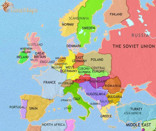
For comparison, here is a map of Europe circa the 1960s, which still isn’t the mid-80s, but for some reason this is the best map I could find that isn’t hyperfocused around one sub-region or the other and it’s generally more accurate to the mid-80s compared to a map from today:
So they had the general idea more or less right, it’s just that the Europa 2000 map is what happens when you don’t give animators enough time to fully reference stuff! (Or even enough time to trace an actual map outline.)
Anyway, Tumblr crashed on me twice while I was trying to make this post, so I’m leaving it here-- But shout out to those of you who live on or near the Europa 2000 race route! :) <3
#transformers#G1#maccadam#maccadams#fictional maps#fictional map#transformers g1#europa 2000#analysis post? lol#analysis post#long post
25 notes
·
View notes
Photo
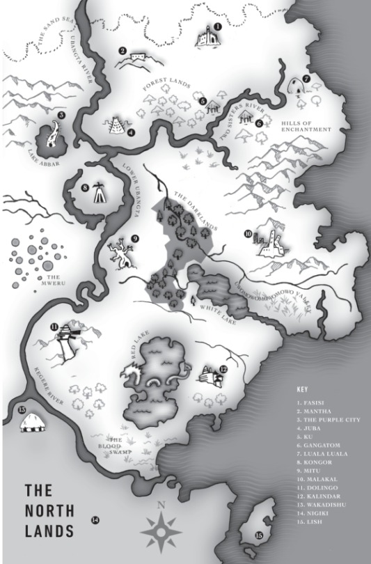


Maps of Marlon James’ Dark Star Trilogy
#black leopard red wolf#moon witch spider king#marlon james#dark star trilogy#books#novels#fantasy#fantasy books#maps#fiction#afrofuturism#afrofantasy#afrosurrealism#magic realism#adventure#literary fiction#black art#fictional maps#world building#poc in genre#african fiction#lgbtq fiction
61 notes
·
View notes
Text
Messed around with this map making website and mapped my sona's home continent of Russayn.

#starvix#lilacstarvix#proud of this#kinda pokemon universe edition because of the ruins and stuff#Old Russayn is actually elevated above the the rivers touching it and they actually flow underneath it#Russayn#fictional maps
10 notes
·
View notes
Text

A map of Western Alishara for the D&D setting of my campaign(s). If I was going to start over, I'd change most of the names, put more thought into the trade routes, and rework a good many of the rivers. But as an abstract it works well, I think.
5 notes
·
View notes
Photo

Hello There!
We’re a new blog set in the JP universe (but practically an AU at this point with what we’ve worked out) and we’re going to start off with a sort of series of introduction posts.
First things first, we’ve named our series of islands The Ivory Archipelago. The full name is Jurassic Park at The Ivory Archipelago, but we’re going to shorten it to JPTIA or just The Ivory Archipelago.
The map pictured above is a basic layout of the park; a white sand archipelago (hence the name) off the coast of Columbia that was previously undiscovered. The geography suggests that the islands are a few million years old and created through tectonic plate activity, but any volcanoes in the park are long extinct. Our park is complete, but we are looking at adding in a few expansions when the funding and animal genomes are more stabilized.
Our park places special emphasis on preserving the natural environment of both the island, and trying to integrate the newly resurrected dinosaurs into the present environment so they don’t imbalance the ecosystem. There is minimal (but still very strong) fencing and it utilizes the natural borders (mountains, rivers) already on the islands.
We hope this post caught your interest, and we’re looking forward to making more posts in the future! Be on the lookout for more general information, as it will be coming soon.
But before then, feel free to send us any asks and we’ll try to answer them as best we can!
General Island Layout
*Rules of the Islands for Guests*
About the Owners
#Jurassic park#Jurassic#Jurassic world#dinosaurs#The Ivory Archipelago#General information#introduction#introduction post#fictional maps#map#maps#fictional world#AU#Jurassic Park au
2 notes
·
View notes
Text
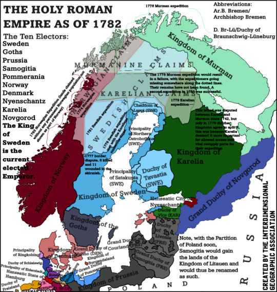
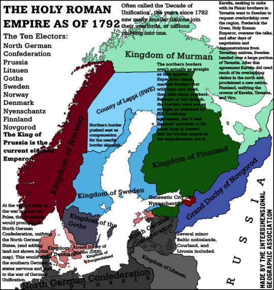
Two maps, both of the Holy Roman Empire as of 1782 and 1792 respectively.
#interdimensional#Interdimensionalgeographicassociation#Interdimensionalgeography#geography#Map#Maps#Fictional maps#alt history
6 notes
·
View notes
Text

I'm obsessed with Flat Earth conspiracy maps so I made my own, I hope it catches on 😇
1K notes
·
View notes
Text
Sirius could watch a sleeping Remus all night long. Forever even. Evading sleep himself in favour of indulging in something only he had the privilege of.
Tracing his fingertips along the scars on Remus’ face, turning silver from the light of the crescent moon that shone through the gap in the velvet draperies hanging around their bed. Watching as his brow furrowed and then relaxed from the touch of Sirius’ fingers. Listening to the rise and fall of his chest, and the quiet thumping of his heart through his shirt.
“Mmm,” he hears from Remus, eyes still closed. “What are you looking at?”
“You,” says Sirius, placing his chin on the other boy’s chest, watching him. “Just you.”
Remus cracks an eye open, “like what you see?”
“You are a treasure to behold, Remus John Lupin.”
#always thinking about them#wolfstar#alltoounwellll writes (sometimes)#sirius black#remus lupin#marauders#marauders era#sirius black x remus lupin#sleeping#wolfstar microfic#microfic#fiction#marauders map#remus john lupin#rj lupin
168 notes
·
View notes
Photo
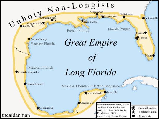
The Great Empire of Long Florida
2K notes
·
View notes
Text

I found an old map I drew in my high school stuff. Must have been bored in class one day lol
You know I’m gonna have to make it digitally now.
5 notes
·
View notes
Text
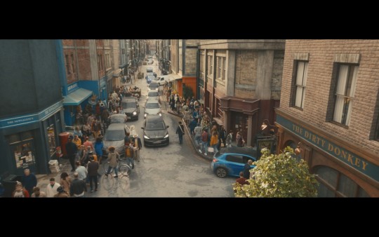
Map Of Whickber Street (Good Omens Soho around the bookshop)
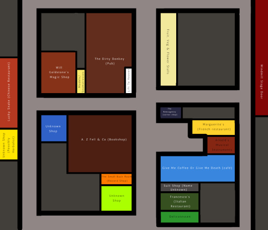
I had a lot of fun watching the entire series again and working out where all the shops were in relation to one another. Some of these are mentioned in canon, some are just shown. I've taken some liberties with scale and the like. It wasn't clear which of these streets is Whickber Street, but I suppose there must be some mystery left in the world.
I'm adding some photo references and some more information about the various shops below the cut. If you can make out any more names, I'd love to know.
It's possible the deli is also part of Francesco's as they're both Italian, but there is a front door by the awning that could lead to the restaurant (not an unusual set up for Soho). Francesco's awning is the victim of Crowley's rainstorm.
Between Francesco's and Give Me Coffee is a shop selling formal menswear that I couldn't make out the name of.
Next to that is the coffee shop, Arnold's (the musical instruments shop), Marguerite's (the French restaurant), and newsagency (the news agents). We get a lovely shot of them from the upstairs of the bookshop (newsagents just barely visible).

Opposite them, we obviously have the bookshop itself and down from that, the record shop (which is called The Small Back Room, presumably in reference to having started at the back of Aziraphale's bookshop). The record shop is the orange shop you can see below. (There's also a clearer view of the newsagents).
The shop one down from the record shop is currently a question mark, but it does have a very bold colour scheme, and at one point we are a candelabra and a piece of fabric in the window display. I can't make out the name of this one either.
Opposite the bookshop we have the pub, the Dirty Donkey, whose front door is also the lift to heaven when summoned. Next to the pub is the doorway that leads you to the brothel (I picked the colour on the map from the new model friendly hands sign on the door), and next to that is Will Goldstone's Magic Shop. The magic shop, bookshop and the pub can also be seen in 1941 London flashbacks. Opposite the magic shop and next to the bookshop is another unknown shop. My gut says it sells lighting or maybe more general electrics, but I couldn't get a good enough shot to really see it.

At the end of this street we can see the Lucky Snake which I believe is a Chinese Restaurant, and just to the left we can glimpse a yellow shop, that I suspect is the herbalist that we see mentioned on Aziraphale's list of local businesses. Soho and Chinatown are geographical neighbours, and it's not uncommon to see Chinese herbalist or health shops in Soho. The red lanterns from the Lucky Snake continue down over the yellow shop, which is what gave me the impression it might be the herbalist.
Directly across the crossroads from the bookshop we have a fruit and vegetable market, that has a flower stand on the corner. That's where the tomatoes roll from when Gabe is walking through naked. (The veggies are obscured in the shot below, but we do see them in general)

If we follow the road between the flower market and the newsagents, I've extrapolated that the stage entrance to The Windmill (the theatre that we see in 1941) is there. We get a moderately clear view of it during the flashback, and the Windmill is a real place (to my knowledge it's somewhere between a burlesque club and a strip club these days), so I figured it would still be standing here too. We get the briefest of glimpses of the stage door still standing in modern London.
If you care for real world geography, then The Windmill's main entrance is on Great Windmill Street, right off Shaftesbury Avenue, on the corner of Archer Street.
I could not for the life of me find Brown's World of Carpets anywhere. Maybe he's not even actually a local business. He seems the type to fake it.
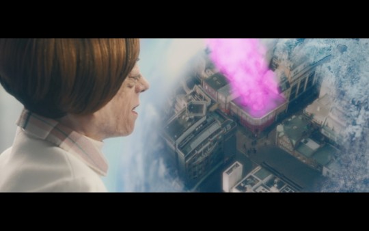
Here's a view of the area from heaven.
#good omens#good omens spoilers#good omens writing reference#writing reference#neil gaiman#fictional map#the goodest of omens
440 notes
·
View notes
Text
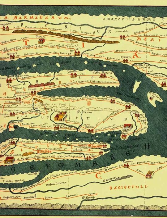
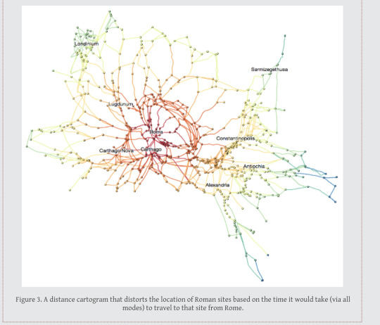
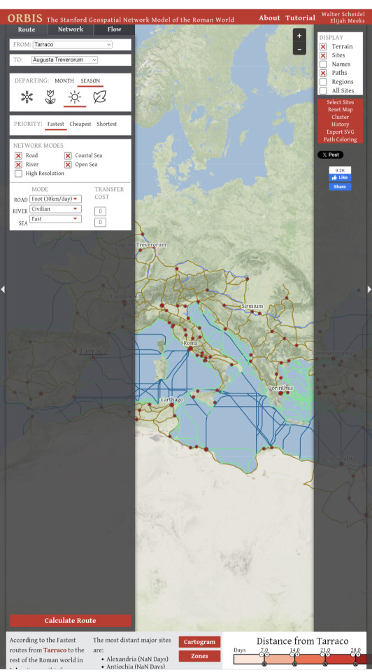
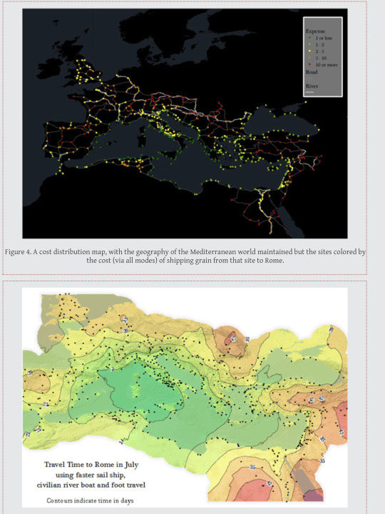
Geospatial model of the Roman World.
Want to know how long it would take to get from what is now Yorkshire to Rome in the first century? And the best route? And the expense?
If you are a historical novelist and you haven’t encountered this interactive site, you need to. It’s centered on the Roman Empire, but with care this info will translate to other eras.
#roman empire#ancient rome#interactive#maps#classical studies#medieval studies#travel#history#historical fiction
89 notes
·
View notes
Photo
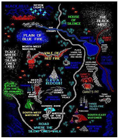
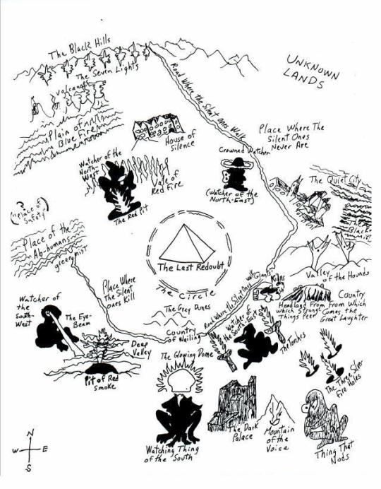
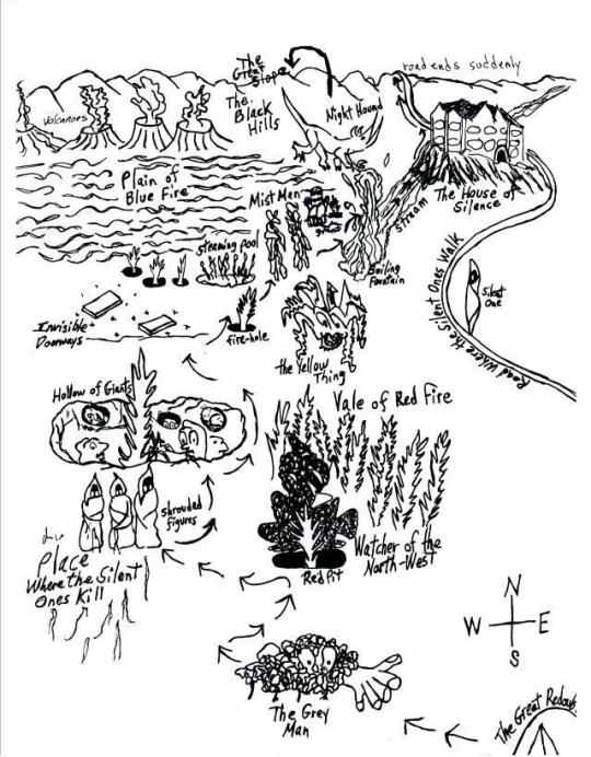
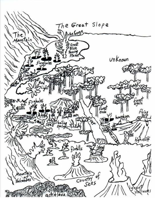
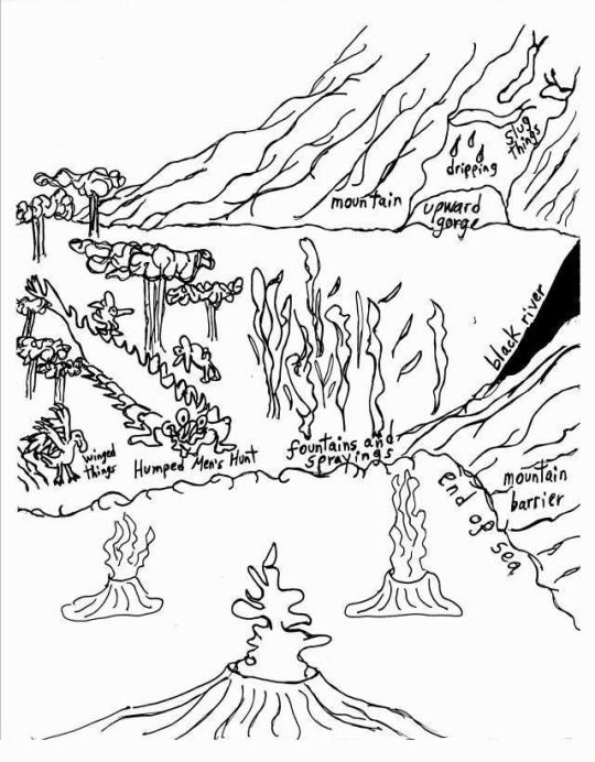
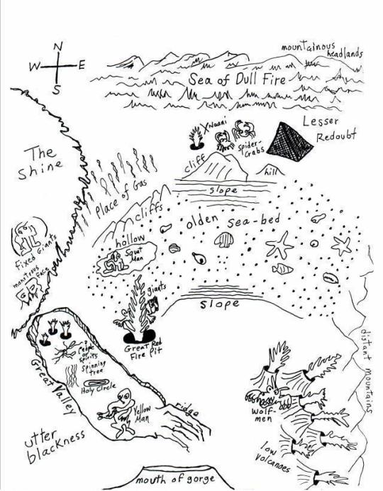
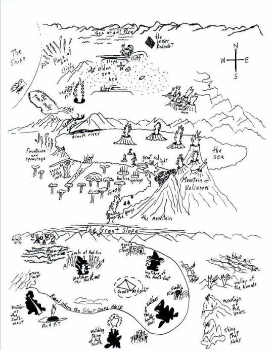
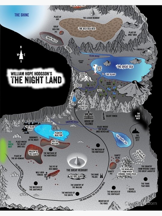
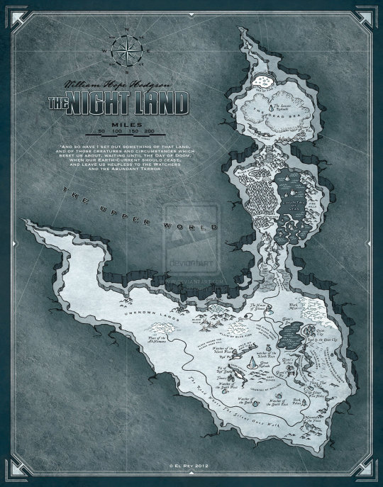
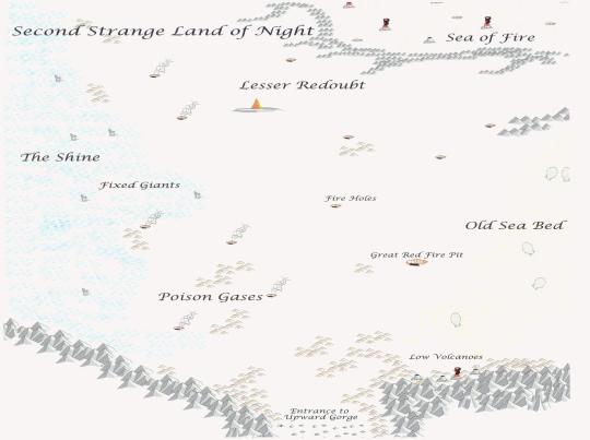
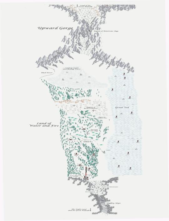
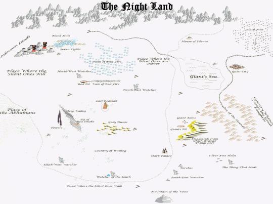
Maps of William Hope Hodgson’s The Nightland
#the nightland#william hope hodgson#wierd fiction#fiction#novels#books#maps#fictional maps#worldbuilding#mythos#dying earth#apocalpytic#fantasy maps#sci fi#horror#adventure#geography#1912
33 notes
·
View notes
Last Seen Blogs

ghost-of-a-wizard
Ghost of a Wizard

yuusishi
Ishi/Fremi

unhappyandunluckycampers-blog
technically not cc ocs but fuck the police
to-conquer-the-night
luxa is cooler than you

idconcern
I.D. Concern +++ João Dorminsky