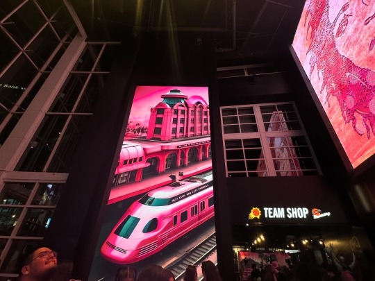
#footprint center
Text

Kevin Durant and Giannis Antetokounmpo
#Kevin Durant#Giannis Antetokounmpo#basketball#sports#nba#milwaukee bucks#phoenix suns#fiserv forum#footprint center#illustration#illustrators#illustrators on tumblr#art#artists#artists on tumblr
28 notes
·
View notes
Quote
Dancers from Indigenous Enterprise performed at Monday's Opening Night festivities, becoming the first Native Americans to perform at the annual media mega event. In a strange juxtaposition, they took the stage minutes after Kansas City fans in attendance at the Footprint Center joined together in a loud rendition of their "tomahawk chop" chant. "What the NFL is doing inside Phoenix, by bringing in indigenous dancers and artists, that's celebrating the authentic, which is wonderful," said Cher Thomas, an artist, community organizer and member of the Gila River Community. She will be among those outside the game protesting. "However, the NFL simultaneously condones Kansas City's team and their names and monikers and their derogatory traditions."
‘Native Americans call for Super Bowl team to change name’, RNZ
#RNZ#Native Americans#United States#Super Bowl#NFL#Indigenous Enterprise#Kansas City Chiefs#Footprint Center#tomahawk chop#Phoenix#Cher Thomas#Gila River Community
6 notes
·
View notes
Text

[240413] Footprint Center's official twitter update:
ateezlive.com
Credit: FootprintCNTR
1 note
·
View note
Text

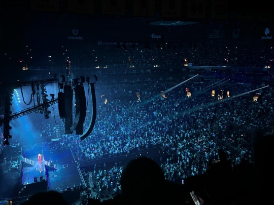
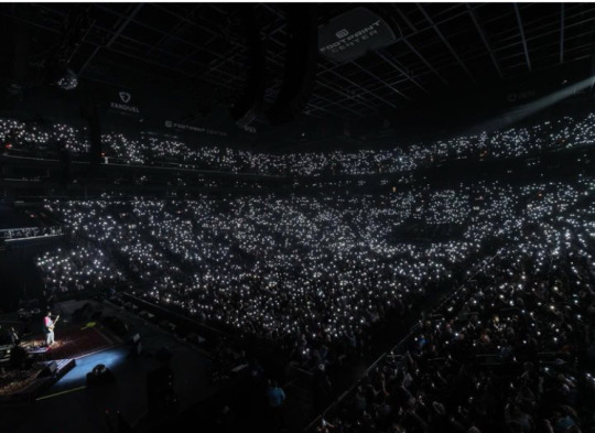
a throwback a few weeks ago to when i landed in gag city 📍
#nicki minaj#queen nicki#gag city#arizona#az#me#cute#phoenix#mine#phx#travel#selfie#about me#concert#footprint center#rap
1 note
·
View note
Text
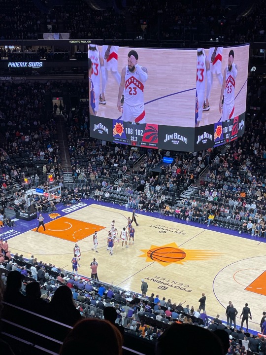
Nothing like a W in the Valley!
1 note
·
View note
Text
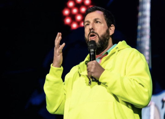


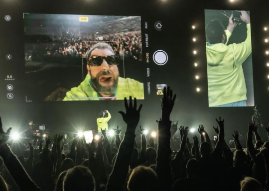
Last show of the tour. Couldn't have been more fun. Man that was a rockin' night. Love u all and won't forget it. Look forward to going out again soon. #footprintcenter #adamsandler #adamsandlerstandup #therealadamsandler
1 note
·
View note
Text
they need to have popular artists & bands play at small niche venues simply for my pleasure and preference. look me in my eyes and tell me going to a concert at a giant sports arena is better than the intimacy of small seedy bars and basements.
5 notes
·
View notes
Text
HEY that's not mechanical
#people shit on that model a lot cause its membrane but it has the best tenting you can find#not to mention the smallest footprint#typically to get this angle a keyboard needs legs in the center which makes breaks up usable desk space and sucks#or the case is solid and theres no open space under the keyboard at all...
27 notes
·
View notes
Text
I really don't know what to fucking do if it doesn't come today
Like the pharmacy would be like uhhhh we sent it LAST WEEK and the post office will be either like "someone stole it sorry not our problem," or "you'll fucking get it when you get it bitch, plan better"
Like sorry I planned to call it Monday to get it by Thursday/Friday, forgot it was a fucking holiday, and that the snow storm was worse than expected! Give me my meds!
#marquilla#i really dont know what the fuck i can do to help myself in the meantime and im getting worried someone DID steal it#like not off my porch bc i get the mail like seconds after she drops it and i only saw her footprints in the snow#but like that someone stole it from the center or truck bc we've been having inside job mail thefts... but thats more so stealing checks#from bday cards... still im just feeling so hopeless and idk what to do#i wish i could sleep ive been awake since 1:30 bc the pain woke me up#it hurts to breathe man my spine hurts and i wanna die
4 notes
·
View notes
Text

Kevin Durant
#Kevin Durant#basketball#sports#nba#phoenix suns#footprint center#illustration#illustrators#illustrators on tumblr#art#artists#artists on tumblr
23 notes
·
View notes
Text
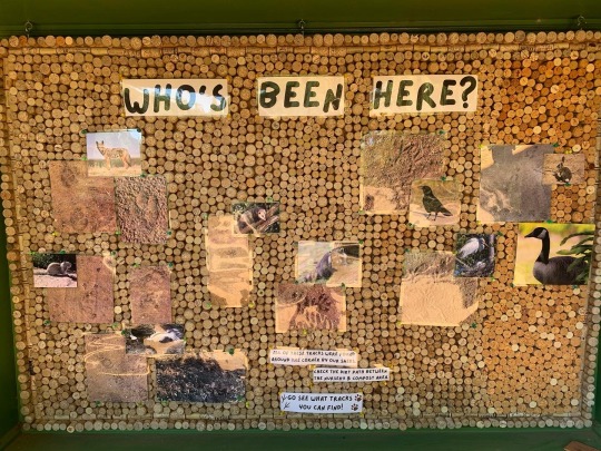
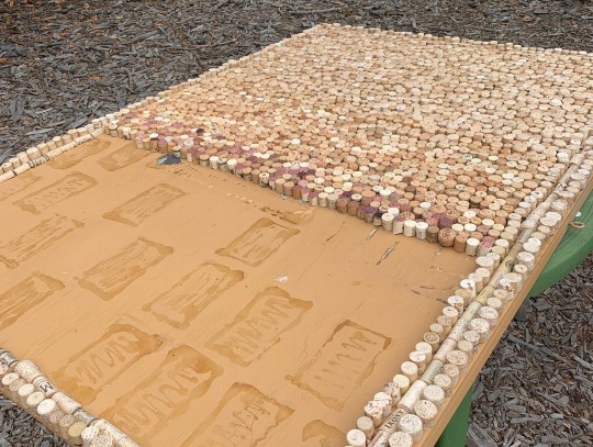
My newest project for The Shipley Nature Center is done! It has been under construction for a couple of months do to making our own up-cycled cork board. The corks were donated by guests and the footprints by various residents of the nature preserve.
1 note
·
View note
Text
MIT researchers map the energy transition’s effects on jobs
New Post has been published on https://thedigitalinsider.com/mit-researchers-map-the-energy-transitions-effects-on-jobs/
MIT researchers map the energy transition’s effects on jobs
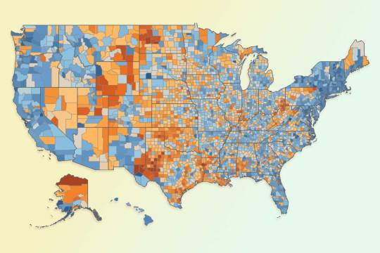
A new analysis by MIT researchers shows the places in the U.S. where jobs are most linked to fossil fuels. The research could help policymakers better identify and support areas affected over time by a switch to renewable energy.
While many of the places most potentially affected have intensive drilling and mining operations, the study also measures how areas reliant on other industries, such as heavy manufacturing, could experience changes. The research examines the entire U.S. on a county-by-county level.
“Our result is that you see a higher carbon footprint for jobs in places that drill for oil, mine for coal, and drill for natural gas, which is evident in our maps,” says Christopher Knittel, an economist at the MIT Sloan School of Management and co-author of a new paper detailing the findings. “But you also see high carbon footprints in areas where we do a lot of manufacturing, which is more likely to be missed by policymakers when examining how the transition to a zero-carbon economy will affect jobs.”
So, while certain U.S. areas known for fossil-fuel production would certainly be affected — including west Texas, the Powder River Basin of Montana and Wyoming, parts of Appalachia, and more — a variety of industrial areas in the Great Plains and Midwest could see employment evolve as well.
The paper, “Assessing the distribution of employment vulnerability to the energy transition using employment carbon footprints,” is published this week in Proceedings of the National Academy of Sciences. The authors are Kailin Graham, a master’s student in MIT’s Technology and Policy Program and graduate research assistant at MIT’s Center for Energy and Environmental Policy Research; and Knittel, who is the George P. Shultz Professor at MIT Sloan.
“Our results are unique in that we cover close to the entire U.S. economy and consider the impacts on places that produce fossil fuels but also on places that consume a lot of coal, oil, or natural gas for energy,” says Graham. “This approach gives us a much more complete picture of where communities might be affected and how support should be targeted.”
Adjusting the targets
The current study stems from prior research Knittel has conducted, measuring carbon footprints at the household level across the U.S. The new project takes a conceptually related approach, but for jobs in a given county. To conduct the study, the researchers used several data sources measuring energy consumption by businesses, as well as detailed employment data from the U.S. Census Bureau.
The study takes advantage of changes in energy supply and demand over time to estimate how strongly a full range of jobs, not just those in energy production, are linked to use of fossil fuels. The sectors accounted for in the study comprise 86 percent of U.S. employment, and 94 percent of U.S. emissions apart from the transportation sector.
The Inflation Reduction Act, passed by Congress and signed into law by President Joe Biden in August 2022, is the first federal legislation seeking to provide an economic buffer for places affected by the transition away from fossil fuels. The act provides expanded tax credits for economic projects located in “energy community” areas — defined largely as places with high fossil-fuel industry employment or tax revenue and with high unemployment. Areas with recently closed or downsized coal mines or power plants also qualify.
Graham and Knittel measured the “employment carbon footprint” (ECF) of each county in the U.S., producing new results. Out of more than 3,000 counties in the U.S., the researchers found that 124 are at the 90th percentile or above in ECF terms, while not qualifying for Inflation Reduction Act assistance. Another 79 counties are eligible for Inflation Reduction Act assistance, while being in the bottom 20 percent nationally in ECF terms.
Those may not seem like colossal differences, but the findings identify real communities potentially being left out of federal policy, and highlight the need for new targeting of such programs. The research by Graham and Knittel offers a precise way to assess the industrial composition of U.S. counties, potentially helping to target economic assistance programs.
“The impact on jobs of the energy transition is not just going to be where oil and natural gas are drilled, it’s going to be all the way up and down the value chain of things we make in the U.S.,” Knittel says. “That’s a more extensive, but still focused, problem.”
Graham adds: “It’s important that policymakers understand these economy-wide employment impacts. Our aim in providing these data is to help policymakers incorporate these considerations into future policies like the Inflation Reduction Act.”
Adapting policy
Graham and Knittel are still evaluating what the best policy measures might be to help places in the U.S. adapt to a move away from fossil fuels.
“What we haven’t necessarily closed the loop on is the right way to build a policy that takes account of these factors,” Knittel says. “The Inflation Reduction Act is the first policy to think about a [fair] energy transition because it has these subsidies for energy-dependent counties.” But given enough political backing, there may be room for additional policy measures in this area.
One thing clearly showing through in the study’s data is that many U.S. counties are in a variety of situations, so there may be no one-size-fits-all approach to encouraging economic growth while making a switch to clean energy. What suits west Texas or Wyoming best may not work for more manufacturing-based local economies. And even among primary energy-production areas, there may be distinctions, among those drilling for oil or natural gas and those producing coal, based on the particular economics of those fuels. The study includes in-depth data about each county, characterizing its industrial portfolio, which may help tailor approaches to a range of economic situations.
“The next step is using this data more specifically to design policies to protect these communities,” Knittel says.
#000#2022#Analysis#approach#biden#carbon#carbon footprint#Center for Energy and Environmental Policy Research#clean energy#climate change#coal#Community#Composition#data#Design#economic#Economics#economy#effects#Emissions#employment#energy#energy consumption#energy production#Environmental#fossil#Fossil fuels#fuel#fuels#Full
0 notes
Text
This New Park Gives Different Views of the Grand Canyon—with No Crowds
These sacred Indigenous lands in Arizona just got government protection. Here’s how to explore their hikes, wildlife, and impressive vistas.
— By Joe Yogerst | September 1, 2023

Red Butte, which the Havasupai people call Wii'i Gdwiisa (“Clenched Fist Mountain”), is one of many sacred Indigenous sites within Arizona’s new Baaj Nwaavjo I’tah Kukveni Grand Canyon National Monument. Named a national monument by President Joseph Biden in August 2023, the one-million-acre wilderness offers hiking, backcountry camping, and views of the Grand Canyon without the crowds. Photograph By Taylor McKinnon, Center For Biological Diversity
Grand Canyon National Park draws 4.7 million visitors a year to the northwest corner of Arizona to hike, camp, or watch wildlife. But most of them don’t realize that the lands within and surrounding the park are sacred to the region’s 12 Indigenous tribes, which include the Havasupai, Hopi, Navajo, and several bands of Paiute.
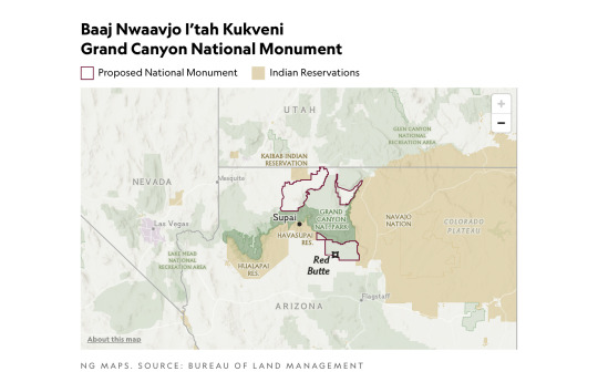
That changed on August 8 when President Joseph Biden signed a decree creating the Baaj Nwaavjo I’tah Kukveni—Ancestral Footprints of the Grand Canyon National Monument. Sprawling across more than 960,000 acres directly north and south of the national park, the new monument offers more rugged, less crowded recreation than its neighbor. It also provides a view of the landscape through Indigenous eyes.
“Baaj nwaavjo in Havasupai means ‘where the ancient people roamed,’” says Carletta Tilousi, coordinator of the Grand Canyon Tribal Coalition. “I’tah kukveni is the Hopi translation of ‘ancestral footsteps’. This reaffirms their creation stories.”
Here’s how the monument came to be, and how to explore it.
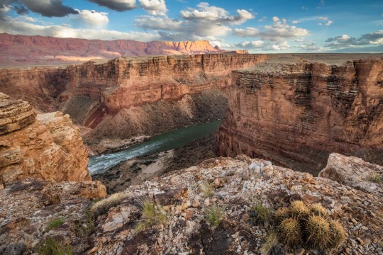
Baaj Nwaavjo I’tah Kukveni yields views of the Colorado River and Grand Canyon from a different perspective. Photograph By Amy S. Martin
How to Make a National Monument
It took two million years for the Grand Canyon itself to form and around 40 years for Baaj Nwaavjo I’tah Kukveni to become reality. “The protection for these lands is something the tribes have focused on since as far back as the 1980s,” says Amber Reimondo of the Grand Canyon Trust, a nonprofit devoted to preserving the region.
Many of these Indigenous people were expelled from their territory when Grand Canyon National Park was established in 1919. They campaigned for decades to receive stronger protection for their lands around the park, overcoming entities that wanted fewer legal obstacles to development and mining. After President Biden’s election in 2020, the 12 tribes formed a coalition which led to the lands receiving federal status.
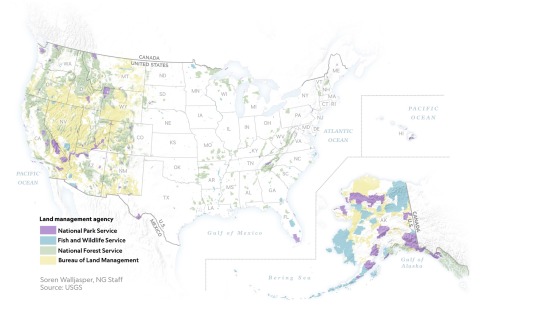
Though the National Park Service oversees Grand Canyon National Park, monuments such as Baaj Nwaavjo I’tah Kukveni are run by the U.S. Forest Service (USFS) and the Bureau of Land Management (BLM). Monuments generally have fewer restrictions regarding their use (e.g., sometimes hunting or logging is allowed), as well as fewer facilities for visitors.
Fewer Amenities, Fewer Crowds
Like many national monuments, Baaj Nwaavjo I’tah Kukveni exudes raw nature. It has no bathrooms or visitor center; access is primarily via dirt roads or rough trails; you’ll need a four-wheel-drive to reach many sections of the park.
What it offers is solitude and peace amid the forests and grasslands of northern Arizona. You can gaze at the Grand Canyon without thousands of other people jostling for the same space, hike trails where yours are the only footsteps, and make camp at secluded spots. Plus you might encounter wildlife such as elk, black bear, mule deer, birds, or bison.
That solitude is also important to the Indigenous people. Tilousi says that when she visits the busy South Rim inside Grand Canyon National Park, “It’s very difficult for me to find a spot where I can offer prayers and offerings in a quiet way.” She feels that won’t be an issue in the off-the-beaten-track lands of the new monument.

Native plants including yucca flourish within Baaj Nwaavjo I'teh Kukveni National Monument. Photograph By Amy S. Martin
Exploring the Monument
The vast wilderness of Baaj Nwaavjo I’tah Kukveni is divided into three distinct sections or parcels, each with its own appeal.
The southernmost section, the Tusayan Ranger District/South Parcel, is the easiest to explore. Comprising 330,000 acres within the Kaibab National Forest, its pine woodlands and sagebrush prairie are accessible via Forest Service roads or Sections 35 through 37 of the Arizona Trail, an 800-mile hiking route stretching across the entire state.
The South Parcel also shows signs of human life, including the rusty hangar of the 1920s Red Butte Airfield and the 80-foot-tall Grandview Lookout Tower, which you can climb for views of the Colorado Plateau and the Grand Canyon.
The other sections of the monument, Kanab Plateau/Northwest Parcel and Rock House Valley/Northeast Parcel, are located beyond the North Rim section of Grand Canyon National Park.
“It's a big, remote wilderness,” says Michael Cravens, advocacy and conservation director of the Arizona Wildlife Federation. “I’ve never in my life been somewhere with night skies that spectacular.” But he cautions visitors “to be careful and prepared” for the extreme weather and topography. You can reach the northern parcels on BLM roads south of U.S. Highway 89A.

The vast House Rock Valley stretches through a portion of the new national monument. Photograph By Taylor McKinnon, Center For Biological Diversity
Stretched across the Kanab Plateau and Antelope Valley, the Kanab Plateau section has hiking routes through spectacular side canyons and to panoramic views such as Gunsight Point.
The Hack Trail drops down into the Kanab Creek Wilderness with its enormous red-rock canyons, a landscape almost as impressive as the Grand Canyon itself. Experienced hikers can continue down Kanab Creek to the Colorado River or along other trails to vertiginous overlooks along the North Rim.
Set beneath the Vermilion Cliffs National Monument, the Rock House Valley section of Baaj Nwaavjo I’tah Kukveni tumbles across sagebrush flats to the edge of Marble Canyon. Rugged hiking trails here include the Soap Creek Trail, which winds down from the Rapids/Badger Camp Overlook to a primitive campsite near the river.
Rough roads lead south to viewpoints for Rider Canyon, South Canyon, and other offshoots of the Grand Canyon. Here, you might even spot the North Rim’s resident bison herd, brought to the Arizona Strip in 1906 by Charles “Buffalo” Jones as part of efforts to save the species.
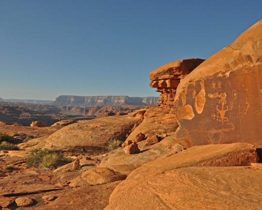
Ancient rock art can be spotted in the Kanab Creek Wilderness portion of Baaj Nwaavjo I’tah Kukveni National Monument. Photograph By Natpar Collection, Alamy Stock Photo

The Havasupai Indian Reservation in Arizona, which includes the Havasu Waterfall—part of the Havasupai Falls—is the current home of the Havasupai people. After the Grand Canyon became a national park, they were forcibly removed from their traditional homelands in the canyon and in nearby lands that will be part of the new national monument. Photograph By Mike Theiss National Geographic Image Collection
1 Million Acres of ‘Sacred’ Land Near Grand Canyon are Receiving New Protections! The designation of the land as a national monument, confirmed to National Geographic this week by the White House, will prevent new uranium mines and protect historically significant tribal lands.
#United States 🇺🇸 National Parks#New Park#Grand Canyan#Indigenous Lands#Arizona#Wildlife#Red Butte | Clenched Fist Mountain#Arizona | Baaj Nwaavjo I’tah Kukveni Grand Canyon National Monument#Center For Biological Diversity#President Joe Biden#Carletta Tilousi | Coordinator | Grand Canyon Tribal Coalition#Ancestral Footprints#Colorado River#Amber Reimondo | Grand Canyon Trust | Non-profit | Region Preservation#National Park Service#U.S. Forest Service (USFS) | The Bureau of Land Management (BLM).#Wildlife | Elk | Black Bear 🐻 | Mule | Deer 🦌 | Birds 🦅 | Bison 🦬#Hike Trails#Off-The-Beaten-Track Lands#Tusayan Ranger District | South Parcel#Kaibab National Forest 🌳#Colorado Plateau#Kanab Plateau/Northwest Parcel | Rock House Valley/Northeast Parcel#U.S. Highway 89A#Michael Cravens | Arizona Wildlife Federation#Kanab Plateau | Antelope Valley#Gunsight Point#Hack Trail#Vermilion Cliffs National Monument#Rock House Valley
1 note
·
View note
Text
This is what Devin Booker’s Statue in front of Footprint Center is going to look like! #devinbooker #statue #footprintcenter #suns #phoenixsuns #nba #nba24highlights #nbahighlights #sunsvsclippers #nbaplayoffs #nbaplayoffs2023 #fypfypfypfypfypfypfypfypfypfypfyp #fypfypfypfyp #fypfypfyp #viralfyp #fypfyp #viralfyp #viraltiktok #fyptiktok #viral #fyp
#CapCut
#This is what Devin Booker’s Statue in front of Footprint Center is going to look like!#devinbooker#statue#footprintcenter#suns#phoenixsuns#nba#nba24highlights#nbahighlights#sunsvsclippers#nbaplayoffs#nbaplayoffs2023#fypfypfypfypfypfypfypfypfypfypfyp#fypfypfypfyp#fypfypfyp#viralfyp#fypfyp#viraltiktok#fyptiktok#viral#fyp#CapCut
0 notes
Text
GPT-3's training alone required 185,000 gallons (700,000 liters) of water. According to the study, a typical user's interaction with ChatGPT is equivalent to emptying a sizable bottle of fresh water onto the ground.
Researchers worry that all this consumption could hurt water supplies given the chatbot's enormous popularity, especially in light of the past droughts and impending environmental instability in the US.
Microsoft, which has partnered with OpenAI for multiple years and billions of dollars and built supercomputers for AI training, claims that its most recent supercomputer, which would require an extensive cooling apparatus, contains 10,000 graphics cards and over 285,000 processor cores, providing a glimpse into the enormous scale of the operation behind artificial intelligence.
In other words, ChatGPT, which followed GPT-3, would need to "drink" a 500-milliliter water bottle to finish a fundamental discussion with a user of around 25–50 questions.
The enormous volume of water required to train the AI model also presupposes that the training occurs at Microsoft's cutting-edge US data center, which might cost tens of millions of dollars to build just for OpenAI.
According to the research, water use might have increased threefold if the data had been generated in the business' less energy-efficient Asian data center. With more recent models, like the just-released GPT-4, which depend on a broader range of data factors than their predecessors, the researchers anticipate that these water requirements will continue to rise.
“AI models’ water footprint can no longer stay under the radar,” the researchers said. “Water footprint must be addressed as a priority as part of the collective efforts to combat global water challenges,” they added.
#chatgpt#water consumption#GPT-3 training consumed 700k liters of water#'enough for producing 370 BMWs'#ai#green footprints#electronic data center water usage stats
0 notes
Text
Decarbonizing Data Centers for a Data-driven Sustainable Society

The need for data center sustainability
Digital services like streaming, emails, online shopping, and more – can reach an infinite number of people without occupying physical space. However, there is an urgent need to decarbonize data storage, management, access and distribution and data center electricity itself is likely to increase to 8 percent of the projected total global electricity demand by 2030, 15-fold of what it is today.^ Energy-efficient data centers are therefore a key climate priority.
Hitachi helps reduce the data center carbon footprint
Hitachi is focused on a sustainable future and contributing to society through the development of superior, original technology and products. Hence, it aims to reduce the environmental impact of data centers through technology and data-driven approaches.
According to research by Stanford Energy, with the right innovative solutions, data center carbon emissions could decrease by 88 percent%^^. Understanding the carbon footprint of a data center is not enough. Leveraging tools to help collaborate across infrastructure, building, energy, and corporate management to gain visibility on consumption and emissions can make a difference.
Data centers are also increasing their use of renewable power sources. But many of these are purchasing carbon credits instead of generating energy on-site or nearby. Data centers also need to reduce their energy consumption. They can use carbon footprint analytics to optimize their equipment. This involves analyzing how much space the equipment requires, how much heat is being generated, and how that can be controlled more efficiently. Meanwhile, software developers can create sustainable applications to minimize their environmental impact as well.
If done right, all these measures can enhance the environmental performance of both existing data centers and future facilities.

Working together to incorporate data center sustainability
Data center sustainability and energy optimization strategies involve multifaceted approaches that include:
Investing in conversations and analyzing an organization’s current position and where it needs progress.
Creating a pilot project and replicating it later, if successful.
Defining milestones to build momentum for the overall sustainability journey.
At Hitachi, we develop green data center solutions that span technological, organizational, training and regulatory challenges to help organizations for future green data center certifications and emerging audit standards.
Hitachi has set a goal of carbon neutrality at its business sites by 2030 and across the entire value chain by 2050. The data center emissions challenge is an opportunity to lead by example through green and digital innovation and contribute towards a sustainable society
The dawn of a new sustainable beginning has just begun.…
Discover how Hitachi is unlocking value for society with Social Innovation in Energy:
Sources :
^ https://corporate.enelx.com/en/stories/2021/12/data-center-industry-sustainability
^^ https://energy.stanford.edu/news/data-centers-can-slash-co2-emissions-88-or-more
#green data center#sustainable data center#energy efficient data centers#green data center solutions#data center energy efficiency#data center power consumption#data center impact on environment#data center carbon footprint#data center carbon emissions#data center optimization#decarbonization#sustainability
0 notes
Last Seen Blogs

hzrosex-blog
Hz Rose

mimithaimassage
Mimi Thai massage

greveenciaa
May Bee😈

askresetsans-blog
Ask Reset!Sans

fuckavirus
Get Me OUT of 2020