#geoinformatics
Text
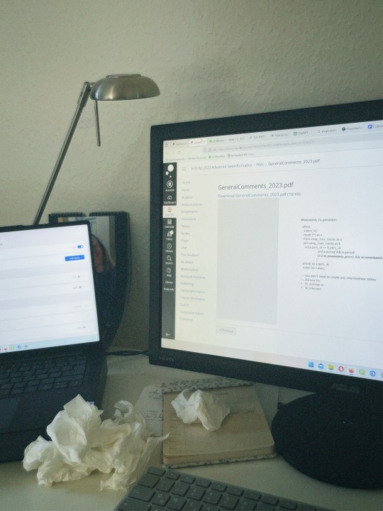

Whyyyy do I have to keep getting sick at the most inconvenient times?? 🤧🤧
#studyblr#geography#study#desk#motivation#uni#mine#study setup#studying#study aesthetic#exam#college cough ?#geoinformatics#student struggle
41 notes
·
View notes
Text
Why I care about history so much

Okay, because I have been asked about this a lot: No, I am not a historian. And I am not studying religion or mythology either. In fact I did my first masters degree in economics and currently am working on my second degree in geoinformatics. So... why do I write so much about history?
So, the easy answer is: I am autistic. I hyperfocus on history.
But there is also a more complicated answer to this.
See, what I want to do with my life is actually to work in science communication and especially work towards this with climate change and ecology. That is also why I do geoinformatics, because part of that is actually using maps and software to communicate this kind of information.
And here is the thing where history comes in. See, we often act as if the social science and the STEM fields are super far apart and super different. But I am going to tell you: They are not. Because it is all connected.
Climate change is the best example. There is a "history of climate change" as in a history of how we found out it was happening and how the fossil fuel tried to bury it. Climate change is also a topic where social science do intersect a lot of STEM stuff. How people behave in groups, how people interact with information, an how to communicate information is important for this.
A funny thing happened yesterday. I have one class this semester called "Geoinformatics in Society", which is kinda about this: How to use geoinformatics to communicate information to people. Yesterday the professor showed us some examples of this. One of them was a graphic showing a very abstract version of change over time of the life expectancy of countries between 1800 and 2015. And the prof was asking us about storytelling in it and what we could see. And me, who again has a hyperfocus on history, looked at it: "Oh, yeah, here we see the polio vaccine being given out. Oh, and there is the Spanish flu happening. These are the world wars. Oh, there was a famine hitting China." And so on. Because... well, those things intersect. The reason why life expectancy rose is largely to be attributed to science - but also to societal factors. These things intersect.
The professor in question is doing research on this kinda stuff. Which is something that people in my area do research on. So, yeah, it intersects.
But there is another reason, too. I am trans, queer and disabled. As such I experience a lot of marginalization and discrimination. And... well, understanding that is also just a need for me. And you need to understand history to understand that.
And when it comes to this... Well, you cannot just look at one thing in history and say "Oh, yeah, this is why this is happening." Because, well, so many factors play into it. Like, sure, there is Nazism playing into it. And eugenics. But you cannot look at either without looking at both the Enlightenment movement and colonialism. And well, you cannot look at those without looking at the crusades and the spice trade. And those? Well, you cannot talk about those without Byzantium. And for those you need to understand Rome and then... well, you get what I am getting at, right?
Everything is intersecting. And I think... I think understanding that is important.
#personal#history#autism#neurodivergent#hyperfixation#stem#science#science communication#sociology#geoinformatics
53 notes
·
View notes
Text
youtube
#youtube#cartography#forestry#geoinformatics#gps#image processing#hydrology#gis#earth science#mapping
2 notes
·
View notes
Text

screenshots from a mapping seminar i took this fall
0 notes
Text
GIS Services in Canada
GIS services are crucial for RS Solar CAD Group's operations, aiding in site selection, solar panel placement, and infrastructure planning. Our offerings include spatial analysis, data visualization, and custom mapping solutions tailored to meet the unique needs of solar energy projects. With our expertise, RS Solar CAD Group can optimize their designs, minimize environmental impact, and maximize energy production efficiency.
Our Services include Solar Design Services | GIS | CAD/Drafting | BIM | Project management | Civil Engineering | MEP | Permit plan set
To know more contact us Email: [email protected]/ [email protected] or calling / Whatsapp at +919958060424
#gis#geospatial#mapping#geography#cartography#geodata#spatialanalysis#geoinformatics#geospatialintelligence#geospatialtechnology#permit#proposals#engineeringstamp#solar#solarenergy#solarpower#solarinstallation#usa#usajobs#california#washington#oregon#nevada#idaho#montana#arizona#utah#colorado#newmexico#texas
0 notes
Text
Geoinformatics Colleges in India: A Comprehensive Guide
Are you passionate about geospatial technology and its applications? Do you want to pursue a career in geoinformatics? If so, you've come to the right place! In this article, we will explore the top geoinformatics colleges in India and provide you with all the information you need to make an informed decision about your future.

What is Geoinformatics?
Before we dive into the details of geoinformatics colleges in India, let's first understand what geoinformatics is all about. Geoinformatics is an interdisciplinary field that combines geography, geology, computer science, and information technology to analyse and interpret spatial data. It involves the use of various tools and techniques to collect, store, process, analyse, and visualise geographic information.
Courses offered for Geoinformatics
If you're interested in pursuing a career in geoinformatics, it's important to know what courses are available and what they entail. Here are some geoinformatics course details offered by geoinformatics colleges in India:
1. Bachelor's Degree in Geoinformatics
A bachelor's degree in geoinformatics is the first step towards building a successful career in this field. This course typically spans over three to four years and covers a wide range of topics such as GIS (Geographic Information System), remote sensing, spatial analysis, database management, and cartography. Some colleges also offer specialised courses in areas like environmental management and urban planning.
2. Master's Degree in Geoinformatics
If you want to further enhance your knowledge and skills in geoinformatics, you can pursue a master's degree in this field. A master's degree program usually lasts for two years and provides advanced training in areas such as geospatial data analysis, geodatabase design, web mapping, and geospatial programming. Many colleges also offer research opportunities for students who wish to delve deeper into specific topics.
3. Diploma/Certificate Courses
Apart from bachelor's and master's degree programs, there are also several diploma and certificate courses available for those who want to gain specialised knowledge in specific areas of geoinformatics. These short-term courses focus on topics such as remote sensing applications, GIS software, and spatial data analysis.
Top Geoinformatics Colleges in India
Now that we have a basic understanding of geoinformatics and its course details, let's take a look at some of the top geoinformatics colleges in India:
Indian Institute of Remote Sensing (IIRS)
Indian Institute of Remote Sensing (IIRS), located in Dehradun, Uttarakhand, is another renowned institute that offers excellent programs in remote sensing and geoinformatics. The institute is affiliated with the Indian Space Research Organization (ISRO) and provides world-class training and research opportunities to students.
National Institute of Technology (NIT) Warangal
National Institute of Technology (NIT) Warangal offers a comprehensive program in geoinformatics at both undergraduate and postgraduate levels. The institute has state-of-the-art facilities, well-equipped laboratories, and experienced faculty members who are actively involved in research projects.
Symbiosis Institute of Geoinformatics (SIG)
Located in Pune, Maharashtra, SIG is one of the premier institutes for geoinformatics education in India. It offers a variety of undergraduate, postgraduate, and diploma programs in geoinformatics. The institute has a state-of-the-art infrastructure, experienced faculty members, and strong industry connections, making it an ideal choice for aspiring geospatial professionals.
Scope of Geoinformatics
After completing your education in geoinformatics, you'll have a wide range of career opportunities to explore. Here are some possible MSc geoinformatics scopes:
1. GIS Analyst: As a GIS analyst, you'll be responsible for collecting, analyzing, and interpreting geographic data using GIS software.
2. Remote Sensing Specialist: Remote sensing specialists use satellite imagery and other remote sensing techniques to gather information about the Earth's surface.
3. Spatial Data Scientist: Spatial data scientists analyze spatial data using statistical techniques to derive meaningful insights.
4. Urban Planner: Urban planners use geospatial technology to develop plans for land use, transportation systems, and urban development.
5. Environmental Consultant: Environmental consultants assess the impact of human activities on the environment using geospatial tools.
These are just a few examples of the career paths you can pursue with an MSc degree in geoinformatics. The demand for skilled professionals in this field is growing rapidly, both in India and abroad.
Conclusion
Geoinformatics is a fascinating field that offers exciting career opportunities for those who are passionate about spatial data analysis and interpretation. By pursuing a degree in geoinformatics from one of the top colleges mentioned above, you’ll gain the necessary knowledge and skills to excel in this field. We recommend SIG from Pune as it offers the perfect blend of education and experience you need for your career ahead.
Remember to thoroughly research each college’s curriculum, faculty expertise, infrastructure, and industry connections before making a decision. Good luck with your academic journey!
1 note
·
View note
Text
today was such a good day i love life
#my coworkers talked to me even the one who's usually quiet because they're nervous about speaking german#it was so nice we got talking about geoinformatics and she really lit up like you can tell she much prefers that to field work#she resigned a month into the job but like good for her because it's rlly not what she wants to be doing and you can rlly see that#but because of it i'm used to her being a bit listless and sullen but talking to her today her eyes were shining and she was so lively#it just made me believe more that the wrong type of work can make people so so miserable#everyone should be in the position to do something they can enjoy#anyway and then i hung out with the feminism group and they're all such darlings!! and i <33#and i talked to my dad on the phone and yeah <33#and the sun was out#a day full of love :)#emma talks
3 notes
·
View notes
Text
why is the last day at work before holidays always the absolute worst day at work??????
1 note
·
View note
Text
The Geoinformatics Course in Punjab offered by Amity University is designed to equip students with the knowledge and skills to leverage geospatial technologies and data analytics in solving real-world problems. With a focus on practical applications, the program trains students to use cutting-edge tools and techniques for data acquisition, analysis, and visualization
0 notes
Text


I’ve been here for 3 months now. I found friends, I am moving to a (hopefully) better place tomorrow and I am slowly starting to acclimate myself with Copenhagen!
I also applied for an exchange semester at Exeter university next fall and I got accepted.
Should I do it?? It’d mean that I do one out of 4 terms in Exeter and start writing my thesis afterwards. I’d move again. And again. I’d meet new people again. What do I do? 😂😭
Any advice? 🥺
#studyblr#geography#study#desk#motivation#uni#mine#study setup#studying#study aesthetic#Uni Exeter#Uni Copenhagen#geoinformatics#exchange semester
45 notes
·
View notes
Text
Discussion about possible group project at uni, concerning using GIS to teach about history (specifically the crusades).
Fellow student: "That would be a lot of research work."
Me: "Oh, not for me. For me that isn't work. Historical research is more like relaxation to me."
I mean, really people. Leave me for two days in the local historical library with some tea, and I am a very happy little alpaca.
13 notes
·
View notes
Text
youtube
#youtube#cartography#forestry#geoinformatics#earth science#gps#gis#hydrology#image processing#mapping
0 notes
Text
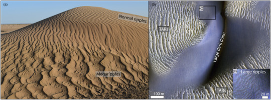


New theory that explains sand ripples on Mars and on Earth
Sand ripples are fascinating. They are symmetrical yet wind, which causes them, is very much not. Furthermore, they can be found on Mars and on Earth. They would be even more fascinating if the same effect found on Mars could be found here on Earth as well. What if one unified theory could explain their formation on two different planets of our solar system?
That is what Ben-Gurion University of the Negev physicist Prof. Hezi Yizhaq and Prof. Itzhak Katra and their colleagues from Denmark, Germany, Italy, China, and the US contend in a cover article published in Nature Geoscience (https://doi.org/10.1038/s41561-023-01348-3).
Sand ripples photographed on Mars by NASA's Curiosity rover in 2015 showed two distinct patterns – large ripples (meter scale) and a shorter "impact" ripples pattern (decimeter scale). The prevailing theory proposed since then argues that the smaller scale ripples are produced by the impact mechanism of the particles transported by the wind like normal ripples on Earth and the larger ripples form due to hydrodynamic instability like subaqueous ripples. Furthermore, it was believed that the physical conditions that produced them on Mars could not produce them on Earth.
However, Prof. Yizhaq and Prof. Katra have proven experimentally using Ben-Gurion University's wind tunnel and Aarhus University's Mars tunnel that such a phenomenon could exist on Earth – we just haven't noticed it yet because we didn't know we should be looking for it.
Imitating Martian sand was not easy because it's finer than sand here on Earth, explains Prof. Yizhaq, but the breakthrough occurred when they decided to try tiny glass balls to represent fine grains of sand.
Furthermore, the international research team has proposed a unified theoretical framework that would explain sand ripples on Mars and on Earth. At its most basic level, sand ripples on Mars caused by wind look like sand ripples on Earth caused by water.
"There is much more research, both fieldwork and experimentally, needed to prove our theory, but it is amazing to propose something so radically new in a field I have been studying for over 20 years. It is exciting to go out and try to find on Earth what can clearly be seen on Mars," says Prof. Yizhaq.
Prof. Yizhaq is a member of the Department of Solar Energy and Environmental Physics. Prof. Itzhak Katra is a member of the Department of Environmental, Geoinformatics and Urban Planning Sciences.
The research was supported by the Israel Science Foundation (Grant no. 1270/20), the German-Israel Foundation for Scientific Research and Development (GIF) (Grant no. 155-301.10/2018), the National Natural Science Foundation of China, Texas A&M Engineering Experiment Station, Europlanet grant no. 871149, and the Horizon 2020 Research and Innovation Program.
7 notes
·
View notes
Text
Navigating a Bright Career: All You Need to Know About MSc Geoinformatics Eligibility
Are you interested in pursuing a career in the field of geoinformatics? Geoinformatics is a rapidly growing field that combines geographic information systems (GIS) with other technologies, such as remote sensing, to collect, store, analyze, and visualize spatial data. This field has a wide range of applications, including natural resource management, urban planning, environmental monitoring, and disaster response.
If you're interested in a career in geoinformatics, an MSc in Geoinformatics can be a great way to get started. But before you apply, it's important to understand the eligibility requirements. In this article, we will discuss the eligibility criteria for pursuing an MSc in Geoinformatics and provide information on some of the top geoinformatics colleges in India.

MSc Geoinformatics: An Overview
MSc Geoinformatics is a postgraduate program designed to equip students with advanced knowledge and skills in geospatial technologies. The curriculum encompasses Geographic Information Systems (GIS), Remote Sensing, Global Positioning Systems (GPS), and Spatial Data Analysis. By enrolling in this program, aspiring geospatial professionals can gain expertise in utilising geoinformatics for a wide array of applications across diverse industries.
Eligibility Criteria for MSc Geoinformatics
MSc Geoinformatics eligibility varies from institute to institute. However, there are some standard requirements that most institutes have. These include:
The student must have completed their graduation in the Science stream from a recognised institute.
The graduation can be done in either of the fields of Science, Engineering, B.Arch, Mathematics, Economics, Statistics, Geology, etc.
They must have scored at least 55% aggregate at the qualifying exam of graduation.
There is no age limit for pursuing this course.
Some programs may also require that you have work experience in geoinformatics or a related field. If you don't have any work experience, you can demonstrate your skills by taking relevant courses or completing an internship.
Scope of MSc Geoinformatics
MSc Geoinformatics is a rapidly evolving field that combines advanced studies in an applied area of science and technology. It involves developing and using information science infrastructure to address problems in Geography, Cartography, Geosciences, and related branches of Science and Engineering.
Graduates of MSc Geoinformatics can find lucrative job opportunities as GIS Analysts, GIS Technicians, GIS Developers, GIS Professionals, etc. They can find employment in areas such as North East Space Application Centre, Indian Space Research Organisations, Space Application Centre, etc.
Top Geoinformatics Colleges in India
There are many top geoinformatics colleges in India that offer MSc Geoinformatics courses. One of the best colleges in India includes Symbiosis Institute of Geoinformatics. SIG is one of the top geoinformatics colleges in India that offers an MSc in Geoinformatics. Symbiosis Msc geoinformatics course is designed to provide students with a strong foundation in geospatial technologies and their applications.
Conclusion
In conclusion, if you meet the eligibility criteria for pursuing an MSc in Geoinformatics and are interested in this field, you should consider applying to one of the top geoinformatics colleges in India, including SIG. With a degree in geoinformatics, you can pursue a bright career in this rapidly evolving field.
0 notes
Text
Mining on Indigenous reservations in the Brazilian Amazon has increased 1,217% in the last 35 years

- By Elton Alisson , Agência FAPESP -
The last 35 years at the Brazilian Legal Amazon (an area spanning nine Brazilian states defined by federal law for environmental protection and developmental purposes) saw wildcat mining activities on Indigenous reservations expand from 7.45 square kilometers (km²) of occupied area in 1985 to 102.16 km² in 2020, a 1,217% increase.
All mining in these reservations is illegal. Wildcat prospecting in the Kayapó, Munduruku, and Yanomami reservations accounts for 95% of the total.
These are some of the key findings of a study conducted by researchers at Brazil’s National Space Research Institute (INPE) and the University of South Alabama (USA) in the United States. An article on the study is published in the journal Remote Sensing.
“We observed steady expansion of mining on Indigenous reservations between 1985 and 2020, with particularly fast growth from 2017 on. In that year, illegal mining activities occupied 35 km² of Indigenous land. By 2020, they had expanded to almost 103 km²,” Guilherme Augusto Verola Mataveli, first author of the article, told Agência FAPESP. Mataveli is currently a postdoctoral researcher in INPE’s Earth Observation and Geoinformatics Division and has a scholarship from FAPESP.
The other authors of the article include Michel Eustáquio Dantas Chaves, also a researcher at INPE, and Elton Vicente Escobar Silva, a PhD candidate at INPE.
To locate mining activities on Indigenous reservations, the researchers analyzed a dataset for the period 1985-2020 from MapBiomas, a collaborative network of NGOs, universities and tech startups that maps land use and land cover across Brazil.
MapBiomas provides annual land use and land cover maps for the entire Brazilian territory at a spatial resolution of 30 meters, based on automatic classification of Landsat images using the Random Forest machine learning algorithm.
“The system classifies images automatically and can distinguish between areas of forest with or without mining activities, especially areas where the soil is bare and the visible characteristics are quite different from areas with plant cover,” Mataveli said.
However, the system has some limitations when it comes to detecting mining activities on Indigenous reservations, such as the impossibility of classifying gold panning and similar activities carried out using equipment on boats anchored in rivers and smaller areas where the forest cover has not been cleared even though wildcat prospecting goes on there.
“The growth in mining on Indigenous reservations in the Brazilian Legal Amazon as detected by our study was alarming enough, but it was probably an underestimate given these limitations in the dataset we used,” Mataveli said.
Growing encroachment by illegal miners
The researchers found that gold is produced by 99.5% of the illegal mining operations on Indigenous reservations in the Amazon. The remaining 0.5% produces cassiterite, the ore from which tin is derived.
The growth of mining in the period was most intense on the Kayapó reservation, where it occupied an area of 77.1 km² in 2020, or almost 1,000% more than in 1985 (7.2 km²).
On the Munduruku reservation, it expanded from 4.6 km² in 2016 to 15.6 km² in 2020. On the Yanomami reservation, it expanded from 0.1 km² to 4.2 km² in the period.
“The government must intensify oversight, monitoring and law enforcement in these areas in order to halt the advance of illegal mining,” Mataveli said.
The Yanomami, living on a reservation demarcated in 1992, are the most isolated of the three communities, he added. For a long time, this isolation hindered encroachment by wildcat prospectors, but rising international gold prices and weakening protection of the Amazon in recent years have boosted investment in infrastructure for access to the area, which is protected by law. “The Yanomami reservation became the new frontier for illegal mining because of this combination of factors,” he said.
The area occupied by the activity on this reservation exceeded 2 km² for the first time in 2018, according to the study. Since then, encroachment and human rights violations have multiplied as illegal mining has advanced.
In 2022, the Federal Police (an agency of the Ministry of Justice in Brazil) observed a 505% increase in illegal mining along the Uraricoera River, a major artery for the Yanomami. Their leaders estimate that more than 20,000 wildcat prospectors have invaded the reservation. The Yanomami population is believed to total about 30,000. Malaria and other infectious diseases have spread swiftly in step with all this encroachment.
“The tragedy and humanitarian crisis we’re seeing now in the Yanomami community was perfectly predictable,” Mataveli said.
To reverse the trend, the first step should be to identify and monitor the Indigenous areas where illegal mining has increased most in recent years. It is also necessary to curb deforestation. Mining in the Amazon, including the Indigenous reservations there, occurs after the forest has been cleared, Mataveli noted.
“Illegal mining in the Amazon is very closely associated with deforestation because the forest has to be cleared before mining can begin,” he said.
The article “Mining is a growing threat within Indigenous lands of the Brazilian Amazon” is at: www.mdpi.com/2072-4292/14/16/4092.
This text was originally published by FAPESP Agency according to Creative Commons license CC-BY-NC-ND. Read the original here.
--
Read Also
Amazon forest: Disturbance is changing how plants are dispersed
#mining#illegal mining#brazil#amazon forest#yanomami#indigineous people#nature#biodiversity#forest#kayapó#munduruku#data science
2 notes
·
View notes
Last Seen Blogs

andminnequin
KatséQuin

2crimsonsun-blog
Малиновое Солнце

celestialtrolls-moved
.。・:*:・(ʘ ‿ ʘ✿)・:*:・。.


sevdenur
İsimsiz