#geomorphology
Text


Faraway views (right lens of my binoculars)
#pursuit 8x42mm if anyone is curious…#observations#mine#my photography#nature#ocean#newfoundland#island#atlantic ocean#canada#binoculars#film photography#ecology#geomorphology
41K notes
·
View notes
Photo
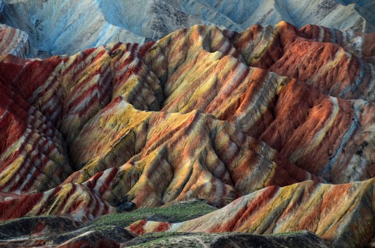
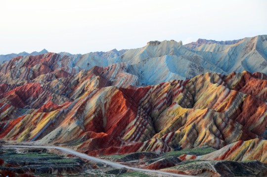

Danxia landform, China by Melinda Chan
7K notes
·
View notes
Text

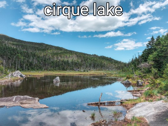
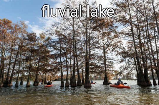

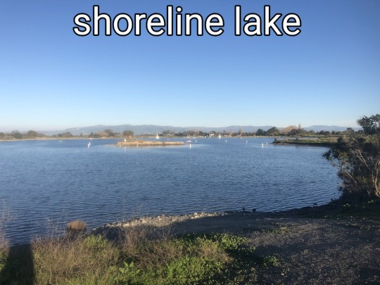
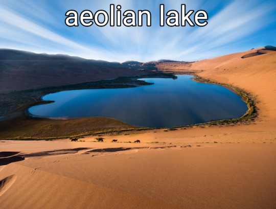
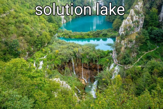


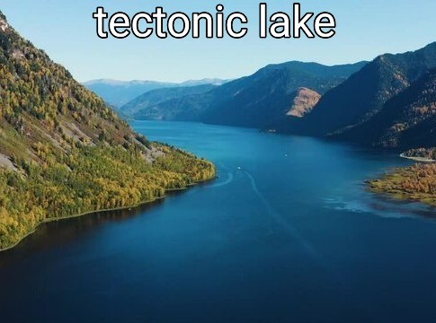
#lakes#lakeposting#poll#geology#geomorphology#nature#lake#naturecore#beautiful#limnology#science#ecology#aquatic ecology#water#meteor#meteorite#volcanic#glacier#glacial#tectonic#earth#environment#environmental science
2K notes
·
View notes
Note
do i.. WANT to know about the drumlins?
YES YOU DO
Drumlins are glacial landforms, which means you find them only in places that have been glaciated. And they're very distinct when you know what you're looking for.
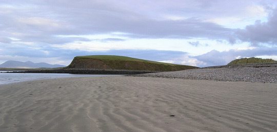
A hill with one steep side, one looooong sloping side, and you've (most likely) got yourself a drumlin. (Unless it's small. Drumlins are tens of meters high and hundreds of meters long, so if you've got a short one with way more elongation, you've got a drumlinoid.) They're all over Canada,the north eastern US, and northern Europe. The one pictured above is in Ireland. The ones in Canada and the US formed as the Laurentide Ice Sheet, a kilometers thick mass of glacial ice, was spreading across North America during the Last Glacial Maximum
There are lots of really cool glacial landforms (eskers and kames and lakes (Glacial Lake Agassiz my beloved) and like a dozen types of moraine), but drumlins are my favourite because they're so incredibly easy to identify, they occur in swarms, and they're kinda weird as hell
There's still some debate among geomorphologists about how, exactly, they form but I was told that the (mindbogglingly huge mass of) ice catches on a sticky uppy bit of bedrock and instead of mowing it down like a child kicking over a stack of blocks, moves around it instead. And because there's now a place behind the bedrock where there's less ice, the ice drops a whole bunch of glacial till (all the bits of sediment that did get mowed down like a child kicking over a stack of blocks) on the other side of the bedrock bit

(This is a constructional theory, where the drumlin is built up. the other main one is the erosional theory, where everything but the drumlin is eroded. There's also a theory that drumlins are deposited by subglacial meltwater, but that one is highly controversial)
"Now wait," I hear you say, "go back a bit. What the fuck was that about swarms?"
They occur in swarms.

If you've got one drumlin, good chances you've got a lot of drumlins. Which is actually amazing, because the steep side of the drumlin faces the direction of flow, which means we know exactly how the ice sheet moved. In this image, for example, the ice started at the top, near Lake Ontario, and then moved south. From looking at drumlins (and other glacial landforms, we do like to have multiple reference points), we know that the Laurentide Ice Sheet started in the Hudson Bay and crept out from there
And because they're so distinct (tear drop shaped, made of till, occur in swarms), and because drumlins can only have been made by glacial activity, we can look all over the world and find these things and know that this place was once under several thousand tonnes of ice

Not during the Last Glacial Maximum, but definitely ones before it. And I just think that's neat
#'glacial till' I say as if all till isn't glacial#that's only in there for the non-geologists tbh#I love drumlins so much#they're neat#rocks#long post#Loxie has words#geology#geomorphology#These thing can be made of some weird things too#Here in Alberta we're on carbonate rock#because of that ocean that used to be here before BC crashed into us#but we've got granite in our till deposits#which was imported here by the glacier express from Ontario#where the Canadian Shield is exposed#the Shield which is made of granite and other igneous rocks#(we've got granite too but it's buried *deep* beneath the carbonate)
222 notes
·
View notes
Photo

Flame Azalea flashing their bright orange coloring against a lush green backdrop of North Carolina mountains underneath a blue sky of building clouds. Roan Highlands, Southern Appalachian Mountains. Carter, Tennessee. Photo by Mark van Dyke.
236 notes
·
View notes
Text
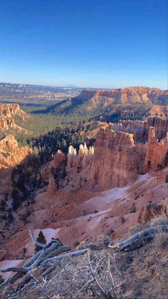
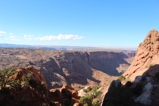
Bryce hike!
#mine#travel#nature#life#photography#scenic#hike#adventure#national parks#utah#bryce canyon#geomorphology#earth#landscape
37 notes
·
View notes
Text
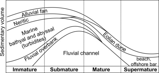
Knickpoints, base level, and waterfalls
I won't go into detail about hydraulics, but hi! Let's talk about rivers a little!
Base level: in geomorphology, the "base level" is the lowest point at which erosion can occur, or in the case of rivers, it's the lowest altitude at which a river can flow. A common base level for most rivers is the sea, though for some of them it might be a lake, a different river that the first river is a tributary to, or a dam.
The base level for any given river can change through time, since sea levels can vary, dams can be built, etc. A variation in base level, causes a variation in the river's energy, which can lead to more erosion, or more sediment deposition depending on if the river has more or less energy than before.
Here are two examples, the first is of a river whose base level dropped lower, it gained more energy and started eroding the substrate more, the second one is of a river whose base level was raised higher, and it started depositing more sediment to compensare with lowered energy.
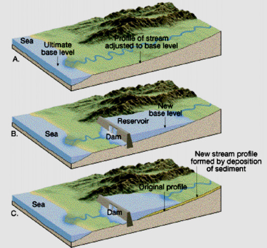
This was an introduction to explain the concept of base level, now let's move on to knickpoints.
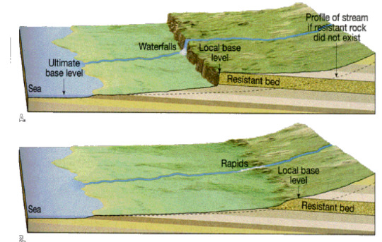
Knickpoint: a sudden and sharp variation of a river's slope, often leading to the formation of waterfalls and/or lakes. Some reasons why a knickpoint might form are: base level drop, tectonic activity, or a later of erosionally resistant rock:

There are generally two types of knickpoints: migrating and fixed.
Migrating knickpoints are mainly caused by base level drop and tectonic activity. They are called migrating because due to the erosion that the river applies on the substrate, the knickpoint is able to travel upstream. In the case of a base level drop type of knickpoint that affects an entire hydrography basins, usually the baisin will have all of its migrating knickpoints at the same altitude:

Sometimes, knickpoints are caused by differential uplift (two areas within a hydrographic basin are subject to different rates of tectonic uplift), and this causes a "barrier" of knickpoints that can easily be drawn within the baisin:
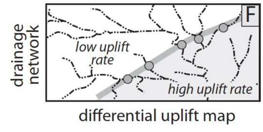
Fixed knickpoints instead are caused mostly by the presence of a layer of erosionally resistant rock, as it is something that the river cannot easily erode through, and will remain fixed.

Waterfalls can form from any of these kinds of knickpoints, it really depends on the river's erosion ability, it's energy, it's mass flow rate, the kind of sediments it carries, etc.
#geomorphology#original post#geology#this one was kinda dumb lol sorry but this exact topic kicked my ass yesterday
43 notes
·
View notes
Text
I wrote this years ago about Worldbuilding
This is a repost from an old article I wrote on my ReshapingReality.org blog back in the day. This is the step-by-step process that I use in worldbuilding. You don't have to follow my process, but I figured it might be a good start for some writers.
To see my primary setting for my original science fiction stories as an example, I have imported 66% of my notes to my Elivera Wiki, and plan to finish importing my notes in the next year or two.
NOTE: To adapt these steps to Fantasy that has magic, the step for the magic system must include the rules of how the magic works, its strengths and weaknesses, its impact on the world/society/technology/people/culture, and its limitations. Technology is very similar in a way to magic as technology also has limitations, strengths, weaknesses, and impacts to world/society/environment/people/culture that needs addressed.
World-building 101 for Science Fiction
Whenever I world-build I start with the basics. First I need a solar system. You can take the easy way out and just use our home system, or you can build your own. If you wish to build your own, these are the steps to follow to create a fairly scientifically accurate system:
Determine what type of star will be the sun for your system. The star will determine where you can place your planet for it to be habital, it will also determine the color the star shows in the planet's skies, the radiation that impacts it, and other important attributes that effect the environment of the planet. See my blog entry here that discusses this in more detail: Worldbuilding Series Part One – a star
Once you have your star, you can focus on your planets. Read this for more information: Worldbuilding Series Part Two – the planets. To help you build both your star and planet, I’ve created a template for your world-building needs. Input in the data to have the spreadsheet generate some basic attributes that you can use in the astronomical data of your system: World-building template
Part of the process in creating planets involves the planet’s geology. The environment in which people live impact not only how they subsist but also how they build up their community, the types of buildings that would work well, what resources they have available, and how they use those resources. This post focuses more on terrestrial planets, but it does highlight some guidelines for gas giants as well: Worldbuilding Series Part Three – Planet Geology.
Now it’s important to focus in on the atmosphere of planets (if they have one) and their natural cycles. This impacts seasons, natural disasters, storms, weather patterns, long-term climate change, etc. All of which will impact the people who live on your planet. Here is my entry on this: Worldbuilding Series Part Four – Atmospheres and Natural Cycles.
The features of the planet will play a large role in the development of the sentient species’ culture and their evolution. This post highlights how to create features on the planet and how this process works: Worldbuilding Series Part Five – Geomorphology. It may be useful to take a look at my map-making post in order to create a map of the surface of your planet.
Finally, the sentient species themselves. If they are humans, this simplifies matters, and you mostly have to worry about how humanity adapts to the planet you created. This post discusses the effects of environment on a culture: Effects of Environment. You’d also have to consider the dynamics of diversity, which I highlight in this blog post (focusing more on a future earth dynamic but can be applied to humans migrating to new worlds as well): Diversity – Race. If you are creating a new aliens species, this blog post discusses some of the factors to keep in mind and offers some suggestions on how this can be done: The Science of Aliens.
Another important factor to consider is how language can influence a culture and its development. I discuss how language intersects world-building in this article: Languages and World-building. To help you create your language, examine these posts: How I craft a Language part 1 and How I craft a Language part 2.
Now remember each step above doesn't require indepth analysis and a million words of worldbuilding to complete. Sometimes all you need is some basic descriptions and ideas. From those you can then fine-tune what areas need more development so it can fit the needs of the stories you wish to write.
For example, you'll eventually need to write more about the following topics below, but focusing on which needs extensive development and which need only a brief primer can be difficult to decide! But the best way forward is to think about the stories you wish to write, and focus on the details you need to create a story that will immerse the reader in your world. Then develop those details.
Politics and Government
Diplomacy and Espionage
Economics
Education
Daily Life
Technology and Research
Cities and their infrastructure
Philosophy and Cultural Values (See this post: Thoughts on Philosophy within World building )
For some creative questions to delve deeper see: fantasy world-building question list compiled by Patricia C. Wrede. The above list compiled by Patricia C. Wrede is very much usable for science fiction writers — just focus on the questions that deal with creating a world and a culture and when you encounter the magic questions alter them to technology.
Maps
Another important aspect of worldbuilding is maps. Creating maps of your world and of your cities can be incredibly helpful with visualizing your world. It also helps track the character(s) journey across a region, the distances involved, the time needed, the environments crossed, etc.
For an example, I often create a zone map for my cities. Here is a detailed post on how to create a map: World-build: Maps
Character Design
This is just a placeholder for any primers I wrote for character design:
Primer for writing trans characters
Character Template
Resources
Books:
Wonderbook by Jeff Vandermeer
Worldbuilding by Stephen Gillett
Body Trauma: A Writer’s Guide to wounds and injuries by David W. Page, MD, FACS
The Writer’s Guide to Weapons by Benjamin Sobieck
Forensics for Writers by D.P. Lyle, M.D.
The Science of Aliens by Clifford Pickover
The Writer’s Guide to Psychology by Carolyn Kaufman, Psy.D
Space Travel by Ben Bova with Anthony R. Lewis
The Starflight Handbook: A Pioneer’s Guide to Interstellar Travel by Eugene F. Mallove and Gregory L. Matloff
The Language Construction Kit by Mark Rosenfelder
Advanced Language Construction by Mark Rosenfelder
Worlds of Wonder: How to Write Science Fiction & Fantasy by David Gerrold
The Planet Construction Book by Mark Rosenfelder
Building Imaginary Worlds by Mark Wolf
Revisiting Imaginary Worlds by Mark Wolf
The Kobold Guide to Worldbuilding by Wolfgang Bauer
On Writing and Worldbuilding by Tim Hickson
Classes/Podcasts
N.K. Jemisen's Masterclass on Writing and Worldbuilding
Roxanne Gay's Masterclass on Writing
Neil Gaiman's Masterclass on Writing and Storytelling
Levar Burton's Masterclass on Storytelling
WorldAnvil Worldbuilding Podcast
Writing Excuses Podcast
Worldbuilding Magazines Podcast
Brandon Sanderson's Writing Class
Worldbuilding Tips by Jenna Moreci
Common Worldbuilding Mistakes by Yinka
Overly Sarcastic Productions' Trope Talks
Feminist Frequency
Feel free to ask questions and share more resources or tips!
#Worldbuilding#speculative fiction#science fiction#Science Fiction Worldbuilding#Planets#geology#geomorphology#Various types of maps for worldbuilding#Resources on worldbuilding#worldbuilding tips#writing tips#writing#writing advice#sci fi writing#sci fi
17 notes
·
View notes
Photo
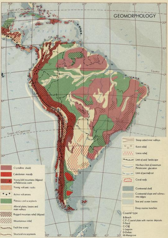
Geomorphology of South America
122 notes
·
View notes
Text
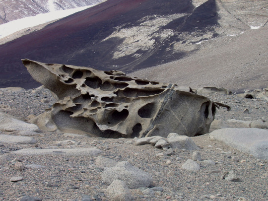
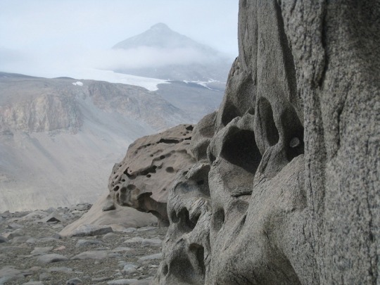

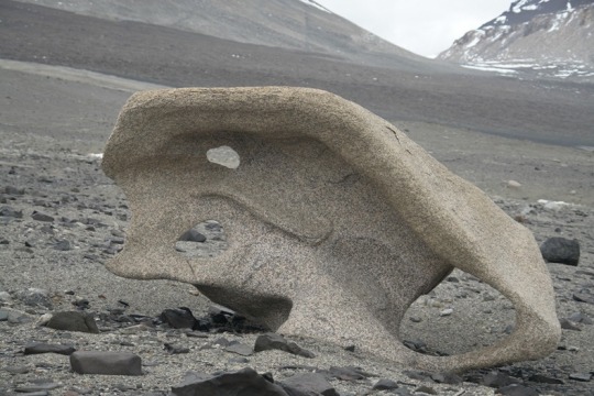
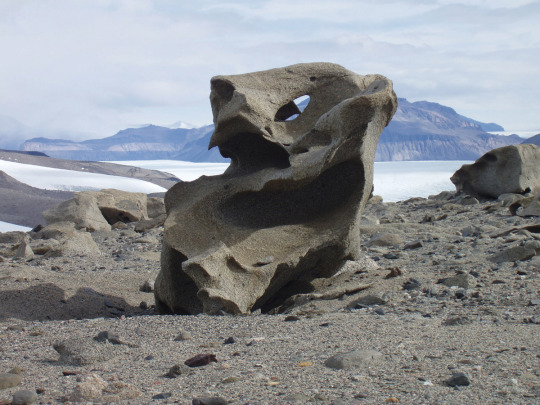
The aeolian processes of katabatic winds in Antarctica’s McMurdo Dry Valleys shape boulders into surreal formations
#ultimate life goal is to visit here#antarctica#mcmurdo station#mcmurdo dry valleys#desert#geomorphology#geology#rocks#aeolian processes#aeolian landform#earth science
90 notes
·
View notes
Text
So as it turns out, Plato was very consistent about the geomorphology of Atlantis
A lot has been said about Atlantis, but not much attention is paid to what that island actually was. It's a shame everybody talks about aliens but not igneous rocks :(
In the original text, called Critias, amongst the description of this perfect society placed there by the hand of Neptune and swallowed by the sea as punishment for their hubris, there is a surprising amount of detail about the morphology of Atlantis, especially its geology.
In terms of size, it is said the Island is bigger than Libya and Asia. These names are the ancient equivalents of the modern regions we call north Africa and the near east (roughly between the eastern shore of the Aegean and Persia). The measurements that are given concretely are given in stadia. The size of this measurement changes based on the time and place, but I'll use attic stadia since that's where Critias was from, it's equivalent to 177.6 meters. Attica is the region of Greece where Athens is, northeast of the Peloponnese peninsula. The distance between the center of the island and the sea is 335km, equivalent to about 2 Corsicas' length.
It is "beyond Heracles' pillars", which means the strait of Gibraltar, the limit of westwards Greek geographical knowledge. The civilization that lived in the island was centered on rectangular shaped plains, surrounded by mountains and, at its center, lay a moderately sized hill. The entire island is raised considerably off the sea, so its shores were like cliffs. The climate is implied to be subtropical, somewhat warm, and with plentiful rain in the winter but not that much in the summer.
Regarding the metals, I'll try to summarize as much as I can because it's kind of a lot. The main resource present at Atlantis is orichalcum, we don't know for certain what it was, but it's generally accepted that it was a zinc-copper alloy, almost as valued as gold because of its long lasting shine. Plato says this alloy was extracted directly from the island, but for simplicity's sake I chose to interpret it as copper and zinc being very abundant. The other metals which are mentioned are bronze, tin, gold, and silver. Plato doesn't go into nearly much detail about the rocks they used, and only says white and black rocks. This, as you'll see, isn't that bad of a hint.
My first instinct about the morphology of this place was a plateau whose center was eroded away, leaving a bowl-like shape, where the edges of the original plateau act as mountains. This would even explain the lower mountain in the middle, as it would be an almost fully eroded mesa, left from the original plateau

However, the mountains are described as tall and impressive, which isn't exactly what this is.
So, my second thought was the alpine orogeny. This was a generalized increase in the frequency and force of tectonic shifts, which makes up the tertiary geological era. This was the origin of the highest and youngest mountain ranges in the world. From the Pyrenees, through the Alps, Carpathians, Caucasus, Alborz and to the Himalayas, there is an almost unbroken chain of mountain ranges formed at the same (geological) time. These mountain ranges generally have dramatic changes in incline, compared to older ones like the Urals or Appalachians. And most importantly, this violent tectonic activity usually also includes a lot of volcanic activity, where our favorite igneous rocks form by cooling down by coming into contact with the crust's rocks, the air, or water.
Now it turns interesting. Copper is mainly found within igneous rocks, mostly granites (granite is a lot of colors but one of them is white) during subduction of the tectonic plates. Copper also forms when hydrothermal fluids cool down. It can be formed through sedimentary means, but in less abundance and not particularly relevant to our case. Zinc, however, only forms when ocean water interacts with hydrothermal fluids, in what's known as sedimentary exhalative deposits. When this happens, zinc associates with sedimentary rocks such as LIMESTONE and DARK LUTITES. These are white and black rocks.
Just from these two metals we can intuit that Atlantis used to be half-submerged in the ocean and then rose above sea levels. Also, the hydrothermal vents suggest it's near the border between tectonic plates, where the mantle escapes more often into the crust. But we aren't done with metals
Tin is found primarily within cassiterite, an igneous mineral which crystalizes near hydrothermal vents and inside gneiss and GRANITE. Silver is also commonly formed from hydrothermal fluids. And when it's not, it's formed in magmatic processes alongside COPPER AND ZINC. And if that's not enough, silver also forms sedimentary inside LIMESTONE and LUTITES. Last of all, gold. Do you know how 80% of gold in the Earth formed? When there is an especially violent seismic shift in the earth, whether because of earthquakes or orogenesis, some cavities form inside the crust, where there is a sudden drop in pressure, and if there are certain fluids in these cavities, they will almost instantaneously sublimate into a gas, which then crystalizes into quartz veins that are also filled with gold deposits.

are you seeing this.
And this is not all. With what little detail we are given about the climate of Atlantis, we can figure out if it's in the north or south Atlantic. Let's look at some climographs.
First, the south Atlantic, take the island of Saint Helena as an example. This graph shows the average temperatures and precipitation in a given location throughout (typically) 50 years, broken down by months.
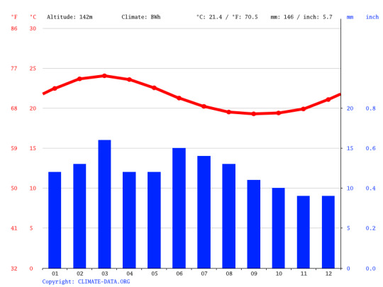
Its rains are very consistent, but extremely scarce, averaging around 10mm per month. And actually, according to Wladimir Köppen's classification, Bwh, it is a desert-like, subtropical climate. Not really what Atlantis is like.
For the north Atlantic, let's look at the Azores, an archipelago.
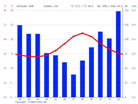
This is more like it. Abundant rains in the winter, almost reaching 150mm in December (more than what Saint Helena gets in a year). It's still fairly warm, and the summers are drier. Köppen classifies this as Csa.
And it just would so happen that the Atlantic ocean has a ridge running along its length, where the Eurasian and north American plates meet. It is very seismically and magmatically active, has plenty of hydrothermal vents, and has been constantly bringing out new rocks from the mantle ever since Pangea broke up and Afro-Eurasia drifted away from the Americas. Here is a very exaggerated render of what it looks like

You can see the Azores here, they are just east of the ridge, at the same latitude of southern Portugal.
Anyhow, so after looking at all of this, we can reconstruct roughly how the island of Atlantis formed:
Before the alpine orogenesis, a volcano erupted near the mid-Atlantic ridge. This brought out a lot of volcanic rocks, such as basalt. Some of them over sea level, but most of it under the sea. In this time, hydrothermal fluids rich in silver, zinc, tin and copper, are deposited on top of this new platform. When the alpine orogenesis begins to create massive mountain ranges across Eurasia, the platform created by the volcano is lifted upwards, creating a plateau surrounded by mountain ranges, and in the middle of the island, what's left of the old volcano gets gradually eroded away into a tall hill. This massive tectonic shift pushed many igneous rocks near the surface, such as granites, basalt, gneiss, and rhyolite. Either because of this push, or due to a later earthquake, a lot of quartz-gold veins are formed within the new island. Finally, erosion and sedimentation by the newly-formed rivers eventually turned the hydrothermal materials into limestone and lutite.
Ok so this is all fiction, and there is no lost island the size of north Africa in the north Atlantic. But isn't it really surprising that, in a metaphor about over-expenditure in the military, Plato described such a geomorphologically coherent continent? That basically all of the metals that were in abundance in Atlantis could all be created by the same couple of processes?
#köppen my beloved#this is a rant version of an essay for class#hope this is coherent because I am not reading all of that again#geography#geomorphology#atlantis#i have 34 tabs open lol
7 notes
·
View notes
Text
15.03.24
I haven't updated for a long time about my studies and here I am, friday night, doing a geomorphology assignment. i still have nine days to finish it but I'm doing well! i want this assignment to be the best! also I've been thinking about social media quitting, but not like people do. i can't explain. i don't want to live in a cave, but use only when it's necessary and not lose a lot of time in front of screens... or at least doing something useful.
idk exactly how i will make it work but I'll find a way hahahaha
🎧 soundtrack:
5 notes
·
View notes
Text
Science Saturday: Feldspars, Sandstones, and Dating
Did you know that you can use feldspars to tell you how old a rock is? Did you know they can tell you about how long a paleo river is?

That's okay! Let me tell you about it then! So, due to the unstable nature of feldspars they can be used in a special method to date rocks called luminescence.

Luminescence dating is used to determine how long ago mineral grains were last exposed to light.
This is generally only used for surface dating usually in storm or tsunami deposits so scientists can see how much sediment gets moved.
As for river length, here's how we figure that out. River's deposit sand. Over time, sand is compressed into sandstone. Sandstones are categorized by the amount of quartz, feldspar and lithics (rock fragments) that are present.

Arkose or arkosic sandstone refers to sandstone with at least 25% feldspar composition. Arkose usually forms from the weathering of granite and must be deposited rapidly to avoid hydrolysis (check out last Science Saturday).

Now, because it has to be deposited quickly, this means that arkose occurs very close to the source rock. We call this a texturally immature sandstone.

Not that kind of immature. Immature in the sense that it got buried young. If you look at a river diagram, arkose occur near the head of the river either in conglomerates or very course sands. By the time you get the river delta, usually all that is left is quartz.
Thanks for joining me for a science lesson this weekend. If you want more content go check our my other social media platforms:
#geology#fun facts#mineralogy#feldspar#minerals#science#immature#lithics#quartz#granite#geomorphology
6 notes
·
View notes
Photo

Blue Ridge Parkway in North Carolina.
172 notes
·
View notes
Text


could be anywhere by now
#travel#nature#scenic#landscape#adventure#rocks#photography#geomorphology#earth#life#roadtrip#utah#landscapes
20 notes
·
View notes
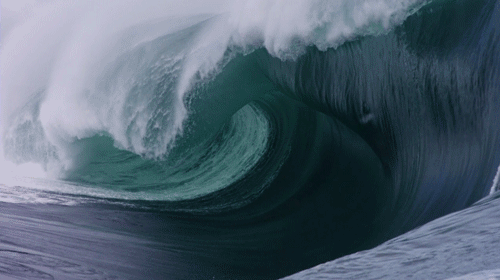
Text
Awesome! 🧊🗻🌊🛥
115 notes
·
View notes
Last Seen Blogs

drumline-jesus
Call me DJ.

flush-it-down
Flush-it-Down

isarkind-blog
isarkind

q8sonu
Nature Lovers

forbiddensnackster
Crunchmunchmunch