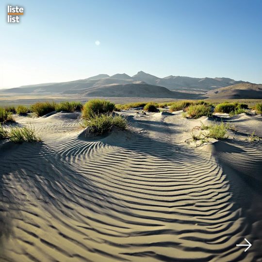
#glacial basin
Photo
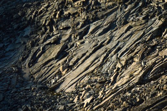
Granite ridge detail. Pinnacles Lakes Basin, John Muir Wilderness, Sierra Nevada Mountains, California, USA Photo by Van Miller
#igneous rock#granite#geology#rocks#glacial exfoliation#pinnacles lakes basin#john muir wilderness#Sierra Nevada Mountains#mountains#california#©Van Miller#hiking#backpacking#travel#camping#Wanderlust#Wilderness#the wilderness journals#photography
38 notes
·
View notes
Text
if i understand correctly, the boreal taiga biome 1) is the largest land biome on earth by area; 2) did not exist before 12,000 years ago, when humans hunted mammoths to extinction, and the mammoth steppe yielded to encroaching forests. pockets of the former mammoth steppe now exist in places like the ukok plateau and the uvs lake basin, but during the last glacial maximum they stretched from the iberian peninsula to beringia and into the yukon
168 notes
·
View notes
Text
Spectember D6: Allen's Rule
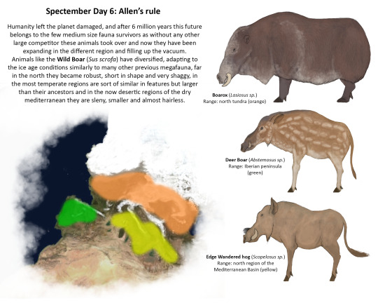
6 million years since humans perished alongside the 50% of the biosphere, earth has recovered though not fully, there is just a handful of megafauna animals that are above a ton descendant of the animals that thrived in the post-human disaster, descendant of invasive and domesticated fauna in some places, others very resilient that were more used to the urbanization of their original terrains and the sudden climatic change for centuries, between these are the descendants of the wild hogs that endured the harsh habitable conditions until the end of humanity, and now with them gone they started to take the empty niches left by all the large herbivores of the Pleistocene and Holocene in Europe. Is not an easy time, the glacial age hasn’t ended yet, and now with the total disappearance of the Mediterranean Sea the once fertile south part of Europe is now more than scattered semi-arid regions.
Hogs have been always strong generalists but the strange conditions of three radically different environments have pushed them to change morphologically depending of the biomes each population managed to adapt, in the far north there are the smaller robust tundra species, the Boarox (Lasiosus sp.) has developed a large coat with a good chunk of fat that help them preserve the heat for the extreme wind storms on the strongest winters, they now resemble a muskox in shape, but unlike those they do not posses robust horns and a very tall head but a wide snout strong lips to tear the vegetation in the snow and large curved tusks protruding of each side help it to plow through the terrain.
Going now to the temperate regions there is something more familiar to the ancestral hogs, but taller, even more gracile and with a shorter coat, Deer Boar (Abstemosus sp.) is something like a suid trying to be a ruminant, has a divergent color pattern that helps them to blend with their environment which derives of the young individual coat, as well their heads are elongate, their ears longer and their snouts narrower than their north relatives, these are more browsers than grazers, a population is increasingly becoming isolated in the once Iberic peninsula.
And finally in the limits of the continent, in the edges of the now permanent dry basin of the Mediterranean there is another species, smaller than the temperate ones, lankier in shape this is the Edge Wandered hog (Scopelosus sp.), a species that resemble the long extinct African savannah species but that inhabit what was once a region covered by a sea. Their ears are larger than their previous relatives, more to accommodate for the heat, their legs are sort of slendy with considerable taller hooves, their coat is very short, with a muted and dull coloration more fitting for this environment, their heads are not as long as their relatives but wider, with short snouts but longer horns, these are more suited to dig for tubers and burrowing insects.
Each of these species are flexing the adaptive potential that suids are fully exploiting as they have claimed this recovering world, one that humanity left it devastated by a mass extinction.
73 notes
·
View notes
Text


I had a realization while playing the new Pokemon DLC
These are pictures of the areas surrounding the four shrines containing the ruinous quartet, and now that I'm looking for it, I can see evidence of each one on the local environment.
>Chi-Yu's shrine is surrounded by massive spires of blasted obsidian sprouting from solid rock
>Chien-Pao's shrine is surrounded by striations and gouge marks in the mountainside that're highly reminiscent of glacial retreat marks and ice-erosion
>Wo-Chien's shrine is at the bottom of a massive basin filled with irregular, atypical lakes and ponds, that look to have been gouged out of the ground itself
>Ting-Lu's shrine is underneath a massive rock formation sitting in the middle of a lowland plain - a rock formation with no natural plantlife, and totally disconnected from the natural mountains of Paldea
Like holy shit, the name "Ruinous Quartet" is not an exaggeration! I would fully believe these four pokemon alone were enough to cause an extinction event in Paldea's past, we can still see the catastrophic effects of their power!
#pokemon#pokemon scarlet and violet#ruinous quartet#chi yu#chien pao#wo chien#ting lu#this is some A+ environmental storytelling!!#the games always say legendaries are these superpowered demigod beings#but usually its just them doing something impressive in cutscenes#THIS is not a cutscene!
53 notes
·
View notes
Text
Reyal At A Glance - Climate

Map by @nexelart (twit)
Reyal - A World of Extremes
As per the previous post stated, Reyal is much like our own Earth in terms of biodiversity, as well as a few other traits. In this post, we'll explore Reyal's weather and biosphere a bit more!
Reyal's climate has shifted greatly during it's history. From the early start of life, it was a much hotter world; it's atmosphere used to contain much higher amounts of carbon dioxide and other greenhouse gasses, making it a much more tropical world than it is today.
Nowadays, Reyal experiences a much colder climate than Earth, as it lost much of it's greenhouse gasses during its several billion year long evolution. On top of this, Reyal orbits a bit further out from Tenav's habitable zone than we do around our own Sol.
At the poles, including wind chill, temperatures drop down to -103c on average at the surface. At the equator, the highest you can expect is a balmy 27c. Weather can of course influence these temperatures, but thanks to Reyal's lack of seasons and relative climatic stability, these tend to be year-round temperatures.
Thanks to it's colder climate, most of the planet is dominated by humid continental biomes, as well taiga and tundra. Due to a lack of water compared to Earth, most of the equator tends to be dominated by savanna and desert, with only a few key areas near the equator bearing rainforests.
Life has taken a massive advantage of this stability, and as such, Reyal can be very well described as a garden planet. Flowers and fruiting plants tend to grow very rapidly, leading to an abundance of food and other biological resources.
This all works out perfectly for the Lyratet, however, as they have evolved to be more adapted to colder climates. Due to their thick fur, habitation near or on the equator is near impossible, lest they suffer from the effects of overheating. Only a few settlements exist in the equator, and are primarily underground. Despite the heat, some do inhabit the surface briefly during the night or Tenavset/rise.

Edit of @nexelart's map, showing the equator and northernmost/southernmost parts of the poles greyed out
As seen in the image above, this excludes a fairly large part of Reyal for habitation. Most of the equator is designated as a ecological reserve then, with very little being known about it. Scientists do mount expeditions to document flora and fauna, but more often than not, the region is left to itself.
This lack of habitability at the equator has greatly affected Lyratet history. For almost the entirety of the two hundred thousand years that they have first had cultures, they had no real means of accessing the northern hemisphere. As such, they were relegated to the south, and struggled to develop for much of their history.
In what would be 1113 A.D. our calendar, two brave souls finally took it upon themselves to transfer through the mountain ranges that intersect with the Great Desert Rings, and set foot up north. This is a story for another time, though!
In the next post, we'll be exploring the origin land of the Lyratet; the Land of Tenav's Dawn.
Directory: Intro | Climate | the Land of Tenav's Dawn | the Desert Rings | Therikine | the Great Central Desert Mountains | the North Glacial Plains | the Yuniv-Semat Basin | Juleg Marrdev Technocracy | Yuniv-Semat Trail | Ro | Velgae
#my posts#reyal#reyal at a glance#worldbuilding#creative writing#writeblr#speculative evolution#spec evo#sophonts#aliens#as we go along#awga
30 notes
·
View notes
Text

Lake Ōhau is a glacial lake in the Mackenzie Basin of the Waitaki District on the South Island of New Zealand
123 notes
·
View notes
Text
One More Thing
Al-an was only humoring her. As much as he desired that same hope that Robin seemed driven by, to allow himself to become enveloped in it like it enveloped her, it never came. Instead, he was faced with a grim reality.
Robin had suggested that they go and make a replica of the cure before they left for Al-an’s homeworld. Robin had argued “it could help you make amends”. According to what they synthesized, it wouldn’t be too difficult to locate and deconstruct the various flora the antidote called for. So, Al-an had agreed.
What he hadn’t told her is that he’d already considered that. He’d already had that thought mull through his head a thousand times - but each time he was hit with a wall.
If his people were alive, they would surely already have a cure by now. By the time he was infected, their efforts were already tireless – there was no other point of focus within the Network, they needed an antidote.
More likely, however, his people were no more.
Throughout their explorations, they had discovered, scanned, and dissected every piece of Architect technology they had come across, and yet Al-an had gotten nothing definitive about his Network at all. All he had been able to derive from it all were useless threads that, no matter how long, had always dissipated and left them empty-handed. The only thread that remained led them through the Phase Gate, the gateway to his homeworld. A daunting task.
So, perhaps that’s why he decided to go along with Robin’s idea, didn’t argue his point - he was scared. Not that he would ever admit it, but… it felt far too easy. He’d battled a millennia for these answers, and now suddenly they were so close. The anxiety of finally being one door away from finding out was almost as drowning as the anxiety of not knowing whether or not he ever would be able to.
And maybe, just maybe, an even smaller part of him was dragged under that blanket of hope Robin was under. The soft, warm embrace of it seemed impossible to evade, no matter how statistically unlikely this hope was. And truly, ‘lying down and giving up” as Robin had said would be a much worse inefficiency by far than holding onto this belief, no matter how unlikely.
So, maybe that’s why he was looking through the trees of the glacial basin with Robin for something he thought fruitless. Even if he was sort of worried she was freezing her ass off.
“Robin, it seems unnecessary that we search now. It is almost night and I predict we are experiencing the start of a blizzard.” There was an edge of urgency in his voice, but he kept his tone gentle.
“What? You cold?” Robin grinned and shot him a look - though her teeth were chattering so much she could barely get the sentence out. She rubbed her gloved hands together and held them close, shivering.
Al-an let out a noise akin to a sigh and approached her with an elegant stride, standing between her and the direction of the snowfall.
“I am resistant to more drastic temperatures than you are. I have far more energy within me to regulate my internal temperature and my tissues are very insulative.” Al-an led one of his mechanical arms towards her and grasped her in his anti-gravity beam. He placed her on his back. Gently, he added “I am not cold.”
Robin, honestly freezing, immediately wrapped her arms around Al-an’s waist, enjoying the warmth radiating off of him. “Okay,” Robin said through clenched teeth, “since you’re cold we can go back to base.”
Al-an produced a hum of disapproval but was pleased that he had managed to convince her so easily. “As you wish.” he offered, noting the way she leaned into him. She must be tired, he considered. They had been searching since early morning.
“Brace yourself.” Al-an warned as he steadied himself, preparing to blink across the land.
He hadn’t carried Robin on his back before and it was a slightly uncomfortable sensation, the pressure of her weight was unknown to him. He took Robin’s tightening grip as a sign she was ready and began to make his way across the land.
At first, things were okay - but they took a pretty drastic turn when Al-an blinked right in front of an emerging ice worm.
Stumbling back, Al-an tried to find his footing over the shaking ground, but Robin had already lost her grip and fallen off with the momentum.
She sat on the ground, stunned from the sudden change of pace. Night had already almost fully enveloped the sky and visibility was low - Al-an frantically calculated how to evade the situation, putting a foot forward to snatch Robin out from the ice worm’s trajectory.
However, he was not accounting for Robin’s scream and attempt to roll out of the way - which caused him to miss her as he blinked towards her. Al-an dug his heels into the snow and turned around, but not quick enough.
The ice worm simply followed its plan of attack and lurched forward, smashing into Robin and burying itself in the ground in front of her. And that was it. It was gone. And all Al-an did was watch helplessly.
He cursed himself as he blinked back over to Robin and crouched down in front of her to get a better look at her injuries. She was panting and biting her lip, gripping her outer thigh.
“Robin,” Al-an hurriedly moved her hand out of the way and felt a wave of guilt crash over him as he saw fresh blood leak out of the open wound.
“Its skin was like sandpaper,” Robin informed him, face clenched as she tried to suppress the pain.
But Al-an wasn’t paying attention. He grabbed a first aid kit that had fallen from her bag and opened it, quickly handing the roll of gauze within it to one of his mechanical hands. He muttered an apology as he used his claws to open a water bottle and flush the wound with the cold water, which garnered him an unhappy groan from Robin. He used the roll of gauze to wrap her thigh and just like that, in 45 seconds, he had her up in his anti-gravity beam and was blinking towards their base at a rapid pace.
He went up through the moon pool and lowered her onto her bed, crouching down again and using his mechanical hands and scanner to look her up and down for any more injuries. Fortunately, it seems he had managed to evade her going into shock by staunching the blood loss quickly and she only had mild scrapes on her lower leg and arm, but her protective wetsuit was utterly torn. He went to work removing it from her but she yelped, “Al-an!”
Al-an froze and looked at her. In the position he was in, they were eye level with each other - something they certainly didn’t often experience. Robin protectively held onto her clothing. “Al-an, you can’t just strip me naked just like that -“ he cut her off.
“Robin, you are injured. I’m tending to you and to do this I must remove your wetsuit.” Al-an had a breathless sense of seriousness in his voice and he spoke quickly. “It has been breached. I must remove it, assess your other injuries, and disinfect them.”
“I’m fine! I can tend to myself!” Al-an was acutely aware of how her heart rate was increasing and adrenaline was pumping steadily through her veins. He did not want her going into shock now, he already stove it off the initial injury and wasn’t about to allow it to enter now.
Despite his worry, he spoke gently. “Robin, I can more accurately tend to you than you could yourself. I have more equipment at my disposal and there is an inherent flexibility in myself being separate from you. What’s wrong?” Al-an removed his mechanical hands from the zipper of her wetsuit and removed his touch from her.
“I- just-“ Robin took a breath to steady herself, breathing in and out. Al-an watched her self-regulate and waited patiently for her response (though, if it were up to him, he would NOT be waiting so long to properly tend to those wounds - the bleeding was staunched but the longer time untreated meant increased risk of infection. But he also recognized the psychological needs presented.) “You can’t just strip me naked just like that. I’m fine, really. It’s just a few scrapes.”
“Are you worried about me seeing you unclothed?” Al-an tilted his head and if he had brows, they’d definitely be furrowed. It seemed like a pretty moot issue at this point in time, and as much as he wanted to understand her, he was at a loss. “I feel the risk of infection is far greater than whatever risk myself seeing you ‘naked’ brings.”
“Yeah,” Robin huffed in annoyance, “Then leave so I can tend to myself.” She closed her eyes before continuing. “It’s really, really not okay to see someone naked in most human cultures unless I’m literally incapacitated or dying and it’s a huge emergency. And I’m not dying.”
Al-an was at a loss for words. Seriously? That’s what she was worried about? When he had questioned her, he was unsure that he was actually hitting the nail on the head - but apparently he had.
He said nothing as he stood up and slowly walked out of the room. He found himself in the observatory, staring out in the direction of where they had just come.
He should not have placed her on his back, at least not without the support of his anti-gravity beam. If he had put in the care to carry her with that instead of relying on his physical form, she wouldn’t have fallen off. He would have been able to blink across the ice worm’s path and they wouldn’t have been stopped. She wouldn’t have gotten hurt.
Al-an watched a school of bladder fish swim by. He was supposed to protect Robin while they were there - she’d spent the entirety of her time with him in her head protecting Al-an and now he’s allowed her to get hurt under his watch, mere days after becoming autonomous again. He couldn’t go a few days without Robin getting hurt?
The guilt he felt was palpable and he considered if her overreaction was a result of her anger towards his negligence rather than what she had presented was the case. He walked around unclothed and she had never complained - perhaps it was a more severe issue than he had assumed? Was he making her uncomfortable?
He sat there for a while, absorbed in his thoughts as he watched the world outside.
—————————————————————
Robin exhaled a shaky sigh as she unzipped her wetsuit. She stripped it off carefully, making sure not to take the gauze off with it. Al-an had tied it on tight, which was thankfully helping stop the bleeding, but it felt uncomfortable.
She slid off the side of the bed and put pressure on her good leg, hobbling (with the help of furniture) off to the bathroom.
She opened the medicine cabinet and extracted a bottle of iodine and some more gauze. She carefully unwrapped her leg and applied a generous amount of the substance onto it, hissing at the sting.
As she worked on re-wrapping her wound, she thought.
She shouldn’t have snapped at Al-an. He was only trying to help, and to be honest, it would’ve been easier to deal with if he was taking care of her right now.
But… she didn’t want him to see her naked, injured, and vulnerable. That wasn’t who she was.
And it only complicated her thoughts further as she cut the gauze and tightened it around her leg, considering how she would’ve reacted if a doctor was the one taking her clothes off and treating her. She wouldn’t have reacted so explosively, so then why would it matter more that it was Al-an? She trusted him. He had been in her head, she was sure he’d seen her in more vulnerable positions than now.
She applied iodine and bandaids to her smaller cuts and scrapes down her side, arm and calf.
She looked at herself in the mirror. Kind of beat up, but she’d be back in business in no time!
She forced a smile. It didn’t help.
She hobbled her way back into her bedroom and made her way over to her closet. She picked out a comfortable shirt and leggings, slipping them on.
Robin sat on her bed and looked out her window into the expanse of the night. Part of her felt guilty - she wanted to call Al-an back and talk to him right then and there about what had happened.
But the other part of her was embarrassed. She didn’t want to make it seem like she was being unreasonable.
She could talk to him in the morning, she concluded. She pulled her blanket up and slid under it, pulling it over her shoulders.
Although the lights dimmed, she stayed wide awake for hours, contemplating. Reasoning. Formulating apologies.
#al-an#al-an subnautica#below zero#subnautica below zero#subnautica#al-an x robin#robin ayou#al an x robin#they both feel like they messed up#kind of a tense moment
61 notes
·
View notes
Text

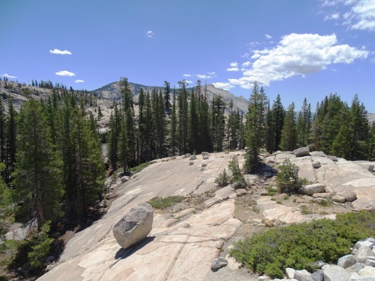
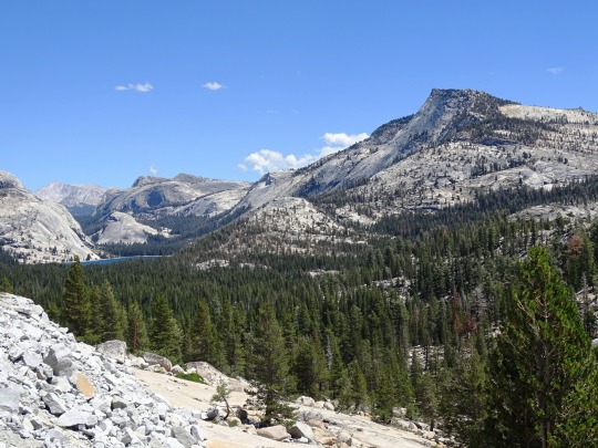
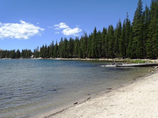

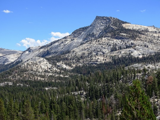
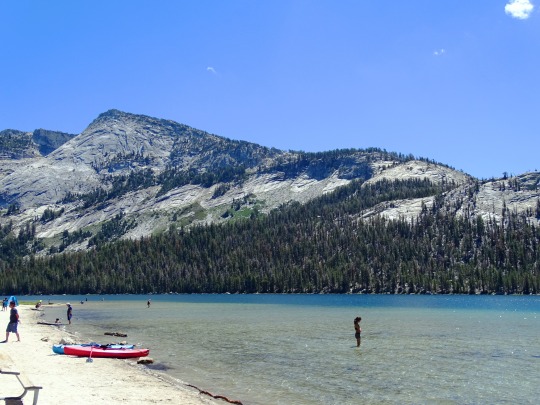
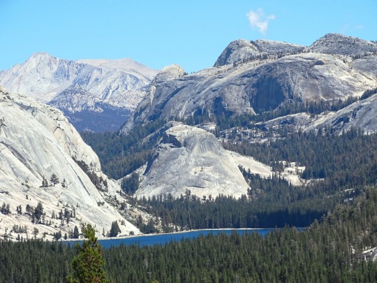
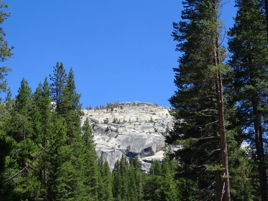
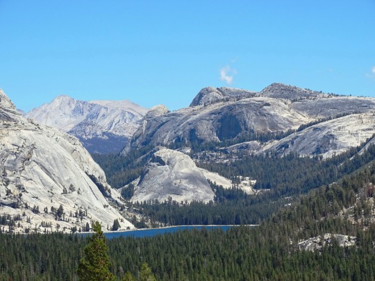
Yosemite National Park, CA (No. 7)
Tenaya Lake is an alpine lake in Yosemite National Park, located between Yosemite Valley and Tuolumne Meadows. The surface of Tenaya Lake has an elevation of 8,150 feet (2,484 m). The lake basin was formed by glacial action, which left a backdrop of light granite rocks, whose beauty was known to the Native Americans. Today, Tenaya Lake is easily accessible by State Route 120 and is a popular lake for water activities.
Tenaya Lake is named after Chief Tenaya, who was the chief of the native people who lived in Yosemite Valley before being driven out by the Mariposa Battalion. Tenaya protested that the lake already had a name: Pie-we-ack, or "Lake of the Shining Rocks." This original name is now attached to Pywiack Dome, a granite dome to the east of the lake.
As part of the 1864 Yosemite grant, the area became the first park land to be federally protected for preservation and public use. Yosemite became a national park in 1916 with the advent of the National Park Service.
In 1868, John Muir wrote about the Tenaya Lake's beauty and timelessness in My First Summer in the Sierra.
Tenaya Lake was created by the Tenaya Glacier, which flowed out of the vast Tuolumne Ice Sheet and down to Yosemite Valley. This same glacier created Half Dome. The Tenaya Glacier was lightly loaded with debris, and did not leave a large amount of moraine material near Tenaya Lake.
The lake is supplied by a network of creeks and springs including Murphy Creek to the northwest and Tenaya Creek. Tenaya Creek is an outflow of Cathedral Lakes and serves as both the principal inlet and outlet of Tenaya Lake. Tenaya Creek also runs through Tenaya Canyon into Yosemite Valley.
Source: Wikipedia
#Yosemite National Park#Sierra Nevada#Mono County#geology#flora#California#summer 2022#tourist attraction#landmark#landscape#countryside#USA#nature#forest#woods#fir#pine#rocks#travel#original photography#vacation#creek#granite#Tenaya Lake#lake shore#blue sky#clou#alpine lake#canoe#beach
14 notes
·
View notes
Text


Ülkemiz yemyeşil ormanlara, muhteşem sahillere, benzersiz doğal oluşumlara ev sahipliği yapıyor. Bununla birlikte Türkiye'de son derece nadir hatta eşi benzeri olmayan doğal yapılar da var. Her ne kadar fazla bilinmese de onlardan en ünlü ve en şaşırtıcı olanı Konya il sınırları içerisinde yer alan Karapınar Çölü.
🔸Karapınar Çölü, şehir merkezine yaklaşık 100 kilometre uzaklıktaki Karapınar ilçesinde bulunuyor. Konya Havzası’ndaki en kurak yerlerden biri olan Karapınar aynı zamanda ülkemizin en az yağış alan noktası konumunda. Türkiye’nin tek çölü ünvanına sahip olan Karapınar, yüzyıllar süren volkanik faaliyetlerin bulunduğu bir coğrafya üzerinde yer alıyor.
🔸Karapınar Çölü’nü oluşturan temel şey, uzun zaman önce bölgede yer alan buzul gölleri. Eski bir göl tabanı olan Karapınar bölgesindeki topraklar, yıllar süren kuraklık ve rüzgar erozyonu nedeniyle çöl haline gelmiş durumda. Çölleşmeden yaklaşık 103 bin hektarlık bir alan etkileniyor.
🔸Karapınar aynı zamanda rüzgâr erozyonuna karşı etkin bir mücadelenin yürütüldüğü bir alan. 1950’lı yılların sonunda, Karapınar’ın çölleşmesini önlemek adına rüzgâr erozyonuna karşı başlatılan mücadele, bugün çölde yeşil arazilerin ve kullanılabilir tarım alanlarının ortaya çıkmasına katkı sağladı. Öyle ki Karapınar yeryüzündeki en yeşil çöllerden biri olarak kabul ediliyor
Kaynak: Instagram/@listelist
.......
Türkiye 🇹🇷
Our country is home to lush forests, magnificent beaches and unique natural formations. However, there are also extremely rare and even unique natural structures in Turkey. Although it is not well known, the most famous and surprising one is the Karapınar Desert, located within the borders of Konya province.
🔸Karapınar Desert is located in Karapınar district, approximately 100 kilometers away from the city center. Karapınar, one of the driest places in the Konya Basin, is also the point with the least rainfall in our country. Karapınar, which has the title of Turkey's only desert, is located on a geography where volcanic activities lasted for centuries.
🔸The main thing that makes up the Karapınar Desert is the glacial lakes that were in the region a long time ago. The lands in the Karapınar region, an ancient lake bottom, have become desert due to years of drought and wind erosion. An area of approximately 103 thousand hectares is affected by desertification.
🔸Karapınar is also an area where an effective fight against wind erosion is carried out. The fight against wind erosion launched at the end of the 1950s in order to prevent the desertification of Karapınar contributed to the emergence of green lands and usable agricultural areas in the desert today. So much so that Karapınar is considered one of the greenest deserts on earth.
Kaynak: Instagram/@listelist
#desert#çöl#Karapınar çölü#konya#türkiye#doğa#travel photography#travel destinations#travel#manzara#view#natural#europe#africa
30 notes
·
View notes
Text
Whumpuary Day 7
Deep Breaths
manhandling | tied up | tears
Prev. || Masterlist
Cw: torture, drowning, self sacrifice for a cause, thoughts of death, restraints, noose, choking, slight asphyxiation, kinda stress position, manhandling
Cold water soaked through the neck of Whumpee’s dirty shirt, leaking down towards their torso in icy beads. They kept their jaw clenched, teeth grinding against each other to stop them from chattering. They were certain that there had once been ice in the basin, perhaps melted only moments before. No water straight from the tap came out feeling straight glacial.
Their lungs burned, but not as badly as they had anticipated, more so a warm ache than the fiery flicker of water invading their chest. Their hands were shaking, braced against the edge of the sink, fingertips just submerged in the water.
Breathe. In and out, slow, calm breaths. They suppressed the urge to open their mouth, to greedily gulp the air that seemed like such a luxury in these short moments. They knew that’s what Whumper was waiting for, however. For them to release their last possible defense, shove their head back under the depths mid-breath so their desperate claim for oxygen was filled with with water, and Whumpee knew once those first droplets made their way through their lungs, filling them, it was all over. Once that happened, the torture would only become more vigorous. Less time between each submerge, left to choke on the freezing liquid while thrashing below the surface. A merciless cycle that would only cease once they either spilled all their secrets between watery coughs or were fortunate enough to surrender consciousness, heart eventually drawn to stop between the lack of oxygen and impending hypothermia. They doubted Whumper would let that be their finale, though, they’d be resurrected and their torment would only continue, though perhaps they’d be given a bit to recover, a few days to recuperate from the physical trauma before being subject once more to the tortures. They doubted that.
Whumper had stopped asking them questions. They didn’t mind that much, they supposed the repetition of the single phrase had gotten annoying even to Whumper’s own ears. It certainly had theirs. The insistent droning, “who do you work for?” or “what do you know?” or “just tell me, Whumpee, and this can all be over,” it had gotten extremely pestering rather quickly. They supposed that could be a form of torture on its own, having to listen to Whumper’s voice repeat the same meaningless words. When would the message finally pierce through their thick skull? Whumpee wasn’t going to break. Sure, they could bend and strain and physically shatter on every possible level, but they weren’t going to break.
Halfway through their slow inhale, Whumper shoved their head down again and Whumpee quickly held their breath, cutting off the air just as their face was submerged under the water. The cold bit at their skin like needles, their fingertips digging against the metal as they fought the urge to thrash. Fighting would only exhaust them, and exhaustion would do them no good.
On and on it went. Tortured minutes dragged into hours, or so it felt. Whumper wasn’t giving them time to even think of responding anymore, barely enough to drag in a ragged breath before they were forcefully exposed to the water, which only seemed to grow colder as their lips turned a light hue of purple. It was going fine, though, well at least as fine as torture could possibly go. They hadn’t slipped, even as a heavy exhaustion began to tug at their muscles and mind, tempting them to open their mouth and let the confessions come spilling out. Of course, they pushed that thought away, burying it deep behind the layers of resentment in their mind. They weren’t going to let Whumper win this. Especially not with only a bit of water.
They kept their eyes firmly shut as their head was thrust back under the water once more, the cold stinging against their already numb cheeks. They could feel the water dripping down their back, soaking their socks, shivering with each drop. Their lungs constricted and cramped, chest now burning. They had barely been given a chance to exhale their last breath, and had only been able to take in a portion of oxygen typically needed to produce a full inhale. Their toes were already curling inside their soaked shoes, scuffing against the ground as they began to twist, jolting against their own will.
When the punch came, they had nothing left to steel themself with. Their last breath came out in a cough, a stream of bubbles breaking the surface as they gasped. Water invaded their mouth, their nose, filling their throat in a matter of seconds. They were choking, drowning, all beneath Whumper’s hand. They couldn’t think anymore. All logic, reason, gone. Couldn’t think, couldn’t breathe. Fuck.
They twisted, kicking their legs with a desperate attempt to hook Whumper’s knee, perhaps send them toppling and in turn, freeing themself. Their efforts were futile, struggles pathetic at the very best. It was a loosing battle, Whumper only shoved their head further towards the bottom of the basin. A second hand pressed against the back of their neck, nails digging in as it held them tightly under the water. Water burned their eyes as they opened, but that was the least of Whumpee’s concerns as the coherency of their thoughts quickly diminished.
Then they started to tire. Not the same sort of exhaustion they had been fighting off for the past day. This was heavy, dragging them down like a boulder tethered to their core. They could feel the energy seeping from them, for each droplet that fell from their soaking figure with it came a fraction of their consciousness. It was moving so fast, and they were moving so slow. A chain looped around their throat, forcing their head further down into the sink’s depths, past the stopped drain and even further below.
They’d always imagined drowning would take longer. Hours and seconds all felt the same below the surface. They tried to hold on, but the threads were slipping through their fingers, pulling away faster than they could grab them back, with it slowly unraveling their consciousness until the last fabric of reality was snatched away to the cold water.
•••
Whumpee didn’t believe they were left out for long, because when the first slivers of consciousness began to return to their mind, the first coherent feelings they became aware of was the awful burning. It felt like their chest was on fire, blood turned to boil in their veins. Water spilled from their lips, dripped from their nose, awful bouts of coughing rattling them to the core. Their head spun with disorientation, vision so blurred their eyes might as well have been closed.
“Come on, that’s it. Just breathe.”
The words were barely heard over the water stuck in Whumpee’s ears, but the gentleness of the tone took them by shock. In the passing moments, their awareness continued to expand, until they were somewhat sensible of the situation around them. They were standing, barely, pressed between Whumper and the basin to keep them upright. Their former boss’s arm wrapped around their chest, their other hand resting against Whumpee’s back, fingers digging in with a manner a bit too abrasive to be tender.
“Welcome back,” Whumper smirked, though their face was still distorted through Whumpee’s eyes, their amusement was beyond clear through their voice. “Is there anything you’d like to say?”
Their first attempt at words came out nothing but a broken wheeze as Whumpee clumsily tried to push away, but Whumper didn’t let them fall. Whumpee coughed, a final dribble of watered down saliva slipping past their lips, tinted pink with the bloody taste that still coated their mouth and throat, before they made a second attempt at speaking.
“Nn’thin to you,” Their voice sounded pitiful, like broken glass that had yet to fully shatter, teetering precariously in the window frame just waiting for the gust that would send the entire structure crashing in.
They weren’t sure what they were hoping to prove with that sentence. Were they trying to demonstrate a shred of defiance, to show Whumper that even then the power they held was only from their own point of view? Or were they trying to anger them only? Regardless, their words seemed to draw only a humorous response as Whumpee chuckled.
“I suppose that means you’re feeling well enough to continue.”
By this point, Whumpee’s heart seemed to have sunken so deep into their chest it would be impossible to go any further, but that was clearly proved wrong. A cold worse than the ice water creeped up their chest, stomach twisted into painful knots as Whumper stood them up straight. The room spun around them, edges of their vision going static as they were half led, half dragged across a small part the room, their feet nothing but deadweight beneath them as they didn’t even make an attempt to stumble along.
“Better perk up quick, Whumpee,” Whumper’s voice pulled with a smirk, giving them a light push into the guard’s waiting form, who grabbed their wrists and wrestled their arms behind their back before Whumpee could so much as stumble properly. They felt the cruel bite of metal against their wrists, as Whumper reached to grab something hanging from the ceiling, slipping it around Whumpee’s neck and fastening it tight. They let out a strangled gasp as they felt the coarse fibers of rope press against their throat, their breath only being cut as Whumper then stepped back to adjust the other end of the noose, looped through a ring in the ceiling and tied to a post against the nearest wall, pulling it to a point where Whumpee could just barely stay upright on the balls of their feet.
“I can’t say this will end well for you otherwise.”
——————————
Next
Tag list: @pickleking8 @blood-enthusiast @t0rture-me @sparrowsage @enigmawritesstuff
#whump#whumpblr#whump community#its me coal#whump writing#coal wrote something#whumpuary day 7#whumpuary#whumpuary series#whumpee#whumper#whump prompt#creepy whumper#captured whumpee#whump prompts#captivity whump#intimate whumper#writing prompt#whump drabble#kidnapped whumpee#abused whumpee#tw torture#torture#spy whump
61 notes
·
View notes
Text
Southern Ocean
In 2000, the Southern Ocean is the newest ocean recognized by the International Hydrographic Organization.
It borders Antarctica in its entirety.
In terms of size, it’s the fourth-largest at 20,327,000 square kilometers. It extends out to 60 degrees South latitude.
It’s an extreme environment and is the least understood of the 5 oceans. This is because it is unexplored, far from populated areas, and has a severe climate. Despite the Southern Ocean being unexplored, about 80% of all oceans in the world are unexplored. There’s still a lot of work to do for ocean exploration.
Includes: Amundsen Sea, Bellingshausen Sea, part of the Drake Passage, Ross Sea, a small part of the Scotia Sea, Weddell Sea, and other tributary water bodies
Area
Total Area: 21.96 million sq km
Area - Comparative: Slightly more than twice the size of the US
Coastline: 17,968 km
Climate: Sea temperatures vary from about 10 degrees Celsius to -2 degrees Celsius; cyclonic storms travel eastward around the continent and frequently are intense because of the temperature contrast between ice and open ocean; the ocean area from about latitude 40 south to the Antarctic Circle has the strongest average winds found anywhere on Earth; in winter the ocean freezes outward to 65 degrees south latitude in the Pacific sector and 55 degrees south latitude in the Atlantic sector, lowering surface temperatures well below 0 degrees Celsius; at some coastal points intense persistent drainage winds from the interior keep the shoreline ice-free throughout the winter
Ocean Volume: 71.8 million cu km
Percent of World Ocean Total Volume: 5.4%
--------------------------------------------------------------------------
Bathymetry
Continental Shelf: A rather flat area of the sea floor adjacent to the coast that gradually slopes down from the shore to water depths of about 200 m (660 ft). Dimensions can vary: they may be narrow or nearly nonexistent in some places or extend for hundreds of miles in others. The waters along the continental shelf are usually productive in both plant and animal life, both from sunlight and nutrients from ocean upwelling and terrestrial runoff. Compared to the continental shelf found in other oceans, in Antarctica the continental shelf is narrower and much deeper. In addition, the continental shelf has been deeply scoured by glacial action.
Astrid Ridge
Belgrano Bank
Gunnerus Ridge
Hayes Bank
Iselin Bank
Continental Slope: Where the ocean bottom drops off more rapidly until it meets the deep-sea floor (abyssal plain) at about 3,200 m (10,500 ft) water depth. The deep waters of the continental slope are characterized by cold temperatures, low light conditions, and very high pressures. Sunlight does not penetrate to these depths, having been absorbed or reflected in the water above. The continental slope can be indented by submarine canyons, often associated with the outflow of major rivers. In the case of Antarctica, the continental slope has been scoured by glacial action cutting troughs and canyons down the slope. Another feature of the continental slope are alluvial fans or cones of sediments carried downstream to the ocean by major rivers and deposited down the slope.
Southern Ocean
Amery Basin
Filchner Trough
Hillary Canyon
Pobeda Canyon
Abyssal Plains: At depths of over 3,000 m (10,000 ft) and covering 70% of the ocean floor, are the largest habitat on earth. Sunlight does not penetrate to the sea floor, making these deep, dark ecosystems less productive than those along the continental shelf. Despite their name, these “plains” are not uniformly flat; they are interrupted by features like hills, valleys, and seamounts.
Amundsen (Abyssal) Plain
Enderby (Abyssal) Plain
South Indian/Australian-Antarctic Basin
Southeast Pacific/Bellinghausen Basin
Weddell (Abyssal) Plain
Mid-Ocean Ridge: Rising up from the abyssal plain, is an underwater mountain range, over 64,000 km (40,000 mi) long, rising to an average depth of 2,400 m (8,000 ft). Mid-ocean ridges form at divergent plate boundaries where two tectonic plates are moving apart and new crust is created by magma pushing up from the mantle. Tracing their way around the global ocean, this system of underwater volcanoes forms the longest mountain range on Earth. Fracture Zones are linear transform faults that develop perpendicular to the line of the mid-ocean ridge which can offset the ridge line and divide it into segments.
Pacific-Antarctic Ridge
Undersea Terrain Features: The Abyssal Plain is commonly interrupted by a variety of commonly named undersea terrain features including seamounts, guyots, ridges, and plateaus. Seamounts are submarine mountains at least 1,000 m (3,300 ft) high formed from individual volcanoes on the ocean floor. They are distinct from the plate-boundary volcanic system of the mid-ocean ridges, because seamounts tend to be circular or conical. A circular collapse caldera is often centered at the summit, evidence of a magma chamber within the volcano. Flat topped seamounts are known as guyots. Long chains of seamounts are often fed by "hot spots" in the deep mantle. These hot spots are associated with stationary plumes of molten rock rising from deep within the Earth's mantle. These hot spot plumes melt through the overlying tectonic plate as it moves and supplies magma to the active volcanic island at the end of the chain of volcanic islands and seamounts. An undersea ridge is an elongated elevation of varying complexity and size, generally having steep sides. An undersea plateau is a large, relatively flat elevation that is higher than the surrounding relief with one or more relatively steep sides. Although submerged, these features can reach close to sea level.
Akopov Seamounts
De Gerlache Seamounts
Endurance Ridge
Marie Byrd Seamount
Maud Rise
Scott Seamounts
Ocean Trenches: The deepest parts of the ocean floor and are created by the process of subduction. Trenches form along convergent boundaries where tectonic plates are moving toward each other, and one plate sinks (is subducted) under another. The location where the sinking of a plate occurs is called a subduction zone. Subduction can occur when oceanic crust collides with and sinks under (subducts) continental crust resulting in volcanic, seismic, and mountain-building processes. Subduction can also occur in the convergence of two oceanic plates where one will sink under the other and in the process create a deep ocean trench. Subduction processes in oceanic-oceanic plate convergence also result in the formation of volcanoes. Over millions of years, the erupted lava and volcanic debris pile up on the ocean floor until a submarine volcano rises above sea level to form a volcanic island. Such volcanoes are typically strung out in chains called island arcs. As the name implies, volcanic island arcs, which closely parallel the trenches, are generally curved.
South Sandwich Trench; the deepest location in the Southern Ocean
Atolls: Due to the extremely cold water there are no atolls in the Southern Ocean
--------------------------------------------------------------------------
Highest Point: Sea Level
Lowest Point: Southern end of the South Sandwich Trench -7,434 m unnamed deep
Mean Depth: -3,270 m
Ocean Zones: Composed of water and in a fluid state, the ocean is delimited differently than the solid continents. The ocean is divided into three zones based on depth and light level. Although some sea creatures depend on light to live, others can do without it. Sunlight entering the water may travel about 1,000 m into the oceans under the right conditions, but there is rarely any significant light beyond 200 m.
The upper 200 m (656 ft) of the ocean is called the euphotic, or "sunlight," zone. This zone contains the vast majority of commercial fisheries and is home to many protected marine mammals and sea turtles. Only a small amount of light penetrates beyond this depth.
The zone between 200 m (656 ft) and 1,000 m (3,280 ft) is usually referred to as the "twilight" zone, but is officially the dysphotic zone. In this zone, the intensity of light rapidly dissipates as depth increases. Such a minuscule amount of light penetrates beyond a depth of 200 m that photosynthesis is no longer possible.
The aphotic, or "midnight," zone exists in depths below 1,000 m (3,280 ft). Sunlight does not penetrate to these depths and the zone is bathed in darkness.
--------------------------------------------------------------------------
Natural Resources: Probable large oil and gas fields on the continental margin; manganese nodules, possible placer deposits, sand and gravel, fresh water as icebergs; squid, whales, and seals - none exploited; krill, fish
Natural Hazards: Huge icebergs with drafts up to several hundred meters; smaller bergs and iceberg fragments; sea ice (generally 0.5 to 1 m thick) with sometimes dynamic short-term variations and with large annual and interannual variations; deep continental shelf floored by glacial deposits varying widely over short distances; high winds and large waves much of the year; ship icing, especially May-October; most of region is remote from sources of search and rescue
Geography - Note: The major chokepoint is the Drake Passage between South America and Antarctica; the Polar Front (Antarctic Convergence) is the best natural definition of the northern extent of the Southern Ocean; it is a distinct region at the middle of the Antarctic Circumpolar Current that separates the cold polar surface waters to the south from the warmer waters to the north; the Front and the Current extend entirely around Antarctica, reaching south of 60 degrees south near New Zealand and near 48 degrees south in the far South Atlantic coinciding with the path of the maximum westerly winds
--------------------------------------------------------------------------
Enviornment
Enviornment - Current Issues: Changes to the ocean's physical, chemical, and biological systems have taken place because of climate change, ocean acidification, and commercial exploitation
Enviornment - International Agreements: The Southern Ocean is subject to all international agreements regarding the world's oceans; in addition, it is subject to these agreements specific to the Antarctic region: International Whaling Commission (prohibits commercial whaling south of 40 degrees south [south of 60 degrees south between 50 degrees and 130 degrees west]); Convention on the Conservation of Antarctic Seals (limits sealing); Convention on the Conservation of Antarctic Marine Living Resources (regulates fishing) note: mineral exploitation except for scientific research is banned by the Environmental Protocol to the Antarctic Treaty; additionally, many nations (including the US) prohibit mineral resource exploration and exploitation south of the fluctuating Polar Front (Antarctic Convergence), which is in the middle of the Antarctic Circumpolar Current and serves as the dividing line between the cold polar surface waters to the south and the warmer waters to the north
Climate: Sea temperatures vary from about 10 degrees Celsius to -2 degrees Celsius; cyclonic storms travel eastward around the continent and frequently are intense because of the temperature contrast between ice and open ocean; the ocean area from about latitude 40 south to the Antarctic Circle has the strongest average winds found anywhere on Earth; in winter the ocean freezes outward to 65 degrees south latitude in the Pacific sector and 55 degrees south latitude in the Atlantic sector, lowering surface temperatures well below 0 degrees Celsius; at some coastal points intense persistent drainage winds from the interior keep the shoreline ice-free throughout the winter
--------------------------------------------------------------------------
Ports and Terminals
Major Seaport(s): McMurdo, Palmer, and offshore anchorages in Antarctica
Note: Few ports or harbors exist on the southern side of the Southern Ocean; ice conditions limit use of most to short periods in midsummer; even then some cannot be entered without icebreaker escort; most Antarctic ports are operated by government research stations and, except in an emergency, are not open to commercial or private vessels
5 notes
·
View notes
Photo
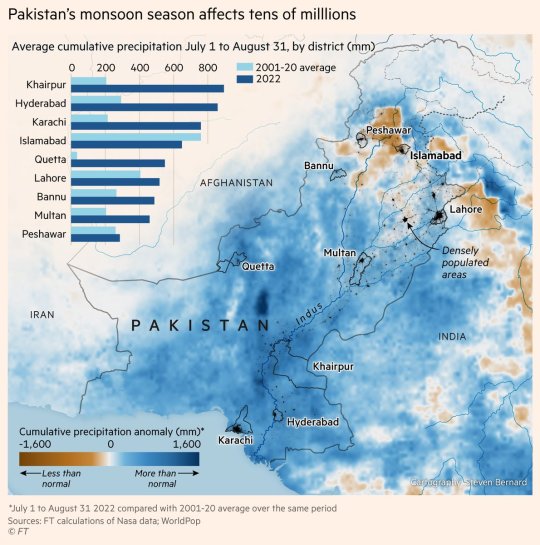
Map showing rainfall anomalies in Pakistan, where a third of the country is flooded. Parts of the country have experienced 1.5 metres more rain than normal since July.
by @sdbernard
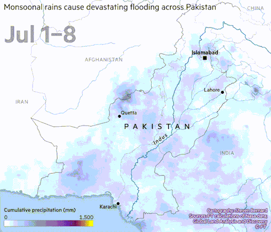
Rainfall anomalies here we show the cumulative rainfall since July 1 overlaying it with the croplands in the region. 3.6 million acres have been affected in Pakistan alone.

Location of the glaciers in the Hindu Kush Himalaya region. Glacial melt has added to the effects of more aggressive monsoons, by releasing snow and ice melt into Pakistan’s river basins.
110 notes
·
View notes
Photo
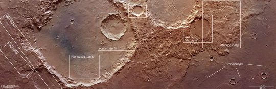
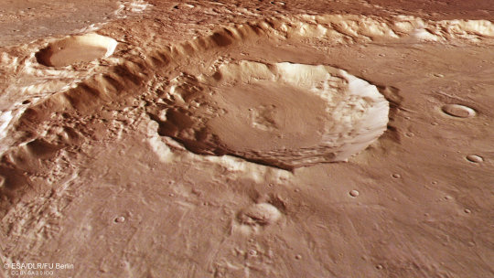
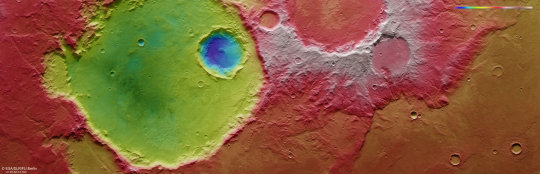

Craters and cracks on Mars' Terra Sirenum region This complex region of craters and fractures in the Terra Sirenum region highlights the varied history of Mars. The image above was taken by ESA's Mars Express on 5 April 2022. The image, taken by the High Resolution Stereo Camera (HRSC), is dominated by a large impact crater on the left (south) of the image, which measures about 70 km wide. This crater is in the Terra Sirenum region of Mars, which lies in the southern hemisphere. Another area of the same region was imaged by Mars Express in 2017. The imprint of Martian wind is detectable within the crater—in the lower, eastern part of the crater, rough features known as yardangs are visible signatures of wind erosion. The contrasting dark-toned sand within the crater may have been transported into the flat base by wind. Clues left by water Nestled within the large crater is a smaller crater measuring about 20 km wide. The smaller crater and its neighbor can be seen in staggering detail in the perspective view. The structure and outline of the crater, and its smaller neighbor in the background of the perspective image, suggest that water or ice may have covered this surface when the impact occurred. Signatures of past glaciers are visible in the smooth surface of the two neighboring craters in the perspective image. The glaciers are thought to be made from a mixture of debris and ice, which flow downhill. The sedimented debris leaves clues about the direction and movement of the ice through the small sweeping channels in the base of the craters. Water also leaves its mark in other parts of the scene. The winding valley on the far left of the main color image measures up to 1.8 km in width. It is thought to have been a pathway for water which melted in the basin to the east. The right (north) side of the image showcases a complex region of twisting valleys, known as dendritic valleys, whose origins are believed to be due to rain or snow early in Martian history. Tectonic stress The surface of the Red Planet is marked by the dynamic movements of the martian crust. Parallel to the large valley at lower left in the main color image, and about 10 km away, lies a fracture which cuts through the basin. When the crust is pulled apart by tectonic stress, parts of the surface drop downward creating the faults. These "graben" can also be found in a region called Icaria Fossae, marked on the context map. Lava also makes its mark on the surface in two sections of the image of the region. While the larger crater has glacial signatures, the impact crater in the north shows signs of a layer of lava on the crater floor (labeled as the "lava filled crater" in the top image). Small slivers, called wrinkle ridges, are marked in the lower right corner of the image. These are formed when a soft lava sheet is compressed by tectonic forces, causing a ridge where the material buckles over the lava sheet. The array of features visible in one image shines a light on the varied physical processes and history of the Red Planet.
62 notes
·
View notes
Text
Reyal At A Glance - Intro
Map by @nexelart (twit)
Welcome to Reyal, the second planet from Tenav!
Reyal is a planet much like our own Earth, in that it supports a wide array of life and boasts a large hydrosphere. On top of that, it's only 1.27x larger than Earth, and has an atmospheric composition fairly similar to our own, with Reyal having 26.71% oxygen content as compared to Earth's 20.95%.
There, however, is where the similarities end.
Reyal has an orbital period of only 3.27 months, as Tenav is only a K7V class star. As such, Reyal doesn't really experience any seasons as we do here on Earth. Any changes are barely noticeable as it speeds around Tenav, causing only minor temperature differences during their year.
On top of that, Reyal experiences much heavier tidal activity, as it has two decently sized moons, Ro and Velgae. In conjunction with Tenav, volcanism and ocean/lake tides tend to be a bit more on the extreme side of things when compared to Earth.
Life emerged on Reyal some 4.7bn years ago, only a few hundred million years after the formation of Ro. Life on Reyal has never had it easy; from asteroids, comets, heavy glacial and hothouse periods, life on Reyal has seen the edge of oblivion numerous time.
Despite all this, life has found a way, and has thrived and even flourished through the ages. No example is better than Reyal's own sapient race, the Lyratet.
In this series of posts, I will be covering some key areas on Reyal, and going over their history and importance to the Lyratet; I hope you enjoy!
Directory: Intro | Climate | the Land of Tenav's Dawn | the Desert Rings | Therikine | the Great Central Desert Mountains | the North Glacial Plains | the Yuniv-Semat Basin | Juleg Marrdev Technocracy | Yuniv-Semat Trail | Ro | Velgae
#my posts#maps#Reyal#worldbuilding#reyal at a glance#creative writing#sophonts#aliens#writeblr#as we go along#awga
23 notes
·
View notes
Text
Poppycock And Bunkum: Here Are 19 Myths That Cincinnati Refuses To Give Up
Cincinnati loves a good story, and we certainly have some doozies. Some of our favorite stories about our favorite town are actually true. Some of our dearest and most treasured stories, however, persist despite a complete lack of evidence and not an iota of proof. Among them:
Cincinnati is located upon seven hills.
To be geologically technical, Cincinnati has no hills at all, only valleys. The central basin in which our downtown is located is surrounded by what geologists call an eroded peneplain. In other words, our town occupies a glacially scoured, level plain into which streams have cut a network of valleys. What we count as “hills” are just tongues of this surrounding plain extending into the central valley – and once we start counting those, there’s no stopping. One recent survey has identified at least 80 named Cincinnati “hills.”
A woman named Ida Martin, who lived in a hollow sycamore tree and did laundry for the soldiers at Fort Washington, gave her name to Mount Ida, later renamed Mount Adams.
It is authentically reported, by an eyewitness, that a woman who did laundry for the soldiers at Fort Washington lived in a hollow sycamore tree on the slopes of what later became Mount Adams. However, that source does not give her name. There was a domestic servant named Ida Martin who lived on what later became Mount Adams, but this was long after Fort Washington had been demolished, this woman was not a laundress and she lived in a cabin, not a hollow tree. Mount Adams was previously known as Mount Ida, but that nickname was a reference to classical mythology, not to any woman who lived in the area. Somewhere along the line, these three separate facts got conflated into a treasured Cincinnati fable.
Arnold’s Bar opened on Eighth Street in 1861 and three generations of Simon Arnold’s family lived upstairs for 98 years (brewing gin in a bathtub).
According to the Cincinnati City Directory, Simon Arnold indeed occupied part of a building on the north side of Eighth Street, just east of Main in 1861. However, he was not running a saloon. He was building billiard tables, because he was a carpenter until 1877. From 1856 to 1877, there was a saloon on the north side of Eighth Street, just east of Main, but it was run by George and Wilhelmina Weber, not anyone named Arnold. The Arnold family did not take over that saloon until 1877, when Wilhelmina Weber retired. From 1922 until 1933, no bar, saloon, speakeasy or restaurant operated out of that address at all. No one from the Arnold family lived in that building from 1926 until 1933. The story of Arnold’s founding date and continuous occupancy appears to have been embellished by Elmer Arnold in 1959 when he sold the venerable establishment to Ernst Wiedemann.
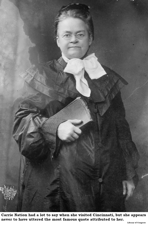
Carrie Nation, on a visit to Cincinnati, declined to smash any of the notorious Vine Street saloons, claiming, “I would have dropped from exhaustion before I had gone a single block.”
Carrie Nation did, in fact, visit the Queen City at least twice. During her visits, she did not demolish a single saloon. She also gave numerous interviews while she was in town. In none of those interviews did she claim exhaustion prevented her from attacking Cincinnati saloons. Rather, she pointedly explained that she arrived here under a court-imposed performance bond she would forfeit if she demolished anything. The famous quote does not appear in print until 20 years after her Cincinnati visits.
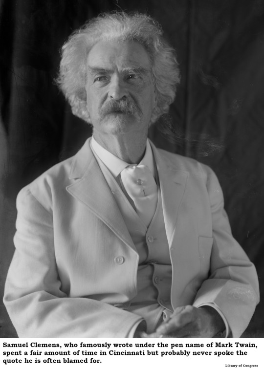
Mark Twain said, “When the end of the world comes, I want to be in Cincinnati because it's always 10 years behind the times.”
Everyone quotes Mr. Samuel Clemens and his eschatological analysis of the Queen City, but no one has ever provided a decent citation for it. The quote appears in none of his voluminous writings. To confuse matters, multiple scholars have found similar quotes attributed to quite a few famous folks about quite a few other cities. To further confuse matters, the quote sometimes appears as one sentence and sometimes as two sentences and the lag, while usually 10 years, is sometimes 20 years. In brief, if Mark Twain ever uttered such a comment, no one appears to have recorded it.
The Cincinnati subway failed because of poor design and cost overruns.
In his exhaustive review of “Cincinnati’s Incomplete Subway” (2010), Jacob R. Mecklenborg notes that, despite the usual financial shenanigans of the Boss Cox political machine, Cincinnati’s Rapid Transit Loop project (which we know as the subway) was actually pretty well thought-out and potentially quite viable. Mecklenborg concludes that the newly elected Progressive city administration of 1925 could have saved the project but declined to do so to avoid giving the remaining Cox minions a victory. Most of the alleged shortcomings of the subway were actually unfounded Progressive propaganda from the 1920s.
Charles Manson attended Walnut Hills High School and/or used to hang out in Mount Adams.
After his arrest and conviction in California, Cincinnatians suddenly began remembering Charles Manson’s early days in Cincinnati. Or, shall we say, misremembering? All the documentation – and Manson’s life has been inspected to the subatomic level – affirm that young Charles was shipped out of Cincinnati by age five, never to return. While it’s not impossible that he drifted through town from time to time, his high school years were spent in various reform schools. The period in which he allegedly hung out, swilling tequila in Mount Adams, find him involved in West Coast scams or serving time in California prisons. We can’t deny he was born here, but there’s no evidence Manson returned after an unhappy infancy.
Cincinnati Chili gets its distinctive flavor from chocolate.
A great many Cincinnatians inaccurately yet vehemently insist that the secret ingredient to Cincinnati Chili is chocolate. Most “authentic” Cincinnati Chili recipes in print or online make this claim. The myth may be traced to Marion Rombauer Becker, who took over compiling the “Joy of Cooking” on the death of her mother, Irma Rombauer. Marion’s “Cincinnati Chili Cockaigne” recipe (the “Cockaigne” label signaled that the Rombauers served that dish at their home in Cincinnati) was the first to claim a dubious role for chocolate. As Cincinnati Chili maven Dann Woellert has repeatedly noted, the families who actually cooked and served our favorite dish deny there’s any chocolate involved.
Thomas Edison read every book in the old Ohio Mechanics Institute library.
Young Tommy Edison spent a fruitful year in Cincinnati as a telegraph operator and he even did some tech support for the early Procter & Gamble. For a young inventor, the most useful resource in Cincinnati would have been the library of the Ohio Mechanics Institute, with 10,000 volumes on science and technology. However, to read every book, Edison would have had to consume 27 volumes a day and master a dozen languages. Edison sent an autographed photo to the Institute in later years, thanking them for allowing him to use the library and maybe that’s where the rumor started.

The first bathtub in the United States was installed in Cincinnati
A satirical essay by H. L. Mencken, titled "A Neglected Anniversary," was published 28 December 1917, in the New York Evening Mail. Mencken claimed that the first bathtub in the United States was installed in a Cincinnati home by one Adam Thompson in 1842. Although this was totally “fake news,” it was repeated as truth many times over the next century and still pops up as “fact” online today.
Superman is buried in Spring Grove Cemetery
The earthly remains of George Reeves, the actor who played Superman on television during the 1950s, were held in a vault at Spring Grove Cemetery for a couple of months in 1959 while his mother sorted out a permanent resting place. Although she wanted a mausoleum in Cincinnati, it proved impracticable. Reeves’ body was eventually cremated here and the ashes shipped to California, where they remain today.
UC’s Crosley Tower entombed an unfortunate worker during construction.
Crosley Tower at the University of Cincinnati is a monument to brutalist architecture and is now scheduled for demolition. It was originally poured in 1969 as a single piece of concrete. Rumor has it that a workman fell in as the slurry was being pumped, and because the pour could not be interrupted without extravagant cost, he remains entombed there. Construction of this building was heavily documented and no one fell in. Rumors that workers dropped a Volkswagen into the mix while pouring are also false.
There’s a village of evil midgets out by Mount Rumpke.
Although the rumor was disproved years before the alleged “Munchkinville” was demolished, there are still people who swear a “Tiny Town” of malicious little people exists out in Colerain Township. All the rumors trace back to the Handle Bar Ranch, originally a bicycle rental station later devoted to horse-drawn hayrides, owned by the late Percy and Anna Ritter. Mr. Ritter’s idiosyncratic architecture and Mrs. Ritter’s unusual décor inspired generations of high school students to mount midnight forays looking for munchkins. The alleged Tiny Town has been consumed by the expansion of the Rumpke waste disposal operation.
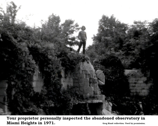
There is an exploded crematorium once used for Satanic rituals in Miami Heights.
There is most definitely something out in the woods near Buffalo Ridge Road in Miami Heights, but it has nothing to do with Satan. After Cincinnati’s “fireproof” Chamber of Commerce building burned in 1911, the massive granite masonry was acquired by the Cincinnati Astronomical Society who hoped to build a world-class observatory overlooking Miamitown. Costs rose astronomically (ahem!) and then the Great Depression landed so the observatory got not much further than a foundation, a few walls and piles of randomly delivered used granite. It looked like a building had exploded out in the woods, hence the rumors. Some of the stones were salvaged to build a Stonehenge-like monument to architect H.H. Richardson in Burnet Woods. The rest have been swallowed by a county park.
Hordes of fanatics draped in “resurrection robes” climbed Cincinnati’s Brighton Hill, awaiting the end of the world in 1843 or 1844.
Cincinnati was, indeed, a hotbed of Millerism in 1843. The Millerites, followers of New York preacher William Miller, did believe the world would end in 1843 or 1844. There are newspaper accounts of Millerites quitting their jobs and giving away all of their possessions and being very disappointed when the world did not end according to William Miller’s calculations. However, the scene of white-clad cultists perched on any of the local hills appears to be only rumor.
A Cincinnati doctor used to prescribe ketchup as medicine.
While not entirely true, this legend is not entirely false, either. During the 1830s, a self-licensed Cincinnati “doctor” named Archibald Miles marketed a concoction he called “Miles’ Compound Extract of Tomato, the Genuine Tomato Pill,” derived from the fruit of tomatoes. This was back in the day when people were surprised to learn that the tomato, although a member of the deadly nightshade family, was not, in fact, poisonous. If it wouldn’t kill you, folks reasoned, it must make you stronger and so they attributed all sorts of medicinal properties to tomatoes. Miles sold so many pills he had to recruit a national sales team to handle the volume. But he sold tomato extract in pill form, not ketchup.
A mysterious European prince once offered to finance Cincinnati’s transformation into the gambling capital of the world but was turned down by City Council.
In 1883, the Cincinnati Enquirer reported on the arrival in town of Prince Juan Pablo Trampantogo who, having deposited $90 million in earnest money in a local bank, announced plans to personally finance the transformation of the city while building “the largest, finest, and most complete gambling establishment in the world, to which the crowned heads of Europe and the entire sporting world shall throng with perfect freedom.” Although it was a total hoax, published on April Fool’s Day, the Prince Trampantogo story was repeated by local sources with complete credulity in 1943, 1950, 1974 and 1980.
Theda Bara once owned a Spanish-style villa on Victory Parkway
Thanks to the dogged research of Ann Senefeld, who publishes the excellent “Digging Cincinnati” blog, we know this is simply not true. Ann tracked ownership of the alleged Theda Bara property from Mary Droesch, who built the villa in 1923 through Raymond and Lorene Frankel (1933-1942), Coleman Harris (1942-1949), Lillie Goldsmith (1949-1953) Lillian and John Lutz (1953-1956), Ida and Clifford Schaten (1956-1968) and Joseph Link Jr. (1968-1979) to Xavier University. At no point was it owned by Theda Bara or her family and there is no record she ever rented the property. It has been demolished.
The City of Cincinnati demolished a neighborhood called Kenyon-Barr.
No one, other than the staff of the city planning office, ever referred to a section of the West End as “Kenyon-Barr.” Kenyon and Barr were two streets that intersected at ground zero for a Cincinnati urban renewal project. The designation “Kenyon-Barr” does not appear in print until 1952, when it served to identify a portion of the West End slated for demolition. Once the area was leveled, the city discovered that no one wanted to build anything in an area they had named Kenyon-Barr, so they hired a marketing expert who suggested renaming it Queensgate.
19 notes
·
View notes
Text
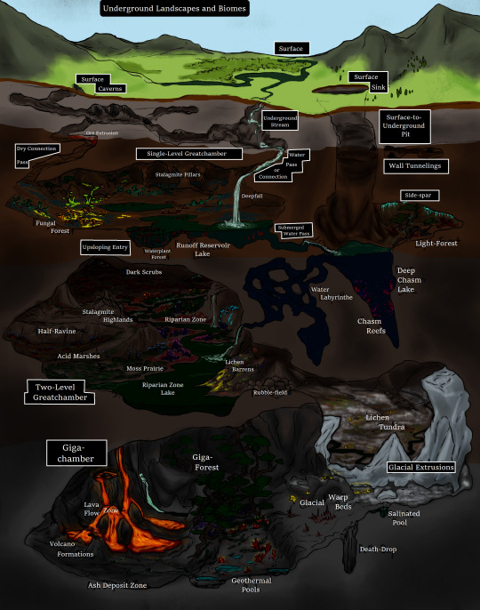
Underground Landscapes and Biomes
To flesh out the grand underside of Ancardia's world, and to emphasize that, rather unlike the standard "big underground area" of fantasy worlds, this Underground is rich with biomass and potential for life--though the life there is very different from that of the Surface. A sample cross-section map of the way the Underground's world is laid out is presented here, with distinctive types of landforms/chamber structures and biomes labelled. I'll start describing from the top-down:
The Surface
The surface of the world, with all its more familiar sorts of deserts, forests, shores and mountains. The Surface technically counts even those caverns of surface-types, even if they lead to passages that access the Underground, meaning the definition of "Surface" includes from the highest mountain top to the deepest ocean trench, as well as every cave or tunnel up to 100 meters below their openings.
Surface Caverns
The more familiar sort of cave that Surface-dwellers would know. Surface caverns can be small cul-de-sacs formed by volcanic activity, wind, or most commonly running water, or vast labyrinthine networks that stretch on for miles. Most are openings formed of hollows in bare rock--light is generally minimal as bio-luminescent organisms are both rare and scarce in this relative desert. Still, these caves do support some life, including a few species which colonize upwards from the Underground such as the Depthmoss lichens and a few small fungi, but most life here consists of small blind fishes and salamanders, insects like crickets, roaches, and springtails, a legion of bat species which only use such places for shelter, and a number of other incidental Surface animals who shelter or den in caves but spend most of their lives outside of them, such as bears, pigeons, gremlins, wolves, packrats and a number of lizards and snakes. Many humanoids also use these caves for habitation, such as the Parrgeg Troll tribes, orders of Druids of Ulderon or of Valas, and all manner of rangers and hunters. Surface Caverns generally max out in height at around 60 meters, and total chamber length or width at 200 meters. Most are far smaller.
Underground Streams
Whether they resurface at some point or not, these intrusions of Surface water into the caves form much of the basis for the ecosystems below for two reasons: Water seep resulting in the abundant fresh water supplies in many areas of the Underground, and as a means for the ancient ancestors of many animals, alga, fungi and plants that adapted to this underworld. Those that bore through soft areas and end up directly in the Underground are often distinguishable by the distinct lack of weak-swimming animal life in them, and will often include only minimal freshwater sponges, suction-cup minnows, and speedier blind eels.
Surface Sink
Sinkholes are not unheard of in Ancardia, but a Surface Sink is a grade above. These land forms are often back-filled with rubble, sand, and especially glacial debris, but this layer of ground forming the basin is seldom very stable, and any intensive digging, building, or even severe weather can result in smaller sinkholes opening up and giving way completely into Surface-to-Underground Pits. These generally range in diameter from 20 meters to 100 meters, and the layer of the clogging debris is generally between 10 and 25 meters thick only.
Surface-to-Underground Pit
These structures are astoundingly dangerous (including the unstable Sinks that cover them up) and can drop vertically down into the Underground levels for over 300 meters straight down. While ledges can exist along the sides of these gaping holes in the earth, many known to exist are actually very smooth-sided due to their formation being glacial in origin. Some of these periodically remain open to the Surface for decades to centuries at a time, introducing shafts of sunlight down into the area below and making these areas some of the brightest-lit in all the Underground. The largest known pit of this type as of the late 14th Age exists in part of the Northwest Drakalors, directly overtop of the Gnumian city of Edipato and its surrounding countryside--this pit extends for 780 meters from the mountainous elevations and the opening itself is about 137 meters in diameter, producing a shaft of sunlight that supports a number of Surface moss species amongst the Underground natives.
Dry Connection or Pass
A Dry Connection, or a Dry Pass, is a tunnel structure of any shape and size that resembles a Surface cave, but notably connects Surface Caverns to a level of the Underground, or a higher level to one along a lower plane. These tunnels contain minimal bodies of water, usually only small pools formed of condensation or small springs seeping into crevices, and the life within these is still fairly scarce, but consists of many more species of Underground lichens, insects, mosses and hardier fungi such as the Dazal'gulr puffball. Sometimes Surface species of rodents or bats may make it down into these tunnels, but usually do not stay long.
Water Connection or Pass
Similar to the Dry Connections, these passages between Surface and Underground are narrower tunnels or tunnel networks. The main exception is that the Water Connection is primarily defined by a Surface waterway descending through softened limestone layers, though generally not completely filled with water. Sometimes Water Connections will become Dry Connections over time as a result of shifting watercourses on the Surface, and in most cases these subterranean rivers are hazardous to navigate due to the substantial current and vertical drops on their way to other water bodies.
Single-Level Greatchambers
The most basic type of Greatchamber, those of the single-level sort make up over one third of the space within the Underground, and are usually connected to several other similar chambers by dry or water connections or to an even larger one. The term "single-level" refers to the average ceiling height and the absence of high escarpments or deep chasms splitting a chamber into multiple levels. These greatchambers range in ceiling height from 100 meters to 250 meters, and are usually several dozen kilometers in at least one other dimension. Chambers this large are capable of generating their own low cloud systems, wind currents, and if separated from other chambers by a narrow enough passage, these weather conditions can be isolated to single areas and differ dramatically from their neighbors.
Wall Tunnelings
Wall Tunnelings are small pockets or caverns excavated by natural forces, creatures, or sometimes as mines or sheltered areas by humanoid beings, notable in that they essentially form a cave within a cave, and offer respites from the weather that exists in the Underground as well as from wild creatures and natural lighting. Many cultures choose to make their infrastructure and homes using wall tunnelings rather than constructing places in the open chambers--these generally include the Murruk Trolls, Minotaurs, some Dwarven groups, and the Underground's Ogres.
Deepfall
A deepfall is a particular type of waterfall existing only in the Underground, defined as one where a running stream or river plunges from one layer of the Underground (or from the Surface Caverns) directly down the full height of a chamber into its destination. Deepfalls frequently generated very turbulent currents and misting around where they make contact with the lakes, rivers, and pools they feed into, and the depth of the lake or river bottom is often deformed into a deadly pit many meters deeper than the surrounding water, almost always full of powerful cycling currents that transform it into a body-trap. Creatures that live in these pits are limited to certain species of freshwater mussels and other sessile invertebrates, or large predators/scavengers capable of immense grip on the bottom surface.
Stalagmite Pillars
These landforms are usually found on the top of natural rises, with many of the stalagmites meeting the stalactites forming from water seep in the ceiling and combining into massive sloping structures. Cracks and crevices along the vertical surfaces of these structures are the typical denning areas of Slypha, a species of large predatory animals closely related to bats, and a number of lichens, mosses, and fungi are specifically known to favor the height and the airflow when growing high up on the pillars. Dark Elves are known to use these stalagmites and the larger pillars as central anchors for their larger buildings and towers, drilling into the pillar itself and building the levels of the edifice around it in a circular pattern of outward-facing rooms.
Fungal Forest
A very common biome found in all levels of the Underground--teeming with dozens of species of fungi, lichens, and also a variety of understory and forest floor plants that live entirely (or almost entirely) off of the light produced by most other species found here. Supported by the fungi, a great many kinds of insects, arachnids, molluscs, and other animals can be found in these places as well, though megafauna is more limited by the thickly-vegetated areas and tougher, fibrous stalks of fungal trees blocking the larger creatures entry into all areas. Giant wolf spiders, Dire Flatback millipedes, greatrats, greatbats, dire violet rove beetles, cave-lions, dire ants, aegiszarl and a host of other creatures are common under the canopy of the mushrooms. For this biome to form, it generally requires a lowland zone of relatively high humidity and generally little to no acidic content in the soil layer.
Runoff Reservoir Lakes
These bodies of water are still, generally with no current whatsoever and not contributing to any streams or rivers, and are fed from deepfalls or more ordinary waterfalls and seeps from the level above. Their stillness contributes to a great deal of aquatic plant life in these lakes, which in turn support a succession of tiny, small, moderate and even some very large animals.
Waterplant Forests
While most common in runoff reservoir lakes, these thick growths of numerous aquatic plant species and their subsequent animal communities can take root in any still or slow waterway. The largest plants are the Deep-lilypads, whose dark magenta leaves can stretch upwards from their roots over 4 meters and the pad itself be over a meter wide. Large varieties of edible plants and alga grow in abundance in the shallows and on the shores, making these common habitats to find grazing Deepwater rats, Deepmara, and a number of millipede, beetle, and other herbivorous creatures, as well as the predators that hunt them.
Submerged Water Connections
These are passages that connect chambers or entire layers of the Underground together through bodies of water, leaving them water-filled tunnels that aquatic creatures often use to migrate between regions. The fauna in these submerged passes are usually highly bio-luminescent, and generally consist of mussels, hydra, moss-animal colonies, sponges, colony algae, and a number of small crustaceans and fishes. Larger semi-aquatic animals also use these passages, most notably dire waterscorpion and cave fishers while hunting for the smaller creatures.
Water Labyrinths
Naturally-occurring networks of winding, honeycombed passages interspersed with small rooms, water labyrinths are uncommon structures in the Underground and generally regarded with fear. Even among the most adventurous and inquisitive societies dwelling in this subterranean land have not fully mapped out the ones that have been discovered, and of expeditions that have ventured into known entrances, only half are known to have come back alive. Even the usually quite confident and skilled Draulfyn gem-divers and their tame cave fishers regard trying to search water labyrinths as crazy. Many of the Underground’s fish species are known to traverse these places, as well as many water insects and crustaceans, but very little of the sessile life has natural bio-luminescence, making these passages one of the darkest places down here.
Deep Chasm Lake
Formed from deep fissures with vertical or nearly-vertical walls, these lakes are rare phenomena but several are known to exist in the middle layer and the deepest layer of the Underground, some with an ordinary lake flooding the area slightly above the chasm and disguising its true depth. These lakes can descend to over 500 meters deep, and the deepest of which is yet to be fully and accurately measured. The waters of these lakes are often a stable if chilly temperature, and below the 200 meter mark they generally include a dense layering of more brackish salinity, along with a whole new range of aquatic life adapted for such saltwater.
Side-Spar
These are rather large cavities form either partway up the walls of a much larger chamber, or formed in the side of a surface-to-underground pit. While smaller than the proper greatchambers, they still accumulate biomass in a similar way and support microbiomes within. One well-known side-spar zone exists on the upper layer, close to Dwarven territory, cut 40 meters up the walls of a high chamber and extending 100 meters into the rock base, with a thick region of Dark Scrub and Lichen Barrens filling it and supporting a large population of Dorn Beasts, which prefer the isolated location for brooding their vulnerable young.
Chasm Reefs
In Deep Chasm Lakes, the fauna and flora differ strongly from those of other types of lakes in the Underground. Clinging to the walls, the creatures developing communities near and below the brackish zones are often bio-luminescent, and consist of moss-animals, hydras, red alga, sponges, frilled clams, tubeworms, and pit-maggots (a species of larviform giant caddisfly). Swimming freely are a number of unique freshwater jellyfish, isopods, unusual fish, and waterworms. While there is some overlap in the pelagic species between the more common lakes and the Chasm Reefs (especially in the waterworms and jellyfish), most others are found nowhere else.
Upsloping Entry
A structure that occurs when two greatchambers from two different layers connect directly together through a wide chamber-sized passage, usually with little shifts in local climate but still very much vegetated and full of wildlife as each greatchamber. The change in elevation can be gradual, or involve several steep cliffs, but usually the altitude change is roughly 150 meters.
Two-Level Greatchamber
The vast majority of the upper layer of the Underground is made up of many of such interconnected greatchambers—containing within them either significant hollow escarpments which create yet another sublayer atop the main ground level, or deep canyon and ravines that open out to deeper sublayers in the form of bowl valleys. Intensive tunneling and road-building by several dominant societies in the Underground renders these sheer climbs and drops much more navigable, but in areas of total wilderness rock climbing experience is recommended for traveling at all between the sublayers.
Dark Scrub
This is a biome consisting largely of drier climates of the Underground, and generally lacks most of the signature fungus species. The plants are also generally those which generate little to no bio-luminescence, and are adapted to be chemosynthetic organisms which feed on a mixture of carbon dioxide and mineral content absorbed by the root systems. Many of the plants living here are highly toxic, and any herbivores living in dark scrub are those adapted to be resistant or immune to plant poisons, such as the Runda Beetle and the blind Deeps Greatrat. Carnivorous creatures found in greater numbers include the Silky Crown Centipede, the Dire Grub-owlfly, and the Ramidreju.
Stalagmite Highland
Highlands are common in the landscape of the Underground, though Stalagmite Highlands are a bit more unusual due to being built up by natural moisture seep, creating sleek limestone formations over the granite and basalt of the normal outcroppings. Due to their origin, most of these regions will be laced with small springs, cataract systems of small waterfalls, and fast-moving creeks which host a number of small water life and support a number of animals, plants and fungi on the rocky substrate. Wherever soil can collect, common dark nettles, glass milkcaps, bloody mycenas and full-moon morning glories grow in clusters, and Wolpertingers are known to den in cavities they excise into the softer spots. Hy’izhur Rats, known for their jaw strength and aggression, are also more common in these places.
Half-Ravine
A half-ravine is a curious landform where one side of a canyon partially erodes, leaving one side much higher and steeper than the other. The cavities that form in the tall side are commonly anchors for the Devil’s Rose plant, and premium roosting sites for the numerous species of greatbats and denning areas for wild Javunwalla. The low side conversely offers a sandy, rocky terrain preferred by Dire Scorpion, Burbroot, Demon Daisy and a number of burrowing rodents and insects.
Acid Marsh
A common form of wetland in the Underground, these marshes form in areas close to erosion of various sulfur-containing rocks, raising the soil and water’s Ph to a range of 5.5 to 6. Species of fungi that grow here are adapted to be tough and wood-like, resembling medium-sized branching shrubs (these are thought to be descended from Surface coral mushrooms), and the plantlife that flourishes is that specifically preferring plentiful water and acidity—with no fewer than 100 species of mosses alone, as well as sundews, nettles, arums, willows, and wild celery adapted to the Underground. The verges of these biomes are thought to be the origins of the dark elves’ first successes in breeding tomato, carrot, and potato plants which could thrive in the climates of Ancardia’s underground realm.
Riparian Zones
Forming large portions of the lowlands in all levels of the Underground, the rivers that criss-cross each layer draw about them an abundance of biomass, soil deposits, and wildlife of all kinds. With few exceptions, most of the well-known species of animals, plants, and fungi of the Underground can be found at least as some times in riparian zones. Most of the peoples of the Underground, when roads are either inconvenient to build or not available, depend on these networks of rivers for travel using barges and rowing vessels, and due to the richness of these areas, many settlements were situated within these biomes, or at least adjacent to them. Megafauna are also commonly known to migrate through these zones due to their water needs, and include Urkklerats, Titan Giraffe-Beetles, Ztsadri (steed-spiders), Dorn Beasts, Cave Bears and Cave Tigers.
Moss Prairie
Another common biome which supports high levels of life is the moss prairie, where thick gravelly silt mixtures become colonized by about 45 species of moss, 12 species of tall lichen, 14 species of mushrooms which form luminous fairy rings, and 20 species of various other low-growing plants. Moss of Mareilon is famously known to grow in greater abundance here, and grazing on the various plants and fungus are herds of animals like Dire Mole Rats, Deepmara, the wild Riding lizards and Wolkangis.
Riparian Zone Lake
Lakes form along Riparian Zones in the Underground very commonly, and can be expected to be up to 30 meters deep at the most, sometimes spanning multiple kilometers in one or more direction, and supporting a huge variety of aquatic crustaceans, molluscs, insects and fishes. The largest known fish species in the Underground, the Colossal Eel, typically lives in the deepest parts of these lakes, hunting low-flying and surface-swimming animals, but these huge creatures (topping out at 7 meters in total length, with a body diameter of 1.5 meters) spawn in the rivers joining these lakes. There are few societies in proximity to one of these lakes that do not cultivate a strong fishing and shellfish-diving industry, with the only exceptions being the Murruk Trolls, Minotaurs, and the Gnoll tribes. Even so, Minotaurs are known to barter for the many species of alga that form mats atop the surfaces, using them as prime fertilizer and mineralizer for their crops. Islands or peninsulas situated within these lakes are commonly regarded as ideal locations for keeps and developed cities, and many of the greatest cities such as Evrethrdral, M’zonathrl, Itsati-Hob, Stronung and Thundigh are located in such a place.
Lichen Barrens
Common on areas with steeper slopes and in the rainshadows of higher or broader regions of a greatchamber, the Lichen Barren is usually quite treacherous and rocky, splashed with colonies of no fewer than 150 species of hardier lichens. Most of these lichens do not grow any part of themselves taller than about 3 cm, but can spread to be several meters across each, sometimes with one organism enveloping an entire boulder amongst other rocks covered by other species. Smaller insect and arachnid species thrive here, including Vuugas tarantula, fire beetle, Uqu cricket and Cave solenoid. Lightning lizards are also often known to pass through these areas along the edges, likely after insect life with somewhat less of a threat level to hunt, and if the barrens occur in an area of colder temperatures on average, Glacial Salamanders sometimes wander in to do the same.
Rubblefield
These places are those in frequent flux, places where destabilization of older soil and sandstone layers cause consistent landslides with weather episodes. Very little permanent life dwells here, but they sometimes attract Dwarven mining interests for the probability that new shifts will dislodge boulders with seams of crystal ethrite (the raw form of mythril), adamantium ore, or reveal seams of other precious materials in the rock wall that was newly exposed. In some cases, Rubblefields form over other, more ancient biomes, and between the cracks in rubble pieces some mosses, lichens and colonies of insects can be found. If they stabilize, these places often become Lichen Barrens.
Giga-Chamber
Making up more than a quarter of each layer of the Underground are what is called Giga-chambers. Much like the two types of Greatchambers, the Giga-chamber is large enough to sustain cloud formation and weather patterns, but since the size discrepancy is so great, the weather that occurs varies and increases in severity to a much greater degree. Summer lightning storms are common in Giga-chambers, which only increases their nutrient density and biodiversity. Most of the regions of Evrek and of Thwervond are comprised by several Giga-chambers directly linked together. The ceiling height of a Giga-chamber frequently exceeds 500 meters, and they very often are more than 25 kilometers in all directions.
Lichen Tundra
The Lichen Tundra is much like a mixture of the Moss Prairie and Lichen Barrens in conditions, being placed on rich soil but with vegetative life suppressed and adapted for seasonal swings due to the proximity of cold spots of arcane energy which generate the Glacial Extrusions. This is the natural habitat of the Glacial Salamander, but also has fairly numerous populations of Uqu cricket, Wolkangis, Greatrats, Dire Weta, Ochotle Light-fly, and one subspecies of the Dori Centipede. On the middle layer, a vast region of this Lichen Tundra falls within Orc territory.
Glacial Extrusions
Formed from a natural uptick in arcane energy in certain regions, these masses of ice protruding from the rock base calve off small true glaciers and produce regions of the Underground which are far colder than most. The only places where it gets cold enough to snow or have any other form of frozen precipitation in this underworld are within or adjacent to these intrusions, such as in Lichen Barrens or Glacial Warp Beds. The glaciers themselves seldom melt permanently, fluctuating with the increased temperatures of the rocks and Surface above, and if smaller glaciers do melt entirely they are often replaced by increased glacial mass dropping from the intrusion. Very little besides microorganisms live on the intrusions themselves, though Glacial Salamanders will often migrate to be nearer to them.
Salinated Pools
Pools of a volcanic vent origin in the Underground can sometimes become highly salinized by the eroded deposits of salt minerals and form a highly dense pocket of water up to 5 meters deep and 5 meters across. Very little except for some highly-specialized colony bacteria can live in such salty conditions, but the presence of these pools allows some settlements to harvest and treat this water to turn it into a form of “sea salt” without having to dig for rock salt deposits. It is extremely difficult to drown in these pools, as they are so dense, but drinking out of one by accident can have dire consequences due to both salinity and the bacteria.
Glacial Warp Beds
These are regions left behind after calved glaciers from the intrusions have melted or moved off, usually grinding at the mineral base of the rock or dragging a new layer of soil onto a scoured stone face. There are often very unusual shapes in the bedrock stone of these areas, sometimes forming alcoves that provide shelter and other times bizarre shapes that bear names based on animals or occupations they looked most like to the first few viewers. Many lichens and smaller plant and fungi live in these zones, mostly those adapted to colder temperatures, as snow and freezing rain do occur in proximity to the parent glaciers.
Death-Drop
Another formation of volcanic origin, these deep pits form when the more brittle lavarock of cooled volcanic formations wears away over time and leaves a large pinhole in the much harder substrate of the rock base. They have been recorded to have depths of up to 65 meters straight down, and are accurately named for any who slips down without any form of harness or a way to slow descent.
Giga-Forest
This form of forest is dominated by a particular tree-like organism that developed in the Underground and closest related to muscadine grape vines on the surface—the Warpwood. While warpwood vines will grow in almost any temperate or tropical temperature biome with average to high humidity and stable soil base, in the Giga-Forest almost all large plant life are exclusively made up of particularly high-climbing specimens, typically with the oldest individuals reaching from the ground level up to between 200 and 500 meters to the ceiling. These vine-like “trees” often bend and twist and wrap around each other and stalagmite structures, their stabilizing tendrils boring into stone and each other in a contest to reach the best anchoring points on the stones above. From the ground to the ceiling, myriad other life from bio-luminescent flowers and mushrooms to bat colonies to Drakotsadr spiders and dire bee-hives are supported by the iron-hard framework of these huge plants. Clawbugs and their larger, more deadly relatives the Ashitovis Bug are particularly partial to these biomes, and travelers are advised to beware also of creatures like Cave Bears, Dori Centipedes, Shi’echar moth larvas, and packs of Dire Hyena.
Geothermal Pools
In proximity to volcanic hotspots rising closer to the floor of the Underground or to the few active Lava Flow Zones in regions of the layers, Geothermal Pools of various types frequently form amongst other biomes, or in areas of bare soil and rock if the chemical composition (high sulfur or high salt content) or sheer temperature negates the growth of most life. Most pools are simply naturally-occurring ponds which are heated to a safe temperature by volcanic hotspots, and host a variety of microbial life such as copepods, diatoms and rotifers—these are attractive locations for both wildlife and humanoid cultures as naturally occurring hot baths, especially so when they crop up in cold regions near glacial intrusions. Some of these pools, however, are dangerously hot and are more utilized by rangers to boil food, as they can reach an average temperature of 210 degrees Celsius and contribute to geyser activity on the layers above or on the Surface. Some pools are not too hot to soak in, but are contaminated with various mineral salts or sulfur compounds that can burn and irritate skin—these pools are lifeless except for a few types of extremophile bacterium, though some Alchemists take interest in them for straining the active salts and chemicals out of them.
Lava Flow Zone
In certain places on each of the three layers of the Underground, pockets of upwardly-pressed magma not only form zones where geothermal pools are likely, but break through tiny weaknesses in the rock base and form hot, dry regions with layers of solidified lavarock interspersed with active and dangerous streams of lava flow. The amount and cooling of the lava in these areas is dependent largely on the rotation of Ancardia’s world, which draws the magma base down in times of low pressure and means less of the rock remains molten, and the opposite at other times. The Aggbrun, or Fire Lizards, prefer areas in certain proximity to these lava flows for incubating their nests, and the adults are well-known for traversing even the still-cooling lavarock. While dangerous, Dwarves, Kobolds, Gnolls and Ratling traders all make repeated trips into the lavarock to recover rare minerals and crystals formed or carried there by the active lava streams—this is one of the few places in all of Ancardia to reliably find any significant amount of Eternium ore, and also frequently gives up diamonds, rubies, high-quality iron and deposits of crystalline platinum and adamantium.
Volcano Formations
Within the most long-lasting Lava Flow Zones are a rare few places where small volcanic cones have had time to form, spouting sulfurous smoke and ash and leaking lava streams for century-long periods and experiencing dormancy for centuries between. Unique chemosynthetic fungi and lichens tend to cluster around the stalagmites and ceilings in the chambers containing these volcanoes, feeding on the sulfur compounds and methane released. Without these hardy species, active volcanic periods would jeopardize the other life in the chambers, both from air quality and toxicity of the fumes.
Ash Deposit Zones
In places downwind of the Underground’s volcanoes, Ash Deposit Zones tend to form, with a soil content that is mostly ash and worn-down pumice rock spewed by the volcanic activity. While superficially resembling a pale gray desert, these areas are usually possessing of decent groundwater and frequent volcanically-triggered rainfall from the chamber ceilings, and these one support a great deal of tough and specially-adapted plantlife. It is these regions which are the ideal places to find Morgiaroot growing—a taprooted, wiry-leaved plant with notable medicinal uses.
#biomes#fantasy#landscape#map#resource#underground#underworld#ancardia#example#Ancardian Homebrew#fantasy ecology#fantasy biomes#fantasy landscapes#DnD-like#cross-section#the Underground
28 notes
·
View notes
Last Seen Blogs

nsr-scrapped-records
I do it for NSR!

ohhi-itsme
The Great Wide Somewhere

serial-contraption-of-malice
*robot noises*

randomrabbidramblings
Lost in the Phantastic Phantom Phandom

bitsobitso
aka @fruitpunching