#glacial erosion
Text

#can’t decide what area in BotW this landscape most closely resembles#ancient lava flow warn down by glacial erosion#now scrubby grasslands#very dry very hot very windy#IRL Vantage WA
2 notes
·
View notes
Text
you ever think of the inherent eroticism of glacial erosion
the inexorably slow motion of ice against stone, dragging across the landscape like a lover's fingernails against skin. two bodies from different worlds moving against each other, their romance lasting eons and leaving both utterly changed.
also sometimes boulders get deposited
67 notes
·
View notes
Text


I had a realization while playing the new Pokemon DLC
These are pictures of the areas surrounding the four shrines containing the ruinous quartet, and now that I'm looking for it, I can see evidence of each one on the local environment.
>Chi-Yu's shrine is surrounded by massive spires of blasted obsidian sprouting from solid rock
>Chien-Pao's shrine is surrounded by striations and gouge marks in the mountainside that're highly reminiscent of glacial retreat marks and ice-erosion
>Wo-Chien's shrine is at the bottom of a massive basin filled with irregular, atypical lakes and ponds, that look to have been gouged out of the ground itself
>Ting-Lu's shrine is underneath a massive rock formation sitting in the middle of a lowland plain - a rock formation with no natural plantlife, and totally disconnected from the natural mountains of Paldea
Like holy shit, the name "Ruinous Quartet" is not an exaggeration! I would fully believe these four pokemon alone were enough to cause an extinction event in Paldea's past, we can still see the catastrophic effects of their power!
#pokemon#pokemon scarlet and violet#ruinous quartet#chi yu#chien pao#wo chien#ting lu#this is some A+ environmental storytelling!!#the games always say legendaries are these superpowered demigod beings#but usually its just them doing something impressive in cutscenes#THIS is not a cutscene!
53 notes
·
View notes
Text


Ülkemiz yemyeşil ormanlara, muhteşem sahillere, benzersiz doğal oluşumlara ev sahipliği yapıyor. Bununla birlikte Türkiye'de son derece nadir hatta eşi benzeri olmayan doğal yapılar da var. Her ne kadar fazla bilinmese de onlardan en ünlü ve en şaşırtıcı olanı Konya il sınırları içerisinde yer alan Karapınar Çölü.
🔸Karapınar Çölü, şehir merkezine yaklaşık 100 kilometre uzaklıktaki Karapınar ilçesinde bulunuyor. Konya Havzası’ndaki en kurak yerlerden biri olan Karapınar aynı zamanda ülkemizin en az yağış alan noktası konumunda. Türkiye’nin tek çölü ünvanına sahip olan Karapınar, yüzyıllar süren volkanik faaliyetlerin bulunduğu bir coğrafya üzerinde yer alıyor.
🔸Karapınar Çölü’nü oluşturan temel şey, uzun zaman önce bölgede yer alan buzul gölleri. Eski bir göl tabanı olan Karapınar bölgesindeki topraklar, yıllar süren kuraklık ve rüzgar erozyonu nedeniyle çöl haline gelmiş durumda. Çölleşmeden yaklaşık 103 bin hektarlık bir alan etkileniyor.
🔸Karapınar aynı zamanda rüzgâr erozyonuna karşı etkin bir mücadelenin yürütüldüğü bir alan. 1950’lı yılların sonunda, Karapınar’ın çölleşmesini önlemek adına rüzgâr erozyonuna karşı başlatılan mücadele, bugün çölde yeşil arazilerin ve kullanılabilir tarım alanlarının ortaya çıkmasına katkı sağladı. Öyle ki Karapınar yeryüzündeki en yeşil çöllerden biri olarak kabul ediliyor
Kaynak: Instagram/@listelist
.......
Türkiye 🇹🇷
Our country is home to lush forests, magnificent beaches and unique natural formations. However, there are also extremely rare and even unique natural structures in Turkey. Although it is not well known, the most famous and surprising one is the Karapınar Desert, located within the borders of Konya province.
🔸Karapınar Desert is located in Karapınar district, approximately 100 kilometers away from the city center. Karapınar, one of the driest places in the Konya Basin, is also the point with the least rainfall in our country. Karapınar, which has the title of Turkey's only desert, is located on a geography where volcanic activities lasted for centuries.
🔸The main thing that makes up the Karapınar Desert is the glacial lakes that were in the region a long time ago. The lands in the Karapınar region, an ancient lake bottom, have become desert due to years of drought and wind erosion. An area of approximately 103 thousand hectares is affected by desertification.
🔸Karapınar is also an area where an effective fight against wind erosion is carried out. The fight against wind erosion launched at the end of the 1950s in order to prevent the desertification of Karapınar contributed to the emergence of green lands and usable agricultural areas in the desert today. So much so that Karapınar is considered one of the greenest deserts on earth.
Kaynak: Instagram/@listelist
#desert#çöl#Karapınar çölü#konya#türkiye#doğa#travel photography#travel destinations#travel#manzara#view#natural#europe#africa
30 notes
·
View notes
Text
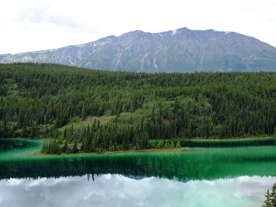

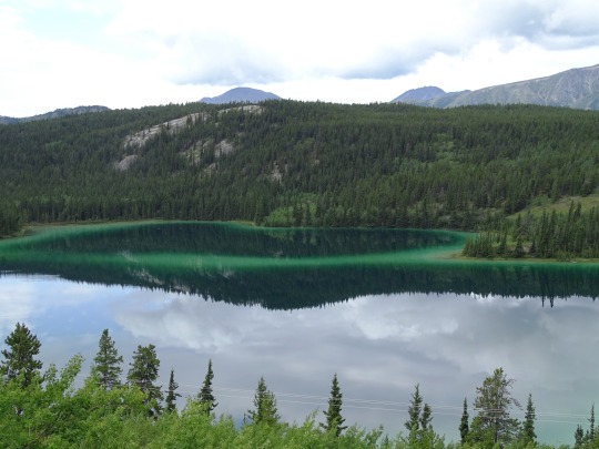


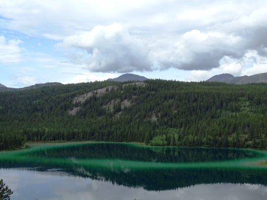
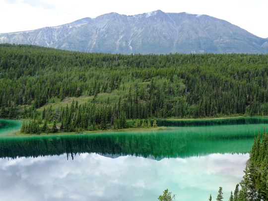
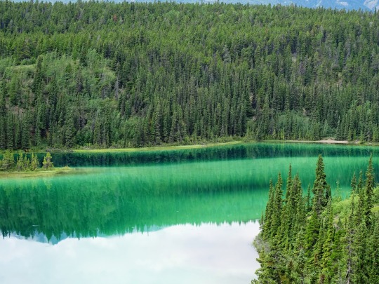

Emerald Lake, YT (No. 1)
Emerald Lake is a lake in the southern Yukon, notable for its intense green colour. It is located on the South Klondike Highway at kilometre 117.5 (mile 73.5), measured from Skagway, Alaska. The colour derives from light reflecting off white deposits of marl, a mixture of clay and calcium carbonate, at the bottom of the shallow waters.
The high concentration of calcium carbonate in the water here comes from limestone gravels eroded from the nearby mountains and deposited here 14,000 years ago by the glaciers of the last ice age. Glacial erosion was likewise responsible for scooping out the shallow lakebed.
Natural hypoxic conditions during the summer may contribute to carbonate deposition and marl formation.
Source: Wikipedia
#Emerald Lake#Klondike Highway#Surprise Mountain#travel#original photography#vacation#tourist attraction#landmark#landscape#countryside#reflection#Yukon#the North#Canada#summer 2023#green water#Rainbow Lake#flora#nature#woods#forest#fir#clouds
8 notes
·
View notes
Text
geology things that feel like gay sex but aren't:
schistosity
dykes and sills
taking samples with a hammer
glacial erosion
17 notes
·
View notes
Photo
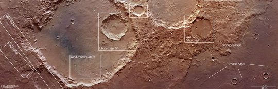
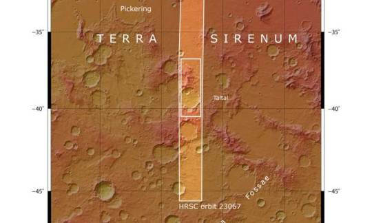
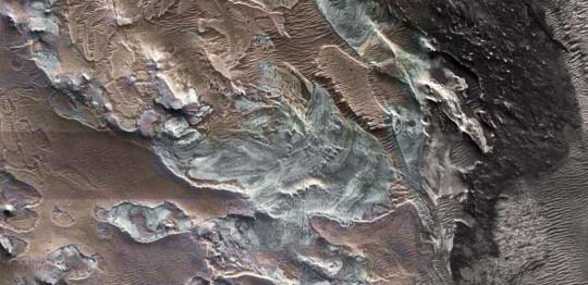
Craters and cracks on Mars' Terra Sirenum region This complex region of craters and fractures in the Terra Sirenum region highlights the varied history of Mars. The image above was taken by ESA's Mars Express on 5 April 2022. The image, taken by the High Resolution Stereo Camera (HRSC), is dominated by a large impact crater on the left (south) of the image, which measures about 70 km wide. This crater is in the Terra Sirenum region of Mars, which lies in the southern hemisphere. Another area of the same region was imaged by Mars Express in 2017. The imprint of Martian wind is detectable within the crater—in the lower, eastern part of the crater, rough features known as yardangs are visible signatures of wind erosion. The contrasting dark-toned sand within the crater may have been transported into the flat base by wind. Clues left by water Nestled within the large crater is a smaller crater measuring about 20 km wide. The smaller crater and its neighbor can be seen in staggering detail in the perspective view. The structure and outline of the crater, and its smaller neighbor in the background of the perspective image, suggest that water or ice may have covered this surface when the impact occurred. Signatures of past glaciers are visible in the smooth surface of the two neighboring craters in the perspective image. The glaciers are thought to be made from a mixture of debris and ice, which flow downhill. The sedimented debris leaves clues about the direction and movement of the ice through the small sweeping channels in the base of the craters. Water also leaves its mark in other parts of the scene. The winding valley on the far left of the main color image measures up to 1.8 km in width. It is thought to have been a pathway for water which melted in the basin to the east. The right (north) side of the image showcases a complex region of twisting valleys, known as dendritic valleys, whose origins are believed to be due to rain or snow early in Martian history. Tectonic stress The surface of the Red Planet is marked by the dynamic movements of the martian crust. Parallel to the large valley at lower left in the main color image, and about 10 km away, lies a fracture which cuts through the basin. When the crust is pulled apart by tectonic stress, parts of the surface drop downward creating the faults. These "graben" can also be found in a region called Icaria Fossae, marked on the context map. Lava also makes its mark on the surface in two sections of the image of the region. While the larger crater has glacial signatures, the impact crater in the north shows signs of a layer of lava on the crater floor (labeled as the "lava filled crater" in the top image). Small slivers, called wrinkle ridges, are marked in the lower right corner of the image. These are formed when a soft lava sheet is compressed by tectonic forces, causing a ridge where the material buckles over the lava sheet. The array of features visible in one image shines a light on the varied physical processes and history of the Red Planet.
62 notes
·
View notes
Note
Was the vale by glacial erosion
It is indeed!
The Vale is what’s known as a “cirque” (also known as a “corrie” or “cwm”): a bowl-shaped, amphitheater-like valley formed by glacial erosion.
Glaciers will melt, flowing up and over the lip of the beginnings of this valley, pooling over and ultimately carving out a deep depression within the earth - though for the Vale specifically, this glacier never stopped melting, resulting in the waterfall that flows into the Vale that, in turn, resulted in the constant, thick fog that became humid, and fed the lush forest that eventually grew there to hold host, ultimately, to the Four-Trees Fealty.
9 notes
·
View notes
Text
Unveiling the Mystery Why is There Coal on the Beaches of Alaska?
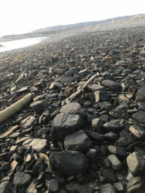
Alaska's rugged coastline is renowned for its breathtaking beauty and pristine wilderness. However, amid the stunning scenery lies a curious phenomenon - coal scattered along its beaches. The presence of coal in such an environment raises intriguing questions about its origins and how it came to rest on these remote shores.

Natural Formation: Coal, a fossil fuel formed from the remains of ancient plants, typically accumulates in underground seams over millions of years. However, geological processes such as erosion, weathering, and tectonic activity can expose these coal deposits and transport them to the surface. In the case of Alaska, the state's extensive coal reserves are primarily found in the interior regions, particularly in areas like the Matanuska Valley and the North Slope.
Transportation Mechanisms: The journey of coal from inland deposits to coastal beaches is facilitated by various natural mechanisms. Rivers and streams act as conduits, carrying eroded coal particles downstream towards the ocean. Glacial activity also plays a significant role, as glaciers grind against rocks and sediment, incorporating coal particles into their icy masses. When glaciers eventually calve and retreat, they release these coal-laden sediments, which are then transported by ocean currents and deposited along the shoreline.
Historical Significance: The presence of coal on Alaska's beaches has historical significance, dating back to the late 19th and early 20th centuries when coal mining operations were prevalent in the state. During this time, coal was a valuable resource used for heating, industrial purposes, and powering steamships. Mining activities led to the extraction of vast quantities of coal from inland deposits, some of which found their way to coastal areas through natural transport processes. Additionally, coal may have been inadvertently spilled or discarded during transportation, contributing to its presence on the beaches.
Environmental Implications: While the presence of coal on Alaska's beaches may seem innocuous, it raises concerns about potential environmental impacts. Coal contains various pollutants, including heavy metals and sulfur compounds, which can leach into the surrounding soil and water, posing risks to aquatic ecosystems and wildlife. Furthermore, the combustion of coal releases greenhouse gases and other pollutants, contributing to air pollution and climate change.
Conclusion: The presence of coal on the beaches of Alaska is a testament to the dynamic geological processes that shape our planet's landscapes. While natural mechanisms play a significant role in transporting coal from inland deposits to coastal shores, human activities such as mining and industrialization have also left their mark on the environment. Understanding the origins and implications of coal on Alaska's beaches underscores the complex interplay between geology, ecology, and human intervention in shaping our world.
2 notes
·
View notes
Text
The Silent Predator: Unmasking the Damaging Effects of Eroding Land
Soil erosion can have devastating effects. It removes humus and plant nutrients from the soil, contaminates water and causes erosion-related road damage.
Erosion also leads to increased sedimentation in bodies of water. This clogs streams and causes flooding. It also changes the chemistry of the water and destroys freshwater habitats.
Soil Erosion
Soil erosion occurs when wind or water loosens and breaks up dirt particles that were previously held in place by vegetation, exposing deeper soil. This exposes less nutrient-rich soil and often carries the particles into lakes, rivers and oceans where they disrupt ecosystems and create conditions that are unfavorable for growth.
Several factors contribute to soil erosion, including climate and human activities. When natural plants are cleared for agriculture fields, they can no longer hold the land together and soil erosion becomes more likely. Farmers who till (plow) their land or overgraze livestock can also disturb the topsoil, increasing erodibility. Soil that has been exposed to erosion in the past is more erodible than undisturbed soil because of its lower organic content and compacted structure.
Physical erosion is the most common type of soil erosion. This type of erosion is accelerated by raindrop splash, wind and glacial movement. It is most noticeable on uniform slopes, in low areas and on knolls where the topsoil is thinner. Physical erosion can also cause landslides and avalanches. This type of erosion can be reduced by planting grass and trees, removing rocks from unstable slopes and maintaining ground cover with mulch or compost. In addition, humans can help slow erosion by using conservation methods to maintain or increase soil health and putting erosion-prevention measures at the heart of their land management policies.
Vegetation Erosion
The most common type of erosion is wind erosion. It happens when bare soil is exposed to high-velocity winds. It's exacerbated by land clearing, agribusiness practices, and improper crop cultivation, including excessive fertilizers and herbicides.
The erodibility of soil depends on its texture, surface composition and climatic conditions. Loam-textured soils and sandy and silt-textured soils are generally less erodible than clay-textured soils. The amount of vegetation on a slope also influences its erodibility. Plants and crop residue reduce erosion by holding soil particles in place, especially in unsheltered areas with little or no windbreaks.
Erosion from agricultural land often carries pesticides, fertilizers and other chemicals that can pollute downstream waters. Sediment that reaches rivers and lakes can clog waterways, disrupt fish habitat and contaminate drinking water supplies.
Soil erosion is a natural process, but if it occurs too quickly, it becomes a problem. It removes the topsoil that is rich in nutrients needed to sustain crops and animals. This eroded soil carries away dissolved minerals and other substances that can damage or kill plants. The result is lower crop yields, degraded pastures and more frequent flooding. In the long run, it can also lead to desertification. This cycle is accelerated by climate change, which causes more rain and higher temperatures. These conditions rob the soil of its ability to hold onto water, aggravating floods and droughts.
Water Erosion
Water erosion is a natural process that involves the washing away of soil particles from the surface of land. The moving soil can either form new land or be carried to water reservoirs (streams, rivers, lakes).
Water erodes land at a slower rate than wind, but it can still carry away valuable topsoil. Erosion from rain or snowmelt is most severe on bare, exposed land. This includes crop fields that have been left unplanted after harvest or areas where vegetation has been removed for construction.
The force of flowing water erodes the landscape by breaking apart rocks, scouring away soil and carrying it downstream. The eroding material, also called sediment, can obstruct stream and drainage channels, damage the bank of a river or reservoir and contaminate downstream water sources, wetlands and lakes. Pesticides and fertilizers that are transported with the eroded soil often pollute the water.
The causes of water erosion include a combination of factors such as rainfall intensity and duration, soil compaction, tillage practices and the type of soil. Planting crops that are resistant to erosion, terracing sloped land and incorporating ground cover like grasses can help reduce the amount of sediment carried by water runoff. For serious problems, structural controls such as grassed waterways, grade control structures and rock chutes can be installed to protect a field or an embankment from washout.
Flood Erosion
During a flood, water wears away eroded soil and rocks, and sometimes transports them from one location to another. This process is called erosion by water and can be caused by rain, snowmelt, or the failure of dams and levees. Flood erosion can cause soil degradation, sedimentation, and damage to vegetation. It can also clog rivers and streams, leading to harmful algae blooms and killing fish.
Natural factors that impact how fast erosion occurs include climate, topography, vegetation, and tectonic activity. Climate influences how much rainfall or wind can erode an area’s surface, and it determines the likelihood that weathered materials will be transported during a rainstorm or breeze. Topography affects how eroded an area will look, with valleys and hills more prone to erosion than flat areas. Vegetation is a major factor in the rate of erosion, with plants’ roots attaching to the ground and preventing it from being carried by storms or wind.
Erosion can be accelerated by the movement of ice and glaciers, a process known as glacial erosion. This is particularly common in frigid regions and on some mountaintops, where moving ice scrapes against rock and dirt, eroding it from both the surface of the ground and the rocks below. Erosion by ice can even create dramatic landforms, such as the swirling rock spires of Coyote Buttes in Arizona and the carved canyons of Namibia’s Fish River.
2 notes
·
View notes
Text
A Journey Through Norway
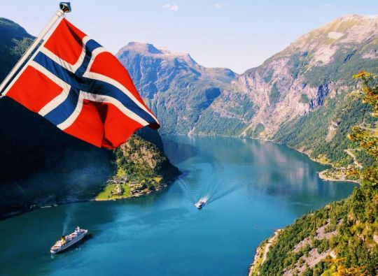
Norway, officially the Kingdom of Norway, is a nation in northern Europe's western Scandinavian Peninsula. Svalbard and Jan Mayen are included in the 148,449 sq mi (384,483 sq km) total area. Estimated population in 2023: 5,526,000. Norwegian capital. Although there are various ethnic minorities, including between 30,000 and 40,000 Sami (Lapps), the majority of the population is Norwegian. Norwegian and Sami are the official languages. Religion: Christianity (officially, Evangelical Lutheranism is the predominant form). currency: krone of Norway. Norway is one of the biggest nations in Europe. It is a hilly country with substantial plateau areas in the southwest and center. It has a developed economy mostly centered on services, petroleum and natural gas extraction, as well as light and heavy industries. Historically a fishing and logging country, it has considerably grown its mining and industrial operations since World War II. Literacy is almost universal.
Norway is a constitutional monarchy with a single parliamentary chamber; the king serves as the country's head of state, while the prime minister serves as the head of government. In the eleventh century, a number of principalities were combined to become the kingdom of Norway. From 1380 until 1814, when it was given to Sweden, it shared a ruler with Denmark. When the union with Sweden was broken up in 1905, Norway's economy expanded quickly. Despite the fact that its shipping industry was crucial to the war effort, it stayed neutral throughout the fight. Despite having declared itself neutral during World War II, German forces invaded and seized the area. Norway is a member of NATO and maintains a robust welfare system. In 1994, its citizens rejected joining the European Union.
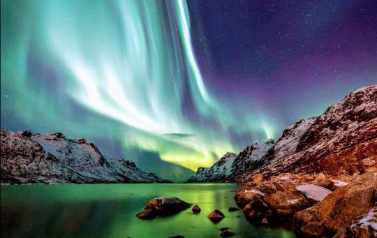
Northern lights, Norway
The stark natural beauty of Norway has drawn tourists from all over the world. Other notable artists from the nation include playwright Henrik Ibsen, composer Edvard Grieg, painter Edvard Munch, writers Knut Hamsun and Sigrid Undset, and composer Edvard Grieg. Ibsen made the following observation about his own land and its reflective citizens: "The gorgeous, but severe, natural environment surrounding people up there in the north, the lonely, secluded life—the farms are miles apart—forces them to...become introspective and serious. At home every other person is a philosopher!"
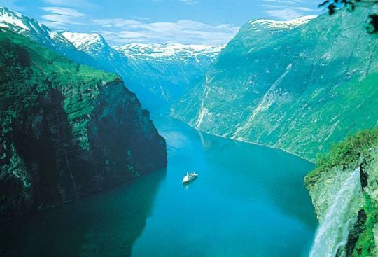
Fjord, western Norway
Westward flowing rivers had a powerful erosive force. They carved out gorges and canyons that sliced deeply into the rugged coast, following fracture lines denoting weak spots in the Earth's crust. The terrain slopped more gently to the east, creating wider valleys. The magnificent U-shaped drowned fjords that now adorn the western coast of Norway were created by glaciers tonguing down the V-shaped valleys that were part of the landscape during repeated periods of glaciation in the Great Ice Age of the Quaternary Period (i.e., roughly the last 2.6 million years). Glacial action also transported enormous quantities of soil, gravel, and stone as far south as modern-day Denmark and northern Germany. The bedrock, which is exposed in roughly 40% of the area.
Climate of Norway
Although it occupies almost the same degrees of latitude as Alaska, Norway owes its warmer climate to the Norwegian Current (the northeastern extension of the Gulf Stream), which carries four to five million tons of tropical water per second into the surrounding seas. This current usually keeps the fjords from freezing, even in the Arctic Finnmark region. Even more important are the southerly air currents brought in above these warm waters, especially during the winter.
The mean annual temperature on the west coast is 45 °F (7 °C), or 54 °F (30 °C) above average for the latitude. In the Lofoten Islands, north of the Arctic Circle, the January mean is 43 °F (24 °C) above the world average for this latitude and one of the world’s greatest thermal anomalies.
Western Norway has a marine climate, with comparatively cool summers, mild winters, and nearly 90 inches (2,250 mm) of mean annual precipitation. Eastern Norway, sheltered by the mountains, has an inland climate with warm summers, cold winters, and less than 30 inches (760 mm) of mean annual precipitation.
Cultural institutions
Permanent theatres have been established in several cities, and the state traveling theatre, the Riksteatret, organizes tours throughout the country, giving as many as 1,200 performances annually. The Norwegian Opera, opened in 1959, receives state subsidies (as do most other theatres).
In addition to its National Art Gallery, Oslo opened a special museum in 1963 to honour Edvard Munch, credited as one of the founders of Expressionism and as Norway’s most famous painter. The Sonja Henie–Niels Onstad Art Centre, opened in 1968 near Oslo, contains modern art from throughout the world. Oslo is host to many other museums, including the Ibsen Centre, which honours the famed playwright, and the Resistance Museum, which documents Norway’s struggle against Nazi occupation during World War II. Outside Oslo, the Tromsø Museum’s collection records Sami heritage.
EXPENSES
The expenses for traveling to Norway from the Philippines can vary widely depending on factors like the duration of your stay, type of accommodation, activities, and personal preferences. Here are some estimated costs to consider:
Flights: The cost of round-trip flights can vary depending on the time of booking, airline, and travel dates. On average, you might spend between $800 to $1,500 or more.
Accommodation: Accommodation costs can vary from budget hostels (around $40-$100 per night) to mid-range hotels ($100-$250 per night) and luxury hotels ($250+ per night).
Food: Dining out in Norway can be expensive. Expect to spend around $20-$50 for a meal at a mid-range restaurant. You can save money by eating at more budget-friendly places or preparing your own meals.
Transportation: Local transportation in Norway, such as buses and trams, can be costly. A one-way ticket might cost around $3-$4. If you plan to travel between cities, train or bus tickets will vary in price.
Activities: The cost of activities and attractions can vary, but expect to spend on average $20-$50 per attraction or activity.
Travel insurance: Consider the cost of travel insurance to protect yourself during your trip.
Visa fees: If you need a visa to enter Norway, there may be associated fees.
Miscellaneous: Don't forget to budget for souvenirs, additional personal expenses, and unforeseen costs.
Overall, a moderate daily budget for a comfortable visit to Norway can range from $100 to $200 or more, depending on your spending habits and travel style. Be sure to plan and budget according to your specific travel plans and preferences.
ENJOY YOUR JOURNEY TO NORWAY
Reference:
Charles Jays, Gudmund Sandvik, Jorgen Weibull & The Editors of Encyclopedia Britannica (2023).
https://www.britannica.com/biography/Harald-I-king-of-Norway
# Travel # Create New Journey # Photography # aesthetic
4 notes
·
View notes
Note
Here's something I was thinking about irt Cybertron and its gnarly space ingredients: Cybertron has only had one mass extinction event. Two if you count the war. Whereas on Earth we're on number 6 if you just count the big ones. I'm thinking that there's something about Earth that makes our evolutionary turnover rates crazy fast compared to the rest of the galaxy. Maybe it's the chaos god robo-cocaine.
Make that 7; the Capitanian extinction event is a Big One in its own right. :D And there's two in the Cambrian and one at the end of the Ediacaran that also likely measure highly in severity, it's just that we know shit all about them due to very little preserved evidence.
(and then also consider that Cybertron's civilization lasted for like 4 billion years and they only have two extinction events to show for it, one of which is self-inflicted, vs. Earth, with between 7 and 20 mass extinction events depending on who u ask, within only about 542 million years.)
Anon u have no idea how much I love this idea, I'm folding it into my TF Belief System effective immediately <333
Here's the thing: plate tectonics, and things that are probably mostly related to plate tectonics, are implicated* in not just all of the big mass extinction events (prior to the current one, which is really just our fault) but also like... most of the smaller ones too. Plate tectonics as they work on Earth are pretty much just an Earth thing - there are other planets which have some sort of tectonic activity, but none of them match our mobile-lid style.
*correlation vs. causation is in question for a lot of these; eg. how much of a role Deccan Traps volcanism played in the K-PG extinction vs the Chicxulub impactor is up for debate. With that said, it's likely that in most cases mass extinctions occur via a number of processes which all kind of interact and make each other worse. (It's just that several of those individual processes might be ultimately caused by the stuff we fold under the umbrella of 'plate tectonics.)
What's probably mostly related to plate tectonics? A good chunk of large igneous provinces - both associated with the opening of ocean basins (CAMP, NAIP, Karoo-Ferrar etc.) and the closing of them (Emeishan, Wrangellia). Significant (non-glacial) sea level changes, and changes in ocean current circulation, both in response to reorganization of continents in regards to each other. Significant climatic changes - as a result of large-scale volcanism, or just large-scale increases in weathering/erosion caused by mountain-building. And a bunch of other second- and third-order phenomena that can result from all of the above things, such as episodes of ocean anoxia, large-scale degassing of various shit out of volcanics into the atmosphere, ocean acidification, so on and so forth. You can even link the current icehouse period to plate tectonic processes, although the icehouse climate itself isn't thought to have much to do with extinction rates beyond creating a climate which worked great for the eventual rise of humans...
What causes plate tectonics? We think it has something to do with convection cells in the mantle, but tbh we kind of aren't sure. The main driver of plate motion is subduction - plates essentially being pulled down into the mantle. How did this get started? And also when? There's evidence of some form of plate tectonics from very early in our planet's history, but whether this is similar to modern regimes, and whether it has continued to the modern day or quit and had a break for a while... there's a lot of uncertainty.
So, looking at this from a TF-specific lens... 👀👀👀

I genuinely think that making Unicron be the actual core of Earth is one of the most interesting sci-fi worldbuilding decisions TF canon has made. There are SO MANY IMPLICATIONS. You could tie it in to the Giant Impact Hypothesis and the creation of the goddamn moon, potentially the LLSVPs (which may be the source of some hotspots), the motion of the mantle, initiation and drivers of plate tectonics, and through that the supercontinent cycle, and all of the fun stuff I mentioned above. And THEN there's also the question of how intertwined these things are with the development of life.
(and that's without getting into the chaos-god robo-cocaine. XDD)
#ok im gonna stop here bc this could go on for a loooong time lol#fun fact: there's a hypothesis that part of the late devonian mass extinction was also sorta self-inflicted lol#basically trees evolved and made a shit ton of soil#soil speeds up weathering of rocks#and results in a sudden increase in nutrients delivered to the ocean#high nutrient supply is actually Bad for a lot of living things#and then all the trees might have sucked a lot of CO2 out of the atmosphere and cooled the planet#and THEN there's some LIP volcanism happening around the same time#which probably wouldn't have helped lmao#the tf geology tag#unicron#tfp
47 notes
·
View notes
Text
The Fairy Glen, Scotland
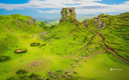
This lush landscape in the hills above the village of Uig, on the Isle of Skye in Scotland, has a name to match its fantastical appearance. With its stepped, conical hills, buttes, lochans (ponds) and copses of gnarled trees, the Fairy Glen is an otherworldly valley created by a series of small landslides. Here on Trotternish, the most northerly peninsula on Skye, the whole landscape is a labyrinth of steep slopes, plateaus and dramatic rock formations, thanks to an ancient landslip which runs for more than 30 kilometres.
The Fairy Glen is like a miniature version of the much larger Quiraing landslip further up the peninsula and is a popular spot with photographers. These days, the concentric circles and spirals of stones you see here are a bit controversial. They are considered a nuisance created by tourists, and locals will remove them, preferring to keep the glen as nature intended. The flat basalt-topped hill in the middle of our image is known as Castle Ewan, for reasons unknown. It is not a ruined castle, but does offer great all-round views of this magical place, sculpted by landslides, glacial movement and erosion (or as a bridge between our world and the fairy world, depending on what you believe).
4 notes
·
View notes
Photo


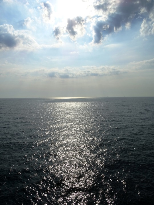

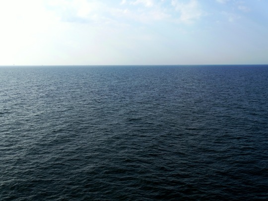
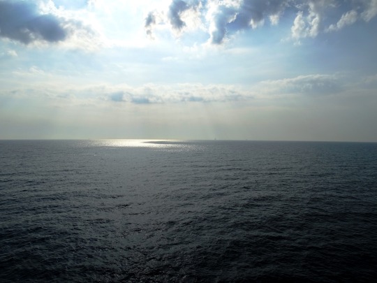


En Route to Germany (No. 6)
An arm of the North Atlantic Ocean, the Baltic Sea is enclosed by Sweden and Denmark to the west, Finland to the northeast, and the Baltic countries to the southeast.
It is about 1,600 km (990 mi) long, an average of 193 km (120 mi) wide, and an average of 55 metres (180 ft) deep. The maximum depth is 459 m (1,506 ft) which is on the Swedish side of the center. The surface area is about 349,644 km2 (134,998 sq mi) and the volume is about 20,000 km3 (4,800 cu mi). The periphery amounts to about 8,000 km (5,000 mi) of coastline.
The Baltic Sea is one of the largest brackish inland seas by area, and occupies a basin (a Zungenbecken) formed by glacial erosion during the last few ice ages.
Source: Wikipedia
#en route to Germany#MS Huckleberry Finn#TT-Line#on board a ferry#travel#summer 2020#Sweden#Sverige#Scandinavia#Northern Europe#Ostsee#Baltic Sea#water#horizon#morning light#reflection#sunrays#vacation#original photography#nature#seascape#ship#engineering
3 notes
·
View notes
Text
we need to open up the conversation on landforms of glacial erosion
1 note
·
View note
Photo

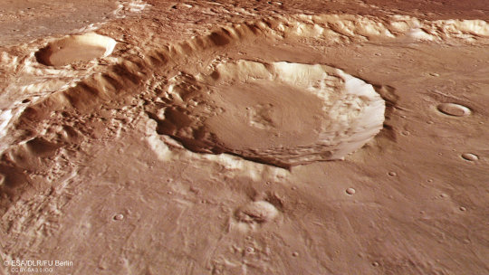
Modern glacier remains found near Mars equator suggest water ice possibly present today at low latitudes In a groundbreaking announcement at the 54th Lunar and Planetary Science Conference held in The Woodlands, Texas, scientists revealed the discovery of a relict glacier near the equator of Mars. Located in Eastern Noctis Labyrinthus at coordinates 7° 33' S, 93° 14' W, this finding is significant as it implies the presence of surface water ice on Mars in recent times, even near the equator. This discovery raises the possibility that ice may still exist at shallow depths in the area, which could have significant implications for future human exploration. The surface feature identified as a "relict glacier" is one of many light-toned deposits (LTDs) found in the region. Typically, LTDs consist mainly of light-colored sulfate salts, but this deposit also shows many of the features of a glacier, including crevasse fields and moraine bands. The glacier is estimated to be 6 kilometers long and up to 4 kilometers wide, with a surface elevation ranging from +1.3 to +1.7 kilometers. This discovery suggests that Mars' recent history may have been more watery than previously thought, which could have implications for understanding the planet's habitability. "What we've found is not ice, but a salt deposit with the detailed morphologic features of a glacier. What we think happened here is that salt formed on top of a glacier while preserving the shape of the ice below, down to details like crevasse fields and moraine bands," said Dr. Pascal Lee, a planetary scientist with the SETI Institute and the Mars Institute, and the lead author of the study. The presence of volcanic materials blanketing the region hints of how the sulfate salts might have formed and preserved a glacier's imprint underneath. When freshly erupted pyroclastic materials (mixtures of volcanic ash, pumice, and hot lava blocks) come in contact with water ice, sulfate salts like the ones commonly making up Mars's light-toned deposits may form and build up into a hardened, crusty salt layer. "This region of Mars has a history of volcanic activity. And where some of the volcanic materials came in contact with glacier ice, chemical reactions would have taken place at the boundary between the two to form a hardened layer of sulfate salts," explains Sourabh Shubham, a graduate student at the University of Maryland's Department of Geology, and a co-author of the study. "This is the most likely explanation for the hydrated and hydroxylated sulfates we observe in this light-toned deposit." Over time, with erosion removing the blanketing volcanic materials, a crusty layer of sulfates mirroring the glacier ice underneath became exposed, which would explain how a salt deposit is now visible, presenting features unique to glaciers such as crevasses and moraine bands. "Glaciers often present distinctive types of features, including marginal, splaying, and tic-tac-toe crevasse fields, and also thrust moraine bands and foliation. We are seeing analogous features in this light-toned deposit, in form, location, and scale. It's very intriguing," said John Schutt, a geologist at the Mars Institute, experienced icefield guide in the Arctic and Antarctica, and a co-author of this study. The glacier's fine-scale features, its associated sulfate salts deposit, and the overlying volcanic materials are all very sparsely cratered by impacts and must be geologically young, likely Amazonian in age, the latest geologic period which includes modern Mars. "We've known about glacial activity on Mars at many locations, including near the equator in the more distant past. And we've known about recent glacial activity on Mars, but so far, only at higher latitudes. A relatively young relict glacier in this location tells us that Mars experienced surface ice in recent times, even near the equator, which is new," said Lee. It remains to be seen whether water ice might still be preserved underneath the light-toned deposit or if it has disappeared entirely. "Water ice is, at present, not stable at the very surface of Mars near the equator at these elevations. So, it's not surprising that we're not detecting any water ice at the surface. It is possible that all the glacier's water ice has sublimated away by now. But there's also a chance that some of it might still be protected at shallow depth under the sulfate salts." The study draws an analogy with the ancient ice islands on salt lakebeds, or salars, of the Altiplano in South America. There, old glacier ice has remained protected from melting, evaporation, and sublimation underneath blankets of bright salts. Lee and his co-authors hypothesize a similar situation to explain how sulfate salts on Mars might be able to offer protection to otherwise sublimation-vulnerable ice at low latitudes on the planet. If there is still water ice preserved at shallow depths at a low latitude on Mars, there would be implications for science and human exploration. "The desire to land humans at a location where they might be able to extract water ice from the ground has been pushing mission planners to consider higher latitude sites. But the latter environments are typically colder and more challenging for humans and robots. If there were equatorial locations where ice might be found at shallow depth, then we'd have the best of both environments: warmer conditions for human exploration and still access to ice," said Lee. But Lee cautions that more work still needs to be done: "We now have to determine if and how much water ice might actually be present in this relict glacier, and whether other light-toned deposits might also have, or have had, ice-rich substrates."
11 notes
·
View notes
Last Seen Blogs

dress-and-skirt-muscles
Dress and Skirt Muscle

fihejidudi
Untitled


giiinaaa
Que sera, sera ♡

amomentwiser
A Moment Wiser