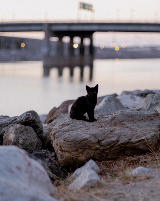
#los angeles river
Text


1938 storms change Los Angeles River
On Feb. 27 and 28, 1938, a storm soaked Southern California with 4.4 inches of rain. Late on March 1, a new, more powerful storm arrived, dropping 10 inches of rain in Los Angeles and more in mountain areas. Rivers overflowed and dozens of people were killed.
Local government agencies responded to the catastrophe by deciding to turn the Los Angeles River into a flood control channel.
6 notes
·
View notes
Text
Los Angeles River
IG: rodrioscr
21 notes
·
View notes
Text


#lavatera#mallow#malva#wildflowers#cereus#cacti and succulents#pepper tree#schinus#palm trees#los angeles river#culvert#los angeles equestrian center#burbank
9 notes
·
View notes
Photo
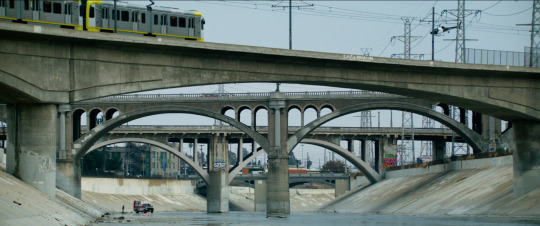
Ambulance (Michael Bay, 2022)
(From foreground to background)
Metro Gold Line Bridge
Los Angeles, California (USA)
Bridge over the Los Angeles river
Type: beam bridge.
&
North Broadway Bridge / Buena Vista Street Bridge
Los Angeles, California (USA)
Bridge over the Los Angeles river
Type: arch bridge.
&
North Spring Street Bridge / Downey Avenue Bridge
Los Angeles, California (USA)
Bridge over the Los Angeles river
Type: arch bridge.
#ambulance#michael bay#2022#metro gold line bridge#metro gold line#los angeles#L.A.#L.A#california#USA#los angeles river#beam bridge#bridge#north broadway bridge#north broadway viaduct#buena vista street bridge#buena vista street viaduct#arch bridge#north spring street bridge#north spring street viaduct#downey avenue bridge#downey avenue viaduct
2 notes
·
View notes
Text


The Los Angeles River, June- July 2022 from my ongoing project The Concrete River
#scenes from the concrete river#los angeles river#la river#documentary photography#color photography
4 notes
·
View notes
Text
After my conversation with a few artists/activists on our mutual obsession with the LA River, I decided to FINALLY begin working on the photobook version of my LA River project, In Search of Alluvium.
STAY TUNED……
You can find the recording of the aforementioned conversation HERE
#artphotography#photography#poetry#visual poetry#la river#los angeles river#bookmaking#photobook#working artist#video art
3 notes
·
View notes
Text
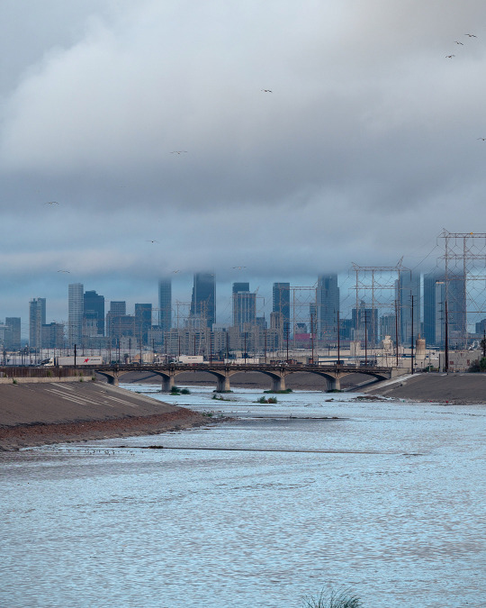
LONG POST: L.A. River. We hate this concrete trough until it saves us from catastrophic flooding.
(LATimes) The unloved L.A. River just prevented a flood disaster. Can more of its water be saved?
By Hayley SmithStaff Writer
As intense atmospheric rivers become more common in a warming world, so too do questions about stormwater capture in Los Angeles. Each year, when rain pours down and the L.A. River roars back to life, Angelenos want to know how much of that water is being captured and stored — and how much is washing out to sea.
The monster storm that hammered Southern California this week dropped billions of gallons of rain, but as much as 80% of that water was whisked into the Pacific Ocean, experts say.
For residents who only recently were asked to conserve unprecedented amounts of water, such a loss can be confounding. But capturing rainfall is only one part of the L.A. River’s job. It is also a flood control channel that is critical to protecting lives and properties when stormwaters surge.
“It’s a delicate balance between capturing that water for beneficial use later on and keeping the public safe — making sure that people can get to work and that children can get to school,” said Kerjon Lee, a spokesman for the Los Angeles County Department of Public Works.
Indeed, without the Los Angeles River and other local channels such as Ballona Creek, more of that stormwater would have ended up in streets and neighborhoods. The waterways were channelized nearly a hundred years ago in response to devastating regional flooding.
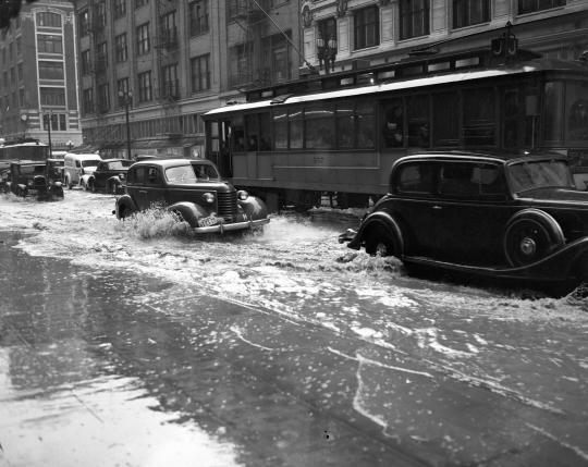
March 2, 1938: Remnants of a destroyed Southern Pacific Railroad bridge are submerged in the roiling waters of the Los Angeles River, in a photo taken from North Figueroa Street.
(Los Angeles Times)
Once a free-flowing waterway, the L.A. River flooded repeatedly as the city was developed. A 1914 flood caused an estimated $10 million worth of damage; the L.A. Times reported that the city was “in the grasp of swirling water.”
On New Year’s Day in 1934, a storm once again unleashed torrents from the San Gabriel Mountains. The river and its tributaries swelled, inundating communities around La Crescenta and claiming dozens of lives and houses.
And in 1938, a great deluge changed the city and its river forever. Engorged by two back-to-back storms, the waterway roared as flows reached the remarkable rate of 99,000 cubic feet per second. Water soon poured into low-lying areas from downtown to Long Beach, sweeping away more than 5,600 structures and killing more than 110 people.
In response to the $78-million catastrophe, the people of Los Angeles called for greater flood control measures, and the U.S. Army Corps of Engineers began encasing the channel in concrete. Experts credited the work with preventing floods in 1969 and 1980, when the river saw even higher flows than it had in 1938.
In that regard, Reznik said, the system “is working as intended.”
March 2, 1938: Drains could not keep up with rain filling streets in downtown Los Angeles.
(Los Angeles Times)
Most of that comes through groundwater recharge, or opportunities for water to spread and seep into aquifers. Public Works also maintains 14 major dams in the mountains above L.A., as well as five others operated in conjunction with the Army Corps. During the summer, water is released from those dams into spreading grounds for percolation.
Subscriber Exclusive Alert
If you're an L.A. Times subscriber, you can sign up to get alerts about early or entirely exclusive content.
You may occasionally receive promotional content from the Los Angeles Times.
The maneuvers are a dance “between flood protection and stormwater capture,” according to Lee. “We want as much capacity as possible in those dams to capture the water and try to hold it up there in the dams for as long as we can, without threatening lives and property downstream.”

The Los Angeles River near downtown.
(Mark Boster / Los Angeles Times)
In 2018, voters approved Measure W, a tax aimed at capturing and cleaning more stormwater before it reaches the ocean. That initiative, later dubbed the Safe Clean Water Program, allocates $280 million annually to stormwater projects, including those geared toward reducing asphalt and hardscaping that prevent water from seeping into the earth.
A report on the program last year found that its progress has been slow, with about 30 acres of green space added across the 3-million-acre county in the first three years.
“Having 90% of runoff heading down the L.A. River isn’t good from a water supply — isn’t good from a pollution, isn’t good from a public safety — standpoint,” Reznik said. “And so I think that’s where we’re going to really have to ask some hard questions about how we can do a better job.”
Los Angeles imports the vast majority of its water from other places, including Northern California, the Owens Valley and the Colorado River. But as drought and warming make those resources less reliable, the need for local supplies has never been more critical, Reznik said.

Stormwater surges from an outfall pipe into the Los Angeles River in Long Beach.
(Don Bartletti / Los Angeles Times)
That’s a problem, because most of California’s water systems were built for “hundred-year” storms, or rain events with a 1% likelihood of occurring, said Anne Lynch, a civil engineer and water management expert with GHD, a consulting firm.
“We’re living off of our grandparents’ investments in our water infrastructure,” she said. “It’s time for us now. We’re all going to have to pay for the future, to address climate change and the degradation of our existing systems as they reach the end of their useful life.”
The good news is that L.A. has the funds to make good investments in stormwater capture, she said.
Measure W includes a variety of efforts to “find ways to incentivize people to put permeable pavers in their driveways and just do different projects all over the L.A. Basin,” Lynch said. “We’re kind of taking it in small snippets, but all of that manages to capture flow, recharge it to the groundwater and also helps with seawater intrusion and a whole host of other things.”
Measure W has seen some success, such as the East Los Angeles Sustainable Median Stormwater Capture Project, which is helping to infiltrate approximately 7.1 million gallons of runoff in the Rio Hondo watershed near Montebello. The project also provides above-ground improvements, such as jogging paths, trees and drought-tolerant landscaping.
County officials said it could take three to five decades for Measure W to reach its goal of capturing 300,000 acre-feet, about 98 billion gallons, of water annually. But during last year’s remarkably wet winter, the county exceeded expectations and captured 628,508 acre-feet, according to Public Works.

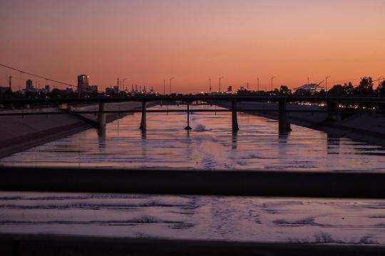
The Los Angeles River flows fast and muddy in February 2023.
(Brian van der Brug / Los Angeles Times)
There are other regional projects underway, including new spreading ground facilities from the Los Angeles Department of Water and Power, “which will all be contributing to the groundwater locally and future drinking-water supply in Los Angeles,” Martin Adams, the general manager, said during a news conference this week.
The Metropolitan Water District of Southern California, a massive regional wholesaler, has also been monitoring flows from the storm, according to spokeswoman Rebecca Kimitch. Although the MWD does not directly manage or store local runoff, its 26 member agencies typically capture about 1.1 million acre-feet of stormwater each year, she said. About 500,000 acre-feet are sent to the ocean.
“On average, about half of that flow to the ocean happens over three days of the year, during large storm events like this,” Kimitch said. “During such storms, the flows are so fast, it can be difficult to capture, and the priority is flood control.”
The latest atmospheric river parked itself over Southern California on Sunday and delivered 60% of L.A.’s average seasonal rainfall in just three days, according to the National Weather Service. Downtown L.A. received a total of 8.51 inches Sunday, Monday and Tuesday — its second-wettest three-day run since official records began in 1877. The highest three-day total was 9.21 inches, during the 1938 flood.
This week’s storm left a trail of chaos, including freeway closures, submerged vehicles, landslides and evacuations. The L.A. River raged; videos show swirling brown water roaring through the channel. On Monday afternoon, the Los Angeles Fire Department rescued a person who was swept away in the river’s rapid waters.
“The banks of the river are not — and I repeat — are not the place to be during the storm,” Chief Kristin Crowley said during a news conference Tuesday. “The L.A. River is full and will continue to flow with high intensity today.”
Yet the river has largely held — absorbing the near-record precipitation from the storm, thanks to extensive preparations, drain clearing and dredging of debris, officials said. Still, some expressed concern that it can be pushed only so far.
“The system can handle multiple atmospheric rivers, as long as they have some spacing between them,” Dena O’Dell, a spokeswoman for the U.S. Army Corps of Engineers, told The Times. “When they are back-to-back without a break, the system could be tested.”
While the county is investing in stormwater capture, such investments are in a race against upstream development that is creating more impermeable areas and increasing flows — not unlike the conditions that led to the floods in the last century.

The Los Angeles River, near Atwater Village, on Monday.
(Ringo Chiu / For The Times)
“It’s a really good sign that we’re not doing things just for one benefit anymore,” she said.
For now, however, there are billions — if not tens of billions — of gallons of runoff that are not recharging aquifers and are continuing to pollute waterways and pose health and safety threats, Reznik said.
If L.A. can continue to reduce storm flows by creating more green space, “it sort of becomes a win for everybody,” he said.
In other words, capturing more stormwater from the L.A. River would have the dual benefit of keeping more people safe and saving them more water.
#refrigerator magnet#los angeles river#los angeles#flooding#floods#rain#el nino#storm#water#that concrete trough we love to hate
1 note
·
View note
Text

"JINX CHANGES HER RACQUET FOR A ROD," Toronto Star. September 11, 1943. Page 32.
---
Because beach locations for "glamour shots" are too far from Hollywood, Columbia studios save gasoline and rubber by making the best of the almost-dry Los Angeles river bed. Jinx Falkenburg, former tennis player and model, poses for this eye-filling shot.
#jinx falkenburg#hollywood#los angeles#los angeles river#glamour shots#supermodel#movie star#tennis player#cheesecake#world war ii
0 notes
Text
Birds horses & pollution
It’s very simple. This was filmed while walking the Los Angeles River. Don’t you love the ducks and prancing horse!
The AQS – that’s the air quality hovered around MODERATE – what is that? Not good
The sound was recorded in Wilmiington / TheNard – a street corner – Anaheim & Nth Henry Dr. intersection. Lots and lots of trucks and a refinery that is not named on MAPS.
The AQS – POLLUTED – what…
View On WordPress
0 notes
Text

PROJECT SITE IN DOWNTOWN LOS ANGELES.....
students are investigating the site and speculating on its future use - developing an URBAN SCENARIO for the site.
_ik
0 notes
Text
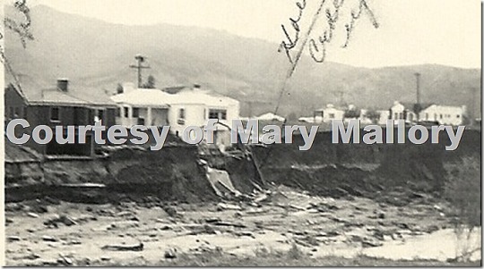
Mary Mallory / Hollywood Heights – 1938 Floods Wreak Havoc on Los Angeles Area
Flooding in North Hollywood, courtesy of Mary Mallory.
Note: This is an encore post from 2013.
Seventy-five years ago, a deluge of rain hit Los Angeles and the surrounding area, leading to massive floods and causing millions of dollars in damage and a devastating loss of life. Many factors led to this destruction: too much rain, inadequate construction of bridges and roads, and homes and…
View On WordPress
0 notes
Text

4 notes
·
View notes
Photo

Ambulance (Michael Bay, 2022)
Fourth Street Bridge / 4th Street Bridge
Los Angeles, California (USA)
Bridge over the Los Angeles river
Type: arch bridge.
#ambulance#michael bay#4th street bridge#fourth street bridge#los angeles#L.A.#L.A#california#USA#los angeles river#arch bridge#bridge
3 notes
·
View notes
Last Seen Blogs

shatterverse-prime
sonic help i'm lost in the void

dwarfmothersden-blog
Dwarfmother's den

cutepoop
Cute Poops

tallenexams
Untitled

ladymacbeth3759
Stranger in a Strange Land