#lotd lighthouseoftheday pharology pharology101 lighthouse lighthouses
Text
LOTD: Esteiro
~sorry for delay - meant for August 2nd, 2023~
(from: https://www.ibiblio.org/lighthouse/prtc.htm)
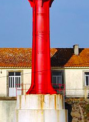
Esteiro (Barra do Sul Range Middle)
1914. Active; focal plane 82 m (269 ft); red light, 4 s on, 2 s off. 15 m (49 ft) square cylindrical masonry tower with lantern and gallery, rising from a square 1-story base. The tower is unpainted except for two red horizontal bands on the seaward side only; lantern painted red. Carlos Alberto Soares da Silva has a photo, José Dias has a 2019 photo, Trabas has a fine photo, and Google has a satellite view. Located in a city park about 760 m (0.47 mi) northeast of the Gibalta lighthouse. Site open (although the station itself is fenced), tower closed. ARLHS POR-019; PT-212; Admiralty D2127.1; NGA 3410.
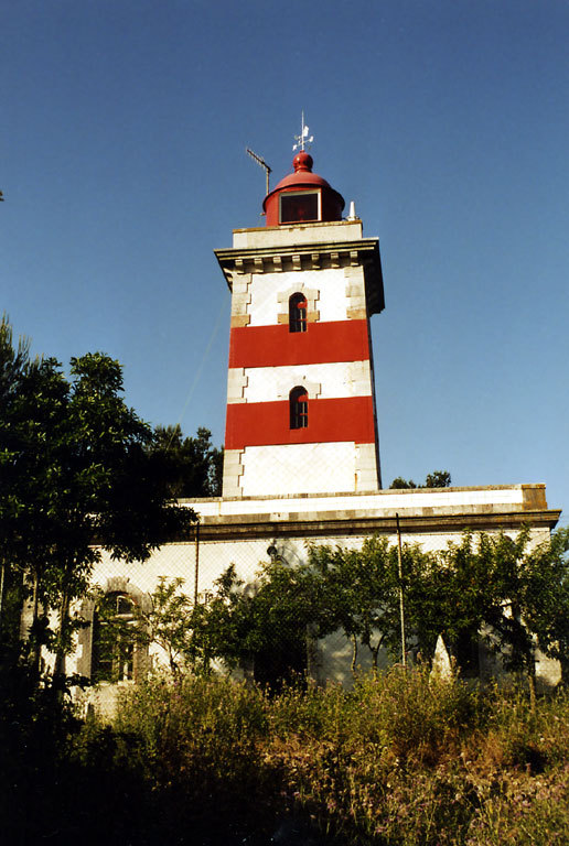
(photo found here;©Trabas)
2 notes
·
View notes
Text
LOTD: Sines West Mole
(from: http://www.ibiblio.org/lighthouse/prtc.htm)
Sines West Mole
Date unknown. Active; focal plane 21 m (69 ft); white flash every 3 s. 8 m (26 ft) round concrete tower painted with red and white horizontal bands. Trabas has José da Palma's photo and Google has a satellite view. Located at the end of the main breakwater of Sines. Site and tower closed. ARLHS POR-099; Admiralty D2160.16; NGA 3583.

(full photo found here; ©José da Palma)
2 notes
·
View notes
Text
LOTD: Los Angeles Harbor
(from: http://www.ibiblio.org/lighthouse/ca2.htm)
Los Angeles Harbor (San Pedro Harbor; Angel's Gate)
1913. Active; focal plane 73 ft (22 m); green flash every 15 s. 69 ft (21 m) cylindrical steel and concrete tower rising from an octagonal concrete base, all on a concrete crib; DCB-24 aerobeacon. Lighthouse painted white with narrow vertical black stripes, lantern and gallery black; concrete base is white. Continuously operating fog horn (2 blasts every 30 s). The original 4th order clamshell Fresnel lens is on display at the Los Angeles Maritime Museum in San Pedro. Trabas has Jim Smith's closeup photo, David Beebe has a 2022 photo, a 2010 photo is available, Shawn Wilson has a 2007 photo, English has a photo, the Coast Guard has a historic photo, Marinas.com has aerial photos, Huelse has a historic postcard view, and Google has a satellite view. This is the only surviving lighthouse of its type. In 2008 members of the Cabrillo Beach Boosters launched an effort to secure grant funds to restore the lighthouse. In May 2010 they hit the jackpot: the Los Angeles Harbor Commission allocated $1.8 million for the restoration. The restoration project began in October 2011 and was completed in May 2012 (the photo at right shows the results). The Boosters hoped to open the lighthouse for tours in 2019 but this has not occurred. Located at the end of the San Pedro Harbor breakwater about 1/2 mile (800 m) east of Point Fermin. Accessible only by boat. Ferries to Santa Catalina pass the lighthouse while departing San Pedro. Site and tower closed. Owner/site manager: U.S. Coast Guard. . ARLHS USA-014; Admiralty G3799; USCG 6-0135 (also 6-3110).
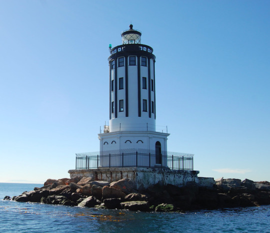
(full photo found here; U.S. Army Corps of Engineers on Flickr)
#lotd lighthouses lighthouseoftheday pharology pharology101#los angeles harbor light#angel's gate#USA
2 notes
·
View notes
Text
LOTD: Alfanzina
(from: http://www.ibiblio.org/lighthouse/prt.htm)
Alfanzina
1920. Active; focal plane 56 m (184 ft); two white flashes every 15 s. 23 m (75 ft) square masonry tower with lantern and gallery, attached to the front of a 1-story keeper's complex. 3rd order Fresnel lens in use. The faces of the tower are covered with white tiles; lantern painted red. A Direção de Faróis photo is below, Larry Myhre has a photo, Rui Ornelas has a photo, Ricardo Santos has a photo of the lighthouse in action, a 2021 photo is available, Trabas has Klaus Kern's photo, Carlos Olmo also has a good photo, and Google has a street view and a satellite view. Located on a rocky promontory off the N530 highway about 15 km (9 mi) southeast of Lagoa. Accessible by road; parking available.Site open, tower open Wednesday afternoons. . ARLHS POR-001; PT-478; Admiralty D2192; NGA 3684.
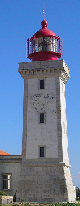
(full photo found here; ©Direção de Faróis)
2 notes
·
View notes
Text
LOTD: Vilamoura Marina East Mole
~sorry for delay - meant for November 30th, 2022~
(from: http://www.ibiblio.org/lighthouse/prt.htm)
Vilamoura Marina East Mole
Date unknown. Active; focal plane 14 m (46 ft); green flash every 4 s. 7 m (23 ft) round bluntly conical tower with gallery, painted with green and white horizontal bands. Trabas has a photo and Google has a street view and a satellite view. Located at the end of the mole on the east side of the entrance to the Vilamoura Marina. Site open, tower closed. ARLHS POR-083; PT-493; Admiralty D2197.4; NGA 3712.

(full photo found here; ©Trabas)
2 notes
·
View notes
Text
LOTD: Lightship Suriname 1
~sorry for delay - meant for October 22nd, 2022~
(from: http://www.ibiblio.org/lighthouse/sur.htm)
Lightship Suriname 1 (Suriname Rivier)
1911 (station established 1858). Decommissioned in 1972. Steel lightship with a round light tower, lantern and gallery. Ship painted red. David Stanley's photo is below, Nicholas Laughlin has a 2009 photo, Vanessa Decort has a 2006 photo, Martijn Baudoin has a 2016 street view, and Google has a satellite view. Michel Forand documented at least five light vessels known to have served the Suriname Rivier station off the entrance to Paramaribo, the national capital. This is believed to be the third. Lightphotos.net has a historic photo of the ship nearing completion in 1910 in the Netherlands. There is another historic photo (2/3 of the way down the page) of the ship, rigged as a sail-driven vessel and with its light tower taken down, leaving the Netherlands for Suriname in 1911. Lightphotos.net also has a photo of the ship on station. In recent years the ship has been righted and partially restored. Located in Fort Nieuw Amsterdam, on the east side of the Suriname River opposite Paramaribo. Site open, and it appears that visitors can walk a plank up on the deck of the vessel. Site manager: Openluchtmuseum Fort Nieuw Amsterdam. ARLHS SUR-004M.
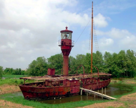
(photo found here; ©David Stanley)
2 notes
·
View notes
Text
LOTD: Mare Island
~sorry for delay - meant for October 21st, 2022~
(from: http://www.ibiblio.org/lighthouse/ca.htm)
Mare Island
(1873-1930s), Carquinez Strait, Vallejo. Anderson also discusses this lighthouse on his Carquinez Strait page. This was another Paul J. Pelz design, similar to the East Brother Island lighthouse. Located at the Mare Island Naval Shipyard, the light was of limited use after the establishment of the Carquinez Strait lighthouse in 1910. It was abandoned and demolished sometime in the 1930s. ARLHS USA-475.

(photo found here; ©US Coast Guard)

(photo found here; no copyright given)
2 notes
·
View notes
Text
LOTD: Cap de Garde
~sorry for delay - meant for October 17th, 2022~
(from: http://www.ibiblio.org/lighthouse/dzae.htm)
Cap de Garde (2)
1884 (station established 1841). Active; focal plane 143 m (469 ft); white flash every 5 s. 14 m (56 ft) square cylindrical stone tower with lantern and gallery, attached to a 2-story stone keeper's house. Kamel Lebtahi's photo is below, Taky Benk has a second photo, a third photo is available, Wikimedia has several photos, Djaber Bouzitoune has a street view of the station, and Google has a satellite view. This is the landfall light for Annaba, located atop a very prominent headland about 9 km (5.5 mi) north of Annaba. Site open, tower probably closed. . ARLHS ALG-012; Admiralty E6506; NGA 22208.

(full photo found here; ©Kamel Lebtahi)
2 notes
·
View notes
Text
LOTD: Esposende (2)
(from: http://www.ibiblio.org/lighthouse/prtn.htm)
Esposende (2)
1922 (station established 1866). Active; focal plane 20 m (66 ft); white flash every 5 s. 15 m (49 ft) round cylindrical cast iron tower with lantern and gallery, standing on a round concrete base. Adjoining 2-story keeper's complex. Entire lighthouse painted red; keeper's house is yellow. Trabas has a good photo, another closeup is available, Marinas.com has aerial photos, and Google has a street view and a satellite view. This is a typical prefabriacted French tourelle. The original light was described as an "iron column." The lighthouse stands in front of the Forte São João Baptista. Located on the north side of the Rio Cavado entrance at Esposende. Site open, tower closed. ARLHS POR-018; PT-031; Admiralty D2016; NGA 3128.
(full photo found here; ©Wikiepedia user HombreDHojalata)
2 notes
·
View notes
Text
LOTD: Leça
~sorry for delay - meant for May 18th, 2022~
(from: http://www.ibiblio.org/lighthouse/prtn.htm)
Leça (Boa Nova)
1926. Active; focal plane 57 m (187 ft); three white flashes every 14 s. 46 m (151 ft) white round reinforced concrete tower with lantern and gallery. Lantern painted red. The surrounding 2-story keeper's complex was used as the school for lighthouse keepers from 1926 to 1962. Trabas has a fine closeup photo by José da Palma, Nuno Filipe Coimbra has a good 2006 photo, Huelse has a historic postcard view, Marinas.com has aerial photos, and Google has a street view and a good satellite view. This lighthouse replaced a smaller lighthouse built in 1916 at Boa Nova, a short distance to the north. Located in Leça da Palmeira, on the north side of Matosinhos, adjacent to a huge petroleum tank farm. Site open, lighthouse open on Wednesday afternoons. . ARLHS POR-029; PT-070; Admiralty D2032; NGA 3236.
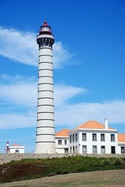
(photo found here; ©Yellow.Cat on Flickr/Wikimedia
2 notes
·
View notes
Text
LOTD: Porto de Leixões Quebra-Mar
(from: http://www.ibiblio.org/lighthouse/prtn.htm)
Porto de Leixões Quebra-Mar
Date unknown. Active; focal plane 24 m (79 ft); red flash every 5 s. Approx. 18 m (59 ft) round concrete tower with gallery but no lantern. The tower is unpainted. Trabas has a good photo and Google has a satellite view. Located at the end of the old north breakwater of the Porto de Leixões, the harbor of the Leça oil terminal. Site and tower closed. ARLHS POR-094; Admiralty D2034; NGA 3240.

(full photo found here; ©Trabas)
2 notes
·
View notes
Text
LOTD: Canal de Chavarria
(from: https://www.ibiblio.org/lighthouse/mxtm.htm)
Canal de Chavarria (Barra Morón) (2)
2012. Active; focal plane 10 m (33 ft); white flash every 5 s. 7 m (23 ft) round cylindrical concrete tower with gallery, painted white with blue trim. No photo available but Google has a satellite view of the station. Located on the north side of a dredged lagoon entrance at Barra Morón. Accessible only by boat. Site open, tower closed. Active light: CF-28-098; Admiralty J4232.5; NGA 15213.
(sorry - no photo available)
0 notes
Text
LOTD: Crabtree Ledge
(from: https://www.lighthousefriends.com/light.asp?ID=1864)
Crabtree Ledge, Maine (Timeline)
1887 – Crabtree Ledge, in Frenchman's Bay, Maine.—This ledge, upon which there are from 8 to 12 feet of water at mean low tide, was surveyed, title to the site, with jurisdiction, was secured from the state of Maine, and drawings, specifications, and estimates for the lighthouse were prepared.
1888 – Crabtree Ledge, Frenchman's Bay, Maine.— On August 4,1886, Congress appropriated $25,000 for the erection of a light-house at this place. The Board designed an appropriate structure for this location and advertised for proposals for furnishing the metal-work and for its erection. The bids received showed that the amount appropriated was insufficient for the erection of the proper structure at this location, and the Board therefore obtained an appropriation of the additional $13,000 necessary for the erection of this light house. The work will now be undertaken at the earliest date practicable.
1889 – Crabtree Ledge, about 1 ½ miles south of Mount Desert Ferry, Maine.— Contracts were made for the metal work, for the cement, and for the erection of the light-house. Part of the metal work and of the cement were delivered at Mount Desert Ferry. The location of the foundation cylinder was fixed upon the ledge, and the building of a crib-pier around it was commenced.
1890 – Crabtree's Ledge, Frenchman's Bay, Maine.—A fifth-order light, January 15, 1890.
1890 – Crabtree's Ledge, between Bar Harbor and Mount Desert Ferry, Frenchman's Bay, Maine.—The light-house recently constructed consists of a cylindrical iron caisson, 25 feet in diameter and 32 feet in height, founded upon a rock 15 feet below mean sea-level. It is filled with concrete and surmounted by an iron tower, 37 feet high from base to focal plane, and was finished December 31, 1889. A fixed white light of the fifth order, varied by a white flash every two minutes, illuminates the whole horizon, and was first exhibited on January 15, 1890.
1891 – Crabtree Ledge, Frenchman Bay, Maine.—A bell struck by machinery, August 1, 1890.
1891 – Crabtree Ledge, between Bar Harbor and Mount Desert Ferry, Frenchman Bay, Maine.—A 1,200-pound bell, struck by machinery, with a bell house of sheet iron, was placed upon the pier. Various minor repairs were made.
1895 – Crabtree Ledge, Frenchman Bay, Maine.—A landing ladder was made and fitted. Various repairs were made.
1903 – Crabtree Ledge, on Crabtree Ledge, Frenchman Bay, Maine.— The color of the tower was changed from brown to white, and the revolving clock and fog-bell machinery repaired.
1913 – J. H. Peasley, keeper, rendered assistance to Arthur L. Bunker in danger of drowning.
1914 – Jerome H. Peasley, keeper, rendered assistance in getting schooner-yacht White Wings off rocks near station.
1916 – J.H. Peasley, keeper, towed disabled motor boat with 1 man on board to shore.
1916 – October 2. Assistant Keeper Chester Brinkworth, 31, and his brother Charles [Arthur Leon], 27 [20], were drowned Saturday near Crabtree Ledge Lighthouse at the entrance to Sullivan Harbor, according to information received here today at the Lighthouse Department. Capt. Sherman went with the lighthouse tender Hibiscus to search for the bodies.
Charles Brinkworth fell from a dory, and his brother sprang overboard to rescue him, both perishing. Jerome C. Peaslee, keeper of the light, was ill, and his assistant, Chester Brinkworth, had gone ashore to bring back his brother as helper. The two were lost on the return trip.
Chester Brinkworth’s body and the capsized dory were found by the Hibiscus, which is searching for the body of Chester’s brother. The latter has left his home at Hancock Point in the face of a heavy wind and high seas. Friends advised against his making the trip, but young Brinkworrh said that, with the keeper in a hospital, his brother would be lonely.
1917 – March 21. Captain Joseph Whitmore, assistant keeper of Crabtree ledge light, was drowned by the capsizing of a boat in which he was returning to his post from Ellsworth, Me.
1933 – Crabtree Ledge Lighthouse discontinued.
1934 – Sold to a group of yachtsmen for $105.
1950 – Crabtree Ledge Lighthouse collapsed during a winter storm.
Keepers:
Head: Amaziah R. Small (1889 – 1898), Charles F. Chester (1898 – 1911), Jerome H. Peasley (1911 – at least 1917), Clarendon G. Hurd (at least 1919 – 1920), Ora S. Jordan (1920 – at least 1921), Thomas H. Morgan (at least 1926 – 1933).
Assistant: Francis T. Hodgkins (1893), Charles F. Chester (1893 – 1898), Joseph M. Gray (1898 – 1900), Rollins E. Dobbin (1900 – 1902), Frederick W. Morong, Jr. (1902), Charles W. Thurston (1902 – 1909), Jerome H. Peasley (1909 – 1911), A. R. Leeman (1911), Frank C. Crowley (1911 – at least 1912), Maurice R. Beal (at least 1913), Chester D. Brinkworth (1914 – 1916), Joseph Whitmore ( – 1917), F.N. Foss (at least 1917), Thomas H. Morgan (at least 1919 – at least 1924), Vassar L. Quimby (1926 – 1933).

(historic photo found from above listed website - actual source unknown)
0 notes
Text
LOTD: Scaramia
(from: https://www.ibiblio.org/lighthouse/sic.htm)
Scaramia (Capo Scalambri, Punta Secca)
Date unknown (station established 1859). Active; focal plane 37 m (121 ft); two long (1.5 s) white flashes every 8 s. 34.5 m (113 ft) round tower with lantern and gallery. Lighthouse painted white; lantern dome is gray metallic. Pippo Palazzolo has posted an excellent photo, Trabas has Arno Siering's closeup photo, Wikimedia has a good photo, Kristina Mihailyus has a 2018 photo, a 2008 photo is available, Marinas.com has aerial photos, and Google has a street view and a satellite view. Located adjacent to the small harbor of Punta Secca, about 25 km (15 mi) southwest of Ragusa and 5 km (3 mi) west of Marina di Ragusa. Site open, tower closed. . ARLHS ITA-042; EF-2942; Admiralty E1896; NGA 10184.
(full photo found here; ©Pippo Palazzolo)
0 notes
Text
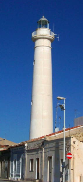
LOTD: Penedo da Saudade
(from: https://www.ibiblio.org/lighthouse/prtc.htm)
Penedo da Saudade
1912. Active; focal plane 55 m (180 ft); two white flashes every 15 s. 32 m (105 ft) square masonry tower with lantern and gallery, attached to a 2-story brick keeper's complex. 3rd order Fresnel lens. Trabas has Meyer's closeup photo, Jose Carlos Gago has a 2021 photo, Noemia Costa Dias has a nice closeup, Marinas.com has aerial photos, Huelse has a historic postcard view, Google has a good street view, and Google has a satellite view. This lighthouse does not mark a prominent cape; it was located at a convenient point halfway between the lights of Cabo Mondego and Ilha Berlenga. The original 3rd order lens was transferred to Cabo Mondego in 1921, but it was replaced by another 3rd order lens of a different type. The lighthouse and keeper's house were both renovated and restored in 1997-98. A penedo is a boulder, in this case a huge rock in the sea in front of the lighthouse. Located directly on the coastal road about 800 m (1/2 mi) north of São Pedro de Moel. Streetside parking is available. Site open, lighthouse open on Wednesday afternoons. . ARLHS POR-034; PT-117; Admiralty D2072; NGA 3312.

(photo found here; ©RomainD.C)
1 note
·
View note
Text
LOTD: Sgat Mòr
(from: https://www.ibiblio.org/lighthouse/sctw.htm)
Sgat Mòr (2)
Date unknown (station established 1923). Active; focal plane 9 m (30 ft); white flash every 3 s. 8 m (26 ft) round cylindrical white steel tower with lantern. This lighthouse marks the east side of the entrance to Loch Fyne from the Sound of Bute. Gordon Brown has a photo, a closeup is available, Trabas has a distant view, Marinas.com has aerial photos, and Google has a satellite view. The body of the lighthouse is a former propane tank, but the light is now solar-powered. Located on a small island off the point of Rubha Stillaig about 3 km (2 mi) south of Portavadie. Accessible only by boat (or sea kayak). Site open, tower closed. Operator: unknown. ARLHS SCO-353; Admiralty A4296; NGA 4276.

(full photo found here; ©Gordon Brown)
0 notes
Last Seen Blogs

themagicforest
The Magic Forest

nothing-personal-baby
How art tho

snapchat-romania
SnapChat Romania Community

miweohae
사랑 참 달콤했어