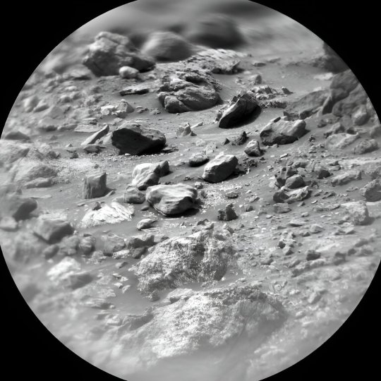
#navcam
Video

flickr
MSL - Sol 3665 - NavLeft da Kevin Gill
Tramite Flickr:
NASA/JPL-Caltech/Kevin M. Gill
0 notes
Text
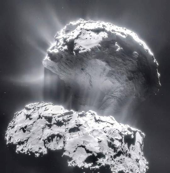
Clearest image ever taken of Comet Rosetta.
ESA / Rosetta / NAVCAM
19 notes
·
View notes
Text

Clearest image ever taken of Comet Rosetta.
ESA / Rosetta / NAVCAM
7 notes
·
View notes
Text

NASA's Perseverance captures dust-filled Martian whirlwind
by Staff Writers
Pasadena CA (JPL) Oct 01, 2023
The six-wheeled geologist spotted the twister as part of an atmospheric exploration of Jezero Crater.
The lower portion of a Martian dust devil was captured moving along the western rim of Mars' Jezero Crater by NASA's Perseverance rover on Aug. 30, 2023, the 899th Martian day, or sol, of the mission. The video, which was sped up 20 times, is composed of 21 frames taken four seconds apart by one of the rover's Navcams.
Much weaker and generally smaller than Earth's tornadoes, dust devils are one of the mechanisms that move and redistribute dust around Mars. Scientists study them to better understand the Martian atmosphere and improve their weather models.
Using data from the imagery, mission scientists determined that this particular dust devil was about 2.5 miles (4 kilometers) away, at a location nicknamed "Thorofare Ridge," and moving east to west at about 12 mph (19 kph). They calculated its width to be about 200 feet (60 meters). And while only the bottom 387 feet (118 meters) of the swirling vortex are visible in the camera frame, the scientists could also estimate its full height.
"We don't see the top of the dust devil, but the shadow it throws gives us a good indication of its height," said Mark Lemmon, a planetary scientist at the Space Science Institute in Boulder, Colorado, and a member of the Perseverance science team. "Most are vertical columns. If this dust devil were configured that way, its shadow would indicate it is about 1.2 miles (2 kilometers) in height."
Dust devils, which occur on Earth as well, form when rising cells of warm air mix with descending columns of cooler air. The Martian versions can grow to be much larger than those found on Earth. And while they are most prominent during the spring and summer months (Mars' northern hemisphere, where Perseverance is located, is currently in summer), scientists can't predict when they'll appear at a specific location. So Perseverance and its fellow NASA Mars rover Curiosity routinely monitor in all directions for them, taking images in black-and-white to reduce the amount of data sent to Earth.
IMAGE....The lower portion of a Martian dust devil was captured by one of the Navcams on NASA's Perseverance rover on Aug. 30, 2023, the 899th Martian day, or sol, of the mission. The video, which has been enhanced in order to show maximal detail, was sped up 20 times and composed of 21 frames taken four seconds apart.
Using data from the imagery, mission scientists determined that the dust devil was about 2.5 miles (4 kilometers) away, at a location nicknamed "Thorofare Ridge," and moving east to west at a clip of about 12 mph (19 kph). They calculated its width to be about 200 feet (60 meters). While only the bottom 387 feet (118 meters) of the swirling vortex are visible in the camera frame, scientists used the dust devil's shadow to estimate its full height at about 1.2 miles (2 kilometers).
18 notes
·
View notes
Text
It was literally just the treads that were throwing me off! (And the mastcams but thats more understandable) looking at the model that is the MSL deck and as stated the navcams, and the wheels are MSL wheels but with perseverance treads (i.e. not chevrons)
#ANYWAY this is only interesting to me and my labmate probably#im also gonna tag this:#not you dd#because she doesn't need to see me nitpicking rover tire treads lmao
2 notes
·
View notes
Photo
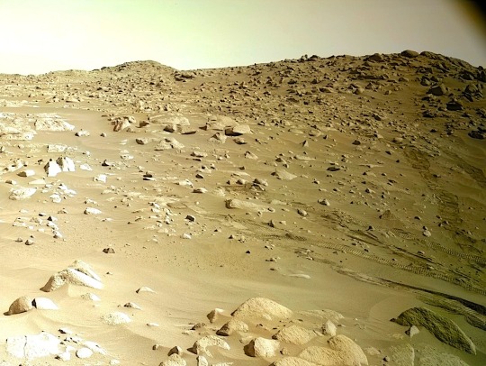
Mount Sharp on the Horizon
Credits: NASA, JPL-Caltech, MSL, Navcam
4 notes
·
View notes
Text
Perseverancia observó otro diablo marciano
La parte inferior de un remolino de polvo marciano fue capturada moviéndose a lo largo del borde occidental del cráter Jezero de Marte por el rover Perseverance de la NASA el 30 de agosto de 2023, el día 899, o sol, marciano de la misión. El vídeo, que fue acelerado 20 veces, se compone de 21 fotogramas tomados con cuatro segundos de diferencia por una de las Navcams del rover.
Mucho más débiles…

View On WordPress
2 notes
·
View notes
Text

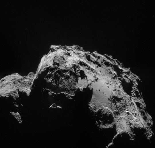
Comet at perihelion
© ESA/Rosetta/NAVCAM – CC BY-SA IGO 3.0
#astronomy#space#esa#european space agency#comet#rosetta#astrophotography#Comet 67P/Churyumov–Gerasimenko
4 notes
·
View notes
Text
Processi deposizionali dell'unità di margine
Un’immagine della geologia marziana sulla strada per Beheive Geyser. Il rover Mars Perseverance della NASA ha acquisito questa immagine utilizzando la sua telecamera di navigazione sinistra (Navcam). La telecamera si trova in alto sul montante del rover e aiuta nella guida. L’immagine è stata acquisita il 19 febbraio 2024 (Sol 1066) all’ora solare media locale di 12:47:59.
L’origine dell’unità…
View On WordPress
0 notes
Link
Pasadena CA (JPL) Feb 13, 2024 Earth planning date: Friday, February 9, 2024: We are found Curiosity at full energy and ready to go this morning. And go we did! We are at a very interesting location with lots of textures in the rocks in front of us, and many features to spot in the walls around us. Geologists feasting time! And feast we did! I counted - between Mastcam, ChemCam, the Navcams, and MARDI almost 450 individ
0 notes
Text
Get this! Curiosity has been on mars for 11 years!!
NASA’s Curiosity Mars rover captured this 360-degree panorama using its black-and-white navigation cameras, or Navcams, at a location where it collected a sample from a rock nicknamed “Sequoia.” The panorama was captured on Oct. 21 and 26, 2023. Credit: NASA/JPL-Caltech
Does that make us invaders or explorers? 

#mars#curiosity#nasa#panoramic#photography#space travel#space#outer space#landscape#alien#alien invasion#space exploration#space invaders#i
0 notes
Text
Perseverance cattura un “diavolo di polvere” su Marte - il video
Il rover della NASA si stava muovendo lungo il margine occidentale del cratere Jezero quando ha ripreso la parte inferiore di un “diavolo di polvere” marziano.
Il video, che è stato accelerato di 20 volte, è composto da 21 fotogrammi ripresi a distanza di quattro secondi l’uno dall’altro da una delle Navcam di Perseverance.
Le immagini sono state scattare il 30 agosto 2023, nel corso dell’899°…
View On WordPress
0 notes
Text
#science#physic#news#technology#space#Astronomy#NASA#Night#Sky#Stars#Space#Science#Universe#Cosmos#Cosmic#Solar System#Milky Way#Bioluminescence#Galaxy#Nebula#Constellations#Constellation#Rainbow#Bright
0 notes
Text
Mars rover continues progress along upper Gediz Vallis ridge
Curiosity continues to make progress along the margin of upper Gediz Vallis ridge, investigating the broken bedrock in our workspace and acquiring images of the ridge deposit as the rover drives south.
Today's 2-sol plan focused on a DRT, contact science, and drive on the first sol, followed by untargeted remote sensing on the second sol. The team had to make some decisions at the start of planning about whether to drive on the first or second sol of this plan, and how that would affect the upcoming weekend activities.
As it turned out, the team was able to fit all of the desired contact science and remote sensing activities on the first sol, in addition to the drive on the first sol, which means we'll be able to downlink more information about our end-of-drive location to better inform planning for the weekend. Weekend plans provide opportunities for a lot of great contact science, so it will be really helpful to have that additional data down for planning.
That means the first sol of this plan is fully loaded! The plan begins with a DRT activity to expose a fresh surface on the bedrock target "Tilden Lake," followed by APXS integrations to investigate its composition. Then the Geology theme group planned several hours of remote sensing activities, including ChemCam LIBS on the bedrock target "Curry Village," which has a similar "dragon scale" texture (or "tire tracks") to what we had observed in the previous workspace.
This big remote sensing block also includes ChemCam long distance RMI mosaics to assess the stratigraphy at Gediz Vallis ridge and the distant butte Kukenan. These long distance RMI images reveal a lot of great detail about distant targets, like the diversity of clasts at Gediz Vallis ridge, as seen in the above image.
The plan also includes a number of Mastcam activities to characterize local textures, sedimentary structures, dark rocks, and sandy aeolian bedforms (known as Transverse Aeolian Ridges, aka TARs) in a nearby trough. The Environmental theme group also planned activities to monitor the movement of fines on the rover deck, search for dust devils, and monitor atmospheric dust.
After this big remote sensing block, Curiosity will use MAHLI to image the contact science target, and then continue driving south. The second sol includes untargeted activities like an autonomously selected ChemCam AEGIS target, additional Navcam deck monitoring, and Navcam line-of-sight observations. After the drive we'll take post drive imaging to prepare for the next plan.
4 notes
·
View notes
Text
신병2 5 화 보는곳 ott
신병2 5 화 보는곳 ott 나왔습니다.
신병2 5 화 볼수있는곳 <
누누 티비 몬 없어도 됩니다.
고화질 바로 볼수 있는 방법 제시 했습니다.
신병 시즌2 보는곳 드라마 ott 무료 보기 알고나면 정말 쉽습니다.


새로 발견된 혜성은 다음 주에 지구를 지나갈 때 가끔 눈에 보일 것입니다. 신병2 5 화 보는곳 ott 그러나 그것을 발견하려면 약간의 노하우가 필요합니다.
EarthSky에 따르면, 일본 우주 사진작가 니시무라 히데오는 지난 8월 초 밤하늘의 사진을 찍다가 니시무라 혜성을 처음으로 관찰했다고 합니다.
그 이후로 천체는 태양 주위를 도는 궤도를 따라 태양계 내부를 통과하면서 밝기가 증가했습니다.
혜성은 화요일에 지구에 가장 가까이 접근해 1억 2,500만 킬로미터(7,800만 마일) 이내로 접근할 예정이며, 이는 향후 5일 동안 잠재적으로 눈에 보일 수 있음을 의미합니다.
SLIM / 달 착륙
일본, X선 위성 '문 스나이퍼' 달착륙선 발사
Hale-Bopp 혜성의 공동 발견자이자 Earthrise Institute의 설립자이자 회장인 Alan Hale에 따르면 9월 17일에 별에서 약 3,400만 킬로미터(2,100만 마일) 이내를 지나 태양에 훨씬 더 가까워질 것이라고 합니다.
니시무라는 약 430~440년마다 하나의 궤도를 완성합니다. “이는 마지막으로 태양 가까이 다가간(그리고 지구에 더 가까이 다가갔을 수도 있는) 때가 망원경이 발명되기 전인 1590년경이었다는 것을 의미합니다.”라고 Paul Chodas 박사는 말했습니다. 캘리포니아 주 패서디나에 있는 제트 추진 연구소의 NASA 지구 근접 물체 연구 센터 소장은 이메일에 이렇게 썼습니다. “당시에는 육안으로 볼 수 있을 만큼 밝아졌는지는 알 수 없습니다.”
그 기간 동안 기록된 혜성은 니시무라와 일치하는 것으로 보이지 않지만, 그것은 꽤 밝아야 볼 수 있다고 헤일은 말했습니다.
니시무라 혜성을 보는 방법
혜성은 거리 때문에 지구에서 볼 수 있을 만큼 거의 밝지 않으며 지평선 가까이로 움직일 것이기 때문에 쌍안경이 그것을 보는 가장 좋은 방법이라고 Chodas는 말했습니다. 그리고 도시의 불빛에서 멀리 떨어진 어두운 하늘은 최적의 시야를 제공합니다.
Sky and Telescope는 하늘을 관찰하는 사람들이 혜성을 발견하는 데 도움이 되는 차트를 신병2 5 화 보는곳 ott 공유했습니다.
로웰 천문대 천문학자 데이브 슐라이처는 "밤하늘에 있는 다른 물체와 혜성을 구별하려 한다면 햇빛이 계속해서 미세 먼지 입자를 밀어내기 때문에 혜성의 꼬리가 항상 태양에서 멀어지는 쪽을 향한다는 점을 명심해야 한다"고 말했다. 애리조나에서.
혜성은 이원자 탄소로 인해 사진에서 녹색으로 보이지만 쌍안경을 통해 보면 활석 가루의 입자보다 작은 먼지 입자에 햇빛이 반사되기 때문에 거의 무색이거나 약간 분홍색으로 보일 것이라고 Schleicher는 말했습니다.
2023년 9월 7일 이탈리아 라퀼라에 있는 혜성 C/2023 P1(니시무라)의 모습. 불과 한 달 전에 발견된 니시무라 혜성은 이번 주말에는 육안으로 볼 수 있을지도 모른다. 계산에 따르면 니시무라 혜성의 공전주기는 약 437년인 것으로 알려졌다. (사진: Manuel Romano/NurPhoto via Getty Images)
니시무라 혜성은 9월 7일 이탈리아 라퀼라 상공 하늘에 희미한 녹색 점으로 보입니다.
북반구에 거주하는 사람들을 위해 Chodas는 아침 황혼이 지기 약 30분 전에 동북동 지평선의 선명한 전망을 찾을 것을 권장합니다. 시간과 날짜를 사용하여 해당 지역에서 아침 황혼(일반 황혼이라고도 함)이 발생하는 시기를 확인할 수 있습니다.
“이번 주 매일 혜성은 태양에 조금 더 가까워지고 있으며, 시간 창은 더 좁아지고, 혜성은 지평선에 신병2 5 화 보는곳 ott 더욱 가까워지고 있습니다.”라고 그는 말했습니다. "이전에 혜성을 관찰한 적이 없다면 이것은 보기 쉬운 혜성이 아닐 것입니다."
혜성이 태양과 지평선에 가까울수록 보기가 더 어려워집니다.
수요일에는 혜성이 지구와 태양 사이를 지나갈 것입니다.
헤일은 “이론적으로는 며칠 안에 저녁 하늘에 접근할 수 있을지 모르지만 여전히 하늘의 태양에 꽤 가까우며 밝은 황혼 속에 묻혀 있을 것”이라고 말했다. "예상보다 상당히 밝아지지 않는 한 눈에 보이지 않을 가능성이 높습니다."
니시무라 혜성의 다음 단계는 무엇입니까
니시무라 혜성이 태양을 얼마나 가까이 지나갈지를 고려하면, 강렬한 열기로 인해 니시무라 혜성이 파괴될 가능성이 있습니다.
“얼어붙은 얼음이 가열되어 가스로 승화되면서 혜성은 부서질 수 있습니다.”라고 Chodas는 말했습니다. "그것은 가스와 먼지로 구성된 대기인 '혼수상태'에 둘러싸여 있기 때문에 우리가 알지 못하는 핵의 크기에 따라 많이 달라집니다."
그러나 혜성이 이전에 적어도 한 번의 태양 근접 접근에서 살아남았고, 아마도 신병2 5 화 보는곳 ott 더 많은 혜성(혜성의 나이는 알려지지 않았지만)에서 살아남았다는 점을 감안할 때 헤일과 다른 전문가들은 혜성이 살아남을 것으로 기대하고 있습니다.
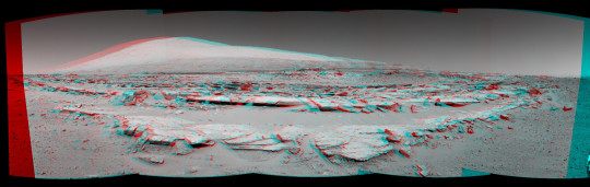
애너글리프(Anaglyph)는 스테레오 또는 다중 뷰 이미지를 통해 물체나 지형을 3차원으로 간단하게 시각화한 것입니다.
여기에 제시된 애너글리프는 Pragyan Rover에서 캡처한 왼쪽 및 오른쪽 이미지로 구성된 NavCam 스테레오 이미지를 사용하여 생성되었습니다.
이 3채널 이미지에서 왼쪽 이미지는 빨간색 채널에 배치되고 오른쪽 이미지는 신병2 5 화 보는곳 ott 파란색 및 녹색 채널에 배치됩니다(청록색 생성). 두 이미지의 원근감 차이로 인해 스테레오 효과가 나타나 입체적인 시각적 느낌을 줍니다.
3D로 시청하려면 빨간색 및 청록색 안경을 권장합니다.
1 note
·
View note
Last Seen Blogs

zeevsglife
Zee VSG Life

bubbleschwagg14-blog
#YOLO

midnight-manga
Midnight's Blog

darkhorizonapparel-blog
DARK HORIZON APPAREL

clydetsuang
running out of time.