#speculative geography
Text
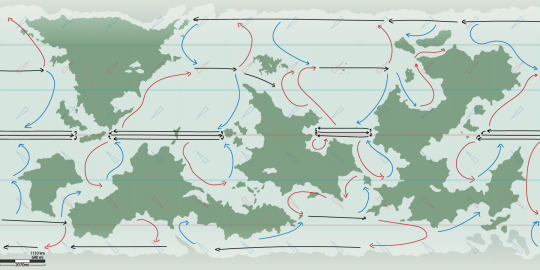
On of the biggest individual aspects of my worldbuilding endeavors thus far has been getting to this point with my world map. I have gotten here, and past it, several times now leading up to this moment, but I think I am finally happy with it.
What you see is the landmasses and general projection of the ocean currents. These currents help predict many things about a planet's climate and weather, and therefore are the first step towards my main goal of projecting climate zones in line with the Köppen climate classification.
I would love to eventually write up a guide on how to get here, as well as my next steps, but the gist of what is to come is that the red arrows represent "warm" currents (moving equatorial waters pole-ward) and blue represent "cold" currents (polar waters equator-ward). These, combined with the low and high pressure zones created by wind, contribute directly to precipitation and general air temperature, as well as obviously the relative temps of the coastal waters.
21 notes
·
View notes
Photo

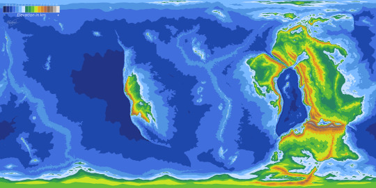
I'm trying to experiment with drawing maps, and to start here is the 2.0 map of the (currently unnamed) world of my Midnightverse project! It's a future Earth so I traced over Earth's geography and adjusted as I pleased. I plan on adding biomes, nations, etc. later
7 notes
·
View notes
Text
something I don’t see people bring up a lot when talking about worldbuilding, especially when you’re creating cities, is wind. prevailing winds in many places in the northern hemisphere blow from west -> east, and because industrial production tended to take place in the centre of cities, workers would live downwind of factories while the wealthier classes would live on the other side, away from air pollutants, which is why a lot of cities have a poor east-end and a rich west-end, a spatial configuration that persists in many places that are now post-industrial
and in general the built environment has a durability to it that persists far past the historical moments that produce those configurations. this means that the stated aims of a city via a vis city planning are frequently at odds with the physical layout of the city itself. so if you want to create a city that feels like it has a long history to it, working through its earlier stages of production can help with decisions you make about its layout, and also allow for weird spatial contradictions in a city that has to constantly fight against its own physical history
#geography#note hell#this works for non industrial cities also you just need to modify it#like a lack of industrial standardisation probably also means roads are not standardised#etc#I don’t know very much about city layouts in pre-industrial history#so on my part it would be more speculative
7K notes
·
View notes
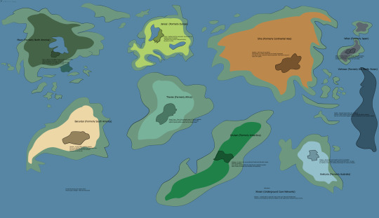
Text
After over 70 hours and 6 months of work, the Topographic Map for Jom'Gol is completed. I present to you the proper elevation map of Jom'Gol complete with tectonics, orogeny, land topography, and oceanic topography. (Legend in top left corner)
2 Billion years of continental tectonic work to achieve this. A lot of sweat, calculations, and tears were put into the final result, and now I can finally move on with the rest of my progress (ocean currents, biomes, air cells, etc).
Some points of particular interest on this map:
The oceanic basin in the center of all the continents is a very ancient ocean that is only now being converged on by the surrounding continental plates. The oceanic plate is submerged under them as they converge, creating deep trenches on the plate boundaries.
As the plates move inward and collide, a massive Himalayan mountain range forms, larger than North America in width (East-West), and towering many kilometers into the sky.
The lone continent drifting in the sea west of the converging supercontinent, although it may not look very sizable, is larger than the African continent on Earth (North-South). Its isolation from the rest lends it to not only one of the most unique biospheres on the planet but also the deepest trench on Jom'Gol to the west of its converging boundary.
More work from the Jom'Gol Project coming soon!
#art#digital art#artists on tumblr#worldbuilding#speculative evolution#speculative biology#spec bio#spec evo#jomgol#plate tectonics#topography#geography#speculative worldbuilding#maps#mapmaking#planets#ocean
31 notes
·
View notes
Text
My favorite part is saying "what if there was a guy" and then killing him
#world building#polls#fantasy#sci fi#geography#speculative ecology#fantasy ecology#mythology#conlang#magic system
71 notes
·
View notes
Text
Idle thought: Thedas is like the Bermuda Triangle stories.
With stormy and nearly impossible to traverse seas to the north and east. The Amaranthine Ocean swallowing any who dare to sail too far out, the northern sea consuming many vessels the Qunari send back to their homeland.
But to the west? A lone ocean that allows one group to leave and return again and again to trade with the Anderfels. Seemingly dwarven sailors hailing from lands without lyrium and where only a great disaster in their lands prevented them from their regular trade. The west is also where the continent continues beyond where we can see.
The Donarks are an impassable, hard to navigate jungle that continues north. The south is the Sunlesslands, so cold the Chasind exile people to it.
But what if the seas are safer than they were previously? If they had been so impossible to sail through, that humans, kossith, were only just barely able to venture south and westward? That the dwarven sailors were only able to sail in from the west safely after the veil was put up. That the seas calmed just enough to allow the first humans, the Neromenians to land on the northern shores and the kossith to land on the eastern shores of Ferelden and into the Korcari Wilds. If it was only after the veil that the Volca sea calmed enough to be safe to travel consistently.
What if, after the kossith landed, they didn't disappear because of the Blight that hadn't reached the surface yet, but because Tevinter captured them. Turned them into Qunari, until eventually Kosslun was the only one who survived the departure of Tevinter. One of the few who made it to the northern lands where they made their home and established the Qun despite the stormy northern seas. But later, his people returned south, braving those same storms. The storms allowing you to come in but to rarely ever leave.
#dragon age#idle thoughts#veil theory#thought I queued this but apparently just shoved it in the drafts#I've been thinking about it as I look at and speculate Thedas's geography and where they might fall on the hadley cells.#Then just ran with the general idea of how the Kossith ended up in Thedas#How the Qunari came to call the north beyond the Boeric Ocean their homeland when we know that Tevinter created them.#Archi is musing
8 notes
·
View notes
Text
So bit I noticed, but I think most people missed, at least if you're not familiar with The geography of Los Angeles county.

Anne at the end of the series, works in the "Aquarium of the pacific", a real world aquarium located in Long Beach City, south of Los Angeles.
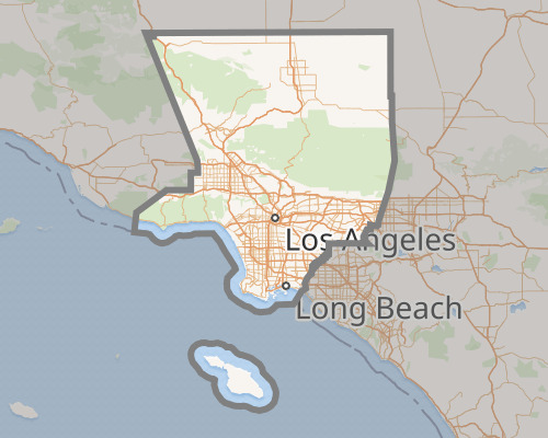
Which in turn in turn means that Anne and Sasha haven't just reconciled at this point.
They seem to be living in the same city, both of them having left behind Los Angeles.

Both of them, when they were done with college, out of everywhere they might have gone, just so happened to choose Long Beach city.
For Anne it makes perfect sense. After all, her's is a job that forces her to seek out a place that's already established. And the aquarium of the Pacific is a perfect place to work at.
But Sasha?
As a Psychiatrists, Sasha would be much, much better off working in one of the U.S.A's bigger cities.
Instead she choose Long Beach, a city that doesn't even have half a million people.
466,742 isn't a small number, but by U.S.A's standards it's not that big either.
Out of everywhere she could possibly have moved, she choose here.
Like... I'm not saying this is absolutely impossible otherwise, but the more I look at this series, the more I'm starting to think my theory that this series was supposed to end with a Sashanne ending isn't as strange as I thought it was.
Because if so, it would make perfect sense why, out of everywhere in the entire country that Sasha could have chosen to settle down once she got her degree, she just so happened to choose the one city where Anne was.
#amphibia#anne boonchuy#sasha waybright#los angeles#long beach#aquarium of the pacific#sashanne#speculation#meta#geography
179 notes
·
View notes
Text
I have made a map of the erythran continents
#erythra#speculative biology#speculative evolution#spec evo#erythra art#planet#alien planet#alien planet map#alien geography
2 notes
·
View notes
Text
i just realized y'all don't know me well enough to know my habit of taking extensive notes for anything i read/watch and making custom excel spreadsheets for funsies
#if i was 12 id be filling up journals but im an adult so now i have...i have so many Documents...Help...#as an example: before TCF had an Official Map. i reread the whole thing in order to take EXTENSIVE notes on geography#(both large scale and local)#and was going to make a map myself#i had a (very. VERY.) rough draft for the map itself that i lost when i restarted/cleaned up my computer last year#but i remember the official map came out before i could complete mine and i was RIGHT ABOUT LIKE. LITERALLY ALL OF IT#(and also spotted a typo or mistranslation because of it im pretty sure. they put southwest when they meant southeast for something)#another example is the 400 page joongdok google doc#also my custom auto calculating ttrpg character sheets#my extensive minecraft storage system spreadsheets#i have docs that are jsut stream of consciousness that i word vomit into as i read then go back and organize afterwards#etc#i also keep docs for loved ones and what they like/dont like/etc#(ive mentioned before but i have very bad memory so keeping records is how i show i care about someone/thing)#anyways me [handshake] kdj: filling up pages upon pages analyzing and speculating on our favorite things#ky speaks
15 notes
·
View notes
Text
anyway just to speculatively expand on the five new rivers forming the Sea of the Castout:
Due North: direction of the Storm Spire—Sky
Northeast: direction of Umber Tor—Earth
Northwest: direction of the Moonstone Path, where Sol Regem hangs out—Sun
Southeast: basically open ocean???—Ocean
Southwest: direction of Elarion and the Gulf of Tenebris—Moon???
Now, I’m mostly thinking of this in terms of arranging the Archdragons to surround the trap/prison, but another possible source is the primal nexuses. We have the Sky and Earth nexuses, and if you kind of squint, the northwest river could be aimed at the Moon nexus. I wouldn’t be surprised if the whirlpool of the Spinning Sea is the Ocean nexus (though it also may not be, we have no indication of whether or not it was there before the border was formed), but unfortunately that leaves southeast for Sun and there’s just… nothing down there. Or if the Ocean nexus is a point in the southeast, I guess you could extreme tinfoil hat that Elarion was built on the Sun nexus, but I find that… pretty dang unlikely to have been a thing the elves allowed to happen.
(And yes, the wiki casually claims the Sunforge was the Sun nexus but a) source please, and b) we’re given every indication that the nexuses are naturally occurring, not constructed/grown, so no it wasn’t.)
7 notes
·
View notes
Text
MAYA 1b:
North Pole
Heres a map of the North pole/northern supercontinent (or what remains free of the ice actually) where the Artiopods evolved

The specifics might be subject to change but I'm happy with it as of rn
2 notes
·
View notes
Text
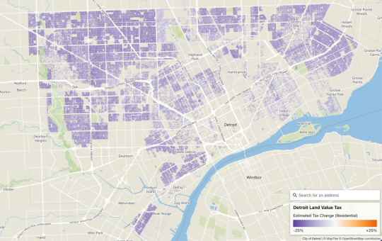
Detroit Land Value Tax Map 2023
by: Pat Sier
With Mayor Duggan’s split value land tax proposal currently stalled in the state legislature, both advocates and opponents have raised questions about what the plan would mean in practice for Detroit taxpayers.
At a recent charter-mandated meeting, the mayor’s office previewed a tool for anyone to receive an estimate of how property taxes for their address would change under the…
View On WordPress
#2024#cartography#data#Detroit#geography#land#land value#land value tax#map#Pat Sier#speculation#tax#taxation
0 notes
Photo
And now for a new iteration of the Midnightverse map, featuring a small sampler of the nations present! Notably I mostly wanted to avoid out-and out fantasy ethnostates even if some places have a large population of such and such species.
(...excepting the Frog Council)
4 notes
·
View notes
Text
Alternate US
#alternate future#alternate universe#countries#form#future#geography#help#help help help#poll#alternate us#usa#US#speculative#survey#quiz#san diego#los angeles#phoenix#socal#southern california#california#arizona#nevada#capital#capital city#country
0 notes
Text
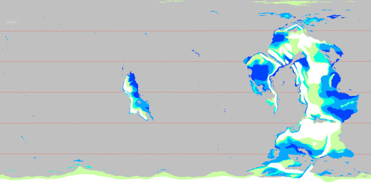

Updated my precipitation maps !!! (Summer N. Hemisphere on top, Winter N. Hemisphere on bottom)
If you are curious to what I have updated, I forgot important parts of my calculations. While I certainly DID factor in my axial tilt, I did not realize how insane some physics get past 35 degrees axial tilt, and mine is at 40. So basically, the world is MUCH wetter than previously thought.
Dark blue still represents extremely wet, Blue still represents wet
Cyan represents marginally wet, or areas that are typically wet "subtropical"
The pale green now represents Wet Semiarid, something not uncommon on Earth, but something that works entirely different on Jom'Gol. They remain essentially deserts throughout a significant amount of the year. During intermediary seasons (spring and fall), an interesting heating of the oceans results in MASSIVE rainfall to these areas.
These deserts, which have been dry as bone for half the year, suddenly receive up to 6 feet of rain, a decent rainforest amount and certainly not dry. Due to the strange nature of these areas, they have been given their own type of region that for now just represents "Wet Semi-arid".
(Another note about the tilt of the planet makes it so that even the most arid of deserts still receive up to 70-90 cm of rain per year {{2.5 feet}} !! )
#digital art#art#artists on tumblr#worldbuilding#speculative biology#speculative evolution#spec bio#spec evo#jomgol#oceanography#cartography#mapmaking#precipitation#speculative worldbuilding#geography
13 notes
·
View notes
Text
A post of mine from several months ago about the Perlesvaus self-rearranging forest just wandered across my dash again and made me think about it some more, so I wanted to talk about it a bit.
Perlesvaus, for those who don’t know, is a 13th-century French Arthurian romance. It’s intended to be a continuation of Chretien de Troyes’s Perceval, but it’s mostly known for being completely batshit when it’s known at all. (There’s an old book on Arthurian texts that dedicates a chapter to Perlesvaus and repeatedly speculates that the anonymous author had Something Wrong With Him. This is the longest scholarly treatment of Perlesvaus I’ve been able to find & read.)
Anyway, there’s an odd worldbuilding detail in the text. See, it’s a Thing in chivalric romances that the questing knights happen upon castles & lords & damsels & such that are unfamiliar to them and have to be explained. You know, “this is the Castle of Such-and-Such, where the local custom is as follows. It’s ruled by Lady So-and-So, whose character I shall now describe to you.”
This is a genre convention that largely goes unquestioned, but it’s a bit odd if you think about it. All these knights are at least minor nobility. They don’t know the other nobles in their region? They don’t know what castles are where? Don’t they have, like, diplomatic relations with these people or at least attend the same tournaments? Even if they’re all fully committed to the knight-errant lifestyle and don’t really engage in courtly diplomacy, you’d think they would share information with each other and get the lay of the land. But instead, to use TTRPG terminology, it’s like they’re all on a hexcrawl that was randomly generated just for them to have these adventures.
The author of Perlesvaus decides to address this. In what’s kind of a throwaway paragraph late in the text, he explains that God moves things around so knights always have new quests to do (and, presumably, is also making sure they always arrive at the right narratively-significant moment). So the reason they’re always encountering people & places they have no knowledge of is because those people & places really weren’t there yesterday. They didn’t know about the Castle of Such-and-Such because it’s normally a thousand miles away and the forest path they followed to get there used to lead somewhere else.
And I think that would be a really interesting thing to stick into a novel or a TTRPG or something. When a knight rides into the forest with the intent of Going On A Quest, at some point they go around a bend in the path, cross an invisible barrier, and wind up in the Forest of Narrative. This is a vast forest with no set geography, filled with winding paths and populated almost entirely with questing knights, damsels in search of questing knights, friendly hermits, strange creatures, and allegorical set-pieces. Then, at the narratively-appropriate time, they cross back over the invisible barrier back into the regular world, and find themselves wherever the Narrative has decided they need to be. This could be a different country, a different continent, or a different world entirely.
Whether anyone involved is actually aware that this is how it works is… optional, really. Though if it’s not a Known Phenomenon, the people whose jobs it is to handle trade & diplomacy & god forbid, maps, are going to end up tearing their hair out in frustration.
2K notes
·
View notes
Last Seen Blogs