#suncalc
Text
Mannen opgepakt voor projecteren racistische leuzen
De politie heeft twee mannen (34 en 24, uit Landgraaf en Zwijndrecht) aangehouden die mogelijk betrokken zijn bij recente projecties van discriminerende en racistische leuzen op gebouwen en bruggen. In woningen van de mannen zijn onder meer een kruisboog en 3D-geprinte wapenonderdelen gevonden plus uiteraard meerdere gegevensdragers. In filmpjes op Telegram liet de Nederlandse tak van het…
View On WordPress
0 notes
Text
Unwrapping the Wonka Bar Vol. 1 - Where is Charlie’s Town Located? Part 10
If you haven’t read the previous post, click here for Part 9 to make sure you are caught up to speed. If you’re already read the previous posts, then welcome back and let’s get back to the show!
Exhibit #8: Just Where in London is Charlie's Town Located?
Up to this point so far, we have established that Charlie's town is somewhere on the edge of the Greater London region, more specifically, East London as the map in the local newspaper focuses on the coastline of neighboring County Essex.

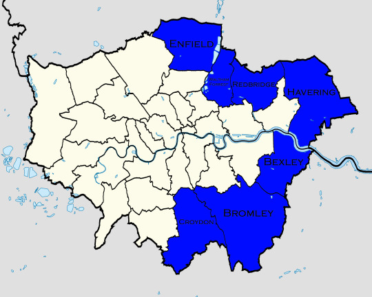
Now, the Greater London region is divided into 32 boroughs and the independent City of London, and when we combine that information with what we already have, we can narrow the search for the location of Charlie's town down to seven boroughs: Enfield, Waltham Forrest, Redbridge, Havering, Bexley, Bromley and Croydon.
But this still does not tell us exactly where in London Charlie's town is located. Therefore, in order for us to do just that, it's going to take us conducting yet another ridiculously hyperfocused analysis of a children's movie in order to get a definite answer that is totally not what the filmmakers had in mind when making the film...but still.
Now, when it comes to narrowing the field down even more, we are going to need to know what direction Charlie's town is facing and in order to do that we are going to need to analyze the position of the sun and the direction shadows are pointing towards.
And yes, this quickly turned into yet another installment marking the transformation of this volume from a fun little post from a fan to a Masters thesis in a university socio-geography program.
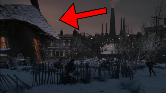
After looking through the film, I was able to point out 31 different shadows that we shall be using as the data set for our analysis, and to get to the point sooner, I will reveal to you all right now that 29 of the 31 shadows shown on screen point in the direction of the Bucket home and the unurbanized land that lies beyond it.
Now, when we combine this information with what we know scientifically about what direction shadows point towards in the northern hemisphere during the winter months, we can see that the Bucket home is on the northern edge of town.
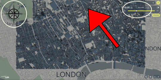
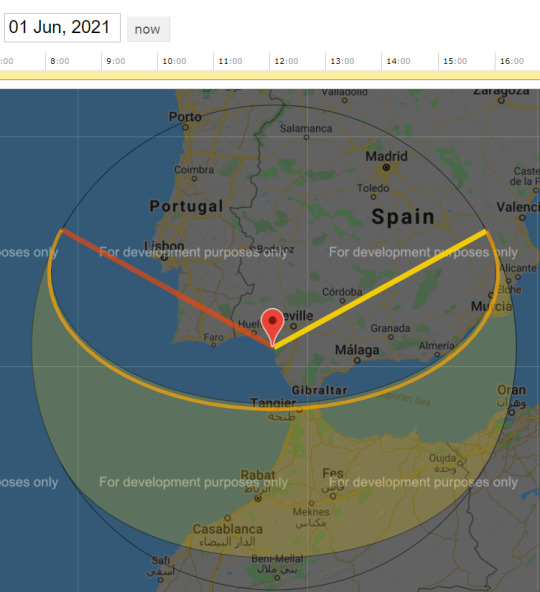
As you can see in this screenshot from Shadowmap, a company that maps out in what direction the sun faces and shadows are cast to help companies plan out how they want to lay out their buildings, shadows point northwest during the morning, like at 10 AM, during the winter months in London. The reason for this is being that the sun, for all intents and purposes, is to the south of London, with the Earth's equator in that direction, meaning the sun will be closer to the southern portion of any location rather than the northern portion.
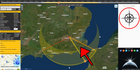
And, as can be seen in this screenshot from Suncalc, a website that allows users to see how long the sun was out on any particular day anywhere in the world, the sun was to the south of London, specifically to the southeast, at 10 AM on Tuesday, February 1st, 2005, the time, day and date of the Golden Ticket winner's tour of Willy Wonka's Chocolate Factory.
Now, with the sun to the southeast of London in the morning, this means that shadows will point in the opposite direction, in this case the northwest, which lines up exactly with what we saw on the Shadowmap screenshot. Additionally, as the sun sets in the west, this means that shadows will point towards the northeast in the evening. This will be an important fact to remember as not every scene with a shadow takes place during the morning hours.
And so, without further ado, I present to you yet another ridiculous analysis that in no way actually guided the filmmakers who made this movie:

First off, the shadows of the customers outside Willy Wonka's first store on Cherry Street point towards the northeast, meaning this takes place during the afternoon.
Sidebar #10.1: We know the shadows are pointing towards the northeast because the store is on the corner of Cherry Street and First Street, and since we know that the Bucket's home is located at the end of First Street, with Cherry Street closer to the Bucket home than the Factory, we can assign these shadows such a designation.

The shadows of Willy Wonka's Chocolate Factory on opening day point towards the northwest, meaning this takes place during the morning.
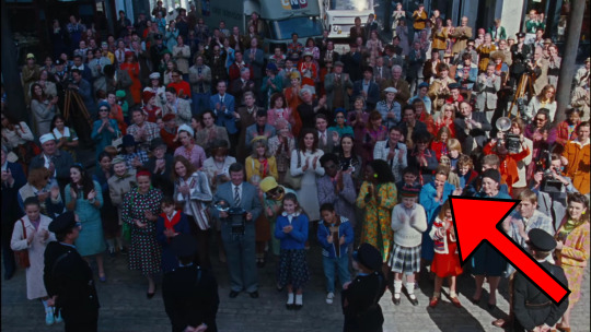
The shadows of the police officers and the news reporters at the opening ceremony of Willy Wonka's Chocolate Factory point towards the northwest, which fits with the event's previous designation as taking place in the morning.
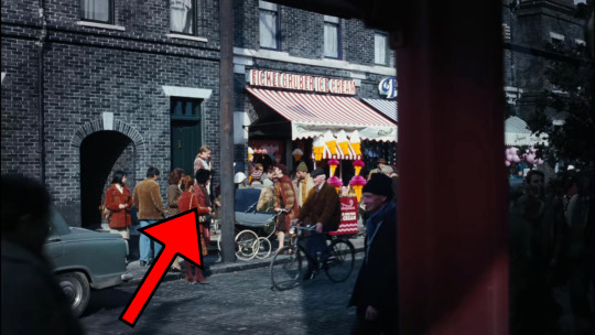
The shadows of pedestrians and a telephone pole while the other candymakers sell their knock-off candies on Cherry Street point towards the northeast, meaning this takes place during the afternoon.
Sidebar #10.2: Because we have established that Cherry Street is closer to the Bucket home than Willy Wonka's Chocolate Factory, and the fact that the shadows point away from Willy Wonka's first store in a perpendicular direction, similar to the direction of First Street, we can assign these shadows with such a designation.

The sun, which is setting while Willy Wonka announces to his employees that he is closing his factory forever after so many cases of corporate espionage rock his business, is setting in the west, meaning this takes place during the afternoon.
The shadows of the ladder leading up to Charlie's bedroom in the attic crawlspace and shelves up against the northern wall of the Bucket home point towards the northeast, meaning this takes place during the afternoon.
Sidebar #10.3: The wall of the Bucket home where their fireplace is built into is closer to Willy Wonka’s Chocolate Factory than the wall in question, meaning this wall is facing the empty field beyond the borders of Burtonville, or in other words, to the north, which is why we can assign these shadows such a designation.
The shadows of the people walking on the sidewalk parallel to Factory Street while Charlie fishes out a used newspaper from the trashcan point towards the northeast, meaning this takes place during the afternoon.
The sun, which is setting while Charlie runs back home with his Golden Ticket, is setting on the east, which is scientifically inaccurate.
Sidebar #10.4: There are a few shadows, or in this case sunsets, in the film which do not line up with how shadows and sunsets work. However, this one in particular can be explained away by the fact that the sunset is CGI and obviously the result of negligence from the post-production team and the fact that this whole direction of shadows thing is something we're only discovering a pattern for after the fact.
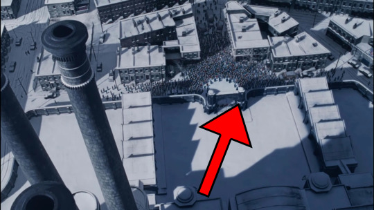
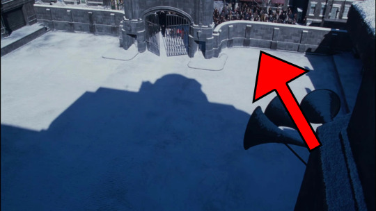
The shadows of the factory and other buildings while the Golden Ticket winners and their guardians wait for the front gates to open at 10 AM point towards the northeast, which is scientifically inaccurate.
Sidebar #10.5: This is another case of the discrepancy being caused by the fact this scene is clearly CGI and the post-production team had no direction when it came to what direction the shadows should point towards.
The shadow of one of the loading docks at 10 AM points towards the northeast, which is scientifically inaccurate.
Sidebar #10.6: This and the following scientifically inaccurate shadows are the result of inaccurate lighting caused by the fact that the cinematography crew were not given the insight into where in the world Charlie's town was located, and thus did not have the proper knowledge to position the lighting in a way to align with how the real world operates.
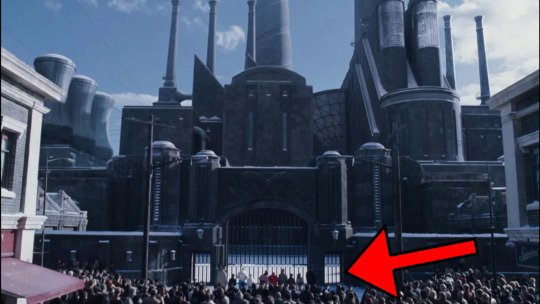
The shadows of the police barricade blocking the crowd from getting too close to the factory at 10 AM point towards the northwest, confirming this takes place during the morning.

The shadow of the front gate as it opens at 10 AM points towards the northwest, confirming this takes place during the morning.
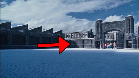
The shadows of the factory corridor entrance building and of one of the loading docks on the factory yard while the gates open at 10 AM point towards the northwest, confirming this takes place during the morning.

The shadows of one of the loading docks and of the factory corridor entrance building on the factory yard while the gates open at 10 AM seen from a different angle point towards the northeast, which is scientifically inaccurate.
Sidebar #10.7: The shadows cast by the various buildings comprising Willy Wonka's Chocolate Factory shift from scientifically accurate to scientifically inaccurate a lot during the opening of the gates scene. In fact, the easiest way to see this without having to pause the film is by paying close attention to the last two scenes, which play right after the other in the film, and comparing how the shadows invert.

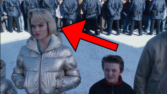
The shadows of the police barricade blocking the crowd from getting too close to the factory at 10 AM point towards the northeast, which is scientifically inaccurate.
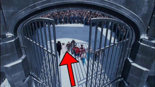
The shadows of the opening gates while the Golden Ticket winners rush inside the factory yard and the the police barricade blocking the crowd from getting too close to the factory at 10 AM point towards the northwest, confirming this takes place during the morning.

The shadows of the Golden Ticket winners and their guardian as they enter the factory yard and the front gates at 10 AM point towards the northeast, which is scientifically inaccurate.

The shadows of one of the loading docks and of the factory corridor entrance building on the factory yard while the Golden Ticket winners and their guardians pass the gates at 10 AM point towards the northeast, which is scientifically inaccurate.

The shadows of the factory corridor entrance building and of one of the loading docks on the factory yard while the Golden Ticket winners and their guardians stand in line on the other side of the gate at 10 AM point towards the northwest, confirming this takes place during the morning.
The shadows of the factory corridor entrance building and of one of the loading docks on the factory yard while the Golden Ticket winners and their guardians stand in line on the other side of the gate at 10 AM visible from the ground level point towards the northeast, which is scientifically inaccurate.

The shadows of the Golden Ticket winners and their guardians as they walk towards the entrance to the doors of the factory corridor entrance building at 10 AM point towards the northwest, confirming this takes place during the morning.

The shadows of the front gates and of the Golden Ticket winners and their guardians as the gates close behind them at 10 AM point towards the northeast, which is scientifically inaccurate.

The shadow of the factory corridor entrance building as the front gate finally closes at 10 AM points toward the northwest, confirming this takes place during the morning.

The sun, which is rising while the Golden Ticket winners and their guardians approach the doors of the factory corridor entrance building and its rays reflect on the windows of a tower with a smokestack above at 10 AM, is rising from the west, which is scientifically inaccurate.
Sidebar #10.8: This is the other example of a discrepancy caused by post-production negligence as this shot of the face of the factory, as well as other details like the rising sun and its rays are clearly CGI.

The shadows of the central buildings of Willy Wonka's Chocolate Factory as the Golden Ticket winners and their guardians reach the doors of the factory corridor entrance building at 10 AM point north, which is scientifically inaccurate.
Sidebar #10.9: While it appears this example could be evidence that the northern Bucket home hypothesis is incorrect, this and the previous example prove that the sun is behind the factory, meaning that it is to the south of the Bucket home and the empty rural lands beyond the limits of Burtonville. This fact, and the fact that the factory yard is always covered by some sort of shadow indicates that the face of the factory faces north as London is in the northern hemisphere and shadows in the northern hemisphere always point north.
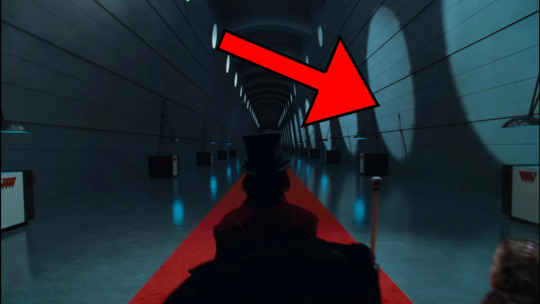
The light reflecting through the windows that run along the eastern wall of the factory corridor entrance building at 10 AM reflects onto the western wall, confirming this takes place during the morning.

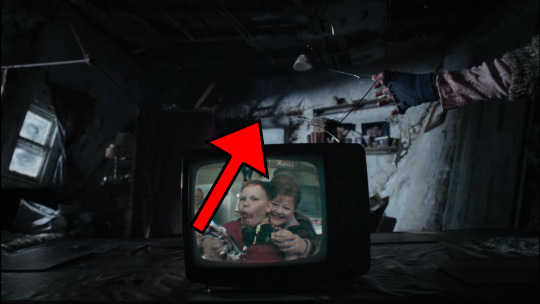
The shadows of the rubble from the roof that was damaged by the Great Glass Elevator crashing through and those of Charlie, his parents and Grandpa Joe point towards the southeast, which is not just scientifically inaccurate, but also incompatible with the northern Bucket home hypothesis.

The shadows Grandpa Joe's body and the broom he wields cast as he sweeps the floor of the Bucket home on February 2nd point towards the northwest, meaning this takes place during the morning.
Sidebar #10.10: February 2nd, 2005 fell on a Wednesday, meaning that Charlie should be in school and not at home helping his parents fix the hole in the roof (or at least picking up pieces of what I assume is wood from the front yard).
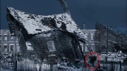
It makes sense that Charlie would get his parents permission to miss school on Tuesday, February 1st for the tour, but why did let him ditch class on Wednesday, February 2nd? Ultimately, this is just another oversight of the creators of this film who prioritized trying to craft an emotionally impactful scene over the realities of life. That, or perhaps there’s a secret clause in the Golden Tickets that stipulate the kids need to take time off school following their trip to the factory to tend to any injuries accidentally acquired during the tour.
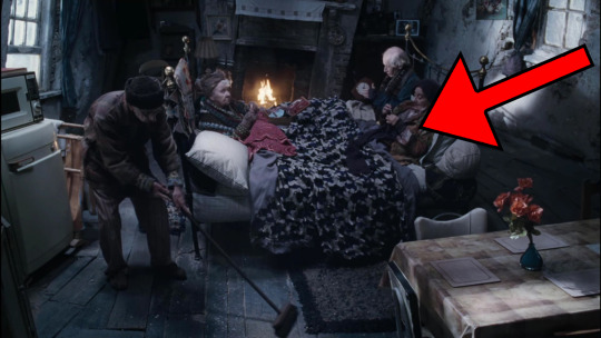
The light reflecting through the window in the Bucket home behind Grandpa George and Grandma Georgina on February 2nd points toward the southeast, which is not just scientifically inaccurate, but also incompatible with the northern Bucket home hypothesis.
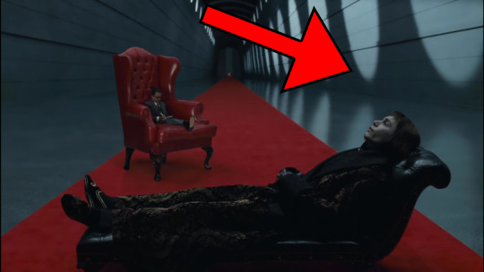
The light reflecting through the windows that run along the eastern wall of the factory corridor entrance building during Willy Wonka's therapy session reflects onto the western wall, meaning this takes place during the morning.

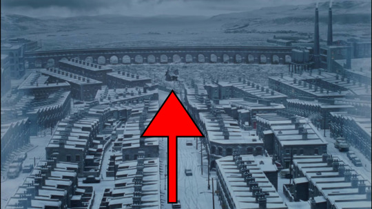
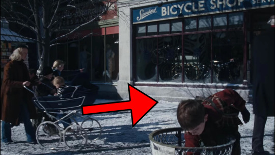
And the shadows of the pedestrians, trees, bench, fire hydrant and shoe-shining station while Charlie works as a shoeshiner point towards the north, meaning this takes place during midday.
So, following this utterly ridiculous analysis, we learned that 29 out of 31, or 93.55% of the shadows shown on screen point towards the Bucket home, or in that direction, as opposed to the factory. And because shadows face north in the northern hemisphere where London is, we can then use that information to establish the direction Charlie's town is facing, with the Bucket house on the northern edge of town.
On top of that, a deeper analysis reveals that the shadows pointing in the correct direction, that is to say all confirmed and suspected morning shadows point towards the northwest and all confirmed and suspected evening shadows point towards the northeast, as well as the sun rising in the east and setting in the west, account for 18 out of 31, or 58.065%, of all shadows. And so, with nearly every shadow pointing towards the Bucket home and more than half of all shadows pointing toward the direction that shadows during the time the scene is either confirmed to take place during or reasonably assumed to be taking place during should be pointing towards in order to be scientifically accurate, I can say that there is no refuting the fact that the Bucket home is on the northern edge of the Greater London region.
And as for the remaining 41.935% of shadows that do not fit in with the northern Bucket home hypothesis, I will say that we have to take into consideration the fact that much of the film was filmed on soundstages where artificial lighting is used instead of natural light, not to mention the fact that the filmmakers weren't even trying to be consistent with the direction their light source comes from.
Basically, there is no logic to the lighting apart from making the scene look as clear as possible. In fact, this is in part why the only two shadows that don't fit in with the northern Bucket home hypothesis happen in the Bucket home. But this also goes to show how a reliance on special effects and sets filmed on movie studios often result in scenes wrought with scientific inaccuracies. Also, I should also note that I have not yet seen the CinemaSins video on Charlie and the Chocolate Factory, but I assume that this shadow discrepancy wasn't even caught by them.
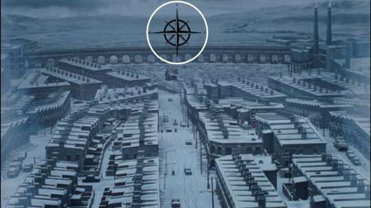
Now, as to the exact location of Charlie's town, we can use this most recent analysis to narrow down our list of London Burroughs from seven down to four. Because we know the Bucket home is on the northern edge of Greater London, we can eliminate the London Burroughs of Bexley, Bromley and Croydon as their northern regions border the deep urban core of London.

And with this narrowing down, we see that Charlie's town is located somewhere in the northeast quadrant of Greater London, specifically East London, a region infamous for poverty, lower-quality infrastructure than that found in posh central or West London and a working-class population, which just so happens to sound exactly like the kind of place Charlie's town would be located.
Unfortunately, due to how long this post turned out, we will need to split the content of this entry into two parts. Therefore, click here for Part 11 when we continue analyzing the remaining four London boroughs and the content of the film in order to narrow down our options and uncover just where in Northeast Greater London is Charlie’s town located.
Also, if you have better quality images of the scenes from the film I included in this post, feel free to share them with me so that I may replace the ones I used to improve the experience for the reader.
#unwrapping the wonka bar#charlie and the chocolate factory#charlie and the chocolate factory 2005#unwrappingthewonkabar#charlieandthechocolatefactory#catcf#catcf 2005
0 notes
Text
Suncalc!
Doesn’t looks like its been updated in years but OMG this is great!! Get the direction of the sun!
http://suncalc.net/#/57.0535,24.049,8/2023.06.14/14:33
0 notes
Text


12.27.20 - sun tracking
7 notes
·
View notes
Photo
I wrote a script that shows the world’s oldest sundial in action. This sundial was found in the valley of the kings and is dated by experts to 1500BC. The script transforms the output of suncalc into the angle of the sun based latitude/ longitude to display shadow angles for any time of day in history. Here is a time-lapse of March 3rd 1500BC. It uses suncalc, moment and three.js.
22 notes
·
View notes
Text
تحميل تحميل SunCalc org 3.5 APK لأجهزة الأندرويد احدث اصدار مجاناً
تحميل تحميل SunCalc org 3.5 APK لأجهزة الأندرويد احدث اصدار مجاناً
[ad_1]
يحاكي مسار الشمس – تطبيق للموقع الشهير: http://www.suncalc.org • يكتشف مسار الشمس ، الشروق ، ذروة الشمس ، الغروب
• يعرض السمت والارتفاع وطول الظل لكل موقع وفي كل مرة
• تكوين كل هذا على الخريطة
تنزيل APK
معلومة اضافية
صفقة
de.th.suncalcorg
الإصدار
3.5
بحجم
4.38 ميجابايت
طورت بواسطة
تورستن هوفمان
[ad_2]
التحميل من المصدر
View On WordPress
0 notes
Photo


Eclipse at Sunrise I/II
Canon T3i
6.10.2021
Yet another exercise in sunrise alignment for us, thank goodness for suncalc.org! A few days ago there was a partial solar eclipse visible in the midwest at sunrise, with totality being visible in eastern Canada. @all-hail-the-kazoo, @all-hail-the-conn-8d, and I worked on finding suitable viewing locations in our area, trying to keep the horizon as low as possible with all the hills around us, and Aly and I chose to stake out on a bridge where we could align the rising sun with a railroad trestle/girder bridge crossing the river. Suncalc wasn’t quite right with the sunrise time, meaning it probably doesn’t account for topography to fine detail, but the shots were definitely worth it. I have one more that I was gonna include here, but its representation of the colors going on felt somewhat jarringly different, so I’ll post it separately. I also just noticed that the last photos I posted before running out of motivation were from another solar eclipse 4 years ago, which should tell you how far behind I am with posting my photography on here.
#photography#queer artists#solar eclipse#sunrise#astrophotography#landscape#wisconsin river#railroad#god I haven't had to figure out tags in so long#not even sure if they really do anything tbh#I think reblogs tend to be more effective in having people find my photography#(hint hint if I'm not being annoying)
78 notes
·
View notes
Text
Digital Grimoire Update
Continuing my saga of finding a way to make my tiny Raspberry Pi into a functioning Grimoire and witchy data source, I have been working on my command line interface (CLI) program in Javascript (my first programming language was Java; don’t @ me XD) and I’m starting to outline how I want the program to function. Here’s a few things I’ve lined up to be able to include. I need to
General Grimoire - shows index of pages. Can open any pages. Maybe will enable you to open pages in Vi or Vim to edit within Command Line? I need to work on this element.
Search for X - this is more of a glossary. If I type in a tarot card, an herb, a crystal, a color, I want a general return of information on that thing. Downside, not sure I can tie this into the grimoire, so I may have to routinely update definitions as I discover connections between things on a more personal level?
Fortune Telling - directly modified port of my rune casting and cartomancy bot for Discord. This is probably going to be the easiest segment to get working, since a lot of it is already “done” but also could be tricky. Need to rework my rune casting emoji grid into ASCII art.
REAL TIME INFORMATION - This is the bit I am most excited for. I want to be able to ask what the moon phase is, what the weather is like, when the next equinox is... I want all this stored in an easy to search method. Certain libraries already exist to assist with this. SunCalc, for example, can get me sun/moon information including “what is the darkest part of the night?” I am doing a lot of searching though NPM packages at the moment to find things that might apply and also look maintained/accurate in use.
Currently I feel like this more interactive part of the bot could be called a “familiar” as it is fetching information for you and helping you interpret it from raw data to what you need. I am not sure if the terminology is good with that though. Second opinions are great.
13 notes
·
View notes
Photo

App Review: SunCalc and MoonCalc https://ift.tt/32otOwa
2 notes
·
View notes
Note
ezen gondolkodtam én is és ezért akarom kipróbálni mert nem azt állitja a poszt hogy akkor lesz éjszaka hanem hogy akkor kerül a relativ horrizont alá a nap. szal elvileg egy lakótelepen is meg tudnád ezzel mérni - természetesen dél után - hogy mikor süllyed a nap egy ház(tetejével egy vonalban lévő horrizont) mögé
Próbáld ki SunCalc-on. Minél közelebb vagy a pólusokhoz annál kevésbé megy a nap a horizont felé. Cserébe viszont annál tovább tart, hogy lemenjen (már ha lemegy).
Egy példa: nyári napforduló Reykjavik, este 21:00-kor a nap 11.85° magasan van 22:00-kor meg 6.66° magasan.(azaz 5.2° egy óra alatt). Cserébe Lagosban aznap 11.85° az 18:08-kor van, és 6.66° meg 18:32-kor, azaz itt 24 perc alatt megy le ugyanannyit a nap, mint Reykjavikban egy óra alatt. Ez több mint dupla idő ami azért elég jelentős különbség.
Amúgy ha tudod, hogy a nap a ráktérítő/baktérítő között tud csak delelni, és tudod, hogy napfordulókor a sarkoknál nem megy le a nap, akkor ebből a két tényből matematikailag is kijön, hogy az egyik helyen gyorsabban mozog a nap a horizonthoz képest, mint a másikon (hisz az egyenlítőnél 0°-ról felmegy 90°-ig, majd vissza a horizont alá, míg a sarkkörnél se nem megy el 90°-ig (sőt), de le se megy 0° alá ugyanannyi idő alatt)
7 notes
·
View notes
Link
Establishing the time within a video or image can be a difficult and frustrating task for open sourc...
0 notes
Link
Find out where the sun will be at any time in any location
0 notes
Photo

SunCalc 1.9: Tiny Library for Calculating Sun/Moon Positions and Phases - https://t.co/8CBxbgZHkH
0 notes
Photo

SunCalc 1.9: Tiny Library for Calculating Sun/Moon Positions and Phases - https://t.co/8CBxbgZHkH
0 notes
Text
Estudio de Soleamiento en Doñana
Debido a que la propuesta lo requiere, he decidido hacer un estudio de soleamiento en Doñana para así determinar con exactitud el posicionamiento de las protecciones solares y conseguir las específicas zonas de sombra en las áreas de descanso propuestas.
Para este estudio he hecho uso de la Carta Solar de la zona
En internet podemos encontrar algunas herramientas que nos proporciona la carta solar para el lugar que queramos. También nos indican el ángulo de acimut y elevación para la hora y el día deseado.
Suncalc: es una aplicación que muestra el movimiento del sol sobre un mapa en el lugar y el día que queramos. Podemos movernos por las horas del día y ver la posición del sol.
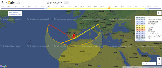
(Esta imagen solo sirve como referencia de uso de la aplicación, la localización aquí no es exacta)
Estudio en la localización exacta
Ya dentro de la web he procedido a ubicar la coordenada correspondiente a Doñana.
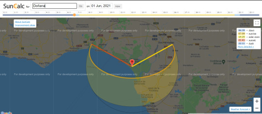
Siendo esta la ubicación podemos comprobar que en los periodos más calurosos el Sol se encuentra en su máxima altura respecto al horizonte.
Y respecto a la temporada más fría el sol se encuentra en su menor altura, estando en su punto más cercano con respecto al horizonte.

De todos modos, gracias a este estudio se comprueba el movimiento del sol, en este caso (Doñana) nos determina como deberán ser ubicadas las protecciones solares (Cubriendo mayoritariamente la línea naranja del desplazamiento del Sol de Este a Oeste, en Verano cubriendo el sol alto y en las demás épocas el sol medio-bajo)
0 notes
Text
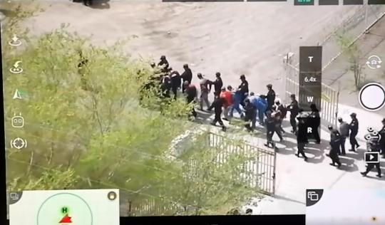
How a geo tracker confirmed that the drone footage of the train prisoners was filmed in xingjiang.
How Nathan Ruser was able to exactly find out where this footage was taken is absolutely remarkable.
-----------------------------------------------------------------------------
4 days ago a video showing 3-400 detainees handcuffed & blindfolded at a train station in Xinjiang was uploaded to YouTube (https://youtube.com/watch?v=gGYoeJ5U7cQ…) In this thread I'll share how I've verified that this video was filmed at 库尔勒西站 (41.8202, 86.0176) on or around August 18th.
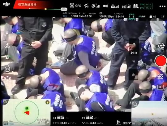
Firstly, let's look at the video. It shows a screen recording of a dji drone which has captured hundreds of detainees (presumably Uyghurs) being led off of a train, and lined up - freshly shaven, blindfolded and handcuffed - at a train station.
In terms of information to verify this video, it is quite scant. The title mentions that it shows something in Xinjiang, and the description says that it was 'taken in China' - "这些视频是在中国拍的", which is not a lot to work with.
Moreover, this is the only video uploaded to a new account, but let's look at what there is available for us to geolocate: building, cell-tower, blue buildings, carpark, trees, train tracks ect.
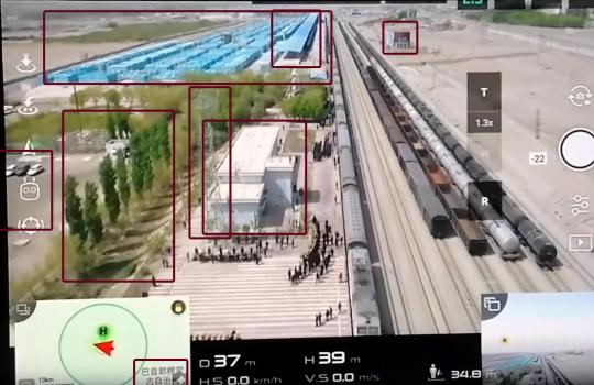
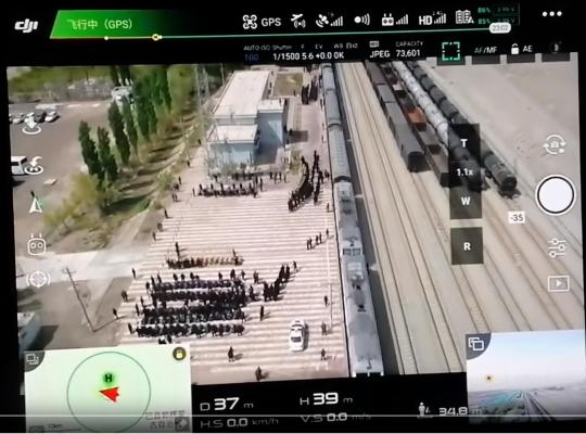
The biggest clue is the orientation map in the bottom left that says (after a bit of squinting & checking Baidu Maps) "巴音郭楞蒙 古自治州", an autonomous prefecture in Xinjiang that is often largely synonymous with the city of Korla. This was clearly filmed to the NW of there.
The drone's FPV camera is also pointing almost straight down the train tracks, which shows the orientation of the tracks at about 282° if you measure it. This narrows down the section of train tracks that it could potentially be.

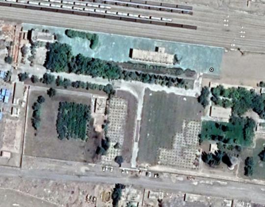
The bigger clue lies in the 10km scale bar in the bottom left, which (on my screenshot) represents 6.48cm. The distance from the approx centre of Bayingol label to the location is 8.05cm (at a bearing of ~ 300°) (8.05/6.48)*10 = 12.42km at a bearing of 300° from the label.
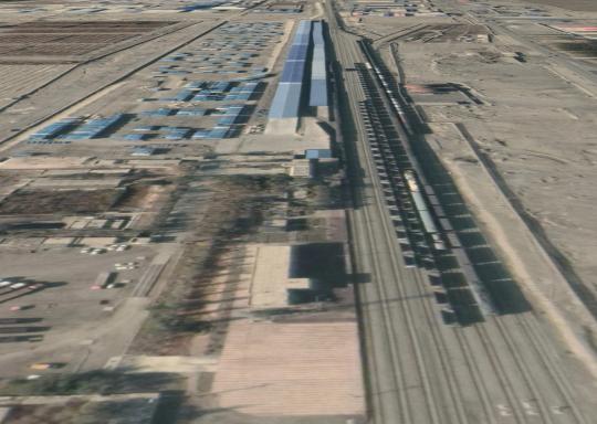
Feeding that into Google Earth gets you pretty bang on. You can see the building, the trees, the tracks, the car-park (which was in the process of being paved in the June 17th 2019 satellite image - important later!)
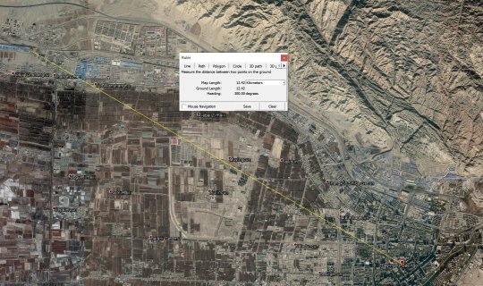

Indeed, just look at this. It's pretty clear where this video was taken (also just want to shout out to the Chinese script were the exact point of the label could be determined because each character is a square).

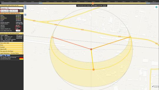
Now, to work out when this video was taken. Luckily the world is full of little sundials. See this telegraph pole. It casts a shadow which is conveniently clear, ending about 8 white lines away from the pavement, and in line with (or ~ a foot past) where the stripes get shorter.

This puts the shadow's end at about exactly this position. The image in Google's collection where the shadow looks the closest is taken on 7th Sept 2019. Regardless we can show that the shadow is approx 5m long with a sun azimuth of 173.38°. This are all very approximate.

Now to reverse engineer how tall the pole is. The Google imagery shows a the pole's shadow at ~6.75m long. Looking in Digital Globe's catalogue we can also see the sun elevation was 52.8°. Feeding that into SunCalc we see that at that time an object 1m tall casts a 0.76m shadow.


6.75*(1/0.76) = 8.88 Therefore we know that the pole is ~8.88m tall. All we have to do to find an approximate date is play around with SunCalc (http://suncalc.org) and find the time/day where an 8.88m object casts a 5m shadow with a sun azimuth of 173.4°
These figures are approximate! You'll notice it changed from August 18th to August 20th, that's because when I re-did it for this thread it must have been measured differently by a few feet or degrees. This is impossible to avoid when youre measuring so fine with less detail.
The year is a trickier thing to determine, which has to be done through chronolocating the video with satellite imagery - matching and picking the difference between the video and various satellite images. In this video the carpark is not paved. It was being paved in June 2019.
This rules out August 20th 2019 as the date of the video (also the red-and-white stripey path was repaved green for some reason - it's remained green, not just covered for the nearby paving). The crackdown started 2017, so with context it is either Aug 2017 or 2018.
There aren't a lot of further clues, but the world does always change! So the best I could find are these two small bottom most bushes. In 2017 they weren't there. In 2018 they were. Therefore we can tell this video was filmed on/around August 20th 2018.


I should have mentioned the year in the first tweet of this thread, sorry, but I hadn't worked it out by then! Silly me just assumed it was 2019. This is why it pays off to check!
But essentially this thread offers some techniques to verify imagery that I hope you find helpful. By verifying it, you can essentially prove that it is real and true, that what you're seeing did occur, and that it's location and date is known with enough detail to make it useful.
source
0 notes
Last Seen Blogs

coffinhearts
ᵇᶫᵃᶜᵏ ﹠ ᵈᵉᵉᵖ ᵈᵉˢᶦʳᵉˢ⋅
danielmaarleveld
Daniël Maarleveld

vacuumkasur
Vakum Kasur

emeraldsmith-universe
Artist / Designer
stained-water
Hi I’m Chalk