#surfwx
Text
Mavericks, Half Moon Bay, California
With majority huge waves coming in during this time of year, transition seasons are perfect for catching some killer waves on the pacific coast. One particularly famous location where killer waves are something of a speciality is located in southern California’s Half Moon Bay. Discovered for its great surf only 20 or 30 years ago, the area has been one of the greatest surf locations in the United States. Some even compare the size of the waves to what you can find in Hawaii, which are some massive, over 40 feet, waves.

One reason for this intense wave population in the region is the steady convergence of winds during an onshore flow of winds. If you notice the Convergence of winds just under the High pressure symbol placed directly over Mavericks. This convergence of winds is highly due to the geography of the location. If you notice, the general shape of the coast leads winds to form into the pattern described. When these heavy onshore winds converge, massive waves can be created. This is also becasue waves are largely controlled by winds are not swells as most people might call them.

Currently, winds are generally parallel to the shoreline which is not the greatest scenario to develop large waves. This setup will change drastically, though, as the day goes on the surface flow will shift from being so parallel to the shore to a more direct inland flow. This is due to the differential heating of land and water. As the land warms much quicker than the water, high pressure forms over the land and draws in the cooler air out at sea. When we get this shift in winds is when the best waves will start to take shape all along the coast. Although, it will be sometime before we see our classic Mavericks waves.
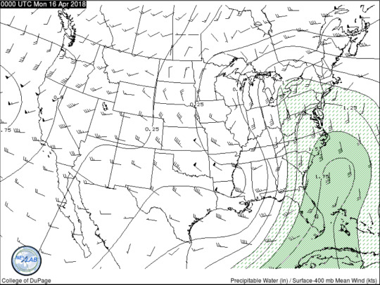
The mean winds between the surface and 400mb can tell us a lot about the vertical winds and how strongly they are influencing the surface behavior. This is extremely important in predicting scenarios like whether it is a good day for surf or not. Looking at this chart it is clear that the mean winds are actually most concentrated over the discussed Mavericks region. This will be important later in the day once the onshore flow has picked up and gotten into a full swing of intensity.
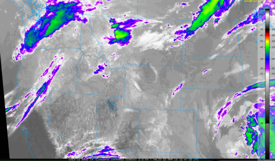
Since the sun has not yet risen over the great surf state, In order to look at what is happening in the atmosphere with a satellite I have pulled some fantastic GOES-16 imagery to provide a longwave infrared view of just exactly what is going on at this second. Just over the Mavericks regions you see a decent amount of cloud cover and some of those clouds even having a decent amount of ice concentration indicated by the darker green colorings on the map. This is particularly good for large wave development, just not good for the addition of a human trying to surf them. Early this morning the waters may be a bit too choppy for a paddle out, but later in the day this will shift. Although I do not see today being a good day for a surf due to the baroclinicity of the area and very little surface winds being produced.

The most gnarly waves are most likely set to roll through the area on friday afternoon justa around 11am. The chart above shows an upper air image of that time exactly. What I notice about the half moon bay region is the almost perpendicular positioning of the winds to the shoreline. This is imperative for large wave development like what we generally see with Mavericks becasuse without heavy winds attacking the shore so directly, you cannot get this type of phenomena that the great American surfing world has coined as the Mavericks. I am personally very intrigued by surf and weather. The two play hand in hand, and even though I’m no surfer I am an atmospheric scientist. Wherever you are If you need a surf foreast just let me know! I’m always down to weather nerd.
0 notes
Last Seen Blogs
love-musicheart
Writing, Art, Fangirling

heartoftheloathsome
† SINISTER SERVANT

mounfaredfoto
Mounfared

alitaarmy
ALITA ARMY

azariaspace
Love Each Other Well