#tropical depression
Text
Atlantic Tropical Weather Outlook issued by the National Hurricane Center in Miami, FL, USA
2024-04-24, 20:00 EDT

For the North Atlantic...Caribbean Sea and the Gulf of Mexico:
East-Central Subtropical Atlantic: An area of low pressure located about 900 miles northwest of the Cabo Verde Islands has been producing a small but persistent area of showers and thunderstorms to the east of its center since this morning. However, the low is forecast to move southwestward at 10 to 15 mph into an area of stronger upper-level winds tonight and tomorrow, and additional development is not expected.
No additional Special Tropical Weather Outlooks are scheduled for this system unless conditions warrant. Regularly scheduled Tropical Weather Outlooks will resume on May 15, 2024, and Special Tropical Weather Outlooks will be issued as necessary during the remainder of the off-season.
* Formation chance through 48 hours...low...10 percent.
* Formation chance through 7 days...low...10 percent.
$$ Forecaster Berg/Brown
#sorry the text was cut off at first! fixed now#the NHC changes the advisory formatting every year ever so slightly so i have to adjust how the bot parses them the first few posts lol#i am not a good coder and it shows lmao#bot tags:#bot post#meteorology#weather#tropical weather#tropical storm#tropical depression#hurricane#atlantic#atlantic ocean#caribbean#gulf of mexico#noaa#national oceanic and atmospheric administration#nhc#national hurricane center
15 notes
·
View notes
Text
🇦🇪 🚨
HEAVY SPRING RAINS BRING MASSIVE FLOODING TO THE UAE
📹 Scenes from Dubai International Airport, where flights have been diverted to Zayed International Airport in Abu Dhabi following intense flooding resulting from a tropical depression which dumped more rain over the previous 24-hours than has ever been recorded in the UAE.
According to local reporting, the National Center of Meteorology for the UAE announced that the effects of the depression has finally receded after dumping more than 100ml (over 6in) of rain in less than 24-hours for the first time in the country's history, resulting in flooding that saw multiple feet of water filling the streets of Dubai.
#source1
#source2
#videosource
@WorkerSolidarityNews
#dubai#abu dhabi#united arab emirates#uae#dubai news#uae floods#dubai floods#floods#flooding#middle east#middle east news#uae news#tropical depression#heavy rain#politics#news#geopolitics#world news#global news#international news#breaking news#current events
10 notes
·
View notes
Text


Life is but a dream 🌙
#oceancore#beachcore#poolcore#watercore#mermaid aesthetic#mermaidcore#siren aesthetic#sirencore#beach vibes#water aesthetic#mediterranean#mediterraneo#levant#dusky#dark ocean#dark yacht#dark beach#liminalcore#tropical depresh🍇#tropical depression#moody beach#moody aesthetic#moodboard#murky water#murky
15 notes
·
View notes
Photo

#Friedrich Kunath#Tropical Depression#religion#faith#humanity#humanity vs religion#religion vs humanity#religion is a mental illness
41 notes
·
View notes
Photo

Jordane Prestrot
Fuerteventura (2022)
Flickr . Instagram
26 notes
·
View notes
Text
You're fucking kidding me, right? RIGHT? FUCK YOUUUUUUU
4 notes
·
View notes
Text
apparently a tropical depression is aproximating where i live
this country is small compared to others and honestly is a little scary taking in count the amount of trees that could easily fall to houses and flooded streets
the coasts are in great danger and the rest of the departments aren't totally safe from the strong winds and storms
my house is in a safe zone, but im worried for my siblings living in the city (zone that is considered in danger)
just hoping that they will be okay
3 notes
·
View notes
Text
Tropical Depression would be a great title for my memoirs.
9 notes
·
View notes
Text

Eastern Tropical Atlantic:
Environmental conditions are forecast to be conducive for gradual development of this system, and a tropical depression is likely to form this weekend or early next week while the system moves generally westward at 10 to 15 mph across the eastern and central tropical Atlantic.
Formation chance through 48 hours…medium…50 percent.
Formation chance through 7 days…high…80 percent.
#National Hurricane Center#Tropical System#Tropical Weather Forecast#Hurricane Season 2023#Tropical Storm Season#Eastern Tropical Atlantic#tropical depression
0 notes
Text
Atlantic Tropical Weather Outlook issued by the National Hurricane Center in Miami, FL, USA
2023-09-03, 02:00 EDT
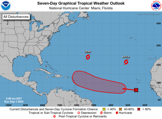
Active Systems: The National Hurricane Center is issuing advisories on Tropical Storm Gert, located about 700 miles east-southeast of Bermuda, and Tropical Storm Katia, located about 850 miles north-northwest of the Cabo Verde Islands. Eastern and Central Tropical Atlantic (AL95): A tropical wave located over the far eastern tropical Atlantic is producing disorganized shower and thunderstorm activity to the south-southwest of the Cabo Verde Islands. Environmental conditions appear conducive for some gradual development of this system by the middle part of this week, and a tropical depression is likely to form while it moves westward to west-northwestward at 15 to 20 mph over the eastern and central portions of the tropical Atlantic.
* Formation chance through 48 hours...low...30 percent.
* Formation chance through 7 days...high...70 percent.
$$ Forecaster Pasch
#bot post#meteorology#weather#tropical weather#tropical storm#tropical depression#hurricane#atlantic#atlantic ocean#caribbean#gulf of mexico#noaa#national oceanic and atmospheric administration#nhc#national hurricane center
44 notes
·
View notes
Text
Tropical Storm Harold makes landfall in Texas, bringing heavy rain and flooding ⛈️ Tuesday, 22 August 2023

Tropical Storm Harold has landed in Texas🚨, bringing heavy rain and flooding. The storm is expected to continue to move inland overnight and into Wednesday morning.
The National Hurricane Center has issued a 🌊flash flood watch for parts of Texas and Oklahoma. Residents in these areas should be prepared for flooding and take precautions to stay safe.
#tropical storm harold#hurricane watch#tropical storm#severe weather#tropical depression#texas#heavy rain
0 notes
Text
Hurricane Season 2022
The Atlantic hurricane season of 2022 is over
Hurricanes in the Atlantic
The Atlantic hurricane season officially ends on November 30th. As a result, the 2022 season concluded today. This does not rule out the possibility of a tropical system forming outside of season, so any atmospheric disturbances must be continuously monitored.
The Atlantic hurricane season begins on June 1st and lasts…

View On WordPress
1 note
·
View note
Photo

Jordane Prestrot
Fuerteventura (2022)
Instagram . Flickr
18 notes
·
View notes
Text
Atlantic Tropical Weather Outlook issued by the National Hurricane Center in Miami, FL, USA
2023-09-28, 14:00 EDT

Active Systems: The National Hurricane Center is issuing advisories on Tropical Storm Philippe, located several hundred miles east of the northern Leeward Islands, and on newly formed Tropical Storm Rina located over the tropical central Atlantic.
&& Public Advisories on Tropical Storm Rina are issued under WMO header WTNT33 KNHC and under AWIPS header MIATCPAT3. Forecast/Advisories on Tropical Storm Rina are issued under WMO header WTNT23 KNHC and under AWIPS header MIATCMAT3.
$$ Forecaster Cangialosi
#bot post#meteorology#weather#tropical weather#tropical storm#tropical depression#hurricane#atlantic#atlantic ocean#caribbean#gulf of mexico#noaa#national oceanic and atmospheric administration#nhc#national hurricane center
14 notes
·
View notes
Text
Atlantic Tropical Weather Outlook issued by the National Hurricane Center in Miami, FL, USA
2023-08-21, 02:00 EDT

Active Systems: The National Hurricane Center is issuing advisories recently upgraded Tropical Storm Gert, located several hundred miles east of the northern Leeward Islands, on Tropical Storm Emily, located a little over 1000 miles west-northwest of the Cabo Verde Islands, and on Tropical Storm Franklin, located over the eastern Caribbean Sea.
Western Gulf of Mexico (AL91): Showers and thunderstorms continue in association with a trough of low pressure located in the eastern Gulf of Mexico. Environmental conditions appear favorable for development of this system while it moves westward at about 15 to 20 mph across the central Gulf of Mexico. A tropical depression or storm is likely to form while it approaches the western Gulf of Mexico coastline by Tuesday. Interests in the western Gulf of Mexico should monitor the progress of this system. Tropical storm watches or warnings may be necessary on Monday for portions of the southern Texas and northern Mexico coastlines.
* Formation chance through 48 hours...high...70 percent.
* Formation chance through 7 days...high...70 percent.
Eastern Tropical Atlantic (AL92): A large area of disorganized showers and thunderstorms over the far eastern tropical Atlantic is associated with a tropical wave located near the Cabo Verde Islands. Environmental conditions appear conducive for gradual development of this system, and a tropical depression is likely to form later this week while it moves west-northwestward across the eastern tropical Atlantic.
* Formation chance through 48 hours...medium...40 percent.
* Formation chance through 7 days...high...70 percent.
&&
Public Advisories on Tropical Storm Emily are issued under WMO header WTNT32 KNHC and under AWIPS header MIATCPAT2. Forecast/Advisories on Tropical Storm Emily are issued under WMO header WTNT22 KNHC and under AWIPS header MIATCMAT2.
Public Advisories on Tropical Storm Franklin are issued under WMO header WTNT33 KNHC and under AWIPS header MIATCPAT3. Forecast/Advisories on Tropical Storm Franklin are issued under WMO header WTNT23 KNHC and under AWIPS header MIATCMAT3.
$$ Forecaster Roberts
#meteorology#bot post#weather#tropical weather#tropical storm#tropical depression#hurricane#atlantic#atlantic ocean#caribbean#gulf of mexico#noaa#national oceanic and atmospheric administration#nhc#national hurricane center
11 notes
·
View notes
Text
Atlantic Tropical Weather Outlook issued by the National Hurricane Center in Miami, FL, USA
2023-08-23, 14:00 EDT

Active Systems: The National Hurricane Center is issuing advisories on Tropical Storm Franklin, located inland over the Dominican Republic. The Weather Prediction Center has issued the final advisory on Post-Tropical Cyclone Harold, located inland over northern Mexico.
Central Subtropical Atlantic (Remnants of Emily): An area of low pressure more than 1000 miles miles northeast of the Leeward Islands (the remnants of former Tropical Storm Emily) continues to produce a large area of disorganized showers and thunderstorms northeast of its center. Upper-level winds are forecast to become more conducive for development by tomorrow, and this system is likely to regenerate into a tropical depression or tropical storm late this week or this weekend when the system moves northward over the subtropical central Atlantic. For additional information on this system, including gale warnings, see High Seas Forecasts issued by the National Weather Service.
* Formation chance through 48 hours...medium...60 percent.
* Formation chance through 7 days...high...70 percent.
Eastern Tropical Atlantic (AL92): Disorganized showers and thunderstorms continue in association with an area of low pressure located several hundred miles west of the Cabo Verde Islands. Environmental conditions appear only marginally favorable for some slow development through early next week while the system moves west-northwestward to northwestward into the central tropical Atlantic.
* Formation chance through 48 hours...low...10 percent.
* Formation chance through 7 days...low...30 percent.
&&
Information on Post-Tropical Cyclone Harold can be found in Public Advisories issued by the Weather Prediction Center, under AWIPS header TCPAT4, WMO header WTNT34 KWNH, and on the web at www.hurricanes.gov.
High Seas Forecasts issued by the National Weather Service can be found under AWIPS header NFDHSFAT1, WMO header FZNT01 KWBC, and online at ocean.weather.gov/shtml/NFDHSFAT1.php
$$ Forecaster Papin/R. Zelinsky
#meteorology#bot post#weather#tropical weather#tropical storm#tropical depression#hurricane#atlantic#atlantic ocean#caribbean#gulf of mexico#noaa#national oceanic and atmospheric administration#nhc#national hurricane center
11 notes
·
View notes
Last Seen Blogs

searchgoodmusic-blog
The Search for Good Music

ulcerousphlegm
Untitled

russellporterbroker
Russell Porter, Broker

toprankingsoftumbler
Top Ranking Lists

matricksbyksharma
Untitled