#u.s. geological survey
Text

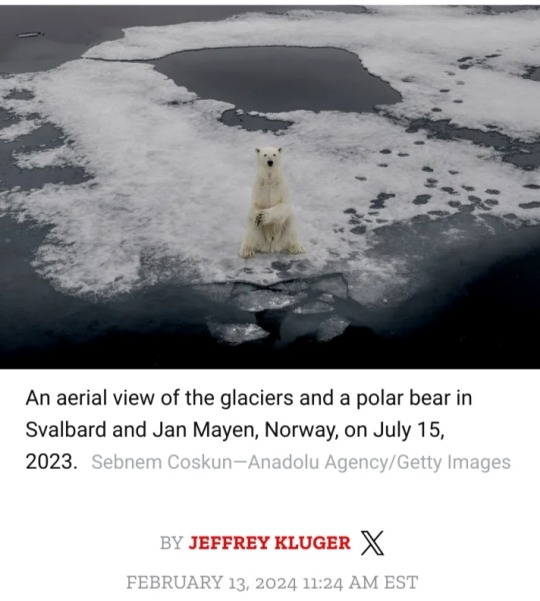
It’s not easy to swim 175 km (109 mi.) when you’re starving to death. It’s not easy either to try to survive when you’re shedding body weight at a rate of 1 kg (2.2 lbs.) a day.
And it might be hardest — or at least most tragic — of all if you’re a nursing mom and your calorie intake has dropped so low that you can no longer produce the milk you need to care for your young.
As a new paper in Nature Communications reveals, all of those challenges and more are facing the world’s polar bears, thanks to vanishing sea ice in our warming world, denying the animals a platform that they need to hunt for seals.
If the trend isn’t reversed soon, the estimated 26,000 polar bears in the wild could start to lose their hold on survival before the middle of this century.
The researchers were less interested in establishing the fact of the bears’ food plight; scientists are already aware of that problem.
What they were more focused on learning was both how gravely the nutritional loss is affecting the animals’ health and the alternative food sources they’re scrounging for on land.
To do their work, the scientists followed 20 different polar bears in Manitoba, Canada, from 2019 to 2022, fitting them with GPS trackers and video collars and periodically tranquilizing them and analyzing their blood, body mass, daily energy expenditure — basically a measure of calories coming in versus calories going out — and more.
“The polar bears in Hudson Bay [Canada] are probably at the edge of the range at which they can survive right now,” says Anthony Pagano, a research biologist with the U.S. Geological Survey and the lead author of the paper.
“Most of the modeling work suggests that around 2050, they are going to be on land and away from their primary habitat [on the ice].”
The contraction in range of the Hudson Bay community is likely to be reflected in the ranges of the 18 other polar bear subpopulations scattered throughout the Arctic as well.
Across the arc of the study, the data Pagano and his colleagues gathered was troubling.
Weight loss varied from bear to bear, with the daily loss of 1 kg representing just an average.
Some of the subject animals dropped up to 1.7 kg (3.75 lbs) every 24 hours.
That may not seem like much when an adult male polar bear can tip the scales at 550 kg (1,200 lbs) and a female at 320 kg (700 lbs), but it can add up fast.
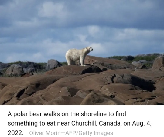
And with less available to eat, the hungry bears have to travel farther and farther distances to find their next meal.
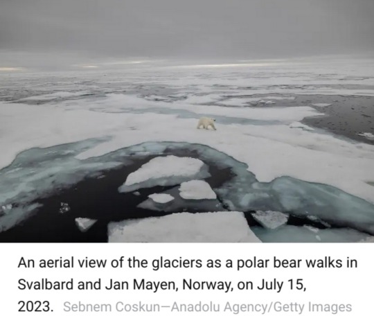
The individual that swam 175 km — a young female — set the record among the bears studied, but another, older female also covered 120 km (75 mi).
The endurance swims in search of food are energy-intensive and often fruitless for the bears.
They are efficient hunters when they’ve got the purchase of ice beneath them, Pagano and his colleagues explain, but they are clumsy when they are going after seals and trying to swim at the same time.
That leaves them scavenging on land for foods they would not ordinarily eat — and getting little payoff for their efforts.
“Polar bears are feeding on ducks and geese — catching them when they’re flightless and molting — as well as on their eggs,” Pagano says.
Other foods on the desperate bears’ menus included berries and other vegetation, bones, antlers and, in one case, a beluga whale carcass.
None of that fare is as calorie-rich as a steady diet of live, blubber-packed seals.
Some of the bears vigorously sought out these alternative sources of nutrition; others opted for a different strategy: resting and conserving the energy contained in their body mass.
The latter approach costs stored calories, but so does the former, as all of the plodding and searching burns through energy too.
“The amount of body tissue they were burning to try and find those terrestrial foods was basically the same as what they’d get from eating those terrestrial foods,” Pagano says. “So there’s no actual benefit.”
The researchers were surprised to find that the bears were going through not just fat stores to compensate for the poor rations but lean muscle tissue too.
Pagano is not certain why their metabolisms would adopt that strategy, but he has some ideas.
“There's some thought that burning lean body mass might be more energetically efficient in some respects relative to burning body fats,” he says.
“Also, conserving their body fat might provide them better thermal regulation once the winter and the ice return.”
That seasonal freeze-over is shorter than it used to be — though not by a lot.

In the 1980s, polar bears were on land for about 110 days out of the year, with no need to eat terrestrial foods since the fat deposits they’d accumulate thanks to wintertime seal-hunting was enough to carry them the rest of the year.
Now they're off the ice for 130 days on average.
It’s a measure of the nutritional knife’s-edge on which the bears operate that just 20 days can make the difference between whether they live and thrive or starve and die.
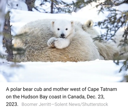
The individuals most likely to perish when food supplies are poor are young adults — due to their less-developed hunting skills — and cubs, whose principal source of nutrition, their mother’s milk, can vanish in lean times.
“If females are fasting for extended periods, they will actually stop lactating,” says Pagano.
Full-grown bears are by no means immune to danger, however.
The authors cite earlier research predicting that the adult male population could decrease by 24% if the ice-free summer season increases to 180 days.
This is especially so given the enormous energy intake — about 22,500 calories per day — that the big males need to maintain their body weight.
Polar bears aren’t the only species menaced by these findings. Humans are in harm’s way too.
The more time bears spend off the ice and on land, the greater the likelihood they will wander into cities and towns in search of something to eat — and residents could easily be hurt or attacked if they get in the way of the hungry animals.
People might also even be seen as sources of prey.
“When polar bears are on land, they act like other bears and become omnivores,” says Pagano. “It does raise the potential for human-bear interactions.”


🆘🐻❄️🥺
#polar bears#sea bears#Ursus maritimus#U.S. Geological Survey#Manitoba#Canada#Nature Communications#climate change#wildlife conservation#food source#nutritional loss#animal health#marine mammals#Arctic Circle
9 notes
·
View notes
Photo
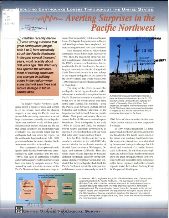
“The story of the efforts to meet this earthquake threat begins decades earlier, when earth scientists first recognized that the Pacific Northwest contains a boundary between two of the tectonic plates that make up the earth’s surface ... Deciphering the geological past is one of the ways that earth scientists help to protect citizens of the United States from loss of life and property in the future.”
Note: This is a digitization of a print article and does not appear to be in PDF format. As such, screen reader availability may be limited for this article.
U.S. Geological Survey. Averting surprises in the Pacific Northwest. Brian F. Atwater ... [et al.]. (1996). Full text available via HathiTrust.
#govpubs#1990s#1996#u.s. geological survey#pnw#earthquake#pacific northwest#brian f atwater#government publications#government documents#earthquake prevention#earth science#90s science#united states geological survey
7 notes
·
View notes
Text
Tonga 🇹🇴 Volcano Sparked the Most Intense Lightning Storm Ever Recorded
Last year’s eruption produced a raging storm at unprecedented altitudes, with 2,600 lightning flashes per minute at its peak
— Will Sullivan, Daily Correspondent | June 27, 2023 | Smithsonian Magazine
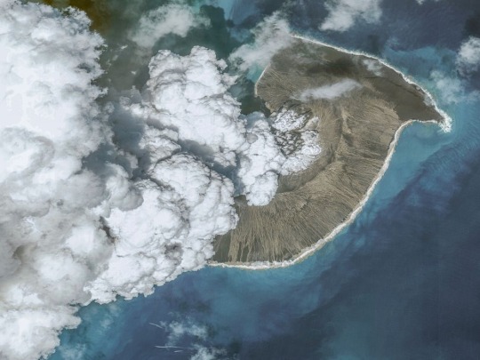
A photo of the Hunga Tonga-Hunga Ha’apai volcanic eruption taken on December 24, 2021, before the biggest eruption on January 15, 2022. Tsunamis caused by the eruption killed at six people in Tonga and Peru and displaced more than 1,500 people on Tongan islands. Maxar via Getty Images
On January 15, 2022, the underwater Hunga Tonga-Hunga Ha’apai volcano blew its top in a massive eruption, propelling a giant plume of ash and gas beyond the stratosphere. It was the largest recorded eruption since 1991, when Mount Pinatubo erupted in the Philippines.
Now, researchers say the 2022 eruption prompted the most intense lightning rates ever recorded, per a new study published last week in the journal Geophysical Research Letters. At its peak, the raging lighting storm produced 2,600 flashes per minute.
The scientists also detected lightning as high as an estimated 12 to 19 miles above sea level. Previous research elsewhere has only recorded lighting up to roughly 11 miles above sea level, according to the study.
“We’ve never seen anything like this sheer rate of lightning before—and at such high altitudes,” study co-author Alexa Van Eaton, a volcanologist at the U.S. Geological Survey, tells Space.com’s Keith Cooper.
“This is a fascinating study and shows how the Tongan eruption influenced the Earth system in ways that you might not immediately associate with a volcanic explosion,” Sam Purkis, a geologist at the University of Miami who did not contribute to the research, tells the Washington Post’s Kasha Patel.
Located near the islands of Hunga Tonga and Hunga Ha’apai in the South Pacific Ocean, the volcano started spewing ash on December 19, 2021. But its activity peaked with the cataclysmic eruption on January 15, resulting in tsunamis that caused the deaths of four people in Tonga and two people in Peru, the Guardian’s Nicola Davis wrote in April. The tsunamis also displaced more than 1,500 people on Tongan islands, and the eruption impacted over 80 percent of Tonga’s population.
The volcanic plume shot out of the ocean and reached a height of at least 36 miles above sea level. At its most intense moments, the volcano spewed out material at a rate of about 11 billion pounds per second—that’s the weight of more than 15 Empire State Buildings every second.
“It was clear right away that this was going to be a showstopping scientific event,” Van Eaton tells the Washington Post. “It’s several orders of magnitude larger than anything we’re used to looking at … This eruption clearly was going to teach us something new.”
Since last year’s eruption, scientists have been studying the event and adding to an ever-growing list of ways it made history. The volcano increased the amount of water vapor in the stratosphere by 5 percent, one study found. And that massive amount of water vapor could trap enough heat to temporarily warm Earth’s surface, according to another study.
For the new paper, the researchers examined records of the eruption from satellites and ground-based radio antennas. When viewing satellite imagery of the blast, they watched the volcanic plume rise and spread outward. Surprisingly, the lightning flashes also spread outward in four concentric rings, which matched the four phases of the eruption, writes Space.com.
Researchers had previously identified lightning in this circular pattern, but this was the first time they spotted multiple lightning rings.
Lightning, which is caused by an imbalance of electrical charges, occurs during volcanic eruptions when bits of ash brush against each other, creating charged particles, and similarly, when ice particles become charged.
“It may be that larger particles were going one direction and smaller particles were going in another, and that helped create the charge separation that leads to electrical discharges,” Van Eaton tells the Washington Post.
Researchers theorize that the lightning storm was so strong because of the eruption’s intensity, the rapid expansion of the ash plume and the large amount of vaporized seawater in the plume.
The volcanic plume may also be to blame for the high-altitude flashes: It could have raised the air pressure, leading the lightning to occur so high above sea level, Van Eaton tells Science News’ Skyler Ware. At the typical low air pressures at higher altitudes, it’s more difficult to form the channels of plasma that are necessary for lightning, according to the paper.
On top of all the existing evidence for how powerful and unusual this eruption was, the study demonstrates another way that the volcano led to unexpected events on and around the planet.
“Hunga has completely changed the way we think of how natural events can change the atmosphere and the environment where we thought lightning could exist,” Jeff Lapierre, a co-author of the study and lightning scientist at the company Advanced Environmental Monitoring, tells Science News.
#Tonga 🇹🇴 Volcano#Lightening Storm#Eruption#Hunga Tonga-Hunga Ha’apai Volcano#Tsunamis#2600 Flashes/Minute#U.S. Geological Survey
1 note
·
View note
Link
A Proud Tradition of Mapping the Nation
0 notes
Text

On Windsor Trail
Sangre de Cristo Mountains
9,405 ft benchmark
1939
New Mexico 2023
#U.S geological survey#elevation#bench mark#1939#hiking tail#windsor trail#sangre de cristo#new mexico
0 notes
Text
youtube
"You can watch USGS’s livestream here…." Kīlauea Volcano Live Stream - Halemaʻumaʻu crater - U.S. Geological Survey (USGS)
0 notes
Text


Oldest Known Black Swift Found in Colorado
This story from the field comes from Bird Conservancy of the Rockies biologists Rob Sparks and Colin Woolley:
“On August 1st 2023, we were excited to recapture a female Black Swift at a nesting site in Colorado, where it was first banded as an adult (after-hatch-year) bird in 2005!
That makes this swift at least 19 years old, breaking the longevity record set in 2022… by this very same swift! That’s right, this swift has been returning to nest at the same site since at least 2005, and has been recaptured 14 times over the years.
Research like this highlights the importance of long-term monitoring projects and what they can reveal about a species’ site fidelity and lifespan.
Right now, this swift is likely in Brazilian airspace, soaring over the Amazon Basin, where it will remain aloft for the entire overwintering period. Here’s to hoping this bird returns to nest in Colorado in 2024!”
All banding is being conducted under a federally authorized Bird Banding Permit issued by the U.S. Geological Survey’s BBL.
via: Western Bird Banding Association
4K notes
·
View notes
Text
The magnitude 6.2 earthquake struck near the boundary between the two provinces at a relatively shallow depth of 10 kilometers (six miles) just before midnight on Monday, the China Earthquake Networks Center said. The U.S. Geological Survey measured the magnitude at 5.9.
By mid-morning, 105 people had been confirmed dead in Gansu and another 397 injured, including 16 in critical condition, Han Shujun, a spokesperson for the provincial emergency management department, said at a news conference. Thirteen others were killed and 182 injured in Qinghai in an area north of the epicenter, according to state media. Another 20 were missing in Qinghai after being buried in a landslide, the China News Service said.
494 notes
·
View notes
Text

Fun fact: The standard North American NAD83 coordinate system is misaligned from the actual Earth, off-center by about 7 feet. Someone knows where I am, and I'm in the wrong place.
Survey Marker [Explained]
Transcript
[Zoomed in view of a round marker on the ground, with small specks of dirt around it. There is one line of text going around the central part in the outer rim of the marker, with the first three words written around the top, and the last two words written around the bottom (thus not text that are going all the way around in one single line). Inside this rim there are more text on three lines. In the center there is a small cross in a triangle pointing up in relation to the central text. There are more unreadable text below the last line of text and around the inner part of the rim. And off panel voice, which in the next panel turns out to be Cueball, is written above the mark.]
U.S. Geological survey bench mark Elevation above sea 447 feet
Cueball (off-panel): I love finding these survey markers. It's somehow reassuring.
[Cueball and Megan are show as they look down on the marker. Cueball has one leg on either side of the marker and Megan stands to the right.]
Cueball: I like that someone, somewhere, knows where this spot is.
Cueball: If I stand on it, they know where I am.
[Cueball and Megan looks up at each other.]
Megan: But the NAD83 and NAVD88 datums are getting replaced soon. That marker's coordinates could shift by like 5 feet.
[Megan is looking down at her phone in her hand, standing in the same relation to the marker. But Cueball is now floating in the air behind her 5 feet above the ground, while flailing with his arms and legs (as shown with three small curved lines at the end of either arm and above and below him.]
Megan: Oh look, it just got updated.
Cueball: Hey! Put me back!
372 notes
·
View notes
Text

PALS! It's Friday. It's the weekend. It's December.
Y'all made it another week.
We're glad you're here. Keep being you. 🤍🐻❄️🤍
- - - - - - - -
"Polar Bear Breaks Ice" by U.S. Geological Survey is marked with CC0 1.0.
#bear#polar bear#friday#friday polar bear#friday bear#fridaybear#cute#animals#nature#wildlife#outdoors#polar#arctic#arctic animals#december
325 notes
·
View notes
Photo
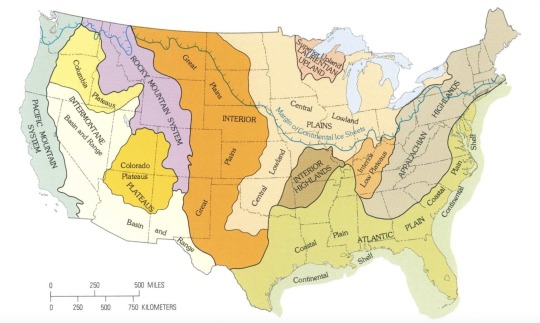
U.S. Terrain Regions Map by U.S. Geological Survey, 1980
366 notes
·
View notes
Text

Arroyo Toad (Anaxyrus californicus), tiny baby toadlet, family Bufonidae, southern California, USA
ENDANGERED.
photograph: U.S. Geological Survey/Chris Brownn
145 notes
·
View notes
Text
A NASA satellite has spotted a newly formed island off the coast of Japan that experienced a fiery birth at the end of October.
The joint NASA/U.S. Geological Survey satellite Landsat-9 saw the island rise from the sea off the coast of Iwo Jima island, part of the Volcano Islands archipelago in south Japan, on Nov. 3.
The island was born 750 miles (1,200 kilometers) south of Tokyo between 12:20 and 12:35 local time on Oct. 30 when blisteringly hot magma fell into the ocean and exploded, creating chunks of rock several feet long more than 160 feet (50 meters) into the air, according to the University of Tokyo.
"According to the Japan Meteorological Agency, the eruption appears to have started on October 21, 2023," University of Tokyo researchers wrote. "The location of this eruption is almost the same as the 2022 eruption location and is thought to indicate the resumption of magma activity on Iwo Jima."
Continue Reading.
92 notes
·
View notes
Text
Get ready to say goodbye to a lot of familiar bird names, like Anna's Hummingbird, Gambel's Quail, Lewis's Woodpecker, Bewick's Wren, Bullock's Oriole, and more.
That's because the American Ornithological Society has vowed to change the English names of all bird species currently named after people, along with any other bird names deemed offensive or exclusionary.
"Names have power and power can be for the good or it can be for the bad," says Colleen Handel, the society's president and a research wildlife biologist with the U.S. Geological Survey in Alaska. "We want these names to be powerful in a really good way."
The move comes as part of a broader effort to diversify birding and make it more welcoming to people of all races and backgrounds.
"We've come to understand that there are certain names that have offensive or derogatory connotations that cause pain to people, and that it is important to change those, to remove those as barriers to their participation in the world of birds," she says.
The project will begin next year and initially focus on 70 to 80 bird species that occur primarily in the United States and Canada. That's about 6 or 7 percent of the total species in this geographic region. (Read more at link)
As a birder, I like the idea. Descriptive names are helpful in birdwatching. And as the article explained, some names have already been changed like a longspur named after a confederate general. It's not like the birds care what they are named, any preference for current names is just sentimentality on our part.
96 notes
·
View notes
Photo

Walruses
Photographer: U.S. Geological Survey / Flickr / Public Domain
77 notes
·
View notes
Text
12 Sep 23
On September 4, the Japanese Supreme Court ruled that Okinawa Governor Denny Tamaki is legally obligated to approve the relocation of a U.S. military base from the Okinawan district of Ginowan to Henoko district in the prefecture’s Nago city. The decision follows Tamaki’s years-long legal battle to prevent the relocation after landfill work, which began in 2018, unearthed the fact that a significant portion of the sea floor where the base is being built was too soft to support the original construction plan.
In April 2020, the Japanese Defense Ministry’s Okinawa Bureau attempted to submit a revised building plan to account for the soft ground, which civil engineers described as “soft as mayonnaise,” but that was rejected by Tamaki in November 2021, after he claimed there was “insufficient research” into whether the revised plan would be feasible. Previous geological surveys indicated that the seabed was so soft that the base is likely to continuously sink. Tamaki claimed that “it was unacceptable to proceed with the construction of a new base that has no prospect of being completed.”[...]
Tamaki won a second four-year term in September 2022 by defeating Sakima Atsushi, who had the backing of the Liberal Democratic Party, which controls Japan’s government. Notably, Sakima was supportive of the U.S. base in Henoko. Tamaki’s re-election, while expected, thus highlighted how contentious the U.S. military still remains for the local populace given the unequal burden placed on Okinawa by U.S. bases.
While only accounting for 0.6 percent of Japan’s territory, the prefecture houses 70 percent of the 50,000 U.S. troops in the country[...] Okinawa has a crucial role in both Washington and Tokyo’s security posture toward China[...]
Despite that, many Okinawans have called for a reduction of military personnel on the island. A 2022-2023 public opinion poll conducted by researchers at several universities, including the University of the Ryukyus, found that nearly 70 percent of local residents think the heavy concentration of U.S. military personnel in Okinawa is “unfair.”[...]
the fortification of Japan’s defenses through Okinawa is also being used to counter [...] Russia and North Korea.[....]
it is highly unlikely that the Japanese prime minister will give in to the demands of the Okinawan people for a reduce U.S. military presence. This will ensure that anti-U.S. military sentiment will remain high on the island as Japan-U.S. security cooperation continues to strengthen.
14 Sep 23
79 notes
·
View notes
Last Seen Blogs

exols-world
WE ARE ONE

wallflower-me-blog
Untitled

thebspottv
Untitled

anzs
a n z s f o r r a s

pronhubb
Nutpuncher69®