#tennessee river valley
Text

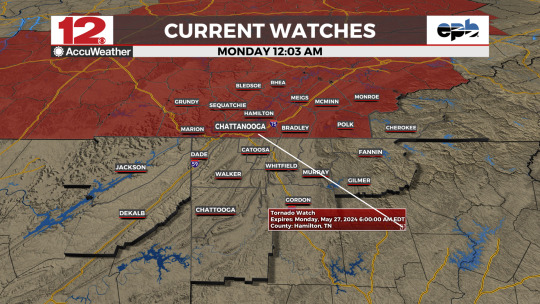
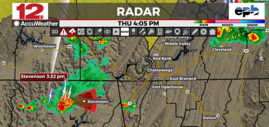
WDEFWeather #News12Weather -- #TornadoWatch 330 issued for NE Alabama, extreme NW Georgia until 8 AM CDT.
Tornado Watch 326 continues for SE Tennessee until 6 AM EDT / 5 AM CDT.
Stay tuned to @WDEFNews12 for updates.
#tennessee river valley#wdef.com/weather#chief meteorologist austen onek#chattanooga weather#[email protected]#wdef-tv#wdef chattanooga#wdef#wdef news 12#wdef.com
0 notes
Text
TornadoWatch 326 in effect for counties in SE #TNwx in the @WDEFNews12 viewing area until 6 AM EDT.
Primary threats include…
A few tornadoes likely with a couple intense tornadoes possible
Widespread damaging winds and isolated significant gusts to 80 mph likely
Scattered large hail and isolated very large hail events to 2 inches in diameter possible
Time to be #WeatherAware
#tennessee river valley#wdef.com/weather#chief meteorologist austen onek#chattanooga weather#[email protected]#wdef-tv#wdef chattanooga#wdef#wdef news 12#wdef.com#Tornado Watch#Severe Weather#Storm Prediction Center
0 notes
Text

Thanks to @WDEFNews12 viewer Barbara Davis of #ChattanoogaTN for a green view of the #Riverwalk area... Friday's @LangleyRoofing #WeatherWindow #PictureOfTheDay.
Got #weatherpix to share? Go to wdef.com/photos
#tennessee river valley#wdef.com/weather#chief meteorologist austen onek#chattanooga weather#[email protected]#wdef-tv#wdef chattanooga#wdef#wdef news 12#wdef.com#Langley Roofing#Weather Window#Picture Of The Day#Weather Pictures#Weatherpix#Weather in Pictures#Tennessee River Valley Pictures#viewer submitted photos
0 notes
Text
youtube
Finally to the much-awaited holiday weekend. Unfortunately the chances for severe weather will remain with the area into the holiday itself. In the worst case of bad timing: we'll see sunny skies and mild temperatures after the holiday.
All that and much more in tonight's WDEF News 12 exclusive video #weatherblog #WeatherOvertime. #ShareAndEnjoy
#WDEF#WDEF-TV#WDEF News 12#Chattanooga Weather#Chattanooga Tennessee#wdef.com/weather#News 12 Weather#[email protected]#Chief Meteorologist Austen Onek#Chattanooga meteorology#WDEF meteorology#Tennessee River Valley#WDEF weatherblog#News 12 weatherblog#WDEF News 12 Weather Overtime#Weather Overtime weatherblog#Weather Overtime#meteorology blog#Langley Roofing#Weather Window#Picture Of The Day#Weather Question Of The Day#Friend-In-Roofing.com#Weather Pictures#Weatherpix#Weather in Pictures#Tennessee River Valley Pictures#viewer submitted photos#Youtube
0 notes
Text
#WDEFWeather #News12Weather #BlipCast for Friday: Expecting a warm, humid and possibly stormy holiday weekend ahead of us.
More details tonight on @WDEFNews12 at 5:30, 6, 7 & 11 and at wdef.com/weather
#[email protected]#wdef.com#chief meteorologist austen onek#wdef chattanooga#wdef.com/weather#chattanooga weather#wdef-tv#wdef#tennessee river valley#wdef news 12
0 notes
Text

#WDEFWeather #News12Weather @WDEFNews12 - Brief heavy downpours possible in this severe thunderstorm over NE Hamilton County #TNwx, moving slowly NE @ 10 MPH. #TurnAroundDontDrown
#chattanooga weather#tennessee river valley#chief meteorologist austen onek#wdef.com/weather#wdef chattanooga#[email protected]#wdef-tv#wdef#wdef news 12#wdef.com
0 notes
Text

SEVERE THUNDERSTORM WARNING FOR
NW BRADLEY, SW MEIGS, NE HAMILTON IN EAST #TNwx UNTIL 445 PM EDT.
AT 400 PM EDT, A SEVERE THUNDERSTORM WAS LOCATED 9 MILES NE OF SODDY-DAISY, OR 12 MILES S OF DAYTON, MOVING NE AT 10 MPH.
HAZARD...60 MPH WIND GUSTS AND QUARTER SIZE HAIL.
#wdef.com/weather#tennessee river valley#chattanooga weather#chief meteorologist austen onek#[email protected]#wdef.com#wdef chattanooga#wdef#wdef news 12#wdef-tv#severe thunderstorm warning#NWS Morristown
0 notes
Text

Thanks to @WDEFNews12 viewer Anthony U. from Ringgold GA for a waterscape view of South Chickamauga Creek, Thursday's @LangleyRoofing #WeatherWindow #PictureOfTheDay.
Got #weatherpix to share? Go to wdef.com/weather
#chattanooga weather#wdef.com/weather#chief meteorologist austen onek#wdef-tv#[email protected]#wdef#tennessee river valley#wdef news 12#wdef chattanooga#wdef.com#Langley Roofing#Weather Window#Picture Of The Day#Weather Pictures#Weatherpix#Weather in Pictures#Tennessee River Valley Pictures#viewer submitted photos
0 notes
Text

WDEFWeather #News12Weather: Storm Prediction Center reduces threat for severe weather to a #MarginalRisk into overnight. More chances for severe weather over the next several days. Update on your holiday weekend forecast coming up tonight on @WDEFNews12 at 11.
#wdef.com/weather#tennessee river valley#chief meteorologist austen onek#wdef-tv#[email protected]#chattanooga weather#wdef#wdef chattanooga#wdef news 12#wdef.com
0 notes
Text
SEVERE THUNDERSTORM WARNING FOR...
NORTHWESTERN CHEROKEE COUNTY IN SOUTHWESTERN NORTH CAROLINA...
EAST CENTRAL BRADLEY COUNTY IN EAST TENNESSEE...
NORTHERN POLK COUNTY IN EAST TENNESSEE...
SOUTHEASTERN MCMINN COUNTY IN EAST TENNESSEE...
SOUTHWESTERN MONROE COUNTY IN EAST TENNESSEE...
* UNTIL 815 PM EDT.
* AT 729 PM EDT, A SEVERE THUNDERSTORM WAS LOCATED NEAR BENTON,
MOVING EAST AT 30 MPH.
HAZARD...60 MPH WIND GUSTS AND QUARTER SIZE HAIL.
#wdef.com/weather#chattanooga weather#tennessee river valley#wdef-tv#[email protected]#wdef#chief meteorologist austen onek#wdef news 12#wdef.com#wdef chattanooga
0 notes
Text

SEVERE THUNDERSTORM WARNING FOR NE MCMINN, NW MONROE IN EAST #TNwx in the @WDEFNews12 viewing area.
* UNTIL 800 PM EDT.
* AT 713 PM EDT, A SEVERE THUNDERSTORM WAS LOCATED OVER ATHENS, MOVING E @ 30 MPH.
HAZARD...60 MPH WIND GUSTS AND QUARTER SIZE HAIL
#chattanooga weather#wdef.com/weather#tennessee river valley#chief meteorologist austen onek#wdef-tv#[email protected]#wdef.com#wdef news 12#wdef#wdef chattanooga
0 notes
Text
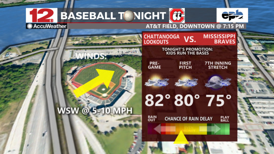
#WDEFWeather #News12Weather - Forecast for the hometown @ChattLookouts taking on the @mbraves in downtown #ChattanoogaTN will include mild temperatures but also a better than average chance of a rain delay with showers/thunderstorms developing. #PlayBall but be #WeatherAware
#wdef.com/weather#chattanooga weather#chief meteorologist austen onek#tennessee river valley#wdef-tv#[email protected]#wdef news 12#wdef#wdef chattanooga#wdef.com#Chattanooga Lookouts#Mississippi Braves#Minor League Baseball#Baseball Forecast#Baseball Weather Tonight
0 notes
Text
#WDEFWeather #News12Weather #BlipCast for Thursday: More stormy weather for the near future. Got plans for the upcoming holiday weekend? Tune in to the @WDEFNews12 forecast tonight on-air or on line.
#wdef.com/weather#tennessee river valley#chief meteorologist austen onek#chattanooga weather#[email protected]#wdef-tv#wdef chattanooga#wdef#wdef news 12#wdef.com
0 notes
Text

#WDEFWeather #News12Weather - Reports of dime-sized hail near #ResacaGA in the #severethunderstorm moving E @ 20 MPH.
@WDEFNews12
#wdef.com/weather#chattanooga weather#chief meteorologist austen onek#tennessee river valley#wdef-tv#[email protected]#wdef#wdef chattanooga#wdef news 12#wdef.com#Resaca Georgia#NW Georgia#Georgia Weather
0 notes
Text
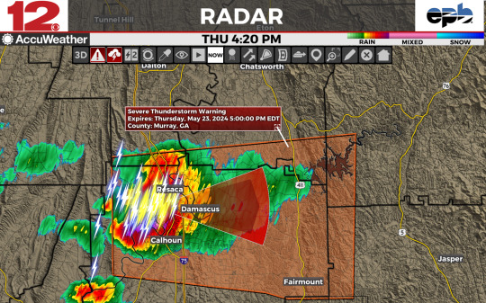
In the @WDEFNews12 viewing area:
SEVERE THUNDERSTORM WARNING NWS PEACHTREE CITY GA
SEVERE THUNDERSTORM WARNING FOR…
SW GILMER COUNTY
SW MURRAY COUNTY
SOUTH CENTRAL WHITFIELD COUNTY
GORDON COUNTY IN NORTHWESTERN GEORGIA…
UNTIL 500 PM EDT.
#chattanooga weather#wdef.com/weather#wdef-tv#chief meteorologist austen onek#[email protected]#wdef#tennessee river valley#wdef chattanooga#wdef news 12#wdef.com#Georgia Weather#NW Georgia Weather
0 notes
Text
#WDEFWeather #News12Weather
Special Weather Statement
National Weather Service Huntsville AL
At 226 PM CDT, Doppler radar was tracking a strong thunderstorm near Skyline, or 16 miles NW of Scottsboro, moving E at 25 mph.
HAZARD...Wind gusts up to 50 mph and pea size hail.
#wdef-tv#wdef.com/weather#chief meteorologist austen onek#chattanooga weather#tennessee river valley#wdef.com#[email protected]#wdef#wdef news 12#wdef chattanooga
0 notes
Last Seen Blogs

benboulette
Alex Walex

dabisdance
byebye

kadianphotography
Rooling-wheels

dodgeelway-blog
TripleElysianKc

decepticon-gurl-with-loki
November_girl_loki and cons