
Last Seen Blogs

cartoonsandmusic67
CartoonsAndMusic67

404fatalerror
Finally bugs fixed

nekoblu0o
Puppy GRL

lelaspitler54-blog
Untitled

kanamedate69
beef strokin off
Text
Cold and Wet day possible Wednesday in Starkville
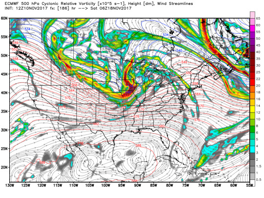
Good afternoon everyone! Today I am going to be forecasting for Starkville, MS though Thursday. First, I will go through the 300, 500, and 850 mb pressure levels on the GFS and Euro, and then I will go over soundings for the GFS, NAMNEST, and HRRR models. All runs are the 11/13/18 12z run
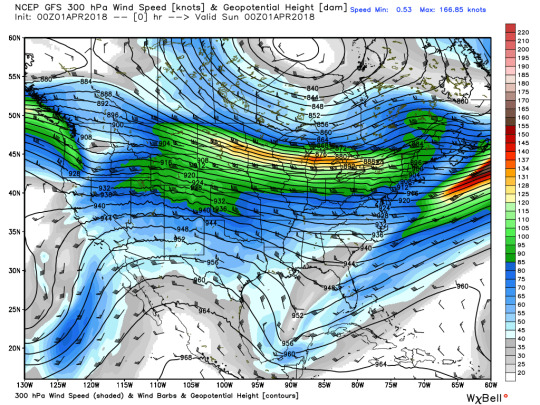
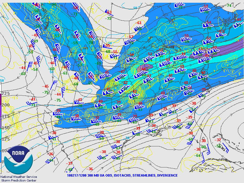
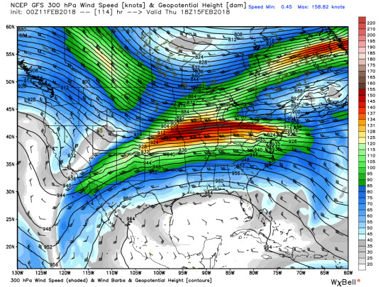
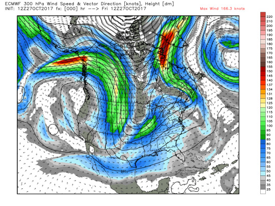
300 mb
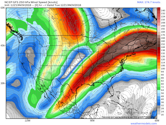
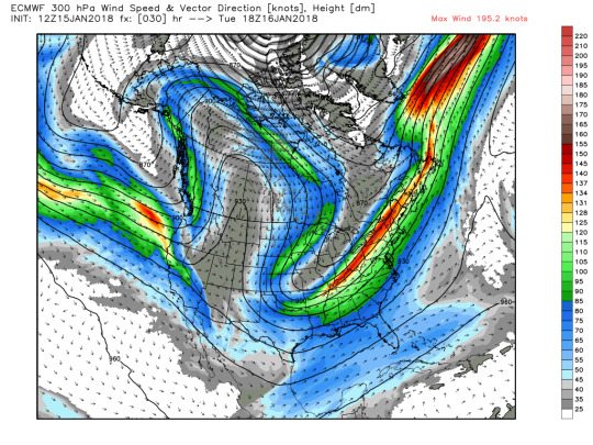
Both models initialized fairly well, showing a large jet streak stretching from East Mexico into Ontario. This slowly propagates east throughout the night and into tomorrow. The big difference between the two models, and this may be because I have to look at 250 for the GFS instead of 300, is the Euro shows a much thinner jet streak than the GFS does. With that said, the GFS also pushes it through faster than the Euro does. The euro has Starkville in the right rear quadrant for longer than the GFS does, so I would expect rising motion in this layer for longer if the euro is correct. However, I would expect more sinking motion if the GFS is right since Starkville would be more in the left rear quadrant. GFS has the switch more around 00z on Thursday, while the euro shows it more around 06z. Regardless, I expect rising motion in this layer during the day Wednesday.
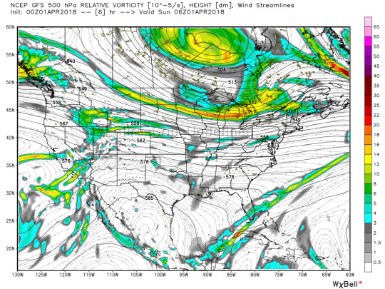
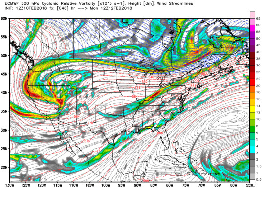
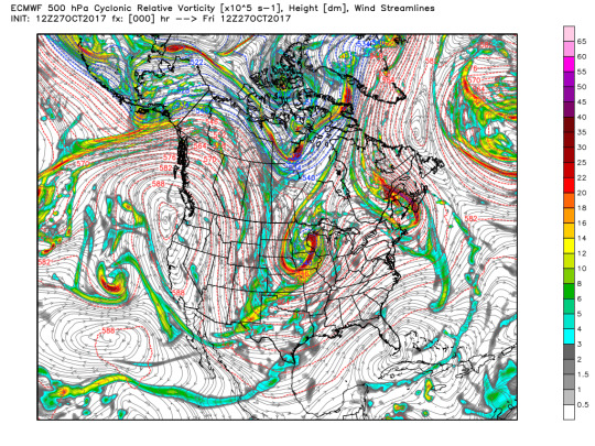
500mb
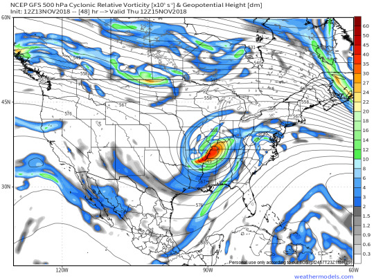
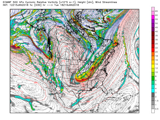
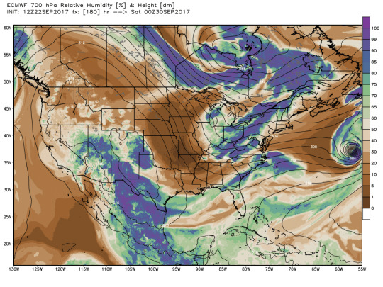
The Euro and GFS both initialized very similarly on this map. They both show a positively tilted shortwave trough centered over west-central Texas. This shortwave trough will gradually become cut off throughout Tuesday. While the models agree fairly well on the position of the trough, the GFS is a little less aggressive on the vorticity. Both models show PVA for Mississippi during the day Wednesday, suggesting rising motion. 00z-06z show some NVA based on the wind direction around the cutoff low, but both models do show some more PVA around 12z with a little tail off of the main area of vorticity. NVA will set in by 18z, bringing sinking motion. The low should clear the area completely by Thursday evening.
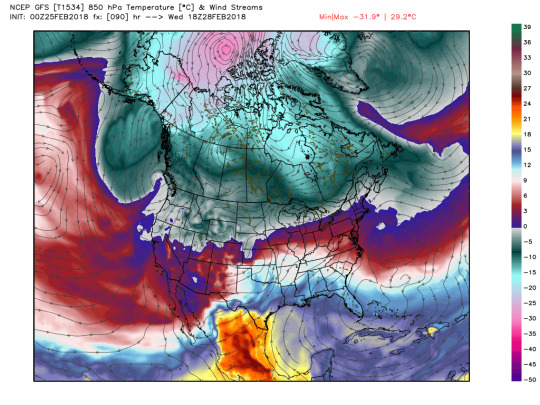
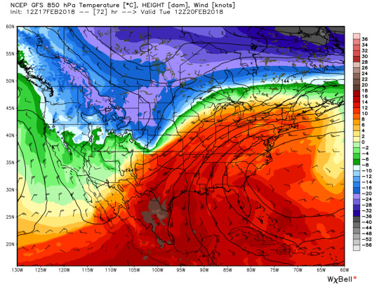
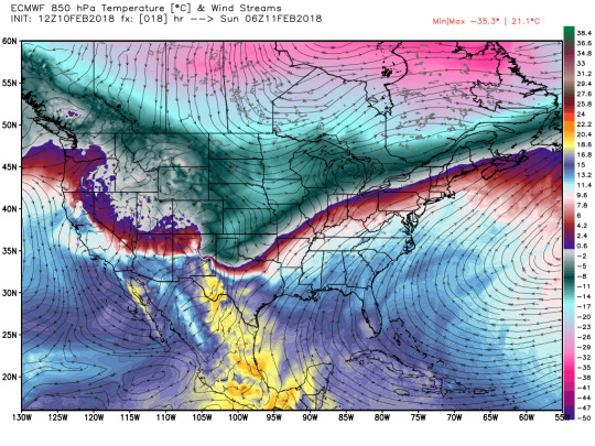
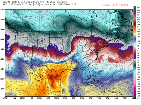
850mb
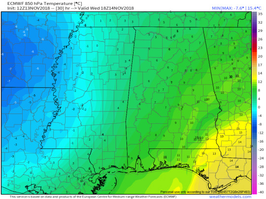
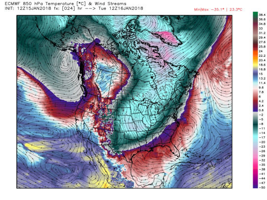
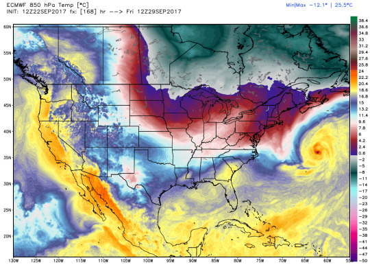
Once again, the euro and GFS initiate fairly similarly. By 12z Wednesday, the euro shows some Warm Air advection around Starkville, suggesting rising motion. This will become Cold Air advection by 00z Thursday; this suggests sinking motion. GFS is fairly close to this as well. *NOTE: The colors on this map are not the easiest to distinguish for me. Point is, WAA seems likely during the day, shifting to CAA during the late afternoon hours.

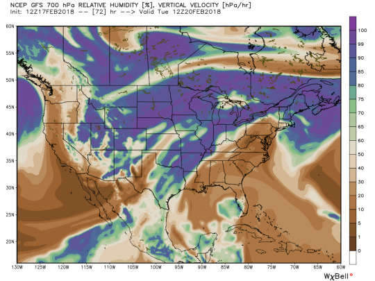
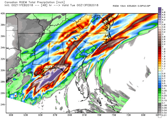
Sounding Analysis and EURO precipitation:
Now I wish to look at the precipitation potential of this system moving though. Reviewing from above, Wednesday should have the greatest chance of precipitation based on the rising motion, and now it’s time to look at the soundings to determine the chance of precipitation through Thursday. I will be mainly using bufkit for this, but I will use standard maps for the euro since I do not have soundings for that model.
EURO Surface analysis
Starting off with temperatures, Euro was a few degrees warmer than the actual temperature recorded at GTR temperature at 18z, at a cool 41 F forecasted versus 44 F. Keeping that in mind, the euro suggests a temperature of around 38 by sunrise Wednesday with a north wind around 8 knots. It expects no precipitation during the overnight hours. In fact, the euro expects very little precipitation on Wednesday at all. If any does fall, it would likely be rain based off of the surface temperature.
Sounding Analysis:
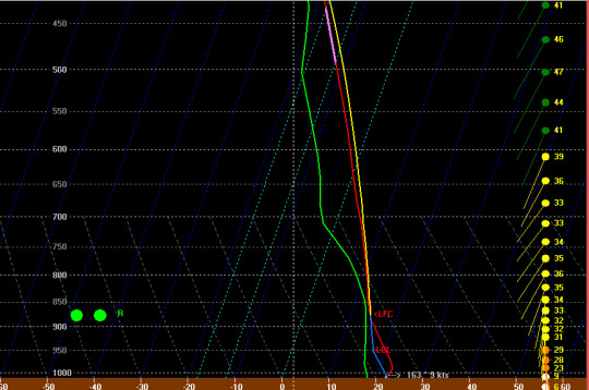
GFS
18z temperature suggested by the GFS is colder than the euro, and 5 F colder than the actually recorded temperature from the asos station. Throughout Tuesday night, there are very shallow layers where snowflakes could form, but it is unlikely any such flakes could survive both the 80 knot winds and the large dry pocket of air around 550mb. Moving to Wednesday morning, that layer of dry air will still prevent any snow growth, but there will be a saturated layer of air between 950 and 700. Surface temperatures are above freezing, so it should just be a cold rain. Total daytime precipitation should be less than a tenth of an inch. GFS is too dry Wednesday night for any measurable precipitation.
NAMNEST

NAM temperature is about the same as the GFS at noon Tuesday, so still about 5 off of the actual temperature. It has deeper levels of snow growth than the GFS does, but it still has fairly deep layers of dry air, so any flakes would likely evaporate before reaching the ground. The NAM does present a much wetter profile than the GFS does. This could present a slight problem as well. The 14z Wednesday hour presents a very saturated profile from the surface to about 13k feet. With the temperature at the ground being 32, this presents the risk for some light freezing rain. This risk should be gone by 16-17z. NAM continues to suggest light rain throughout the day Wednesday, with a total amount of around 0.15 inches. The profile dries right on out on Wednesday night, so the risk of any further precip is low.
HRRR
The HRRR temperature at 18z Tuesday is similar to the euro’s, so an error of about 4 degrees. The HRRR profile is overall warmer than the NAMs, and still has a dry layer which would inhibit any flakes from the snow growth region from making it to the ground. It is a bit rainier than the NAM is, so I would expect around 0.2 inches from this.
CONCLUSIONS
Overall, any rain tomorrow will be fairly light. Lower end temperatures could result in freezing rain, but it is unlikely to cause any problems. It is more likely to be just a cold, dreary rain, with temperatures being roughly in the mid 30s. I would bring an umbrella just in case.
Highs and Lows
Tues Low: 34 F
Wed High: 35 F
Wed Low: 30 F
Thurs High: 42 F
Thurs Low: 30 F
0 notes
Text
Getting this started back up
Good afternoon everyone! just letting my followers know that i’m going to start my forecasting blog back up! Look forward to some more forecasts, mainly focusing on Starkville and Birmingham.
0 notes
Text
Forecast for 4/1/18 Columbus, OH
Originally, I was going to do my forecast for the Cincinnati Reds’ opening day, but then it got called off. So I am turning my attention a little north to Columbus, Ohio. Mississippi State is playing in its second women’s basketball national championship on the first, and I want to look at what weather fans driving in can expect tomorrow. The models I will be mainly looking at today are the Euro, GFS, NAMNEST, and RGEM .
00z Sounding analysis vs 00z models
I do not have any pictures for this section mainly because they are not the easiest to pull from the programs. I took the nearest 00z sounding from NWS Wilmington OH and compared it to the 00z run of the NAMNEST. Overall, the sounding from the NEST looks pretty accurate to the sounding taken from NWS Wilmington. The initial temperature is about 1-2 C warmer than the nest though.
300 mb
Initially, both global models (12z Euro and 0z GFS, 0z euro was not in as of typing), have the upper air pretty well initialized. They have central Ohio in a right front quadrant of the jetstreak, so I would expect sinking motion associated with that. Forecast Sounding analysis with bufkit is inline with that as well showing positive omega near 300mb. By sunrise tomorrow, the euro has Columbus being in a right rear jetstreak. The GFS agrees with that as well. The jetstreak behind the one over the midwest connects with the trailing jetstreak by 00z monday on the GFS, still resulting in rising motion. The Euro agrees with this. Overall, I expect rising motion due to the jetstreak through the day tomorrow in Columbus with it transitioning back to sinking motion during that night.
500mb
At 6z, there is no major voticity in the Ohio area, there is a band of vorticity north into Michigan, but the wind profile is not bringing any into Ohio at that time. By 12z, the euro does have a band setting up in the Ohio River valley, so I expect rising motion to onset by midmorning sunday. More major PVA onsets by sunset on sunday, so I expect the best rising motion to be in the evening to nighttime hours. That will move out by monday morning leading to NVA and sinking motion. The GFS agrees with that general trend, but has small differences on the placement of vorticity maxima. Overall, I expect rising motion most of the day on sunday for columbus at 500 mb, at least from a vorticity standpoint. This does have to fight temperature advection at 500 too, so the rising motion is a little more delayed until afternoon. Speaking of temperature advection, that’s a great transition to 850 mb!

850mb
The models do not quite agree here unfortunately. They are pretty similar at 0 and 6z, showing WAA and CAA respectively, but the GFS has the winds shifting to the SW much further north than the Euro at 12z. GFS has minimal temperature advection in Ohio at that hour with the winds flowing mostly parallel to the temperature lines, while the euro has that shift south of Cincinnati. So, the GFS/NAMNEST have more of a rising motion profile here versus the euro, definitely an interesting clash considering the models have agreed pretty well up to this point. Overall, the Euro is definitely more consistent with that transition though. Both models return to agreement with CAA ruling for the rest of the day.
Temperature and precipitation:
Of course, a one day forecast would not be complete without a discussion about the temperatures that can be expected and how much precipitation there will be. I’m going to be discussing the temperatures first, along with winds.
NAMNEST showing a cold front moving through Columbus during the early morning hours on Sunday, and the temperatures fall to near freezing to freezing by sunrise, so any fans in Columbus are going to have a pretty chilly morning. The GFS is about 2 degrees C warmer than freezing by morning while the Euro agrees with the NEST. Winds are ok from the NNW, between 10-15 knots. Temperatures warm up pretty well, into the mid 40s. Euro has it around 47 F, GFS around 45, and the NEST around 43. That maxes around 21z, so its still about an hour before the tip-off of the national championship game.
Precipitation looks like it could be an issue before and after the game. Initially, the models are in agreement of the cold front that moves through between 6 and 12z sunday, that will bring some precipitation in the form of rain. Overall, the models agree that the cold front is not going to bring a large amount of rain. However, there is more disagreement on the models on the onset of precipitation for the evening. Euro and NEST agree that the second round of precipitation will onset during or after the game, past 00z, while the GFS is in a hurry and brings it in a little sooner. This does make a big difference since the GFS’s solution starts it out as rain while the other models start it as snow(or their algorithms do anyways). GFS has a real problem with a dry pocket at the surface, but as the precip intensifies, that gets eroded. Sounding shows mainly rain for that solution, with some mixed snow and rain possible later. By the time snow is really good temp wise, the moisture in the growth zone is gone. NEST is showing the precip initializing by 1z, and it will be a very wet snow with surface temps above 0C but a WBZ of less than 1kft. heaviest snow will be between then and 6z, past then will be freezing drizzle. About .35 inches of snow at a fairly low ratio. RGEM and Euro are harder to get a handle on snow wise since I do not have forecast soundings for them. Based on the maps I do have, the liquid QPF for those will be about .3 inches. Surface temperature on the euro is similar to the NEST, so I expect similar to the nest ratio wise.
OVERALL
MORNING LOW: 33 F with a breeze 10-15 Kts
DAYTIME HIGH: 45F with weaker winds
PRECIPITATION: about .3 of an inch liquid, 1.8 snow. I doubt it will stick, but weirder things have happened.
0 notes
Text
Synoptic analysis for starkville for 2/25-3/2
For my blog this week, I’m going to be returning to starkville for the week ahead. I’m gonna focus on synoptic scale analysis for this blog post. Near the end of the week, I plan on doing a post on various areas in Arizona. I will focus on that later this week for two reasons: 1) I want to do a blog post on each area starting with flagstaff after the WxChallenge forecasting period ends after it. Sort of a post analysis for what went right and wrong with my forecasts that two week period. 2) The Cactus League for spring training began play yesterday(as of posting), so the actual forecast component of that blog will focus on baseball weather. However, I will focus on starkville this week.
Some paragraphs may be lengthy, but there is some stuff to talk about and differences in the global models.
300mb:

Both the GFS and Euro initialized decently. 12z euro got the faster winds in the jet streak better, but both are missing a little bit of the streak over northern Alabama. For Sunday, the Euro has Starkville in a right rear quadrant. That will help provide some rising motion. Euro has Starkville in that RR through Monday evening. The winds weaken over Starkville at that time. The GFS shows much of the same, albeit it has the jetstreak being a little bit wider than the Euro. The GFS also has the jetstreak remaining a little more connected with the one that will follow it than the euro. Both models agree with Starkville being outside the main part of the streaks on tuesday 12z. Starkville enters the Right Front quadrant by 18z on the GFS, leading to sinking motion. GFS has Starkville remaining in that quadrant through wednesday morning. This is the first big disagreement with the two global models. Euro has the streak being a little further north, so starkville remains outside the main part of the streak. Starkville remains in the RF quadrant on wednesday, albeit more in the middle, and the streak becomes a little curved which makes the analysis of this a little more difficult. Euro is more curved than the GFS. It being in the right front that morning should let the sun come out on wednesday. Perhaps some rising motion later, but the set up looks better to the west. Rising motion thursday morning via the jetstreak on both models. Euro has the jetstreak continuing to dig, so we are in Left Rear by evening thursday. Ridging develops after that so the weekend should be fairly benign in the upper atmosphere by the weekend. GFS keeps the streak a little further north, so starkville splits the RR and LR quadrants. It still has the streak leaving by the weekend.
500mb

The NAO is continuing to trend negative. The Euro has stronger blocking developing over greenland this week which is inline with a negative NAO, so that should slow the propagation of the systems. Additionally, it looks like a trough should be over starkville near the end of the week, so temps should start to fall by the beginning of march. Once the systems tonight move out, NVA should set in. Both models show some weak PVA sunday evening, but it is not the best. Regardless, that will lead to rising motion. Both models show some vorticity near midday on monday. Euro is a little further south and would lead to some PVA, while the GFS is too far north to affect us much. After that, NVA sets in and will stick around for most of tuesday. Both models show some PVA Tuesday night into wednesday morning, so there should be some rising motion then. Some PVA on wednesday, but much better PVA sets in wednesday night into thursday morning. That is roughly inline with the jetstreak timings. NVA sets in after noon on thursday, so sinking motion will start then. Ridging sets in afterwords, so the environment will be fairly benign after that.
850
We are starting off with some CAA to finish off the weekend. That will lead to sinking motion. That was fairly expected with the fronts moving through though. Anticylonic flow over the gulf will bring WAA back around tuesday. Both models show that, with more SW flow on wednesday bringing in warmer air from the western gulf and mexico. This shifts back to NVA wednesday night into thursday morning, leading to sinking motion. This will remain until the weekend.
700
Mainly focusing on wednesday for this. Winds mainly coming out of the SW and mexico for wednesday on both models. That should let a dry pocket develop on wednesday. Interestingly, the RH700 map does not reflect this. The winds may be a little too southerly letting gulf air infiltrate the area.
MSLP
The Euro has the low forming midday over the OK panhandle, this deepens and is over north Missouri by 0z thursday. Interestingly, a second low forms around that time in Arkansas. GFS mostly agrees with this, though it does not seem to develop the second low.
Final Thoughts
Overall, seems like it will be a busy week. Wednesday and Thursday will be something to watch further, there is a lot that can change between now and then though. The track of the low will be important, as will the specific placement of the jetstreak and if it will bring us sun. However, I think it is just too far out to go in depth into this. I will look back into it on Monday when it is closer. Otherwise, it looks like next weekend will be nice bringing a nice start to March and good weather for going outside.
1 note
·
View note
Text
Starkville Tuesday 2/20
It looks to be another week of rainy weather here in Starkville, and the temperatures are trending well above normal. Because of this, I decided to focus on Starkville for this blog, particularly looking at synoptic and mesoscale conditions on Tuesday. However, as of typing, this event is still 4 days out. Model data can and will change between now and then. Additionally, this is still far enough out that many of the mesoscale models are still out of range, so my analysis will mainly focus on the GFS, Euro, and global Canadian models. The above picture is the 12z 300mb upper air map. Overall, the models initialized well, with the canadian a little far east, but that might just be differing color maps.
300mb

At 12z Monday, none of the models are having a lot of jetstreak activity over NE mississippi. The Jetstreak stays north and west of the state, and it mainly stays north of the state for the whole week. There honestly is not a lot to talk about for 300 MB in starkville this week. It takes a while for the ridge to break down at 300 MB, so any source of rising motion this week will come from midlevel vorticity advection or warm air advection.
500 MB
By the beginning of the work week, this ridge will be set in. With this ridge set in on Tuesday, I just cannot see us getting much if any PVA right now. This will help keep temperatures up on tuesday however. I definitely expect higher temperatures over the next week or so until this ridge breaks down. Globally, there is currently a trough over greenland. It looks like a ridge will develop in about 7-9 days or so, which is consistent with the GFS’s thinking on a negative NAO developing, perhaps a little later than expected though. Euro runs a little later on the Greenland ridge, expecting it around 10 days. That makes sense, the Euro has the NAO going a little less negative than the GFS with a potential positive spike around thursday. The models seem to be handling the speed fairly well with slower systems in the upper atmosphere.
850 MB
Well, 850 certainly looks more interesting than the other layers so far, so there is at least something to talk about. Sunrise on tuesday has a southerly flow from the gulf. Perhaps this will bring some WAA advection, but it looks like there is a warm pocket over mississippi. If this pocket does develop there, I would expect there to be some Cold Air advection with sinking motion. Euro and Canadian show this pocket too, but they place it further south of starkville. This situation would lead to WAA. This warm pocket moves north during the day, leading to some WAA during the midday and early evening hours. 850 mb also appears to be fairly saturated, so I would expect some low level clouds
700 mb:
700 MB
700 MB is fairly dry, so there is a noticeable dry pocket around there. Flow is a little bit too southerly though. I would like it a little more WSW, but the air is still dry. Euro shows this too and I do not have 700 data for Canadian. Overall, Dry pocket at 700 mb.
Soundings!
Now it is time to look at the sounding analysis for the GFS and NAM. I wish I had soundings for the Euro and Canadian, but I do not unfortunately.
Well, the wind is too southerly for much. The dewpoint is ok, but not the best. I just cannot see much from this. CAPE is really low and pretty skinny, so I expect maybe a few rumbles of thunder at most. We may get some rain, but I would not expect a lot. The NAM is drier than the GFS for Tuesday, so I do not think it is worth going very in depth in. Basically, there is not a lot of moisture in the atmosphere this day. The synoptic components just are not there for anything more than maybe a popup storm, but I think even those are unlikely. It will be unseasonably warm, and it will likely stay like that for the rest of the week.
0 notes
Text
2/10/18 Nashville, TN
This week I decided to forecast for Nashville, Tennessee.
300 MB
The 00z upper air chart does not show a jet streak over Nashville. It also shows the troughs out to the west with one negatively tilted over texas and the other more positively tilted over Utah. The 12z euro looks pretty similar for 00z Sunday. The euro does not have the jetstreak getting as far south into Missouri though, so that is something to keep an eye on. By 00z Monday, it looks like small offshoot of the bigger jetstreak develops through central tennessee through mississippi. In terms of the overall jetstreak, that puts it in the right rear quadrant. With that, I would expect some rising motion, especially if the jetstreak is a little more connected to the main one. The GFS seems to be running about the same speed in the short term, but the jetstreak develops more in eastern TN versus central TN. Slight ridging develops as the jet streak leaves the area on the GFS and becomes more Zonal around Tuesday with a jetstreak over the Northern US. The next jetsreak arrives over TN around thursday with Nashville being in the right front region, sinking motion. This will switch over to Right Rear and rising motion friday evening into saturday morning. The Euro paints a much different story. It is much slower on the jetstreak and brings it in around saturday. I’d expect the GFS to be handling this a little better right now based on a positive NAO.
500 MB
The GFS shows the trough slowly approaching through monday, but it never gets particuarly deep around the midsouth. The vorticity also gets much less organized by the time it gets to Nashville. The Euro agrees with this on the timing as well. There will be some rising motion associated with PVA, but I would not expect it to be too strong. The PVA just does not look that impressive. The Euro has minimal vorticity advection the rest of the week. However, the GFS does not. It has more PVA entering the nashville area around Friday 12z. This should bring some rising motion for friday and saturday. Once again, the Euro is running slow and the GFS is running fast. I still think the GFS is more accurate due to that NAO and the euro’s trend of being slower in the mid-long range.
850 mb
Euro starts off showing some warm air advection into central TN, but this switches to cold air advection by midday sunday leading to sinking motion. More warm air advection beings tuesday 0z as there seems to be some anticylonic flow around 850 mb in Illinois and Indiana which brings a southerly flow to nashville. The euro has this waa stick around for a while, it gets a little stronger on thursday, so there should be decent rising motion around 850 for this week until Friday when the cold air advection returns. GFS is a little slower on the switch to CAA sunday, the change happening around dusk instead of midday. WAA sets in again around Tuesday. Once again, GFS brings the front in earlier than the Euro, Early Friday morning instead of midday friday.
700mb
Bufkit is showing some good omega at this level on thursday which is to be expected with rising motion at 500 and 850. Its hard to get screen shots of this though and I could not find a great 700 mb Vertical velocity map for this far out. Additionally this is right at the end of Bufkit’s range so I cannot see into friday.
Precip:
This week is gonna be a pretty wet week across the SouthEast.
This is the 48 hour precip map from the RGEM for the south. It shows central TN getting approximately between half an inch to 2 inches. It handled today’s rain in NE mississippi pretty well, so that adds some confidence in this map for me. This is running wetter than the GFS is, which is showing about 1 inch. GFS has more rain entering the area about Noon on wednesday. The best rain should be on Thursday to Friday Morning. Thursday should be at around .6 inches with the rain stopping early friday morning. The Euro shows much less rain on Thursday and brings it in a bit later. However, the euro brings in rain over the weekend while the GFS does not. Overall, the GFS shows more rain for the mid week while the Euro brings it in over more days. I think Nashville will see about an inch to 2 inches this week, potentially more depending on where the heavier banding sets up late week.
0 notes
Photo
I’m taking a break from forecasting for starkville this week. Instead, I will be forecasting for Cincinnati, Ohio. I chose this location for a couple of reasons. First, it looks like they will have some more varied weather from what Starkville has been having lately. Second, I have grown up a Cincinnati sports fan all my life and have wanted to forecast it for a while. I’m mainly going to be focusing on Monday since that is their next chance at precipitation.
300 MB
Currently, Southern Ohio is in a right rear quadrant of the jet streak. However, the jetstreaks over Ohio on monday honestly do not look that impressive. Early Morning, Cincinnati is in a left rear quadrant. This indicates upper level convergence. The Euro, GFS, and RGEM are all showing this trend right now. The Euro shows a fairly broad trough on Friday. This day looks a bit better for the rising motion with Cincinnati due to the left front quadrant of a rather broad jetstreak. This transitions to Left Rear by evening friday. The GFS hangs the trough back further than the euro, and it is much more positively tilted. This digs in further on friday and keeps Ohio in that left front for much longer. With a positive NAO, I would expect it to move through a little faster which makes me lean a little more towards the euro in this case.
500 mb
The 500 chart for the euro is showing some PVA on Sunday night, so that will definitely bring some rising motion. How much rising motion will honestly depend on how far the trough digs in though. They get some better PVA Monday afternoon and Evening, leading to more rising motion then. For Friday, The vorticity maxima of the trough digs in too far to bring much PVA for southern Ohio during the day, but they get a little more PVA in the evening as the trough lifts over the east coast. The PVA does not look particularly good though and shifts to NVA fairly quickly. The GFS shows a lot more PVA on friday and still has the trough move in slower.
850
Both global models are showing Cold Air advection on Monday in Cincinnati, showing sinking motion. The Euro also shows CAA on friday as the trough digs in. The GFS agrees with this as well, showing CAA. This will cause sinking motion around 850 for both events. Overall, both events are showing sinking motion at 850 with rising motion at 500 depending on the position of the trough itself.
Monday Sounding and WW analysis:
Now I’m going to use Bufkit to analyze the precipitation chances for the monday event. I will also go over the Euro as best I can, but I do not have forecast soundings for that.
NAM:
Early Monday morning is showing good rising motion with the snow growth becoming saturated around 4 am, however the middle atmosphere is dry, indicating possible snow virga. The most saturated hour seems to be around 18z monday, but there is a dry pocket near the surface. It is possible there could be some flurries with that but nothing significant.
GFS:
Around 5, the GFS is showing some of those same dry pockets, however it becomes saturated a bit sooner than the NAM. At 16z, there is a saturated column, with a dry pocket at the surface. The Snow Growth ends at about 7kf, but it has a warm pocket starting about 1kft the surface(max T is about 4C). Based on that, it will be a total melt . That warm pocket persists, but Tmax falls to about freezing by 22z. Rain should switch to snow by about 4 local time if this model is right. This would give it about 5 hours of snow at about 0.015 liquid equivalent per hour. Riming begins at 6kft, with -5 at about 1.5kft. However, surface is much warmer and there is strong wind before the stronger riming, so I’d put this at about 10-12:1, with lower ratios earlier as the rain transitions to snow. Soil temps around this time are around freezing, so there should be accumulation. At about 12:1, that’s about an inch to inch and a half of snow.
Euro:
This is a bit more difficult to analyze since I don’t have a forecast sounding, only the temp and RH maps from WxBell at each forecast level. The levels seem similar to the GFS at tues 0z, so the snow ratio should be fairly similar. I’d estimate roughly an inch with the Euro too, so I think that’s a fairly safe bet right now.
RGEM:
I have less data available from the RGEM than the others, but it appears to be putting about .1 liquid QPF down in the same time frame over ohio like the other models.
3km NAM
This shows the fastest switch to snow and also the lowest surface highs of the bunch. However, it has the moisture aloft getting eroded and limiting overall precip, so this scenario would be half an inch at most, more likely a dusting.
0 notes
Photo

1/15/18
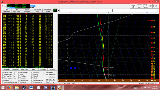
Today was warmer than its been, but the warmth will not stick around for long. Tuesday has the possibility for snow in North Mississippi and temperatures are going to plummet after the front moves through. I will go through the week through.
300mb
as of 12z monday, Starkville was in the Right front sector of the jet streak which contributed to the clear skies today. The 12z Euro initialization was pretty good, having the same shape as the 300mb upper air chart from the SPC. The GFS initialized too far east. The NAM initialized the same way. By 12z Tuesday on the Euro, the jet rotates, and starkville is in the right rear sector, bringing rising motion. This will become sinking motion as the trough continues to deepen by 6z wednesday. GFS agrees, while the NAM moves just a hair slowing on the trough. Faster movement is likely due to a positive NAO. A trough sticks around through Friday when ridging returns. However, this is accompanied by an upper level low forming over texas, so that will have to be monitored. The GFS brings the next large trough through late Sunday and early Monday, with a jet streak bringing some more rising motion. The Euro shows that same trough, but a little further left and with a much broader jet streak. Overall, both models are showing good rising motion for Tuesday and for sunday night/monday morning.
500 mb
the 12z Euro does not show much vorticity advection until the afternoon Tuesday. Both the GFS and the NAM are showing similar stories to that. There will not be much PVA to help with this system until the afternoon. We get some sinking motion due to NVA on wednesday. The euro shows our next PVA will be on Friday with some weak rising motion, but it does not look too impressive. It is swiftly followed by NVA during daytime Friday, so I do not expect much from that. We get some minor PVA Saturday evening into night too associated with that upper level low, with more possible on Monday depending on how low the trough digs(it is negatively tilted, so it is unlikely to cause much here based on its location in the northern Midwest). GFS shows the vorticity sticking around longer on Friday and Saturday. Still going with NVA because the winds are a little too westerly to bring the stronger PV to starkville, but I expect things to be more clear soon as this is still a while out.
850mb
Morning tomorrow, The Euro has very slight warm air advection from a WSW wind coming from texas/the gulf. It is not particularly impressive by itself, but it is bringing more moist air in from the gulf. CAA sets in soon after as the winds turn to a westerly direction. The GFS is a little more pronounced on the WAA than the euro, though that may be due to the color map (My color vision isn’t the best, so the maps can be a little hard to interpret). WAA returns on friday, bringing some rising motion. Both the Euro and the GFS show this. WAA remains through the weekend.
700 and rising motion:
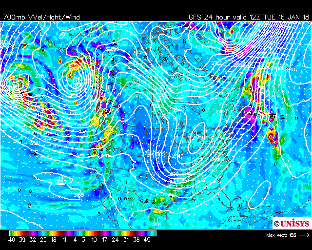
There will be plenty of rising motion in starkville tomorrow due to initial Warm Air Advection and the Right Rear quadrant of the jetstreak. This is good for our precip chances and the direction of the 850 wind is good for getting moisture into our middle atmosphere. GFS 700 chart also shows good rising motion Sunday night.
Precipitation:
And here’s where things get tricky. All the models agree with precipitation, but they all disagree with the precip amount. Even minor fluctuations in moisture or snow ratios can take starkville from having a dusting to over an inch. Let’s get into what each model is seeing, and what we are seeing from the system currently in Arkansas and Missouri.
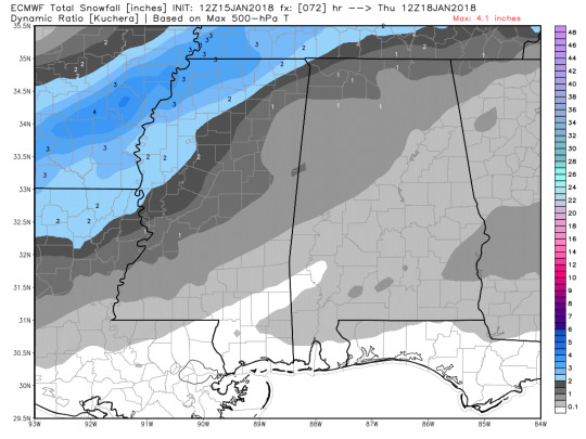
Currently the 1/15/18/12z Euro is running drier than the 1/15/18/00z Euro. The 0z was running about .1″ of QPF here, while the current one between .05″ and .08″. Euro predicts a little less than an inch on sunday night. Above is the Kuchera Ratio map from the Euro. It says about .8″ to 1″.The GFS is showing about .05″ to .08″ of QPF for starkville tomorrow. It is a lot drier for Sunday, only showing .1″. The 3km NAM has really dried out for tomorrow, showing less than .05″. 1z HRRR showing much of the same, about .04″. EPS ensemble mean for snow is around half an inch. The tricky part here is the mesoscale models have not gotten the radar initialization accurately. Additionally, the snowfall has over preformed in Missouri and Arkansas. For instance, the 12z euro has around 3 inches near New Madrid, but a trained spotter recorded 11 inches. There is also a problem with moisture from outside the model domains being advected in. GOES-16 shows mid level moisture being advected in from Mexico and the gulf. Overall, I think the system has the potential to over-preform the models. It has done so already in Missouri, but a lot right now depends on if the moisture from mexico reaches mississippi by the start of the event. Right now I’m going to be conservative and say that starkville will get 1-1.5 inches of snow, though that is subject to change and I will definitely get back on this.

Temperatures
Starkville will get quite cold Tuesday night as temperatures fall into the lower teens. Snowfall could skew this number even lower, possibly into single digits. The bigger problem is wind chill.
TUESDAY:
Snow 1-1.5″, Temperatures falling throughout the day. High of the daytime being around 27F, falling to 24 in the afternoon. Nighttime low around 13 F, possibly into single digits with fresh snow. Wind around N10-15mph. Wind Chills Below 5 F.
Wednesday:
Clear. High around 28F possibly lower due to snow, Wind around NW 5 mph, Low around 19F.
Thursday:
Sunny high near 40. Low near 26F.
Friday:
Sunny, high near 48F. Low near 36F.
Saturday:
Partly Cloudy, High near 56F, low near 47F.
Sunday:
Cloudy, High near 59F, Low near 45F. Overnight rain possible.
0 notes
Photo

It’s been a chilly past couple of days here in Starkville due to cold fronts and an upper level trough. I plan to see if this chilly weather will persist and judge on when our next shot at rainfall is.
300 mb:
Currently, an upperlevel trough is sitting over the NE United States. This will exit the us by early Saturday morning. The biggest thing to note on the Euro is the presence of a shortwave trough that is moving across the northern half of the country. This brings no threat to Starkville, but it will be a problem for areas to our north like Illinois, Indiana, and Ohio. They will be experiencing initial sinking motion due to a right front region of the jet streak which will transition to rising motion from the right rear quadrant. Illinois and Indiana appear to have more of an issue due to this because they’ll still likely have daylight by the time the right rear region moves over, but the risk still exists for Ohio.This jetstreak moves through on Saturday. A smaller jetstreak along the shortwave also moves through on Sunday with much the same as above. GFS shows the same for the midwest. Shortwave trough bringing a series of jetstreaks. GFS shows more ridging than the Euro does after the shortwave passes through. Euro is showing a more pronounced trough and ridge on wednesday as the next trough sets up over the northern US, but it’s jetstreaks seem far less impressive than the GFS’s.

Up to that point, the models agreed pretty well, but they disagree on the placement of the troughs by friday, and they have swapped on what they are thinking. Yesterday(as of writing), the Euro was showing more activity here, but the trough placement just isn’t conductive for anything through next friday. However, the GFS shows the trough moving through much faster. The GFS also has starkville in a Right Front region around morning Friday, with a transition to Right Rear by friday evening. I am not too sure which is more valid at this moment. The NAO is marginally positive and is forecast to oscilate between negative and positive for the next week or so. A + NAO would me the GFS is more valid and we have a better shot at rising motion on friday, whereas a - would be more likely for the Euro to be right(though the euro tends to back up in the west long range anyways). I will hesitantly trust the GFS right now should NAO conditions hold, but I expect the models to continue switching as we get closer. Another couple of days should make the picture way more clear. (GFS seems to be more of a day event, Euro a night event ~ 6-12 hours later).

500 MB:
The 500 is showing a lot of the same as the 300 as far as positioning. It still has the shortwave entering the midwest by sunday. The midwest will have plenty of PVA as the trough moves through. The set up looks pretty good up there on both models. Ohio has the least PVA and Illinois gets the most. I expect plenty of rising motion there for that reason. Starkville actually has some really minor PVA on sunday as well, but it is pretty negligible compared to the midwest. NVA sets in here by monday night, so it should clear out by then in the midlevels. Starkville gets some more PVA on wednesday with the second trough that moves through, but only the euro is picking up on that. some more brief PVA on thursday. The line of vorticity looks more impressive magnitude wise here, but it seems a bit detached from any major shortwave or longwave. The GFS is showing more impressive PVA from the major trough right now, but the majority of the vorticity seems to go through the midwest, so PVA probably won’t be as big as WAA(which I’ll get to in a second).
850mb
The shortwave in the midwest will have WAA on sunday during the early afternoon. This will turn into CAA by late evening, so that may inhibit late forming storms, especially in North Illinois. Starkville will have some WAA on thursday, perhaps allowing a few showers. The Euro also shows ample WAA for when it has the trough digging through our area. This shows me that this will be a WAA driven system. The GFS shows much of the same, albeit 6-12 hours than the Euro for the friday system. There should be a decent amount of rising motion due to warm air advection.
700 mb:

700 chart shows about what I expected for the GFS. It shows a decent amount of upward vertical velocity.
Overall, I think we have a decent chance of rain next friday due to the trough that will be moving through. It will be mainly WAA driven. I think it is too early to call anything other than rain right now, but I will keep an eye on it as the week progresses. Rain chance also exists for thursday as there seems to be plenty of moisture available and some weak rising motion.
0 notes
Photo
There’s a cold front coming through this weekend and will bring us some below average temperatures as well as a possible freeze. The above chart is the initialized mslp for the 12z euro. It is showing the low being centered around eastern Wisconsin. This low will have a cold front associated with it that will bring pretty significant temperature change. I plan to go through the 300, 500, 850, 700, and surface(precip and temperatures)
300:
Above is the 300mb chart 12z for the Euro. It shows the trough a state behind the surface at that time which is pretty typical of these sorts of systems. The trough is lightly positively tilted, but the top of it looks almost vertical. Mississippi and alabama aren’t really in a jetstreak at that time. At 6z saturday, the trough seems to have broadened slightly, with the center now over North Wisconsin, though the distance until the next contour line south is rather large(the next line is in Missouri). Mississippi will begin getting some rising motion due to the right rear of the jetstreak. We enter the left rear of the jetstreak shortly after 12z saturday. That will bring us sinking motion. For the rest of saturday, the trough digs in a little bit, but begins to lift up the east coast by the beginning of the work week. The southern part of the trough that goes up the coast appears to break off from the larger circulation around that time. By tuesday 0z, that wave has mostly dissipated and a jetstreak runs from Nebraska to NY. Oklahoma and Vermont should see the greatest rising motion from this streak. This streak extends a lot during the night and extends Iowa into Canada by dawn Tuesday. The Euro shows a trough for most of the week with some shortwave features here and there. GFS has the trough positioned similarly at 12z Friday. It has a few more contours but the 900 height line is roughly in the same location at 6z Saturday. It has the streak a little further east than the Euro does however, so that would imply a quicker onset of rising motion. GFS has the trough tracking up the coast a little faster and a little longer than the Euro does. It also has the position of the jetstreak a little further north so Nebraska gets more rising motion, and it appears to have it a little stronger than the Euro. It has the flow being more zonal for the rest of the week.
500:
The Euro and the EPS are both showing a good sized trough over the midwest at 12z fri. Mississippi has some PVA starting around 0z saturday and that general strengthens through the night. As a whole, the euro has starkville having PVA throughout the day until about dinnertime on saturday, so there should be some pretty good rising motion due to that(though that’s only one variable, the jetstreak and CAA will take care of rising motion after they move in). All the positive vorticity will be gone from mississippi by sunday, though the eastern coast will have some pretty good PVA from the trough by that point. For the rest of the week, looks like there will be some PVA later in the week around wednesday or thursday, but the trough doesn’t look too impressive so I would be hesitant to expect much from that at this point. Looks to be fairly quiet once we get past Saturday. The GFS shows a similar story with the vorticity advection for tonight, once again just a little bit faster than the Euro. First PVA should be here mid afternoon followed by minor NVA and then PVA through the night(a small line of PV shows up over Starkville at 0z sat, Euro didn’t pick up on this as much). PVA should end by sunday 0z. The east coast still gets plenty of PVA beginning sunday afternoon, looks like they should have plenty of rising motion from this system. GEFS shows decent agreement with the deterministic model for the next couple of days, then becomes very zonal for the rest of the week, possibly due to members disagreeing(the deterministic 300 does show zonal flow though).
850 mb


Euro shows(from what I can tell on this chart, the color scale is a bit cluttered) some WAA from the gulf in our area, not looking super great but it is there. GFS also shows some WAA at this time. CAA is very noticeable out to the west into Arkansas. 0z, the Euro shows that CAA reaching the Mississippi river and Delta, east MS still has WAA. This is also seen on the GFS, though this is a little further into the state. We will start experience that CAA from the front by 6z saturday, which will inhibit rising motion. We will get some WAA after the trough leaves, with decent WAA by monday 6z. GFS looks pretty similar to the Euro, perhaps a little bit faster but generally similar. We experience some more WAA near the end of the week, but the trough still doesn’t look particularly impressive to me. Still, some rising motion expected from that.
700:
GFS shows pretty good upward vertical velocity at 0z. This makes sense since there will be WAA, right rear quadrant in the jetstreak, and PVA. 12z doesn’t look like the same map as the other 3, but I don’t expect much rising motion left in mississippi by then since the CAA will have set in. East Coast will have Saturday Night through Sunday morning. Euro shows pretty good RH at 700, but they don’t have a 700 VV chart that I could find, but I would assume it lines up pretty well since both models have been pretty similar today.
SURFACE AND MISC.
Overall, there is definitely a cold front moving through mississippi tonight. That will bring some much needed precipitation and some much cooler and potentially freezing temperatures. I’m gonna format this section a little differently than my other paragraphs since I want to put this in a seven day format. Using Bufkit for the values and estimating the values from the Euro
Fri Night and Saturday:
Friday Night, definitely expect rain. There is sufficient rising motion and moisture, and the Euro predict s about a half inch of rain. GFS predicts about an inch. Rain Between 0.5″ and 1″. Winds out of the SW at 15-20 MPH shifting to the NW at 15-20MPH. Nighttime low of 40 F. Daytime High near 52 F. Clouds clearing out
Sat Night to Sun:
No Precipitation, limited clouds. Winds NW at 15 MPH. Low near 33 F. High near 55 F
Sun Night to Mon
No Precip, Clear. Winds light. Low near 35 F. High Near68 F.
Mon night to Tues:
No Precip, Mostly Sunny, Low near 44 F, High near 66 F
Tues Night to Wed:
Precip 20%(via mos), PC, Low near 50F, high near 70F
Wed Night to Thurs:
Precip 40%, MC, Low near 60F, high near 75
Thurs Night to Fri:
Precip 30%, MC, Low Near 63, High near 74.
0 notes
Photo
It’s been a nice week here in Starkville, but the temperature has climbed to above average for late October again. This will change next week as a cold front moves through this weekend.
Initialization:
For 12z, the GFS and NAM initialized the ridge east of the actual location. The Euro is also a bit east of the actual location.
300 mb:
At 12z friday, the Euro shows a ridge over the SE US(which is contributing to our current above average temperatures). This trough digs into the central US by 12z sunday. by 12z monday, the trough is becoming cut off over Arkansas and Louisiana. At this time, Starkville has some rising motion due to a jetstreak, but the streak is rather weak. 06 tueday, Starkville will be in a right front quadrant of the jetstreak, showing sinking motion. A weak ridge builds in by midday thursday, though it is sandwiched between two troughs. The GFS has the trough propagating into Oklahoma a little slower than the Euro does, but it’s not much slower. Interestingly though, it has the trough go further east than the Euro does by 12z Monday, so it appears to pick up some speed between OK and AR. Starkville still experiences some rising motion from the jetsreak(still weak), but the sinking motion on Tuesday does not develop until later in the day. The GFS has the cut off trough get completely absorbed by the larger, longwave trough. Ridging returns by 12z Thursday, albeit still between two other troughs(the eastern trough is a little further south and offshore vs the euro, and the western one is more positively tilted on the GFS). The trough moves in a bit further south on the NAM versus the global models. It appears to be over Texas by 12z Sun(though the colors make it a little difficult to read). It has the trough going way slower than the other two models. It is centered over NE Louisiana by 0z Tuesday(the furthest hour out it goes right now). Overall, I expect a big trough going through the united states the weekend. It should reach the starkville area by tuesday, and we will have rising motion from the jetstreak on Sunday night/monday morning.
500:
The Euro shows the trough in the central US by 12z sunday like the 300 chart. 12z monday, the bottom trough(split from the upper trough by now) is over Arkansas. This will bring starkville plenty of PVA and rising motion late sunday and monday. This persists until early afternoon monday when the trough will be centered over mississippi and we start getting some NVA(aka sinking motion). We do start getting some more PVA on tueday morning after the upper trough absorbs the lower trough and digs south. This is followed by NVA and eventually ridging on thursday. The GFS hows the PVA moving in earlier than the Euro does, about 0z monday. It has us reaching maxima vorticity around the same time as the Euro does however. It continues to go east and we undergo NVA and sinking motion. GFS also shows the second trough pushing down(and bringing more PVA) and eventual us returning to ridging. The NAM also shows some PVA on late monday/early sunday, but it still has the low much further west than the other two models. Overall, expect rising motion late sunday and monday morning, followed by more (brief) rising motion associated with the second trough on Tuesday.
850
The Euro shows some WAA in starkville as early as Saturday morning as the winds shift to bring in gulf air. Sunday evening, still have air moving in from the gulf, still have WAA. There should be plenty of rising motion due to that on Sunday night/monday morning. 0z monday(19 CDT), CAA is pushing into Louisiana and Arkansas, likely due to a cold front. We begin to get CAA between midnight monday and 5 AM monday. We continue to get further CAA and sinking air until wednesday when the trough begins to lift out and WAA behind the cold airmass. The GFS also shows the winds shifting to the South like the Euro does, so it also shows the WAA beginning saturday as the warmer gulf air is advected in. It still has the system moving in faster, so this transitions to CAA earlier than it does on the euro, between 0z and 6z Monday(about 6 hours earlier than the Euro). There is very brief WAA 6z tuesday before it becomes CAA and the cold airmass pushes in. It shows WAA on Thursday as the airmass moves out. The NAM still shows the WAA starting on Saturday as warm air comes up from the gulf. The NAM does not show much of a pattern shift at all from that initalization, it does not have the front moving in before it is out of range for the model.
700

This is the unisys 700 chart for 00z monday(19 CDT). It shows plenty of upward vertical velocity available at that time on monday. This makes sense since the GFS showed plenty of WAA and PVA during that time. The NAM is not showing that VV during that time, but it has been having the system move in late consistently between all levels. Cloud wise, the euro 700 RH shows quite high RH levels for sunday night/monday morning, so that is good for mid level clouds. Overall, the GFS and Euro are showing good ingredients for upper level clouds and rising motion.
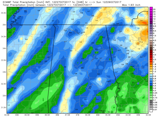
Precipitation
note: picture is meant to show the total rain, data is for tuesday 2am(post event)
At this point, I am fairly confident that starkville will see rain Sunday night. The beg question right now is when will it get here? Well, the GFS is running about 6 hours faster than the Euro on this system, and it shows good rising motion available at 7PM on sunday(from the PVA and WAA). The Euro shows higher 6 hour QPF values starting around 7PM Sunday, while the GFS has it around the same time. However, bufkit GFS shows the rain starting around 3PM. Overall, I expect the rain will begin late afternoon sunday, with heavier rain beginning around 7PM to midnight. Monday itself looks like a rather dreary day, with a steady rain according to the 12z GFS. GFS has total rain at just under 2 inches for the whole event, so I’m going to expect to see between 1.5 and 2 inches of rain for sunday and monday. (the euro also roughly agrees with those numbers even if it is a little behind on the timing).
0 notes
Photo
300 mb
The GFS, NAM 12KM, and Euro all have a jet streak over the state of Alabama. Alabaster is in the right entrance region of the jetstreak which implies rising motion. There is a longwave ridge over New England and Canada. This is being followed by a trough that is over California and Orgeon. At 12z Thur, the trough becomes a little more broad and a ridge follows behind in Canada.The New England ridge is completely broken up by a trough in Canada. The models have the trough pushing through the country and it will begin to lift from Iowa into Canada by Saturday Midday. Another trough digs in monday. The Euro has that trough digging in faster and stronger than the GFS. The Euro has Alabaster in the right entrance region of a jet streak, causing rising motion.
500 MB
Alabaster has some PVA as winds are from the east at the beginning. This shows up on all 3 models. There is still some PVA and rising motion by morning on thursday. NVA sets in shortly after and causes some sinking motion. THe trough lifts before it can advect any vorticity into alabama on all 3 models. The biggest question on Saturday is the placement of the tropical depression. The GFS shows it hitting around New Orleans while the Euro shows it hitting the florida panhandle. The GFS would cause a much more significant impact for Alabama, but it all depends on the placement and strength of the trough. The Euro has done a bit better this season for hurricane track, so I would be more inclined for a more eastern track right now, but it could still easily drift west.
On Sunday Morning during the projected landfall, both models have a longwave trough in the NW united states. The euro has it further south and east than the GFS, and a bit stronger. This trend continues with the Euro being consistently further south and east of the GFS. The Euro has PVA beginning to enter west alabama by 0z wednesday. This would bring rising motion and is definitely a system to keep an eye on for next work week.

850 mb:
Today, Alabama has sinking motion due to cold air advection. This is seen on all 3 models. the models disagree with each other a little bit on thursday morning. The NAM has some very minor WAA, causing rising motion, but the Euro and GFS show very weak gradients and minimal if any temperature advection. WAA starts to develop over alabama on friday evening as winds start to move in from the south. This is seen on all 3 models. This WAA advection continues until the tropical system moves out of the area. The GFS has the air over the gulf cooling down on Tuesday, which will bring CAA to alabama and mississippi. The Euro has CAA much quicker, by monday 12z. The Euro also has some WAA advection ahead of the cold front on Tuesday. I will make another post later this week as we get closer to that event.
Overall, This is a very tricky forecast since all the systems are 4-7 days out. Currently, I am feeling a little more confident in the Euro for the hurricane track since they have had a better record this year and the ensembles seem to agree a little more than the GFS(from what I saw). I feel confident in a cold front going through Mississippi and Alabama next week. The Euro has it going through on Tuesday, while the GFS has it coming through later in the week. There is plenty of rising motion for storms with PVA and WAA on Monday and Tuesday, so I would definitely take that in account, but I would feel a lot more confident if I was seeing this 3-4 days out instead of 6-7. I will make another blog post later this week as we get closer to that. That should also let us get a good idea on which model is working better on this system.
0 notes
Photo
For this week’s forecast, I’m gonna be focusing on Auburn due to the football game on Saturday the 30th. For this forecast, I’m mainly going to be comparing the Euro with the GFS. As of forecasting, weatherbell has not updated with the 0z Euro, so this will be comparing the 0z GFS and 12z euro
300 mb
The Euro Model seems to have initiated pretty well on trough and ridge placement for the most part. The observed map does not have the ridge pushing into Alabama before falling into a shortwave trough. This Euro had that closing off by 00z, and the observations roughly aligned with that. The GFS is doing better with the gulf low than the Euro is both position wise and shape wise. After 0z, the GFS has the gulf low moving further south, roughly due west of Cuba by 0z Sunday. Around that time, the GFS has slight longwave ridging to the west and north of Alabama into Mississippi and Tennessee. The upper level wind should be roughly due west. At the same time, the euro has the 960 line in roughly the same location as the GFS, but it is a little less steep. The euro is showing less lines of height, but the lines that it shares with the GFS do roughly match up.
500 mb:
At 0z, the Euro has the wind in western Georgia curving further south than the GFS does. At that time, the Euro has no positive vorticity over the Auburn area, but the GFS does. Therefore, the GFS has some NVA at the time of initialization. GFS continues to show ridging over the next 24 hours with minimal vorticity advection in auburn after the initial NVA. Overall, GFS shows sinking motion over Auburn for gameday. The Euro is also showing ridging and minimal vorticity advection. The Euro also shows the low in the gulf moving slower than the GFS does. I expect sinking motion due to ridging and minor NVA.
850
The GFS 850 shows little if any temperature advection at initialization. However, there is WAA advection to Auburn’s south, so that would cause some rising motion. The Euro has the warm air covering a broader area, so it implies some CAA, and therefore some sinking motion, in Auburn’s area. Colder air digs in on both models over the next 24 hours. Both show weak CAA around the football game’s kickoff (23z Saturday, 18 CDT). This shows generally sinking air over Auburn and SE Alabama tomorrow.
700
The 700 chart was the trickiest part of this as it didn’t really seem to agree with the rest of my analysis. The NAM appears to show minimal to sinking motion over auburn, but the GFS showed minor rising motion. I do not agree with the GFS putting an area of rising motion in central Alabama. There is minimal air advection, and what is there tends towards cold air advection. There also is no vorticity advection, so I do not know what is causing this rising motion. My only idea is they are barely in a right rear quadrant of a jet streak, but it is not really that impressive there.
Overall, I think it is going to be a nice fall day for Auburn on Saturday. Dewpoints at the surface and aloft are down due to a recent cold front, so cloud cover should be minimal. GFS raw is showing temperatures around 75 an hour after kickoff; mos shows it being 76. I expect it to be about 77 around kickoff.
0 notes
Photo
Sorry for the bad quality of the picture above, my browser crashed and wiped all my work so that’s what that is.
500 MB: Starkville currently under an upper level low. This will bring some PVA until Sunday. After that, it will bring some NVA as it leaves the area. The next vorticity advection will come on Friday Afternoon and positive vorticity gets advected into the area. That will cause some rising motion that afternoon when combined with the jetstreak. It looks like this system will be more of an issue north of Mississippi into Tennessee and Kentucky where they have stronger PVA. GFS continues to show a much weaker and further north trough versus the Euro, which would cause problems along the Carolina coast as Maria is brought closer to the shore.

850mb: There is currently not much temperature advection over Mississippi according to both models. The Euro has fairly weak WAA on wednesday, but the winds are fairly variable in Mississippi. Throughout the week, the 850 shows a pretty tight gradient between cold and warm temperatures, representing a cold front advancing through the country starting around Colorado/Nebraska on Sunday. By the time it reaches Mississippi on Friday, the gradient is a lot less impressive. The wind direction suggests mainly CAA for starkville on friday. The GFS shows CAA as well, though weaker than the Euro.
700mb: Relative humidity values aren’t looking to impressive over Starkville on Friday. This suggests less rising motion. This is due to cold air advection overpowering weaker PVA. The greatest RH at 700 appears to be from kentucky to new york.
Overall, it looks like it will be another hot week ahead for Starkville, but the rain chances seem fairly slim due to sinking motion and lower upper level humidity.
0 notes
Photo
Hurricane Irma is currently a strong category 4 hurricane. It has sustained winds at 150 mph and a central pressure of 927 mb. Its highest sustained winds were 185 mph and it sustained that for about 36 hours. It stayed a category 5 for about 3 days before weakening this morning. It has already caused massive destruction to several islands, including the island of Barbuda.
Currently, the national hurricane center has Irma making landfall around the Florida keys, which is a westward trend compared to yesterday’s models. The model ensembles for the euro and the gfs both agree on this, so it is very likely that Irma will make around there. This puts Miami on the front right side of the hurricane, so eastern Florida will likely have some brief tornadoes alongside the wind and rain from Irma. The 12km and 3km NAM have absolutely crazy high values for STP and shear, but the NAM doesn’t usually do to well with hurricanes so I don’t expect conditions to be as crazy as those models suggest. The GFS shows enough instability and shear to generate some tornadoes, so anyone in eastern Florida definitely needs to keep that in mind.
Irma is also going to bring a lot of rain to the southeast, but it will not be as extreme as hurricane Harvey. Some places in Florida may get as much as 12″ of rain by Tuesday. Storm surge could also be up to 12′ in some areas of South Florida.

I got the last picture from http://spaghettimodels.com/
EDIT: 11PM CDT.
Irma has restrengthened into a category 5 hurricane.
0 notes
Photo

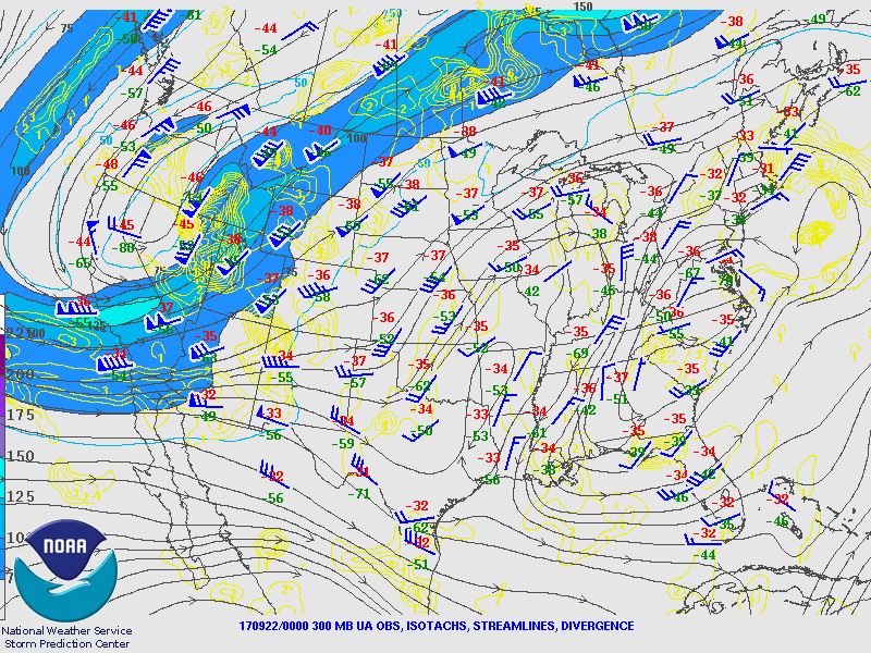
8/31/2017
250mb: A shortwave trough over LA and TX will propagate to MS by tomorrow morning. Another shortwave develops this weekend over TX, but it’s effect seems to be relatively minor for MS. Tuesday, a longwave trough picks this up on tuesday, and a jetstreak develops shortly after. On wednesday, starkville is in the right rear quadrant, so I expect rising motion in the area on Wednesday.
500mb: The weekend Shortwave trough is visible on the 500mb chart, but it starts off less pronounced. As the ridge breaks down, the shortwave becomes an inverted trough ~0z on Tuesday. It does get picked up by the longwave trough on wednesday as with the 250. There is some PVA as harvey moves through, which will switch to NVA after after Harvey passes through. There is a relatively high amount of cyclonic vorticity in Starkville and central AL mid morning Tuesday, but the winds diverge due to the longwave trough and the inverted shortwave. That leads to Starkville getting some NVA from winds going into the longwave trough, and we are giving PVA to the areas to our east and west due to how it set up. There is more PVA on wednesday as the longwave trough digs into NE MS and AL.
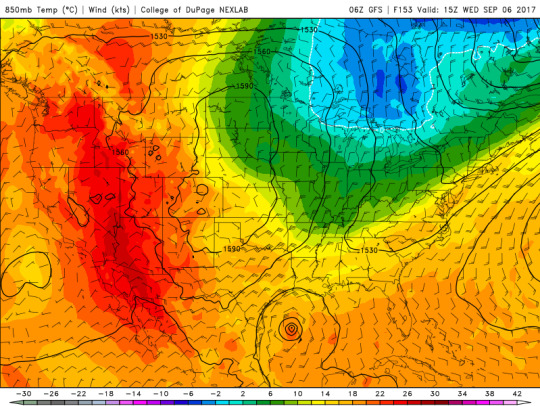
850mb: There is not a lot of temperature advection with Harvey. There is some cold air advection on wednesday as the Long Wave upper air trough moves in. The gradient from Starkville to extreme SW KY is about 6 degrees C. This suggests a cold front moving into the area.
Precip: Rain today will be widespread in the morning and scattered this afternoon due to Harvey. I expect rain chances to go up around midweek as that trough digs in. Starkville will have some rising motion due to the jetstreak on wednesday. Due to this and the CAA advection, there will be a cold front that moves through on Wednesday. This drops the temperatures quite a bit for next Thursday. The actual surface low appears to be in Canada on wednesday.

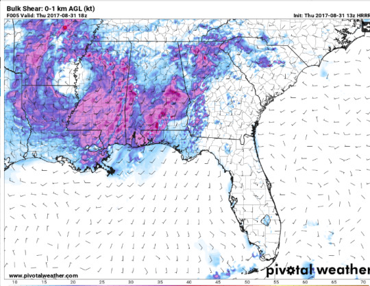
severe: The SPC has Starkville in a slight risk today, and tornaodes are possible. Wind is from the SE at the surface, so that is favorable. The cape at 18z is going to be about 1500, so that is also pretty good for tornadoes. 1KM shear is 21 knots, so that is not too bad for tornadoes.
NOTE: I wrote this early this morning and there is a delay between writing and posting.
0 notes
Photo
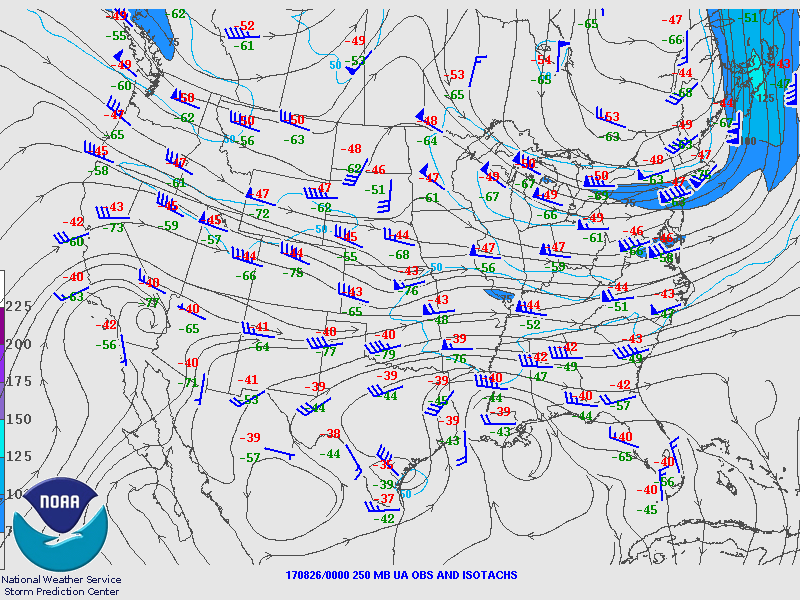
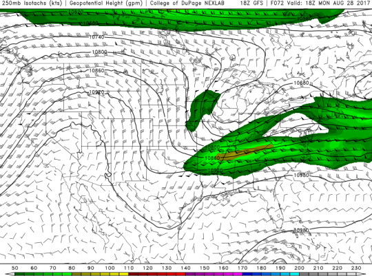
Good Evening everyone! The eastern US is currently under a trough, but a ridge is developing behind it. That ridge should build in over North Michigan and Wisconsin around 21z on Saturday 8/26. After that, a trough builds down further south around 0z Monday and will be around through midweek. Additionally, there is convergence in the upper level winds over central Alabama into Georgia.
Around 850mb on Sunday at 0z, the winds as far east as Alabama appear to be be flowing cyclonically around hurricane Harvey in Texas, but there is not much temperature advection in the southeast. The GFS suggests that the winds will be mostly easterly in Alabama at 850 mb through wednesday when the winds will shift more southeasterly.
For this weekend, Alabaster should be fairly dry. The mean sea level pressure should be around 1018mb on Sunday morning, which suggests high pressure in the area. The GFS suggests some isolated pop up showers Monday morning through Tuesday, but it appears to be typical summer hit or miss type rain. Rain picks up south of Alabaster Tuesday afternoon as rain possibly associated with Harvey begins moving into Florida. More widespread rain seems possible on wednesday afternoon, but there does not seem to be a front associated with this as there is not any temperature advection or any midlatitude cyclones.
Temperature wise, it should be a little below the normal 90 F. Saturday’s high should be around 87 degrees, and GFS and MOS for Calera, al seem to agree on that. Saturday’s overnight low should be around 71. Sunday’s high should be about 84, but the GFS and MOS differ a little more on this, and I went with a higher temperature closer to the MOS based on it being more of a typical summer day. Sunday’s low should be about 69 degrees, and the two agree on that. The MOS for Calera suggests highs around the mid 80s for the work week, with it getting a bit hotter as we get closer to the beginning of September. The GFS is suggesting temperatures around the high 70s and the low 80s. I am hesitant to go with those low temperatures because they are so significantly lower than climatology.

0 notes