
Last Seen Blogs

bbuckss
misc

careynco
Just making things

quakesmarvel
katie ۞

sinnoske-blog
제목 없음
careynco
Just making things
Text
DEM SPATIAL RESOLUTION MEAN FOR FLOOD MODELLERS
Flood models reflect an actual land surface using DEM data. The amount of land that each grid cell in a DEM can represent is referred to as its spatial resolution. A grid cell that has a spatial resolution of 10 meters thus represents an actual land area that is 10 by 10 meters. The labels "low resolution" and "high resolution" are relative. A "lower" resolution dataset typically smoothes out topographic characteristics, while a "higher" resolution dataset implies considerably more preservation of land features (Environmental Systems Research Institute, Inc., 2016).

In the hydrological and hydraulic modeling sector, DEM resolutions typically range from 1000m to 2m or less (Vaze, Teng, & Spencer, 2010). Here, we restrict our discussion to the national-scale flood maps from JBA, whose resolution ranges from 30m to 5m.
During the flood modeling process, flood modelers must make many crucial decisions. We research the assumptions made to depict complicated natural phenomena; we gather, validate, and incorporate input data; we create and test models, and we critically evaluate the outcomes. The DEM is essential to this applied and unreliable science. Determining where floods are most likely to cause problems for people and property and estimating how water interacts with the environment depend on high-quality DEM data.
The precision and spatial resolution of the DEM affect the accuracy of forecasts of water depth (Vaze, Teng, & Spencer, 2010).
However, even while increased spatial resolution and accuracy frequently lead to better outcomes, these advantages cannot be taken into account separately, especially when taking into account how numerical flood models function. The physical processes of floods are represented by numerical models using many simulations, which, depending on the size of the area, may number in the hundreds of thousands or more. The higher the geographical resolution, the more complicated the models are, and the more computer resources, processing time, file size, data storage, and cost are required (Environmental Systems Research Institute, Inc., 2016).
The preservation of topographical landscape elements increases with increasing DEM resolution. This offers a clearer delineation of the floodplain, tiny streams, highways, and other restricted flow conduits that have a big impact on outcomes. High-resolution topographical data is becoming more widely available, although it's still not everywhere. These data frequently only cover nations and areas with significant populations and/or economic development. However, it makes sense to invest in them if there is a demand from customers and the market for higher resolution flood data as well as good quality and quantity of data.
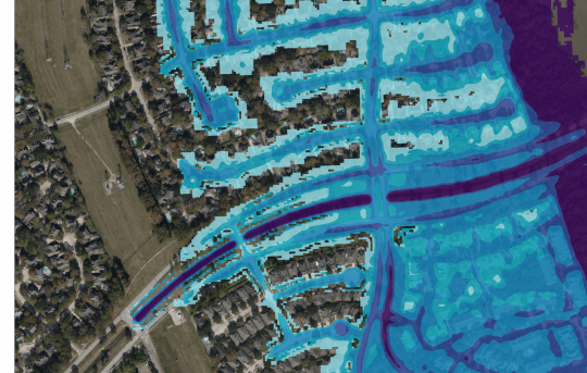
JBA offers 5m-resolution high-resolution flood maps for the US, Continental Europe, the UK, and the Republic of Ireland. Figure 3 shows how the flood maps for downtown Miami have changed as a result of using better-resolution data. The 5m map depicts water movement in intricate urban regions, while the 30m map does not, even if both images show the general areas at risk from floods. The validation of our modeling results using data on past and present flood events support a better, more in-depth understanding of floods from high-resolution maps.
The combination of a number of factors allows us to meet the various requirements of clients despite the fact that flood modeling is a difficult science. Using higher-resolution resources has significantly improved the ability to assess flood risk in locations where we are confident in the quality and quantity of the input data, even if the resolution is not the only criterion for judging the quality of a dataset.
Those with access to the proper knowledge can ultimately make the most intelligent decisions. Speak with us about the variety of data we offer, its potential applications, our bespoke consulting choices, and how to decide which is the best choice for you.
1 note
·
View note