
earth-as-art
Earth as Art
Daily photos and images of the Earth
1791 posts
Don't wanna be here? Send us removal request.
Last Seen Blogs

shiftersam
Sam Evans

plantagodelendaest
Animated 3d plant

itzsana-kiddingmenow
.・your loss, babe~.・

elclassico110
Elclassico

ivyboyinlace
Ivy's blog. She/Him
Photo
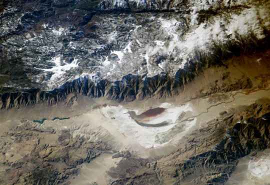
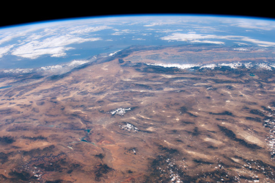
Southern Sierra Nevada and Owens Lake
Astronauts aboard the International Space Station looked obliquely down at the steep eastern flank of California’s Sierra Nevada. Even from space the topography is impressive—the range drops nearly 11,000 feet from Mt. Whitney (under cloud, arrow), the highest mountain in the lower 48 states (14,494 ft), to the floor of Owens Valley (the elevation of the town of Lone Pine is 3,760 ft). The Sierra Nevada landscape is well known for deep, glacially scoured valleys, like Kern Canyon west of Mt. Whitney.
The California landscape changes east of the Sierra, marked by alternating steep desert mountain ranges and valleys. Many of the valleys contain dry lakebeds, remnants of deep lakes that filled the valleys 11,000 years ago, at the end of the last ice age. Owens Lake was a salty lake until 1913, when the Owens River was diverted into the Los Angeles Aqueduct, quickly draining the lake. Today, Owens Lake is a dried salt flat that contains some pooled water following rains. Solar evaporation ponds lie along the northern edge. The bright red color in the wet parts of the lakebed is from the red color of salt-loving bacteria (halobacteria).
For more information about halobacteria, read Why Owens Lake Is Red!
Astronaut photograph ISS006-E-24783 was taken February 6, 2003, with an Electronic Still Camera equipped with 180 mm lens and is provided by the Earth Sciences and Image Analysis Laboratory at Johnson Space Center. Additional images taken by astronauts and cosmonauts can be viewed at the NASA-JSC Gateway to Astronaut Photography of Earth.
Instrument(s): ISS - Digital Camera
23 notes
·
View notes
Photo
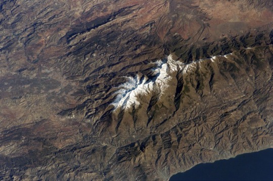
Sierra Nevada, Spain
The Sierra Nevada, part of the Betic Cordillera of southern Spain, were formed during the Alpine Orogeny, a mountain-building event that also formed the European Alps to the east and the Atlas Mountains of northern Africa across the Mediterranean Sea to the south. The Sierra as observed today formed during the Tertiary Period (65 to 1.8 million years ago) from the collision of the African and Eurasian continental plates. The former Tethys Sea also closed during this time period; the Mediterranean Sea is the largest surviving remnant basin of the ancient Tethys.
The Sierra Nevada in the Granada province of Spain are perhaps the southernmost skiing location in all of Europe. Veleta Peak, at an elevation of 3,398 meters (11,148 feet) above sea level, is a popular destination for skiers and snowboarders. The rapid transition from lofty ski runs to Mediterranean beaches within a few hours’ drive has made the Sierra Nevada region popular for both outdoor and urban tourism. This astronaut photograph depicts the Veleta Peak region of the range and illustrates the sharp contrast between the snow-capped mountains, adjacent dry lowlands to the west and north, and the Mediterranean Sea to the south.
Astronaut photograph ISS012-E-11144 was acquired December 11, 2005, with a Kodak 760C digital camera using an 180 mm lens, and is provided by the ISS Crew Earth Observations experiment and the Image Science & Analysis Group, Johnson Space Center. The International Space Station Program supports the laboratory to help astronauts take pictures of Earth that will be of the greatest value to scientists and the public, and to make those images freely available on the Internet. Additional images taken by astronauts and cosmonauts can be viewed at the NASA/JSC Gateway to Astronaut Photography of Earth.
Instrument(s): ISS - Digital Camera
24 notes
·
View notes
Photo
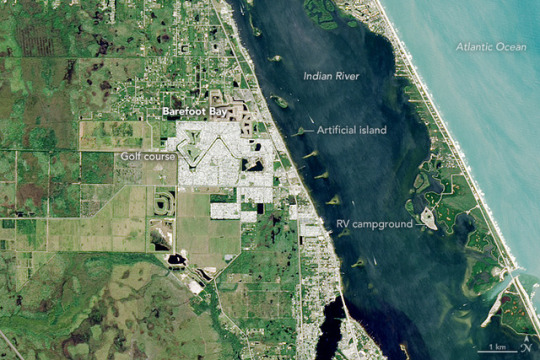
A Haven For Snowbirds
Every winter, more than one million people from Canada and northern parts of the United States, many of them retired, head to Florida to escape the cold. These temporary winter residents—so-called snowbirds—increase the state’s population by roughly 5 percent.
Many snowbirds end up staying in communities like Barefoot Bay, one of the largest communities of manufactured homes in Florida. Established in 1969 in southern Brevard County, Barefoot Bay has a population of roughly 10,000 people, many of whom are drawn to its affordable homes and recreational offerings. Proximity to the Indian River and the Atlantic Ocean gives residents easy access to fishing, boating, and swimming.
On October 22, 2016, the Operational Land Imager (OLI) on Landsat 8 captured this image of Barefoot Bay. With few trees and closely-packed residential neighborhoods, Barefoot Bay appears light gray in comparison to some of the leafier suburbs around it. A drainage canal connects the golf course on the western side of the community with a lake on the eastern side. A mixture of farmland and pastureland (light green), undeveloped land and nature preserves (dark green), and suburbs (gray) surround Barefoot Bay. The developed barrier island east of Barefoot Bay is an RV campground popular with snowbirds.
Note the difference in the color of the water in Indian River and the Atlantic Ocean. Watersheds adjacent to the Indian River have undergone significant development in recent decades, so the river absorbs significant inputs of nutrients, sediment, and other substances from septic tanks, farms, lawns, city streets, and other sources. This can change the clarity of the water, and in recent years, elevated nutrient levels have led to several large algae blooms.
The line of islands in the Indian River were created when the area was dredged in the 1950s to make the Atlantic Intercoastal Waterway. The spoils were used to form 137 different islands, which are now managed by the Florida Department of Environmental Protection and used for wildlife conservation, educational programs, and recreation.
References and Further Reading
Barefoot Bay (2017) Home Owners Association. Accessed December 20, 2017.
BLT (2017, February 17) 30 Things You Probably Didn't Know About Snowbirds. Accessed December 20, 2017.
Florida Department of Environmental Protection (2017) Spoil Island Project: History. Accessed December 20, 2017.
Orlando Sentinel (2017, February 17) Central Florida churches give thanks for snowbirds. Accessed December 20, 2017.
Smith, S. & House, M. (2006) Snowbirds, Sunbirds, and Stayers: Seasonal Migration of Elderly Adults in Florida. The Journal of Gerontology, (61) 5, 232-239.
The Christian Science Monitor (2017, May 4) Population boom creates environmental consequences in Florida lagoon. Accessed December 20, 2017.
NASA Earth Observatory image by Jesse Allen, using Landsat data from the U.S. Geological Survey. Story by Adam Voiland.
Instrument(s): Landsat 8 - OLI
14 notes
·
View notes
Photo
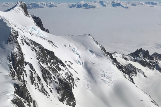
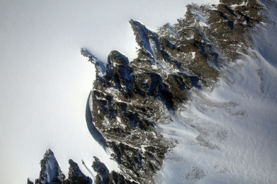
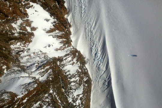
Southern Antarctic Peninsula
After a few hours flying over the Southern Ocean and the sea ice fields around Antarctica, the first sign of land can be startling. The vast expanse of water and ice is suddenly broken by gray and brown rocky mountaintops. Ice pours down the slopes and fills hidden valleys. This is the Antarctic Peninsula, and the ice here is anything but static.
Unlike sea ice, the land ice of Antarctica has the potential to raise sea level. Most of the continent’s recent ice losses have been occurring on its western side, including the Antarctic Peninsula—the strip of land that reaches like an arm toward South America. Research has shown that the southern part of the peninsula is particularly vulnerable, as the glaciers and ice shelves there have destabilized.
To know how much and how fast changes are occurring, scientists must make regular measurements. NASA’s Operation IceBridge airborne mission has been doing just that since 2009.
These photographs were acquired on November 3, 2017, during an IceBridge flight over the southern Antarctic Peninsula. The top photograph, shot by IceBridge project scientist Nathan Kurtz, shows the Creswick Peaks, which jut from the peninsula’s southwestern side, just east of George VI Sound.
The rest of the photographs were acquired that day by the Digital Mapping System (DMS), a camera mounted on the belly of a research plane. The photos show some of the places on the peninsula where ice flows around mountains, and where mountain tops and edges stand out in stark contrast from the snow and ice.
References and Further Reading
NASA Earth Observatory (2016, June 22) Pervasive Ice Retreat in West Antarctica.
NASA Missions (2017) Operation IceBridge.
USGS Geographic Names Information System (2017) Antarctica Detail. Accessed December 22, 2017.
Wouters, B. et al. (2015) Dynamic thinning of glaciers on the Southern Antarctic Peninsula. Science, 348 (6237), 899-903.
YouTube (2017, December 19) Antarctica from Above.
NASA photograph courtesy of NASA/Nathan Kurtz (top) and IceBridge Digital Mapping System (middle and bottom). Story by Kathryn Hansen.
Instrument(s): PhotographAircraft Sensors - DMS
15 notes
·
View notes
Photo
ISS View of the Southwestern USA
This panoramic view of the southwestern United States and Pacific Ocean was taken by an astronaut looking out at an angle from the International Space Station (ISS). While most unmanned satellites view the Earth from a nadir perspective—collecting data while looking “straight down”—astronauts onboard the ISS can acquire imagery at a wide range of viewing angles using handheld digital cameras.
The image includes parts of Arizona, Nevada, Utah, and California, as well the coastline of Baja California, Mexico (image center left). The Las Vegas metropolitan area appears as a gray region adjacent to the Spring Mountains and Sheep Range (both covered by white clouds). The Grand Canyon, located on the Colorado Plateau in Arizona, is visible to the east of Las Vegas, with the blue waters of Lake Mead in between.
The image also includes the Mojave Desert, stretching north from the Salton Sea to the Sierra Nevada mountain range. The Sierra Nevada is roughly 640 km long (north-south) and forms the boundary between the Central Valley of California and the adjacent Basin and Range physiographic province. The Basin and Range is so called because of the pattern of long linear valleys separated by parallel mountain ranges. The landscape was formed by extension and thinning of the Earth’s crust.
Astronaut photograph ISS024-E-14071 was acquired on September 9, 2010 with a Nikon D2Xs digital camera using a 32 mm lens, and is provided by the ISS Crew Earth Observations experiment and Image Science & Analysis Laboratory, Johnson Space Center. The image was taken by the Expedition 24 crew. The image has been cropped and enhanced to improve contrast. Lens artifacts have been removed. The International Space Station Programsupports the laboratory as part of the ISS National Lab to help astronauts take pictures of Earth that will be of the greatest value to scientists and the public, and to make those images freely available on the Internet. Additional images taken by astronauts and cosmonauts can be viewed at the NASA/JSC Gateway to Astronaut Photography of Earth. Caption by William L. Stefanov, NASA-JSC.
Instrument(s): ISS - Digital Camera
16 notes
·
View notes
Photo
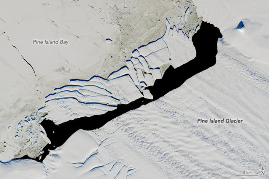
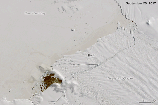
Pine Island Iceberg Under the Midnight Sun
In September 2017, a new iceberg calved from Pine Island Glacier—one of the main outlets where the West Antarctic Ice Sheet flows into the ocean. Just weeks later, the berg named B-44 shattered into more than 20 fragments.
On December 15, 2017, the Operational Land Imager (OLI) on Landsat 8 acquired a natural-color image (above) of the broken berg. An area of relatively warm water, known as a polyna, has kept the water ice free between the iceberg chunks and the glacier front. NASA glaciologist Chris Shuman thinks the polynya’s warm water could have caused the rapid breakup of B-44.
The image above was acquired near midnight local time. Based on parameters including the azimuth of the Sun and its elevation above the horizon, as well as the length of the shadows, Shuman has estimated that the iceberg rises about 49 meters above the water line. That would put the total thickness of the berg—above and below the water surface—at about 315 meters.
This animation combines five Landsat 8 views of B-44 acquired over the past four months.
NASA Earth Observatory image by Jesse Allen, using Landsat data from the U.S. Geological Survey. Caption by Kathryn Hansen.
Instrument(s): Landsat 8 - OLI
19 notes
·
View notes
Photo
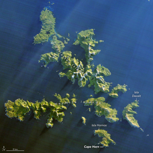
Cape Horn: A Mariner’s Nightmare
Before the opening of the Panama Canal in 1914, Cape Horn was a place that gave mariners nightmares. The waters off this rocky point, at the southern tip of Chile’s Tierra del Fuego peninsula, pose a perfect storm of hazards.
Southwest of Cape Horn, the ocean floor rises sharply from 4,020 meters (13,200 feet) to 100 meters (330 feet) within a few kilometers. This sharp difference, combined with the potent westerly winds that swirl around the Furious Fifties, pushes up massive waves with frightening regularity. Add in frigid water temperatures, rocky coastal shoals, and stray icebergs—which drift north from Antarctica across the Drake Passage—and it is easy to see why the area is known as a graveyard for ships.
On July 12, 2014, the Operational Land Imager (OLI) on Landsat 8 satellite captured this image of Cape Horn and the Wollaston and Hermite Islands.
Hundreds of ships have gone down near Cape Horn since Dutchman Willem Schouten, a navigator for the Dutch East India Company, first charted a course around the Horn in 1616. One vessel that narrowly escaped that fate was the HMS Beagle, with naturalist Charles Darwin aboard. In The Voyage of the Beagle, Darwin described the harrowing journey as the explorers tried to round the Horn just before Christmas 1832.
December 21st. — The Beagle got under way: and on the succeeding day, favored to an uncommon degree by a fine easterly breeze, we closed in with the Barnevelts, and running past Cape Deceit with its stony peaks, about three o'clock doubled the weather-beaten Cape Horn. The evening was calm and bright, and we enjoyed a fine view of the surrounding isles.
Cape Horn, however, demanded his tribute, and before night sent us a gale of wind directly in our teeth. We stood out to sea, and on the second day again made the land, when we saw on our weather-bow this notorious promontory in its proper form—veiled in a mist, and its dim outline surrounded by a storm of wind and water.
Great black clouds were rolling across the heavens, and squalls of rain, with hail, swept by us with such extreme violence, that the Captain determined to run into Wigwam Cove. This is a snug little harbor, not far from Cape Horn; and here, at Christmas-eve, we anchored in smooth water. The only thing which reminded us of the gale outside, was every now and then a puff from the mountains, which made the ship surge at her anchors.
References
Darwin, C. (1845) The Voyage of the Beagle. Accessed December 19, 2017.
The Los Angeles Times (2007, January 5) Cape Horn’s ferocity is terrifying yet alluring. Accessed December 19, 2017.
Outside (2002, August 1) Into the Screaming 50s. Accessed December 19, 2017.
Princeton University Library (2010) Cape Horn. Accessed December 19, 2017.
San Diego Reader (2013, April 11) The World’s Edge: Cape Horn. Accessed December 19, 2017.
Sidetracked (2015, April 23) A Sailor's Nightmare: Cruising Around Cape Horn. Accessed December 19, 2017.
NASA Earth Observatory image by Jesse Allen, using Landsat data from the U.S. Geological Survey. Story by Adam Voiland.
Instrument(s): Landsat 8 - OLI
17 notes
·
View notes
Photo
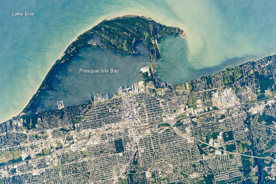
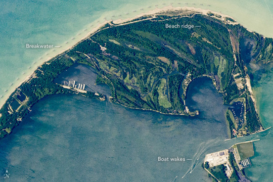
Coastal Spit, Lake Erie
An astronaut aboard the International Space Station focused a long-lens camera on the southern coastline of Lake Erie. The curved peninsula of Presque Isle State Park juts into the Great Lake, while the city in the lower part of the image is the deep-water port of Erie, Pennsylvania. Several V-shaped wakes show boat traffic around the port.
The lake water just offshore tends to be light-toned because significant river and beach sediment is regularly moved eastward by the action of wind and waves. The detailed image shows the swells made by these winds.
Sediment has piled up to build this sand spit over thousands of years. Now covered with vegetation, Presque Isle State Park includes dozens of beach ridges—with each line representing a coastline from the past. The formation of the peninsula also has enclosed Presque Isle Bay, the site of modern port facilities.
Because the sediment is constantly moved along the shore by waves, the exposed beach facing the lake has been protected from erosion. To do this, many short breakwaters (barriers) have been built just offshore for nearly the entire length of the beach.
Astronaut photograph ISS052-E-6364 was acquired on June 21, 2017, with a Nikon D4 digital camera using an 1150 millimeter lens, and is provided by the ISS Crew Earth Observations Facility and the Earth Science and Remote Sensing Unit, Johnson Space Center. The image was taken by a member of the Expedition 52 crew. The image has been cropped and enhanced to improve contrast, and lens artifacts have been removed. The International Space Station Program supports the laboratory as part of the ISS National Lab to help astronauts take pictures of Earth that will be of the greatest value to scientists and the public, and to make those images freely available on the Internet. Additional images taken by astronauts and cosmonauts can be viewed at the NASA/JSC Gateway to Astronaut Photography of Earth. Caption by Justin Wilkinson, Texas State University, JETS Contract at NASA-JSC.
Instrument(s): ISS - Digital Camera
11 notes
·
View notes
Photo
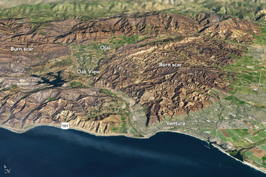
California’s December Inferno
It is rare for large wildfires to burn in California in December, which is usually a wet month for the state. In most years, a few hundreds acres might burn. The 2006 Shekell fire in Ventura charred 13,600 acres, making it the largest December fire in the state between 2000 and 2016.
In 2017, the Thomas fire shattered the record for December and may soon eclipse the worst blaze in any month. After burning for 16 days, the massive fire had scorched 272,000 acres (110,000 hectares or 425 square miles) and was just 60 percent contained. That made it the second largest fire on record in California, trailing only the Cedar fire, which burned 273,246 acres in 2003.
The Operational Land Imager (OLI) on Landsat 8 captured an image of the Thomas fire scar on December 18, 2017. The natural-color Landsat 8 image was draped over an ASTER-derived Global Digital Elevation Model, which shows the topography of the area. The fire raged first near Ventura, then burned the hills around communities of Ojai and Oak View. Firefighters put up a fierce fight and managed to prevent flames from descending into the valley towns. Flames then pushed west toward Summerland, Montecito, and Santa Barbara. As of December 20, the fire was still spreading along the northern edge of the burn scar.
Authorities reported that more than 1,200 structures—most of them in Ventura County—have been destroyed. Several factors came together to make the blaze difficult to control. An usually wet winter and spring in early 2017 caused vegetation to flourish. Then the dry season turned out to be excessively dry, and rains also have been scarce in the typically wetter months of November and December. All of that vegetation dried out and was primed to burn. Once the fire started, warm temperatures and unusually fierce Santa Ana winds caused the fire to spread rapidly.
After nearly two weeks of red flag conditions, a break in the weather has allowed firefighters to beat back the flames in the past few days. But fire officials still do not expect the Thomas fire to be completely contained until January 2018.
References
AccuWeather (2017, December 20) Why the devastating California wildfires have been so unusual, extreme this December. Accessed December 20, 2017.
InciWeb (2017) Thomas Fire. Accessed December 20, 2017.
Los Angeles Times (2017, December 30) Another day of reckoning: Return of powerful winds make Thomas fire dangerous again. Accessed December 20, 2017.
NBC (2017, December 19) Map: How the Thomas Fire Grew Into One of California's Largest Wildfires. Accessed December 20, 2017.
The Wrap (2017, December 11) How They Saved Ojai: A Letter From a Town to Its Firefighters. Accessed December 20, 2017.
NASA Earth Observatory image by Joshua Stevens, using Landsat data from the U.S. Geological Survey and ASTER GDEM data from NASA/GSFC/METI/ERSDAC/JAROS, and U.S./Japan ASTER Science Team. Story by Adam Voiland.
Instrument(s): Terra - ASTERLandsat 8 - OLI
12 notes
·
View notes
Photo
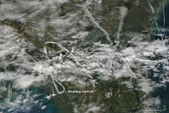
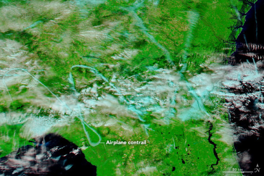
Curvy Contrails
On December 14, 2017, cloud scientist Bastiaan Van Diedenhoven spotted curious patterns in the sky over Florida and Georgia. The shapes—visible in natural color (top) and false-color (bottom) images from the Moderate Resolution Imaging Spectroradiometer (MODIS) on NASA’s Aqua satellite—were sketched by aircraft.
“These are definitely contrails,” said Van Diedenhoven, a researcher for Columbia University and NASA’s Goddard Institute for Space Studies. “Patterns like this don’t form naturally.”
Condensation trails, or contrails, are a type of cirrus cloud that forms in nearly the same way as naturally occurring cirrus. The difference lies in the source of ingredients. Aircraft exhaust contains an abundance of water vapor and small particles. At high altitudes, where it’s cold enough—at least -39°C (-38°F)—the water vapor can easily freeze onto the particles and form the long, narrow clouds.
The blue areas in the false-color image indicate ice, which is consistent with the icy composition of contrail cirrus. When the air temperature and humidity allow the ice crystals to stay solid, cirrus clouds can stick around for hours and move with the winds. In this case, the relatively long lifetime, unique shape, and isolation of the contrails made them easier than most to see from space.
“These are not uncommon, but can be hard to spot,” Van Diedenhoven said. “Often aircraft need to circle to wait for a chance to land at a nearby airport. I think these patterns are also hard to spot because of the busy air traffic and all the resulting overlapping contrails when the air conditions are conducive for creating contrails.”
Another clear example of curvy contrails occurred in March 2016, when half-circles were visible in the sky off the east coast of England. Van Diedenhoven identified the source to be a Royal Air Force aircraft, which he guesses might have been doing a research flight.
References and Further Reading
Worldview (2017, December 14) Aqua MODIS.
NASA Earth Observatory (2013, February 21) Criss-Crossing Contrails.
NASA Earth Observatory image by Joshua Stevens, using MODIS data from LANCE/EOSDIS Rapid Response. Story by Kathryn Hansen.
Instrument(s): Aqua - MODIS
10 notes
·
View notes
Photo
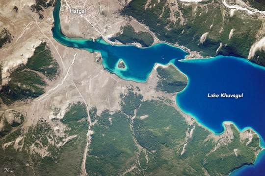
Lake Khuvsgul
An astronaut on the International Space Station captured this photograph of the southern tip of Lake Khuvsgul (also known as Lake Hovsgol or Hovsgol Nuur) in north central Mongolia. Referred to as the “younger sister” of Lake Baikal, Khuvsgul is approximately 137 kilometers (85 miles) long and is the largest fresh water lake in Mongolia by volume. (Note that north is to the lower right in this image.)
Several rivers and streams flow down from higher elevations (including the Sayan Mountains) and into Lake Khuvsgul. The Egiin River is the only outflow, ultimately carrying water to Lake Baikal through the Selenga River. Together, the two lakes hold more than 20 percent of Earth’s fresh surface water.
The different shades of blue indicate different water depths—the deeper the blue, the deeper the water. Boreal forests (also referred to as taiga) cover the mountain slopes, while several streams cut through the forest and flow into the lake. Hatgal, a village with less than 4,000 inhabitants, sits on the lake shore and makes up most of the population in Khuvsgul Province. The lake and its surroundings are part of 11,803 square kilometers (4,557 square miles) of protected land designated as Lake Hovsgol National Park.
Astronaut photograph ISS052-E-45462 was acquired on August 12, 2017, with a Nikon D4 digital camera using an 1150 millimeter lens, and is provided by the ISS Crew Earth Observations Facility and the Earth Science and Remote Sensing Unit, Johnson Space Center. The image was taken by a member of the Expedition 52 crew. The image has been cropped and enhanced to improve contrast, and lens artifacts have been removed. The International Space Station Program supports the laboratory as part of the ISS National Lab to help astronauts take pictures of Earth that will be of the greatest value to scientists and the public, and to make those images freely available on the Internet. Additional images taken by astronauts and cosmonauts can be viewed at the NASA/JSC Gateway to Astronaut Photography of Earth. Caption by Andi Hollier, Texas State University, Hx5, JETS Contract at NASA-JSC.
Instrument(s): ISS - Digital Camera
1 note
·
View note
Photo
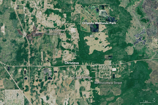
Where It’s Christmas Every Day
According to popular lore, Santa Claus lives at the North Pole. However, there are a few other locations that the trackers at North American Aerospace Defense Command may want to keep an eye on when they monitor Santa’s whereabouts on Christmas Eve this year.
One spot is a small town east of Orlando where it is Christmas every day. That town is Christmas, Florida, a place with a special mailbox in the post office for letters to Santa. It's a a place where streets have biblical names (Bethlehem, Matthew, and Bartholomew) or reindeer-themed names (Comet, Cupid, and Blitzen), and the post office gets a surge of traffic each December from people eager to have “Christmas” postmarked on their letters.
The town’s unusual name harkens back to a little known footnote in U.S. military history. During the Second Seminole War, soldiers began constructing a fort there on December 25, 1837. In the 1970s, a full-scale replica of the fort was built, and today Fort Christmas Historical Park is a popular tourist attraction.
The Operational Land Imager (OLI) on Landsat 8 captured this image of Christmas on April 7, 2017. Forested areas are dark green. Cleared areas, mainly pastures or farmland, are light green and brown. A fire appears to have charred vegetation west of Fort Christmas.
The town has a place in environmental history as well. Christmas is the site of what Orlando city officials call the first large-scale, manmade wastewater treatment wetlands in the world. Orlando Wetlands Park, once pasture land and now a 1,200 acre network of marshes, helps naturally cleanse tens of millions of gallons of wastewater each day.
By the time the water drains out of the park into St. Johns River, usually about 40 days after first arriving, native aquatic plants have filtered out many of the pollutants in the water. There were few other facilities like it when it was built in 1987, but today there are more than 2,000 similar wastewater facilities around the world (including 600 in the United States and 35 in Florida), according to Orlando Rising.
References and Further Reading
City of Orlando (2016) Orlando Wetlands Park. Accessed December 18, 2017.
Florida Today (2017, December 10) It’s Christmas every day in ZIP code 32709. Accessed December 18, 2017.
NASA (2011, December 18) NORAD and Satellite Technology Help Santa Deliver. Accessed December 18, 2017.
NASA Jet Propulsion Laboratory Photojournal Santa Claus, Ga./Ind. Accessed December 18, 2017.
North American Aerospace Defense Command NORAD Tracks Santa. Accessed December 18, 2017.
Orlando Rising (2017, October 7) Orlando Wetlands Park: A model for wastewater treatment. Accessed December 18, 2017.
The Verge (2016, December 24) The technologies NORAD is ‘using’ to track Santa Claus today. Accessed December 18, 2017.
Vice (2013, May 31) Welcome to Christmas Florida. Accessed December 18, 2017.
NASA Earth Observatory image by Jesse Allen, using Landsat data from the U.S. Geological Survey. Text by Adam Voiland.
Instrument(s): Landsat 8 - OLI
1 note
·
View note
Photo
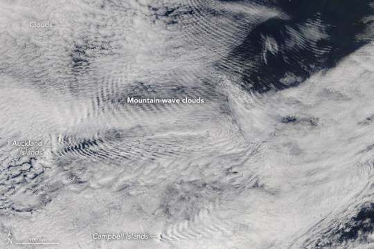
Waves in the Sky Behind the Auckland Islands
The next time you see a duck paddling over still water, look behind it. You should see a series of V-shaped waves rippling across the surface, with the two sides of the V forming a roughly 40-degree angle. The term physicists use to describe this distinctive pattern is a Kelvin wake, though other names such as bow waves are also widely used.
In the duck’s case, the motion across a stationary surface triggers the waves. A similar process can play out when air flows over a stationary object. That’s what was happening when the Moderate Resolution Imaging Spectroradiometer (MODIS) on NASA’s Terra satellite acquired this image of mountain-wave clouds near the Auckland Islands. The wave-driven clouds are flowing in an easterly direction on the lee side of the small archipelago about 450 kilometers (280 miles) south of New Zealand’s South Island.
The islands are known for their rugged terrain, and some of the peaks—including Mount Raynal, Mount D’Urville, and Mount Easton—surpass 600 meters (2,000 feet). With these summits poking well above the ocean surface, the islands disturbed the smooth, easterly flow of air and created atmospheric gravity waves and wave clouds that rippled through the atmosphere.
The presence of clouds makes it possible to see the waves. The cloudy-clear pattern marks the location of wave crests and troughs. The moist, cloudy air over the ocean (meteorologists call this the marine layer) is often capped by a layer of dry air. Clouds form (or persist) at the crests of the waves because air cools as it rises, and water vapor condenses into cloud droplets. In the wave troughs, dry air from above sinks into the marine layer, replacing the cloudy air. In addition, as air sinks, it warms and causes clouds to evaporate.
References and Further Reading
American Meteorological Society Lee Waves. Accessed December 1, 2017.
American Meteorological Society Mountain Wave. Accessed December 1, 2017.
Atmospheric Optics Atmospheric Gravity Waves. Accessed December 1, 2017.
Earth Science Picture of the Day (2009, March 31) Wave Cloud Animation. Accessed December 1, 2017.
Encyclopedia Britannica (2014, April 4) Bow Waves. Accessed December 1, 2017.
FYFD (2014, April 4) Ducks, boats, and other objects. Accessed December 1, 2017.
Hong Kong Observatory (2013, June) In the Wake of a Duck. Accessed December 1, 2017.
Physics World (2013, May 30) Physicists rethink celebrated Kelvin wake pattern for ships. Accessed December 1, 2017.
Slate (2014, May 11) Islands Awake! Accessed December 1, 2017.
NASA image by Jeff Schmaltz, LANCE/EOSDIS Rapid Response. Story by Adam Voiland.
Instrument(s): Terra - MODIS
0 notes
Photo
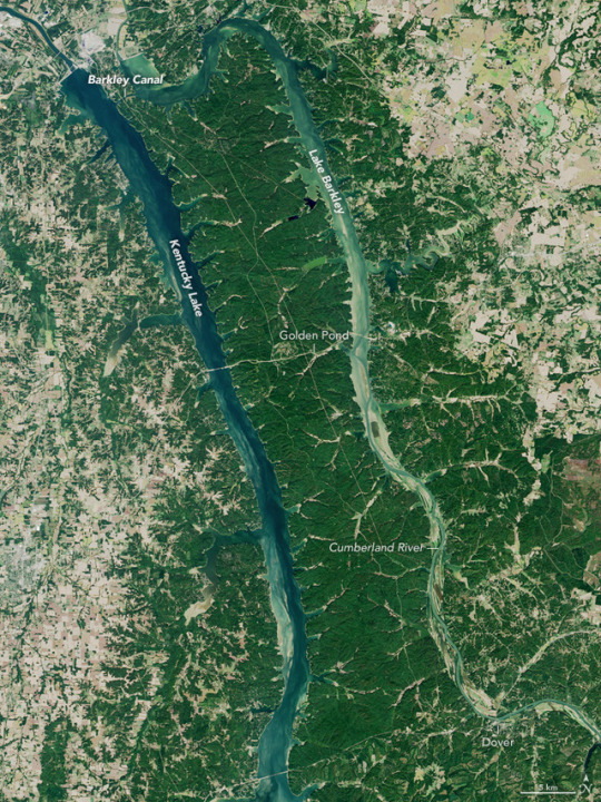
The Land Between the Lakes
For more than a hundred years, the fertile and forested patch between the Tennessee and Cumberland rivers was referred to as the “land between the rivers.” In the 1960s, it became the “land between the lakes.”
In an attempt to control flooding and to generate electricity in rural Kentucky and Tennessee, the Tennessee Valley Authority (TVA) built Kentucky Dam, thereby impounding the Tennessee River and creating Kentucky Lake in 1944. It became the largest manmade lake east of the Mississippi River.
Two decades later, the U.S. Army Corps of Engineers blocked the flow of the nearby Cumberland River as well. With the completion of Barkley Dam in 1966, the waters of the Cumberland piled up into Lake Barkley. In the process of creating the two lakes, residents of several small towns along and between the rivers were moved, and parts of some towns were permanently flooded. A few local roads and railways had to be re-routed.
Engineers also dug out Barkley Canal in order to bring the two rivers and lakes to the same water level. This allowed ships and barges to more easily move goods (without locks) from the Cumberland and Tennessee river valleys toward the mighty Mississippi River. By the time they were done, the TVA and Army Corps had created one of the largest inland peninsulas in the United States.
In the years after the lakes were created, the new peninsula was slowly converted into a recreation area for hunting, fishing, boating, hiking, and camping. Now managed by the U.S. Forest Service, the Land Between the Lakes National Recreation Area includes one of the largest freshwater recreation complexes in the United States. The parkland and lakes attract roughly two million visitors per year. The Operational Land Imager (OLI) on Landsat 8 acquired this natural-color image of the region on October 7, 2016.
Near Golden Pond, some forests have been cleared and re-seeded to return the land to what it likely looked in the 19th century. That grassland prairie also has been settled with elk and bison that once roamed the region. Recreational facilities also include a planetarium and a woodlands nature station. At the southern end of Land Between the Lakes, near the town of Dover, a re-creation of an 1850s homestead includes rare breeds of livestock and plants from that era.
References and Further Reading
NASA Earth Observatory (2017) National Parks from Space.
UNESCO (2017) MAB Biosphere Reserves Directory: Land Between the Lakes. Accessed December 14, 2017.
U.S. Forest Service (2017) Land Between the Lakes National Recreation Area. Accessed December 14, 2017.
Wikipedia (2017) Land Between the Lakes National Recreation Area. Accessed December 14, 2017.
NASA Earth Observatory image by Jesse Allen, using Landsat data from the U.S. Geological Survey. Story by Mike Carlowicz.
Instrument(s): Landsat 8 - OLI
1 note
·
View note
Photo
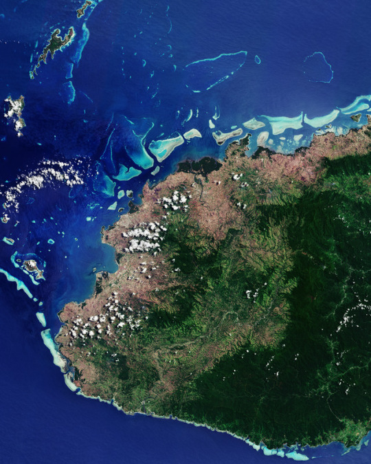
WESTERN AUSTRALIA
Released 03/11/2017 10:00 am
Copyright contains modified Copernicus Sentinel data (2017), processed by ESA, CC BY-SA 3.0 IGO
Description
Id 385920
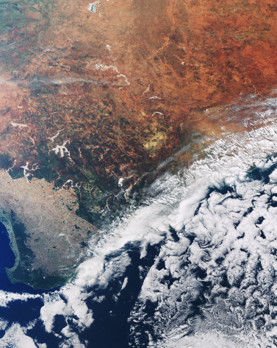
From the fourth most populous city to the rugged Outback, the Sentinel-3A satellite gives us a wide-ranging view over Australia’s southwestern corner.
This perspective from space clearly illustrates human’s influence on our environment: the agricultural landscape that dominates in the lower-left is suddenly interrupted by the more densely vegetated national parks and forests.
The city of Perth is located on the coast along the left edge of the image. About 150 km north of Perth sits ESA’s tracking station at New Norcia, where a 35 m-diameter radio dish communicates with deep-space missions such as Rosetta and Mars Express.
Moving further inland, grasslands give way to the deserts of Australia’s vast and remote interior – known as the Outback – with a landscape dominated by red soil and sparse vegetation. Several large salt lakes are visible across the image in white, including the appropriately named Lake Disappointment by explorer Frank Hann in search of fresh water (top of image).
Clouds over the ocean obstruct our view of the southern coast, but the lack of cloud cover over the interior desert pronounces the dry climate, which is a consequence of global wind patterns.
Sentinel-3 offers a ‘bigger picture’ for Europe’s Copernicus programme by systematically monitoring Earth’s oceans, land, ice and atmosphere to understand large-scale global dynamics.
While the satellite mission carries a suite of cutting-edge instruments, this image, also featured on the Earth from Space video programme, was captured on 9 April 2017 by the satellite’s Ocean and Land Colour Instrument, which helps to monitor ocean ecosystems, supports crop management and agriculture, and provides estimates of atmospheric aerosol and clouds.
24 notes
·
View notes
Photo
VITI LEVU, FIJI
Released 10/11/2017 10:00 am
Copyright contains modified Copernicus Sentinel data (2017), processed by ESA, CC BY-SA 3.0 IGO
Description
Id 386386
The Copernicus Sentinel-2B satellite takes us to the Republic of Fiji in the South Pacific Ocean on 28 September 2017. Part of Fiji’s largest island, Viti Levu, is pictured here, with coral reefs speckling the water.
Shaped by volcanic activity and earthquakes, the centre of the island is dominated by forests and a mountain range. The highest peak, Mount Tomanivi, reaches over 1320 m and is located on the central-right side of the image. While the area east of the mountain range receives heavy rainfall, the west side pictured here is in the ‘rain shadow’, meaning that the mountains block the rain clouds, leaving this area drier than the east.
In addition to the human population of some 600 000, one of the largest insect species also resides on Viti Levu: the giant Fijian long-horned beetle. The island is the only known home to the beetle, which grows up to about 15 cm long – excluding antennae and legs.
With more than 300 islands, the Fijian archipelago's low-lying coastal areas are at risk of sea-level rise – a devastating consequence of climate change. Satellites carry special instruments to measure sea-level rise – but not only. Different instruments can measure different climate variables, from greenhouse gases to melting glaciers, and offer a global view of the state of our planet.
The Republic of Fiji holds the presidency for this year’s COP 23 (Conference of the Parties) on climate, held this week and next at the UN Framework Convention on Climate Change headquarters in Bonn, Germany.
In February 2016, Cyclone Winston struck Fiji, damaging tens of thousands of homes and buildings, leaving more than 130 000 in need of shelter. With the COP 23 Presidency, Fiji calls for everyone to come together to build partnerships for climate action between governments, civil society and the private sector – and to work together to improve the climate resilience of vulnerable nations and communities.
This image is featured on the Earth from Space video programme.
19 notes
·
View notes
Photo
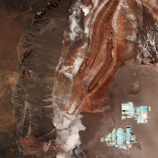
SALAR DE ATACAMA, CHILE
Released 17/11/2017 10:00 am
Copyright contains modified Copernicus Sentinel data (2017), processed by ESA, CC BY-SA 3.0 IGO
Description
Id 386674
From the Salar de Atacama salt flat in the east to the Cordillera Domeyko mountains in the west, Sentinel-2 takes us over part of the Atacama Desert in northern Chile.
The desert runs along part of South America’s central west coast. It is considered one of the driest places on Earth. Being a ‘coastal desert’, the cold, upwelling waters in the Pacific Ocean inhibit rain from reaching the land. Instead, the winds that blow from the ocean bring fog.
Because of the Atacama plateau’s high altitude, low cloud cover and lack of light pollution, it is one of the best places in the world to conduct astronomical observations and home to two major observatories.
Some areas of the desert have been compared to the planet Mars, and have been used as a location for filming scenes set on the red planet. ESA has even tested a self-steering rover in the Atacama, which was selected for its similarities to martian conditions.
In the lower right, the geometric shapes of large evaporation ponds dominate the Salar de Atacama – Chile’s largest salt flat. At about 3000 sq km, it is the world’s third largest salt flat as well as one of the largest active sources of lithium. From evaporation ponds like the ones pictured here, lithium bicarbonate is isolated from salt brine. Lithium is used in the manufacturing of batteries, and the increasing demand has significantly increased its value in recent years – especially for the production of electric-car batteries.
This image, also featured on the Earth from Space video programme, was captured by the Copernicus Sentinel-2A satellite on 29 April 2017.
19 notes
·
View notes