mcwater21
21 WI Waterways in '21
What could go wrong?
28 posts
Don't wanna be here? Send us removal request.
Last Seen Blogs

gravelvetart
GravelvetArt

sambiscits-blog
Sambuscus's
Things
And
Crap

avoidingtiger61
@AvoidingTiger61

youngneckpruneempath-blog
Untitled

duke5cinco
Untitled
Text
“DOUBLE HEADER” MC WATERWAY WEEKEND
May 16th – Milwaukee River – Saukville to Grafton
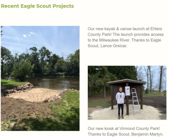
Back to the Milwaukee River. This time from Saukville to Grafton.
Thanks to Eagle Scouts Lance Greicar and Benjamin Martyn, we had a great launch point out of Ehlers Park.
It was a beautiful float down the river
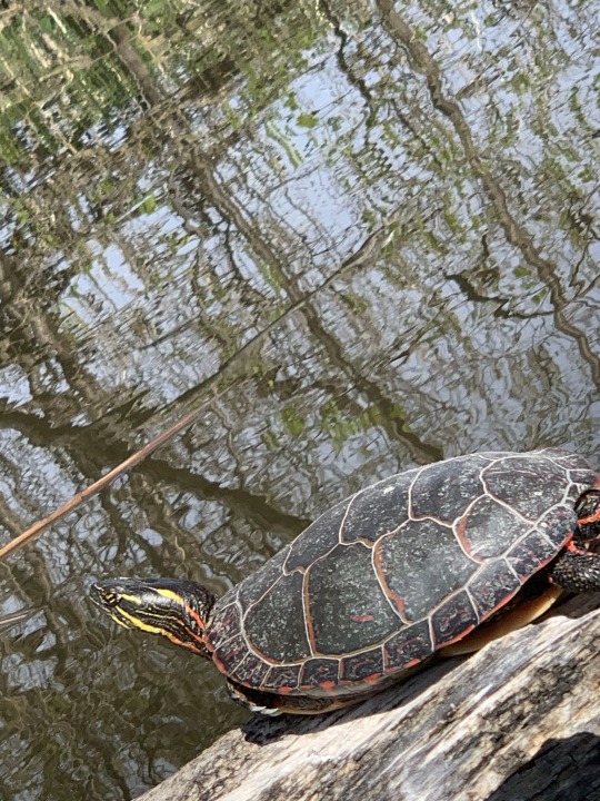
Matt did spend a good 15 minutes waiting for large, brown turtle to resurface to prove to Cindy that it did, in fact, exist. It never did, but we did see a number of smaller turtles.
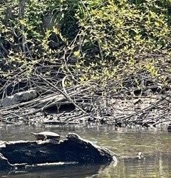
It was a beautiful float down the river with lots of wildlife Turtles, Ducks, Geese.


Beautiful homes. Great, peaceful, Sunday afternoon.
We are so fortunate
0 notes
Text
"Ride with Strangers “
Chain of Lakes, May 15th - Waterway #7

Where to? One might think there is some strategy behind our waterway selections, but it really doesn’t work that way. Its’ more like “Where should we go?” (the morning of). Matt was definitely doing his research and, after some collaboration, we headed to Waupaca and the Chain of Lakes.
The Plan? Two trips, same day. Lakes. Then move the car, drop a bike and venture down the Crystal River
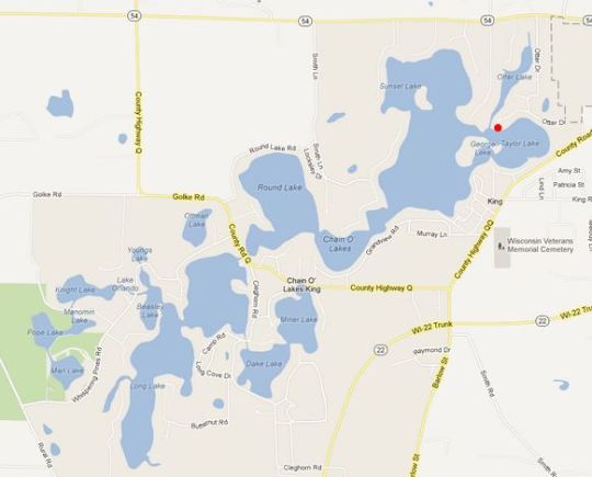
We started at Marl Lake. Marl Lake is a 14 acre lake with amazing turquoise crystal clear water. Fish were easily spotted in the beautiful water.
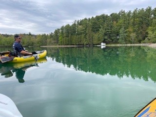
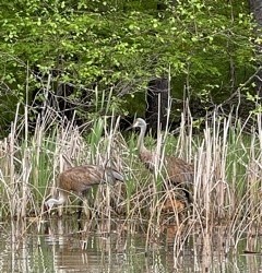
Immediately we heard and then saw Sandhill Cranes with two little chicks. Very quiet and peaceful.
Venturing through the channel we just forged forward. Through Pope, Knight, Beasley, Orlando and eventually amongst boats on Long Lake. Even though we hadn’t planned (nor placed a bike at takeout) we found ourselves on the Crystal River. Reminiscent of old times for Cindy for sure. Dings Dock and “canoing” the Crystal River with family and friends

Riffles, a few Class I rapids, some low spots, pretty cabins, no other people around. We took out near a highway where we thought we’d simply hail an Uber. Well – not here!
Eager for a walk, Cindy offered to hike it 3 miles back to the car. But then strangers intercepted her in a four wheeler and whisked her to the car. Riding with Strangers DID pay off!
Would love to come back here to explore all the other lakes, as well as nearby State Campgrounds, rivers and streams.
0 notes
Video
#7. Chain of Lakes, Waupaca, WI. Hit 7 of the 22 lakes and the Crystal River.
0 notes
Text
0 notes
Text
No need to fear THIS marsh!
Several people have asked what our elaborate master plan is for our 21 Wisconsin Waterways. Well let me tell you how this works. There is no plan! Usually we start chatting about upcoming weekend options mid-week via phone. Then we have a margarita on Friday night and hone in on maybe three – four possible options for Saturday/Sunday. Then alittle more research, study of weather, wind, other obligations, desire to travel, desire to take two cars and/or bike and, of course safety. And off we go.
Or – off we go and plan along this way! Anyway – this April weekend was no different. As I frequently do, I turned decision making over to Matt who selected the Husteford area – specifically Sinnissippi Lake.
Weather was cool, but we thought it would be O.K. However when we arrived at the lake, it was looking fairly choppy. Might have something to do with the depth of the lake. We also didn’t see any action on the lake. Could have ventured out, but really didn’t look like it would be an enjoyable experience.
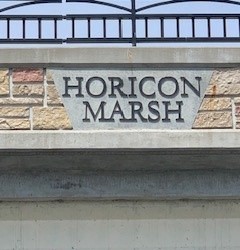
So to Horicon Marsh we went.
I have to say that I never had any intention of going kayaking on another marsh in my life (however long that may be). Especially after our near death trip 4 miles from my house. But Matt convinced me that this would be different. In that I had a fully charged phone, a back-up battery, a bag of safety equipment including water filtration tablets, I was in.
My only knowledge of the Horicon marsh was that I passed through it when I traveled to Madison over the years. (And there is a really bad speedtrap where I’ve been stopped, not once, but twice in this lifetime).
So basically I knew nothing.
A little bit about the Horicon Marsh. The massive Wisconsin glacier formed this area nearly 70,000 years ago! This is actually the same rock formation that created our wonderful state of Wisconsin, but is also the same rock layer that formed Niagra Falls.
The marsh itself is 14 miles long and ranges from 3-5 miles in width.
. At more than 33,000 acres, Horicon Marsh is one of the largest freshwater marshes in the United States and is a critical rest stop for thousands of migrating ducks and Canada geese. It is recognized as a Wetland of International Importance, as both Globally and State Important Bird Areas, and is also a unit of the Ice Age Scientific Reserve.
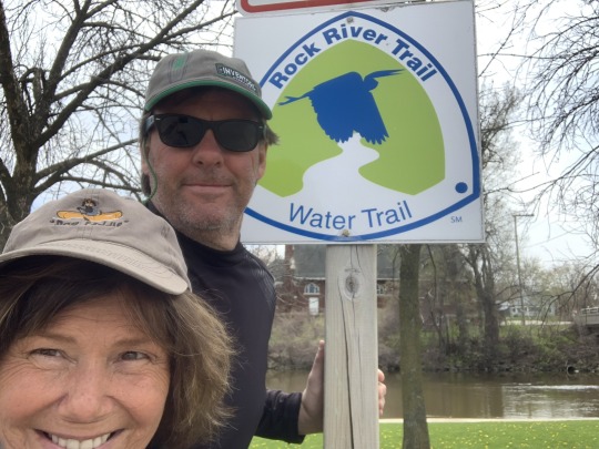
Horicon Marsh is fed by the Rock River which flows through the refuge, following a course through southern Wisconsin and eventually ending in the Mississippi River at Rock Island, Illinois.
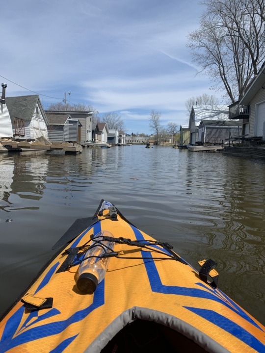
The big surprise for me of the day, was the “tiny homes” community that we paddled through. Wow – I think I could live here! Would require abit of downsizing. But perhaps this is Matt/my future – separate shacks on Horicon marsh, a sprinter van, place in Florida, place in Portland. We got this!


Oh – that’s right – I live here! Nevermind.

We did head out into the cattails. I only slightly hyperventilated as I envisioned cattails choking me. Then Matt demonstrated how these cattails were different that than Sheboygan Marsh – in that they moved! (see video) (Note – the benefit of a good dam thereby controlling water flow).

All in all - another great, great day on the water! Life is not just Good, but GREAT!
0 notes
Video
6. Horicon - Marsh 2.0
We ain’t afraid of no marsh - mo matter how big it is. And this one is the biggest. Check out the Horicon Wounded Warrior Duck Hunt video link at http://horiconmarshww.com/
0 notes
Text
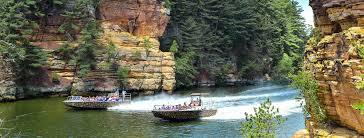
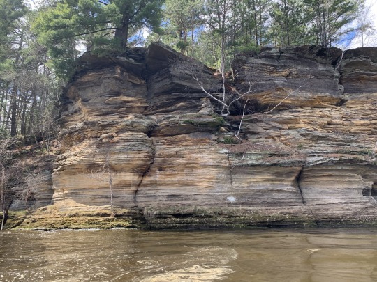
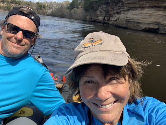
The Wisconsin River - Just “Ducky”
When we targeted Wisconsin Dells area for our next waterway(s), I thought back fondly on a trip I took many years ago with my best friend Joann and daughter Marla. We put in on the Wisconsin River north of the Dells. Kayaked. Slept overnight on an island, then continued down into the Dells where there was a big party going on! On my bucket list was to always kayak south of the dam to see the stunning gorges and rock formations that make up “The Dells”.
So what is unique about The Dells? The Dells area was formed during the last ice age – 15,000 years ago!! The area remained untouched by the gigantic, powerful Laurentide Ice Sheet (glacier) and became a part of the large driftless Area that was spared by the large sheets of ice. The melting of Laurentide formed Glacial lake Wisconsin (nearly the same size as Great Salt lake in Utah) and had depths of 150 feet. The lake was held back by a dam of ice created by the remains of the glacier. Eventually the ice dam burst and unleashed a catastrophic flood. The Lake’s depth dropped to only 50 feel, cutting deep, narrow gorges in its path. Thus the unusual rock formations

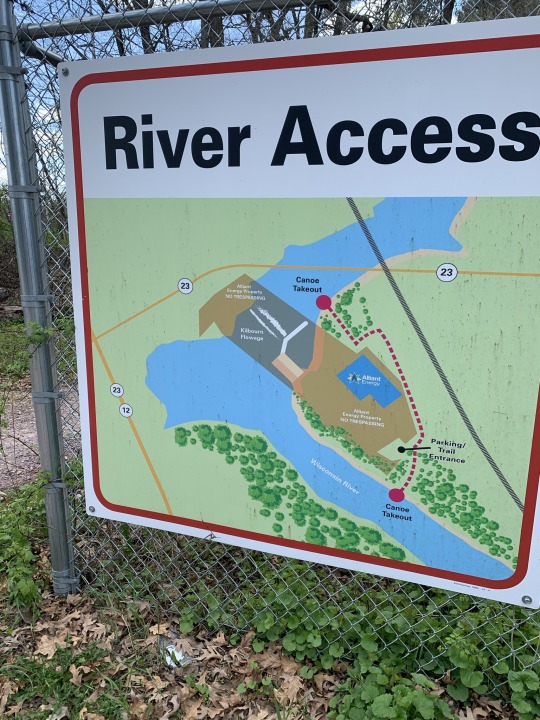
The lower dells are usually heavily trafficked by power boats in the summer and make kayaking a true “adventure”. So going in April was an experience unlike no other.
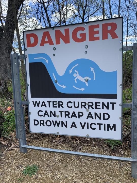
Matt suggested launching directly beneath the dam. I wasn’t a fan of this idea for a variety of reasons (I choose Life) and convinced him to seek a better spot.
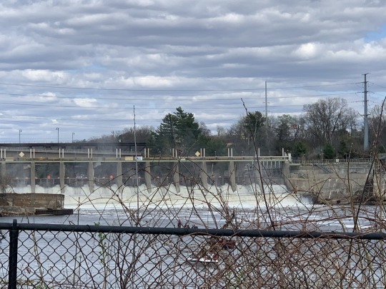
It took us abit to find an area that provided safer access, but well worth it (in that we are still alive).

The trip was beautiful. Weather was great. The scenery and rock formations - spectacular.


My favorite was racing a Wisconsin Duck! (See Matt’s video) and reflecting on our family Ducks trip back in the late 1990’s where my daughter Jamie got to drive. (or so she thought!)
I think we should do an entire Waterway year just on the Wisconsin River. And the Milwaukee River. And the Rock River. And, and, and. . . . .
I’m the luckiest girl in the world having found this guy! (80% of the time!!)
0 notes
Video
5. Lower Dells
Sunday, Sept. 17
Nice, easy, uncrowded paddle of the Lower Dells. 6 miles in 2+ hours. Cindy raced a Duck boat!
0 notes
Text
4. Mirror Lake Final Notes
Camping at Mirror Lake State Park
Off-season camping at Mirror Lake State Park was a bit dicey as you couldn’t reserve a site beforehand. There are 151 family campsites in three different campgrounds with seven group sites at the park that you can reserve from May through October. We were a bit lucky to find an open site within their limited off-season set of sites. Maybe it was the 30 degree nighttime temp that scared off many would-be campers. No worries for us - Cindy has her new winter sleeping bag and I have my ski gator. We love camping in any weather. There are more than 19 miles of hiking trails in the park and you might catch bass, walleye, panfish, and northern pike if you choose to go fishing here. And kayak/canoe rental at the boat launch. Check the park out at https://dnr.wisconsin.gov/topic/parks/mirrorlake
Kayak Test - Fail!
I do have a sweet fishing (aka angler) inflatable kayak but Cindy convinced me to try out her new backup kayak today, an enclosed Aquaglide Noyo 90 (short 9 footer @$400). We love our high quality Advanced Elements inflatables and Cindy loves her’s being enclosed while I love the openness of mine. She bought the Aquaglide to try out a new vendor and have a second kayak for friends to use. I tucked my long legs (I’m 6’1”) inside the Aquaglide and started out from the launch. Hmm, not very comfy here. Not use to being this cramped, from both length and width perspectives. The side tubes were probably a bit overinflated and they didn’t provide a lot of room for my big old buttice. My back was not going to enjoy this trip. So after 100 yards we headed back to shore and I switched back to my trusty open top angler model. Ahh, my boys can breathe again. Go for an enclosed model if you want to be protected from the elements and like a cozy fit. It may provide for an easier ride but I prefer to live on top. And to be fair to Aquaglide, a longer model may have worked out well for me. Unless it was enclosed. Before you invest in a kayak, try both enclosed and open models, and of varying sizes. Cindy has since returned her Aquaglide and ordered another Advanced Element kayak - and the same model she currently has.

I’ll be ordering another Advanced Element soon as well. Either a tandem or whitewater model. The https://www.advancedelements.com/ site provides a great set of options for all types of kayaking, from recreational to whitewater.
Sandhill Cranes
The hiilite of this trip was the Sandhill cranes and their nests. Quick SC notes: Incubation lasts for 29 to 32 days. Sandhill cranes raise one brood per year. In migratory populations, sandhill cranes usually lay their eggs in April and May. Incubation is by both sexes, 29-32 days. Female does more of incubating (typically all night, part of day). Young leave the nest within a day after hatching, follow parents in marsh. Sandhill Cranes usually nest in small, isolated wetlands—such as marshes, bogs, and swales—or within about 300 yards of the edges of larger ones. They prefer areas with vegetation growing in standing water, but some nest on dry ground.
A pair will return to the same nesting area each spring. When they arrive, the young from the previous year who have migrated north with their parents are driven off while the pair begins a new family. Sandhill crane males are slightly larger than females, weighing up to 14 pounds. Females remain closer to 10 pounds. The birds grow up to 5 feet in height measured from toe to the top of the head when they are standing on the ground. The male is generally a couple inches taller than the female.
Sandhill cranes are named for the Sand Hills region of Nebraska. Sandhill cranes are long-lived, up to 20+ years. Sandhill cranes have wingspans of approximately 6 feet. All cranes are omnivorous.

Kayak “strangers”
Cindy and I have learned that the best advice we get on kayaking is from the people on the ground, er in the water. At Mirror Lake we were so lucky to run into a lady kayaker on our way back from the marshy area. She directed us back into the marshy part to take a route in the backwoods that would get us to a major crane nest with “gigantic” turtle sightings on the way. That advice was gold. We met some of her friends along the way and they noted how this was a hidden gem route and don’t let the word out. Oops, too late. We ran into this group again back at the Ishnala beach and got some further advice on tomorrow’s Lower Dells route. It pays to talk to strangers. And the stranger the better. Unless it’s around the campsite and they look like Charles Manson. Seriously.
The Great Ishnala!
Ishnala wasn’t an official stop on my 19 Supper Clubs in 2019 adventure but I have to say how great this supper club is. One of the best in WI! Check out https://www.ishnala.com/. A great location on Mirror Lake, great building, great food, great bars, great outdoor waiting areas (including the beach), and a great place to end our kayaking at. Of course we were zombies by the time we returned and ate @8pm. Such a long day that started way back at 6am in Port Washington watching the sunrise. Too tired to even start a campfire before bed back at camp. Now that’s tired…
Google Earth Video + Space Mouse
For the video tour I posted earlier I used Google Earth and a new 3dconnexion space mouse that I just purchased for flying around earth. What a cool device! A little pricey at $150 but I am going to wear this puppy out with videos for each of our future trips. And maybe revisiting the deadly Sheboygan Marsh. The 3 minute video I produced for this Mirror Lake trip was a combination of Google Earth (GE) free flying with the space mouse and having GE auto-fly over the kayak route I manually marked. So free fly from home to Mirror Lake to give you a big picture perspective of where we went, auto-fly the specific kayak path, and finally free fly from the end of the kayak path back to the take-out/Ishnala. I then took those 3 videos from GE and imported them to iMovie where I added the audio track. I then posted the final iMovie video to our Tumblr blog. Will be interesting to see how much better (and shorter?) these trip videos get thru the year. I’m sure Cindy will be taking over on this front very soon.

And there’s a small chance we’ll have a drone flying over us one of these trips to get some crazy good video. Imagine controlling a drone while paddling down the river. Drone on auto-pilot, locked into our moving location. What could go wrong?
Satellite Images
Quick note on satellite images. Google Earth is nice because, unlike Google Maps, it will display the date when the displayed satellite image was taken. So for the Mirror Lake video I published, the satellite images were from 9/10/2017. Interesting to see how old these satellite images are and from what time of the year. Based on our Sheboygan Marsh trip, I looked into satellite images available outside of Google Earth/Maps and found a cool site called Earth Images at https://imagery.geocento.com/. You pick a location area, date range, and image quality and the site will return a list of satellite images (from different satellites) matching that criteria. It will show you if the images are free to download or if they cost $$. I found some free medium quality images of the Sheboygan Marsh that would have warned us of blocked paths that the older Google images didn’t show. But the free medium quality images of the Mirror Lake area didn’t reveal anything interesting. Not sure paying $100+ for higher quality images of Mirror Lake would have provided anything useful as well. May just reserve this special satellite image usage for “dangerous” marsh-like routes in the future. Or we just stay away from deadly marshes forever...
0 notes
Text
MC(indy)’s BLOG
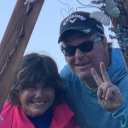
I have to say that I regularly give thanks that this journey in life has led me to this moment in time – adventuring 21 waterways with Matt who I love (80% of the time!) (That’s for you Mark and Tami)
Matt took control of the plan for Waterways #4 and #5 after I likely lost trust given the near death Sheboygan Marsh experience of #2. Not sure when I’ll gain trust to control the plan for future Waterways, but I’m really good with that.
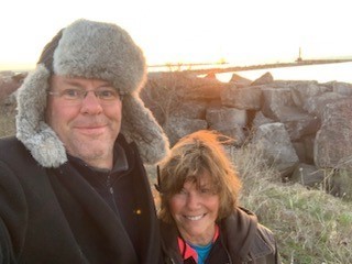
The weekend began with a wonderful Friday night with 2 of my 3 siblings in beautiful Port Washington. Cocktails and dinner with Randy & Jean and Lisa was so fun. Wish Mark and Amy could have been there. Next time.


Saturday morning was my first ever sunrise on Lake Michigan which kicked off the waterway weekend.

We then headed west. Road tripping we do really well. And 2 hours was too short! But we arrived at Mirror Lake Campground and found the perfect spot.

We did meet a couple who just purchased foldable kayaks. Interesting. Not sure they looked real comfortable but we were told you can actually backpack with them.


I attempted to launch my newly purchased “guest” kayak with Matt at the helm. Aquaglide Noyo 90. But he found it to be really uncomfortable. We switched and I did too. (On Monday it was returned) NOTE: If you are going to buy inflatable kayaks, we highly recommend Advanced Elements.

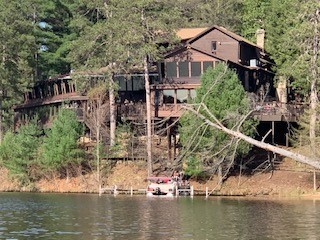
So Mirror Lake. Felt like a river or flowage. Very beautiful. Calm. Peaceful. Beautiful rock formations. Not a lot of people. And then the cranes. Amazing. We got so close to their nests.


We meet such cool people when we are out and about and today was no different. Along the path we met a women who gave us great insight into where to go. Only to meet her friends later at Ishnala.


Matt made some really interesting women friends at the Ishnala beach while I handled trekking for drinks, appetizers and reservations He spent a good amount of time with the these women and pranked me, upon my return, saying we were moving to their 12 bedroom Airbnb. (One of the women thought she recognized him from match.com. Hmm. So funny . . .NOT)
Anyway – Ishnala for dinner was wonderful even with a 2.5 hour wait. Only wish we hadn’t been too tired for a campfire. But we made up for that in the next morning with coffee brewed over a fire.
I love this guy. Glad I’m on this adventure with him.
0 notes
Video
4. Mirror Lake
Saturday, April 17th
First attempt at Google Earth-based video of one of our Kayak trips. Putting our sweet Mirror Lake trip into context prior to Cindy’s post.
0 notes
Text
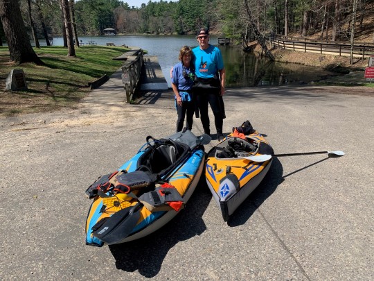
3. Newburg - MKE River
Sunday, April 11 (Stella’s 4th b-day!)
After last weekend’s near death at the Marsh, Cindy and I were looking for something a little safer and much more relaxing. We really enjoyed kayaking on the Milwaukee River just north of downtown MKE last year, so we went hunting for other sections of this river a bit closer to home. We found are a number of enjoyable routes from West Bend to Newburg to Fredonia to Grafton to Mequon to Glendale. After checking out https://www.wisconsinrivertrips.com/segments/milwaukee-river (great info on why dams are damn bad) we decided to run the relatively short 6 mile trek from Newburg downstream to County A. Estimated time 2-3 hours. Much, much shorter than our 8 hour Marsh trek!
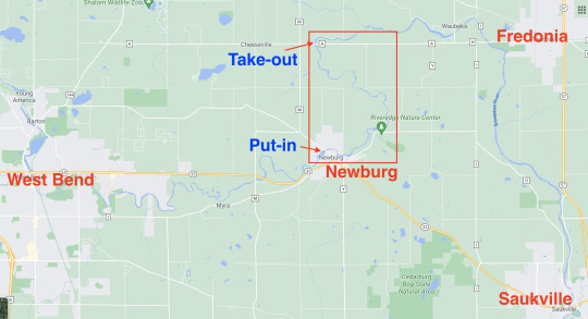
Little 6 mile segment of the Milwaukee River
Quick note about our blog purpose. Our hope is that readers will be inspired by our stories to check out these Wisconsin waterways, particularly for kayaking. We love our inflatables and we get a kick (but no commission) when we hear of friends purchasing their own inflatables and getting them wet. We hope that our info will help increase the safety and enjoyment factors on paddling some of the best waterways our beautiful state has to offer. Yay!
We dropped off my car off Highway A and drove Cindy’s car a few miles south to put-in at the little town of Newburg (check out No-No’s supper club). Cindy was sporting her new Henderson 7mm booties and a new emergency kit (see Marsh post). The air temp was low 50’s, water temp was 54, partly sunny, no threat of rain, and calm winds (5mph). I checked out Google Maps and recent free satellite pics and did not see any route blockage issues. So a nice relaxing paddle. And maybe time for a quick 9 afterwards. And then FaceTiming with my little grandie Stella on her big 4th b-day. Fun day Sunday!
At the Newburg put-in there were some class I rapids (aka ripplets) which put a little scare into us given our Marsh memory. But they were fun to start off with (class I is the easiest level) and a piece of cake even for beginners. We quickly sat back and enjoyed the quiet, low-risk route. The river was running 2-3 mph so we could often stop paddling and just look around - and relax. We floated by the Riversedge Nature Center (a must visit for hiking) and a few very interesting homes dotted along the way. Most notably a huge farm house/mansion with an Amish looking owner whose 2 kids were delighted to get chocolate eggs from Cindy. No stranger danger along the river today. Cindy is too cute.

Mansion on the river. Cindy to the right, egging on the kiddies.
Where’s the birds? Unfortunately there wasn’t much nature out to entertain us. One little otter. We were spoiled by the Marsh variety of birds and gnat clusters. I’ll have to do some research on the seasonal habits of the local birds and water creatures to help explain our loneliness today. Surprising the difference between these Sheboygan and Milwaukee rivers within a week span per the amount of birds we saw between the two.

Where are the birds?
When the water level is too low on this stretch, kayaks can often get stuck - yuck. This lengthens the trip and decreases the enjoyment level (per Sheboygan River run last year that took 5 hours and I missed my 100 year old neighbor’s b-day party). Before today’s trip I checked out the nearest Milwaukee River water level gauge (Cedarburg) at https://waterdata.usgs.gov/wi/nwis/uv/?site_no=04086600&PARAmeter_cd=00065,00060 and saw the river level was at 7.1 feet. That looked rather average for over the past year. I took river depth measurements (with my paddle) along the way and most of the river was only 2-3 feet deep. Again, a very low-risk route.

River speed is another factor that you sometimes have to worry about. The Cedarburg site also shows a Discharge rate in cubic feet per second (CFS). Just like the river height metric, I’m looking for how the current rate compares to the annual highs and lows and average. And the basic rule is that the higher the river, the faster the water is flowing. So today the river was at around 800 CFS which was a little above its annual average. So no worries about it being too fast for us. We ended up averaging 3mph so it took us just 2 hours to cover the 6 mile route. Easy peasy. Again, our Marsh “watermare” was 8 hours!

As the link review noted earlier, this is a very easy route and highly recommended for the beginner paddler. I’m sure we’ll be taking friends with kayaking-fears here in the next year or two. And this gets us stoked about “conquering” the other segments of the Milwaukee River, most notably the West Bend to Newburg and the County A to Grafton segments. And then the Grafton to Glendale segment. Oh, and then a repeat of the Glendale to downtown MKE segment which we tried last year where Cindy took a spill at the Estabrook beer garden. But that’s another story. And one best told by Cindy…
Oh, and stay tune for future posts to include Google Earth fly overs for our waterway routes. My 3Dconnexion 3DX-700059 Spacemouse Compact 3D Mouse arrives in a few days! Geek out baby.
0 notes