
Last Seen Blogs

omni-scient-pan-da
All Knowing Panda

narog1711
Escenas Gourmet

bihsnixr
im a joke

hantugunung
Kicap

julietta8631
This Will Be Boring
Photo

World map showing the United Kingdom and the locations of its 16 overseas military bases.
0 notes
Photo
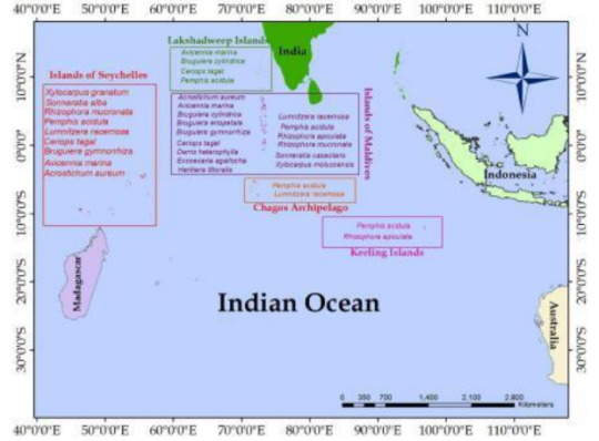
Vector map of the mangrove species diversity in the atolls of the Indian Ocean.
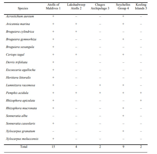
Mangrove species diversity of the atolls of the Maldives is impressive when those of the other atolls of the Indian Ocean are taken to consideration. The atolls of the Maldives support fifteen mangrove species. The Chagos Archipelago and the Keeling Islands support only two species. Aldabra atoll harbours a considerable number of mangroves (nine species), followed by the atolls of the Lakshadweep with four species.
0 notes
Text
The MFF Maldives Strategy and Action
Current Project 2017:
Red Production: Promoting locally effective solutions to waste management in G.Dh. Faresmathoda and G. Dh Vaadhoo in order to reduce environmental impacts
Maldives Authentic Crafts Cooperative Society (MACCS); Strengthening market links for sustainable Hau cultivation and conservation of the marshland in G. Dh. Fiyori
Hoededhoo Island Developemnt Society (HIDS): Establish a Proper Management of Waste Collection and Transportation in 2 Population Centers
Our Results:
2015
A Resilience Analysis was conducted in Huvadhoo Atoll to understand the prominent developmental and environmental challenges. Through the resilience analysis the MFF small grant programme was streamlined with the needs of the local communities with hopes of addressing the challenges they face
Two Small Grants were awarded during 2015.
The grant awarded to Red Production demonstrated several successes on waste management in the island of Faresmtahoda including establishing of a governance system and working towards systemic management of solid waste in the island. As such the waste management center was improved and operationalized with an island wide collection and treatment model.
The grant awarded to Maldives Authentic Crafts Cooperative Society worked on establishing market links with private sector for promotion of sale of Thundukunaa and Reed which is used for the mats. The appreciation towards the marshland was increased as a result which is immensely important for the resilience of the island.
2016
MFF Partnered up with Maldives Marine Research Centre to hold the first Marine Science Symposium in the Maldives.
Through the symposium knowledge and experiences were shared to contribute towards the conservation and sustainable utilization of our valuable marine environment and resources. A broad range of presentations were made that falls into marine science topics, including marine biodiversity, climate change, oceanography and conservation ecology as well as resource utilization and socio-economics.
The symposium brought together scientists from different areas of the field to share their knowledge and experiences from the various research projects that are being carried out in the Maldives.
A small grant project was awarded to Hoededhoo SIalnd Development society to work towards sustainable waste management in the islands of Hoededhoo and Nadella. As such working models from Maldives is planned to be implemented in the islands.
0 notes
Photo

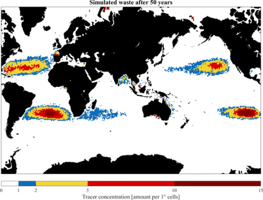
The Indian and Pacific Oceans are connected through the Indonesian Archipelago, which allows for warmer, less salty water to be transported from the Pacific to the Indian via a phenomenon called the Indonesian Throughflow.
Because of the Asian monsoon system, the southeast trade winds in the Southern Indian Ocean are stronger than the trade winds in the Pacific and Atlantic Oceans. These strong winds push floating plastic material further to the west in the Southern Indian Ocean than they do in the other oceans.
It is also likely that floating plastics will ultimately end up on beaches all around the Indian Ocean, transported by the reversing monsoon winds and currents. Which beaches will be most heavily affected is still unclear, and will probably depend on the monsoon season.
Our study shows that the atmospheric and oceanic attributes of the Indian Ocean are different to other ocean basins and that there may not be a concentrated garbage patch. Therefore the mystery of all the missing plastic is even greater in the Indian Ocean.
0 notes
Photo
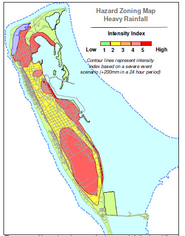
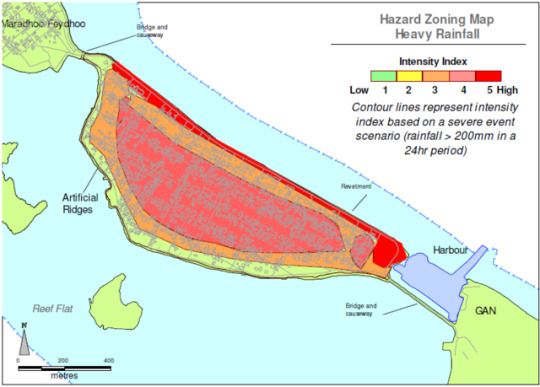
Hazard zoning map for heavy rainfall related flooding.
Heavy rainfall above the severe threshold is expected to flood low lying areas of the island especially near wetland areas, reclaimed wetland areas and reclaimed reef areas. The reclaimed wetland in the northern and southern have experienced the worst floods, while the reclaimed areas on the east are also very likely to be flooded in the future due to the runoff patterns and low elevation in the region. The area around the Addu Link Road is also reported to be particularly susceptible due the blockage of surface runoff towards the sea. At present the drainage system is reported to function
poorly due to high levels of sedimentation and lack of arrangement from the community and authorities to regularly clean them. The inner areas of the islands are likely to experience low levels of flooding due to remnants of taro pits and improper road maintenance activities. The rainfall hazard zones are approximate and based on the extrapolation of topographic data collected during field visits. A comprehensive topographic survey is required before these hazard zones could be accurately established.
0 notes
Photo

Hazard zoning map for tsunami flooding.
When a severe threshold of tsunami hazard (>3.0m on reef flat) is considered, the north eastern side of the island is predicted to receive the highest intensity. This is due to the low elevation of coastline and its possible direct exposure to tsunami wave trains. The small islands on the northeast are expected to absorb much of the wave energy but the southern half is expected to receive full energy. Wave height around the island will vary based on the original tsunami wave height, but the areas marked as low intensity is predicted to have proportionally lower heights compared to the coastline. Unlike Feydhoo Island which is protected from the direct path of tsunami waves, Hithadhoo is expected to receive higher intensity waves. Along with the eastern rim islands of Hulhudhoo, Meedhoo, Herethere and Viligilli are expected to experience the brunt of any large tsunami event.
0 notes
Photo

Hazard zoning map for swell waves and southwest monsoon high seas.
The intensity of SW monsoon udha is predicted to be highest 50m from the eastern coastline. It is unlikely that the western beach ridge will be overtopped
by udha events unless accompanied by swell waves. The eastern side however remain exposed during high tide and udha period due to low elevation. Intensity of swell waves is expected to be highest 50m from the western coastline and 150m from the eastern side. Swell waves higher than 4.0m on reef flat are predicted to overtop the oceanward ridge and penetrate 50-100m from coastline. There will also be a tendency for flood waters to flow rapidly eastward due to low topography especially if the duration of swell incident is longer or waves higher than 5.0m on reef flat. There is a small probability of swell waves propagating through the south western reef pass of the atoll if waves are oriented parallel to the pass. Such waves could affect the southern half of Hithadhoo up to 100m.
0 notes
Photo

Historical storm tracks (1945-2007) and possible direction of swell
waves for Addu atoll.
At present, it is very difficult to forecast the exact probability of swell hazard event and their intensities due to the unpredictability of swell events and lack of research into their impacts on Maldives. However, since the hazard exposure scenario is critical for this study a tentative exposure scenario has been developed based on the historical events.
In this regard there is a probability of major swell events occurring every 20 years in Hithadhoo with probable water heights less than 0.5 m on its western side and every 10 years with probable water heights of less than 0.5 m on its eastern coastline. Events with water heights less than 0.3 m are likely to occur more frequently on the eastern side due to high tides and low reclamation heights. A flooding probability of 20% was also observed for the eastern side, when the monthly peak tide reaches 2.3 m or more.
These tides usually occur in March, April, October or November. Tides alone may not have caused the flooding but its occurrence with swell waves would have triggered the events.
Land reclamation at lower heights may have exposed the eastern side more tidal flooding. This trend may continue with more planned reclamation activities, if the present reclamation practices are followed.
0 notes
Text
Coastal Modification
• Coastal infrastructure has been developed around Feydhoo Island. These
include a harbour on the northeastern side (including dredged areas,
breakwater and quay walls), causeways with bridges on both ends of the
island and coastal protection along the entire lagoonward shoreline to
protect the Addu Link Road. The road itself runs along the length of
lagoonward shoreline.
• Land reclamation has been carried out around the island to create
additional land for Addu Link Road development and to mitigate erosion.
The entire lagoonward shoreline has been reclaimed to approximately
50m form the original shoreline. The western shoreline was replenished
with sand following severe erosion in the north western and southwestern
areas.
• Much of the sand used for the reclamation and the construction of the
causeways were obtained from the lagoon between Gan and Feydhoo.
Approximately 4.8ha of lagoon area was dredged up to 3m deep.
• Due to these changes to the coastal environment, there appears to be no
alongshore transport on the lagoonward side of the island. There are
seasonal changes to beach line on the oceanward coastline.
0 notes
Photo
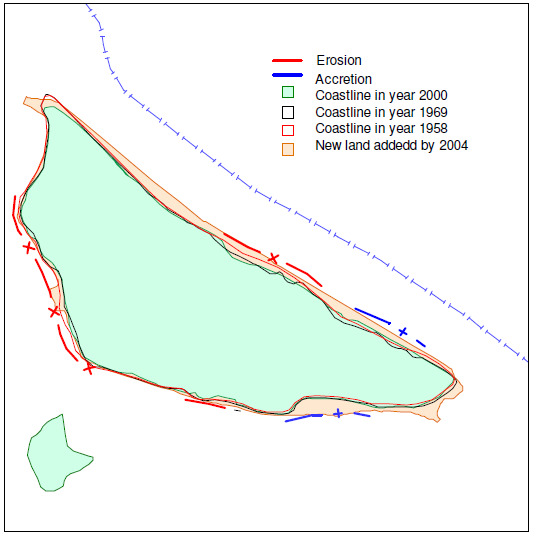
The islanders reported coastal erosion as a major problem on the island.
Analysis using historical aerial photographs shows that the island coastline has
been relatively stable compared to the island size (Figure 3.7). There have been
areas of erosion on both the eastern and western sides, some loosing up to 20
m. There have also been areas of accretion reaching up 20 m. The construction
of solid bridge preventing the flow of sediments around the island caused major
changes to the erosion and accretion patterns. On average Feydhoo has lost
about 300 m2 of land annually between 1958 and 1969, and lost about 500 m2 of
land annually between 1969 and 2000. The loss has been associated with gains
in other areas and the net erosion rate remained insignificant.
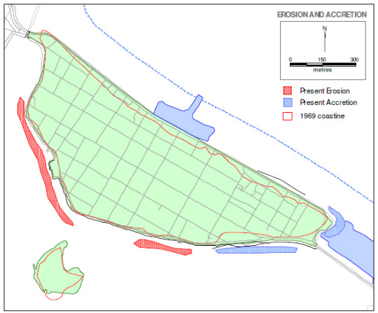
The modification of coastline, especially beach replenishment activities prevents
assessment of erosion against historical data. The present erosion and accretion
patterns are shown in Figure 3.8. At present the northwestern shoreline
undergoes periodic erosion, especially during SW monsoon. This process may
have been enhanced since the development of the bridge between Feydhoo and
Maradhoo-Feydhoo due to sudden increase in the current flow. The process is
most likely to stabilise in the long-run.
0 notes

Photo
Hazard zoning map for heavy rainfall related flooding in Feydhoo, Addu atoll.
0 notes
Photo


The British Indian Ocean Territory (BIOT) is an overseas territory of the United Kingdom situated in the Indian Ocean halfway between Tanzania and Indonesia, and directly south of the Maldives. The territory comprises the seven atolls of the Chagos Archipelago with over 1,000 individual islands – many very small – amounting to a total land area of 60 square kilometres (23 sq mi).[6] The largest and most southerly island is Diego Garcia, 27 km2 (10 sq mi), the site of a joint military facility of the United Kingdom and the United States.
The only inhabitants of the territory are US and British military personnel and associated contractors, who collectively number around 2,500 (2012 figures).[4] The removal of Chagossians from the Chagos Archipelagooccurred between 1968 and 1973. The Chagossians, then numbering about 2,000 people, were expelled by the British government to Mauritius and the Seychellesto allow the United States to build a joint UK/US military base there. Today, the exiled Chagossians are still trying to return, arguing that the forced expulsion and dispossession was illegal.[9][10] The islands are off-limits to Chagossians, casual tourists, and the media.
Since the 1980s the government of Mauritius has sought to regain control over the Chagos Archipelago, which was separated from the British Colony of Mauritius by the UK in 1965 to form the British Indian Ocean Territory. On 23 June 2017, the United Nations General Assembly (UNGA) voted in favour of referring the territorial dispute between Mauritius and the UK to the International Court of Justice (ICJ) in order to clarify the legal status of the Chagos Islands archipelago in the Indian Ocean. The motion was approved by a majority vote with 94 voting for and 15 against.[11][12]. Judge Abdulqawi Ahmed Yusuf described the UK's administration of the Chagos Islands as "an unlawful act of continuing character". In February 2019, the International Court of Justice in The Hague ruled that Britain should transfer the islands to Mauritius as they were not legally separated from the latter in 1965. The ruling is not legally binding.[13]
0 notes
Photo

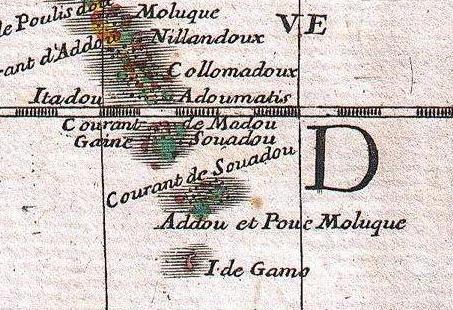

This channel lies between Haddhunmathi Atoll and Huvadhu Atoll and it is one of the broadest channels between the atolls of Maldives.
In the British Admiralty charts it is called One and a Half Degree Channel. On old French maps it appeared as Courant de Souadou.
Roughly in the middle of the broad Huvadu channel there is a small bank known as Medutila (also called Derahaa). This place is the peak of a submarine mountain, and perhaps an atoll in the process of formation. This submerged bank is very difficult to spot for at its shallowest point there is a depth of 6 fathoms (11 m). It looks like a paler blue patch surrounded by huge expanses of the deepest ocean. There, no island can be seen in the horizon for many dozens of miles.
0 notes
Text
Suvadive State
https://www.academia.edu/5045274/Symbols_of_the_Suvadive_State
http://www.maldivesroyalfamily.com/maldives_suvadive_oshea.shtml
http://www.maldivesroyalfamily.com/maldives_suvadive.shtml
0 notes