#rani sui lake trek difficulty
Text
Exploring the Rani Sui Lake Trek Difficulty: What to Expect
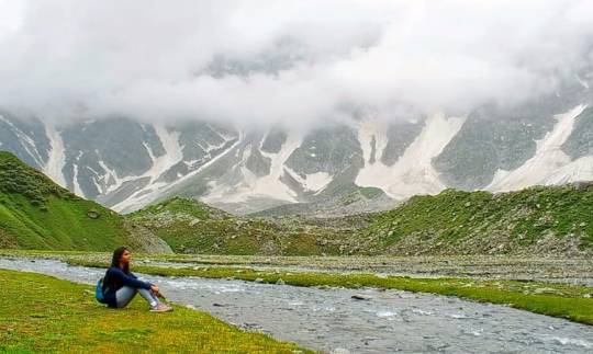
If you're an adventure lover and looking for a trekking experience in Himachal Pradesh, then the Rani Sui Lake trek is a must-visit for you. Nestled in the heart of the Dhauladhar Range, the trek offers mesmerizing views of the surrounding valleys and mountains, making it a popular destination among trekkers.
But before you start packing your bags, you may be wondering about the Rani Sui Lake trek difficulty level. Is it suitable for beginners, or is it more challenging? Here's what you need to know:
Trek Difficulty Level
The Rani Sui Lake trek is considered a moderate level trek, suitable for both beginners and experienced trekkers. The trek covers a distance of around 16 kilometers, which can be completed in two days, and involves an ascent of approximately 1,800 meters. While the trek is not too steep, there are some stretches that can be challenging, especially for those who are not used to trekking at high altitudes.
Altitude Sickness
One of the main challenges of the Rani Sui Lake trek is the high altitude. The trek starts at a height of around 2,200 meters, and the Rani Sui Lake is situated at an altitude of 3,750 meters. This can cause altitude sickness, which can be dangerous if not treated properly. It is essential to take proper precautions and acclimatize yourself to the high altitude before embarking on the trek.
Weather Conditions
The weather conditions on the Rani Sui Lake trek can also pose a challenge. The trek is open from May to November, but the monsoon season from July to September can make the trekking trail slippery and difficult to navigate. In addition, the temperatures can drop significantly at night, so it is essential to carry warm clothing and gear.
Terrain
The Rani Sui Lake trek involves trekking on a variety of terrains, including rocky paths, dense forests, and steep slopes. Some stretches of the trek may require scrambling over boulders or walking on narrow paths, which can be challenging for some trekkers. It is essential to wear sturdy trekking shoes and carry trekking poles for added stability.
Fitness Level
While the Rani Sui Lake trek is suitable for both beginners and experienced trekkers, it is essential to have a good level of physical fitness to complete the trek comfortably. The trek involves walking for several hours each day and climbing steep slopes, so it is recommended to start preparing for the trek at least a month in advance. You can start by doing some basic exercises such as jogging, cycling, and hiking to build your stamina and endurance.
Acclimatization
Acclimatization is crucial when it comes to high altitude trekking, and the Rani Sui Lake trek is no exception. It is recommended to spend at least two days in McLeod Ganj or Dharamshala before starting the trek to acclimatize yourself to the high altitude. During this time, you can explore the town, do some short hikes, and rest to allow your body to adjust to the altitude.
Packing Essentials
When it comes to trekking, packing the right gear and equipment is essential for your safety and comfort. For the Rani Sui Lake trek, you will need warm clothing, a good quality sleeping bag, a waterproof jacket, trekking shoes, gloves, and a hat. You will also need a backpack to carry your essentials, such as water, snacks, sunscreen, and a first aid kit.
Guided Tours
If you're not an experienced trekker, or if you prefer to have a guide to show you around, there are several trekking companies that offer guided tours of the Rani Sui Lake trek. These tours typically include a guide, transportation, accommodations, and meals, making it a hassle-free way to explore the trekking trail. However, be prepared to pay a higher price for the convenience of having a guide.
Conclusion
The Rani Sui Lake trek is a beautiful trekking trail that offers stunning views of the Himalayas and the surrounding valleys. While the trek does have its challenges, including altitude sickness, weather conditions, and terrain, it is a moderate level trek that can be completed by both beginners and experienced trekkers who are in good physical condition. With proper preparation and precautions, you can enjoy a memorable trekking experience in Himachal Pradesh.
0 notes
Text
Rani Sui Lake Trek: A Breathtaking Trek in the Lap of Himalayas
An undiscovered gem in India's Uttarakhand state's Kumaon region is the Rani Sui Lake Tour. The few who want to enjoy the excitement of trekking while taking in beautiful vistas of snow-capped peaks, lush green forests, and crystal clear glacial lakes have to choose this fairly difficult trek. The Rani Sui Lake Trek and all it has to offer will be explored in detail in this blog.
Starting Point: Loharkhet
The trek started in the rural village of Loharkhet, about 8 hours' driving from the nearest train station, Kathgodam. A long ascent over dense oaks, rhododendron, and deodar plant forests announces the beginning of the walk. The sound of rushing streams and rivers can be experienced as you walk along the trail, adding to the incredible natural beauty.
Rani Sui Lake
You may expect to trek for about 6-7 hours to get to Rani Sui Lake, which is located at an altitude of 11,480 feet. The lake is surrounded by winter weather mountains, making it the ideal location for photography. You'll never forget the wonderful moment created by the reflection of the surrounding mountains in the lake's crystal clear water.
Camping at Rani Sui Lake
In Rani Sui Lake, camping is a new experience. You can really see thousands of stars sparkling brightly above you in the clear night sky. The only sounds that interrupt the night's silence are now the wind swirling and an owl's frequent hooting.
Trek to Pindari Glacier
The third day will see the beginning of your walk to Pindari Glacier, which is around 7 kilometers away from Rani Sui Lake. There is a gradual elevation to the destination during the journey, and the scenery of the mountains and glaciers in the area is spectacular. The massive wall of glacier you'll see as you reach the glacier is amazing.
The Final Descent
You can start your last descent to Loharkhet on the fourth day. You have to take caution while walking because the descent is steep. It will be enjoyable to descend because the trail offers a beautiful view of the surrounding mountains and valleys.
Conclusion
A hidden gem, the Rani Sui Lake Trek offers breath-taking Himalayan views. The few who want to experience the thrill of trekking while enjoying the area's natural beauty definitely take on the trip. The trip should be done for environment enthusiasts since it offers a breathtaking view of winter weather mountains, glacial lakes, and green forests.
0 notes
Text
rani sui lake trek difficulty
Take the road less traveled and journey to Rani Sui Lake for a trekking adventure like no other! This destination will challenge you and reward you with breathtaking views. Get ready to conquer the rani sui lake trek difficulty and make memories that will last a lifetime.
0 notes
Text
Rani Sui Lake Trek is an unforgettable adventure
The Rani Sui Lake Trek is an unforgettable adventure that takes you through the stunning landscapes of the Himachal Pradesh region in India. In the Kullu Valley, this moderate trek starts from Jari village and passes through dense forests, meadows, and small streams, with spectacular views of the surrounding mountains. Its highlight is the Rani Sui Lake, which is situated at an elevation of 11,500 feet and is surrounded by snow-capped peaks. For adventure enthusiasts and nature lovers alike, this trek offers not only the opportunity to see the natural beauty of the region but also the local culture.
0 notes
Text

Ladakh is one of the highest regions of the world. Its natural features consist mainly of high plains and deep valleys. Ladakh is most famous for its breathtaking landscapes, crystal clear skies, the highest mountain passes, thrilling adventure activities, Buddhist Monasteries, and festivals.
BOOK YOUR TRIP WITH US
www.mountainstory.in
#Leh Ladakh Bike Trip#leh ladakh quotestion#ladakh bike trip budget#rani sui lake trek#rani sui trek#rani sui lake trek difficulty
0 notes
Text
One of India's most stunning hill states, Himachal Pradesh is no less than a paradise. Dotted with verdant meadows, revered shrines,
snow-covered mountains, gushing rivers, beautiful orchards, architectural marvels, and colourful monasteries book your trip with us end get best services
#Leh Ladakh Bike#leh ladakh quotes#ladakh bike trip budget#rani sui lake trek#rani sui trek#rani sui lake trek difficulty
0 notes
Text
Rani Sui Lake Trek: A Scenic Journey That Tests Your Limits
Take your trekking experience to new heights with a journey to the Rani Sui Lake! This picturesque destination will test your limits and reward you with breathtaking views and memories that will last a lifetime. Whether you're an experienced trekker or just looking for a new challenge, the Rani Sui Lake Trek is a must-do. Get ready to conquer the difficulty and come back with a sense of accomplishment. Book your trip today!
0 notes
Text
Conquer the Rani Sui Lake Trek: A Challenging Adventure Awaits
Embark on a challenging yet rewarding trek to the beautiful Rani Sui Lake! This off-the-beaten-path destination offers breathtaking views and a chance to test your endurance. Don't let the difficulty of the trek deter you, the experience and memories you'll gain are worth it. Get ready for an adventure of a lifetime and conquer the Rani Sui Lake Trek.
0 notes
Text
Rani Sui Lake Trek | Sour Tal Trek – Fun and Adventure
It is my intention to keep this post as focused on the Rani Sui Lake trek as possible. First of all, I should introduce myself as a professional in the IT industry with a well-known (for the wrong reasons) work-life balance. In my opinion, the best way to describe me is that people who are going through a midlife crisis will be able to relate to me most. I do enjoy traveling, but at leisure and comfortably.
Rani Sui Lake Trek / Sour Tal Trek
Known as Sour Tal, Rani Sui Lake (3700 meters ASL) is not so well known among trekking circuits. There are far more popular destinations with Manali (a popular hill station) being a good starting point.
After this trek happened in 2017, I wrote about it on my WordPress site. On May 27 this year, exactly three years later, we relived some of the summit moments on our WhatsApp group. As a result, I decided to share my experience with this community, as well as some information about this trek. I think it's better late than never to recount my experience with this community.
The Plan
As you might have noticed in my introduction, I am not an avid trekker. Far from it. I got into this because of my persuasive friend Sudhakar. This is how a typical conversation would go with him after the general chit-chat.
Friend: By the way, we are going for a trek to rani sui lake
Me: Oh cool, so where is this place?
Friend: Describes the place, the plan, duration, etc.
Me: Sounds like a good experience, but not sure if I can join
Friend: Ok think about it and let me know if you would like to join.
Once the call ends, I never express an intention to join the trek. This has occurred so many times that slowly he stopped insisting that I join.
It was sometime in July 2016 that we spoke again. The conversation went similar to the one above, but this time he was more determined. He was also the designated trek leader for Karnataka Mountaineering Association (KMA). In his opinion, another friend of ours, Sri, was also considering participating.
Jai, my cousin, was also suggested by him. His ultimate lure – four friends together on a trek, having fun. I was getting into an unavoidable situation. I talked to my cousin, hoping to get out if he wasn't interested. Instead, he got on board. Eventually, I also accepted the idea of a trek, and we signed up on it by the due date.
The program dates were 21-05-2017 to 31-05-2017, and all meals, accommodation, and travel were included.
Trek days: 24-05-2017 to 29-05-2017.
Manali
On either side of Manali, there are mighty mountains. On the left side, the Pir Panjal ranges rise to dizzying heights of peaks like Deo Tibba, Indrasan, etc. On the right side, the Dhauladhar ranges rise to equivalent heights.
Located above the snowline, Sour Tal is located in the middle of this range. We were many first-timers who enrolled in the program as it is classified as an easy-moderate trek. As a result, we had a lot of questions about it and trekking in general. Through emails and a WhatsApp group, KMA kept us informed.
As part of the briefing, rucksacks were distributed and we were instructed to walk/run 6 km a day within an hour every day as preparation.
It was also during this time that we became acquainted with the other batch 3 members, as we did half-day treks to Kabbaladurga on 26-03-17 and Savandurga on 16-04-17 near Bangalore.
My focus will be on the trekking expedition, not the details of reaching Delhi.
Prini Base Camp (1950 meters)
The Volvo bus took us to Manali in the morning, where we were greeted by the snowcapped peaks through the panoramic windows. From there, we were transported to Prini base camp in jeeps.
This property is located around 5 km from Manali town, on the road between Naggar and Kullu. Prini Nallah, a stream that flows next to the property, is a popular base for trekking expeditions.
Upon arrival, we were introduced to the local guides - Sonu, Om, and Samir. Our tents were assigned, and breakfast was about to be served in the dining tent. As we ate breakfast in the dining tent, we were introduced to the rigid schedule:
5:30 AM – Wake up call
6:00 AM – Tea/Coffee
6:15 AM – PT (Physical Training)
7:00 AM – Breakfast (followed by (re)packing rucksack and backpack)
8:00 AM – Trek starts
1:00 PM – Trek ends, Lunch
4:00 PM – Tea/Coffee
6:00 PM – Soup
7:00 PM – Dinner (no artificial lights after sundown)
An overview of the campsite and expedition was provided. All campsites had already been established and the trail had been mapped out. After the briefing on trek days, energy packs (juice, chocolate, biscuits, etc) would be distributed. Our backpacks would be carried to the next campsite by mules, while our rucksacks would be carried on mules. Very convenient!
Getting Ready
It was also equipped with electricity, a fixed toilet structure, and bath facilities. There was a peculiarity, however, in that the men’s bath and toilets were on the other side of the stream. To reach the restrooms, we had to descend down to the stream, cross a narrow rickety wooden bridge, and climb up to the same height. The stream was a frequent hurdle for us, while the women participants were thrilled to see it.
Prini Nallah wooden bridge
It started raining during our acclimatization walk. After the rains, the sky cleared and we could feel the freshness in the air. A few of us went for a walk and spent some time here enjoying the views and just chatting.
As we were introduced to Ganga Ram, the main guide for the trek, I felt amused as I zipped myself into my tent for the very first time.
Acclimatization Walk
After breakfast, we took the acclimatization walk through apple orchards and mountain villages.
In Shuru village, we stopped at a serene temple mid-way. A further hour's walk brought us to Arjun Gufa, which was around 4 hours from base camp.
Afterwards, we went for a walk into a nearby village before returning to camp for “soup time”. We then settled in our tents and drifted off to sleep only to be awoken by outside noises.
Our group had several members who were sick and we could hear them vomiting. Even without getting out of the tent, we could recognize them. Slowly, we gave in to sleep again, hoping for tomorrow to be better.
Camp 1 – Klount (2230 meters)
Not because I was sick, but because ten-12 of the 35 members had fallen ill just as the trek was about to begin. The mood was more anxious than upbeat as everyone gathered for the briefing for the day.
We instead got a scolding from Mr. Khemraj Thakur - the proprietor of the Base Camp. A man in his 60s with mountaineering experience, he blamed stomach infections on inadequate warm clothing.
In the byllanes we walked towards the Beas valley. Then there was a steep descent towards the Bhanu bridge, where we bought some packaged drinking water so we wouldn't have to drink water from the base camp.
On the Dhauladhar side, we crossed the bridge and started climbing over a concrete path paved for villages. The paved path soon ended and we entered a pine forest. The slope was quite steep, but because of the shade, it was very cool and pleasant. Eventually, mules with our rucksacks caught up with us.
Midway, we stopped and rested – trying out all filmy photoshoots. A hike of another hour and a half brought us to the campsite. The campsite was located in a small clearing among trees. Welcome drink (of non-alcoholic nature) was being served. The cool breeze, beautiful views, and the refreshing drink took all our tiredness away.
At the Campsite
A "rope walking" activity was planned for 3:00 PM after lunch. Safety equipment was explained. Most people tried it out and enjoyed it. I acted as a spectator and encouraged them.
During tea, Mr. Sridhar had reached. We gave him a jeep ride to the village, and he also managed to climb through the pine forest.
As there was no electricity here onward, we had to take advantage of the late sunset and finish dinner around 7:30 PM. We had rasam (like a spicy and tangy soup) on the menu thanks to Mr. Raghavendra. It was just the right dish for the cool weather. We got into our tents shortly after dinner and awaited sleep.
Camp 2 – Dudu Dhog (2750 meters)
After a good night's sleep, I felt comfortable zipping into a sleeping bag and tent. Dawn was already breaking by 4:45 a.m., and the sky began to light up. It was a beautiful morning. I sat around and took in the fresh air for some time. Afterward, morning tea was served, and we prepared our rucksacks and day packs. After breakfast and the briefing, we set out for the next campsite.
After passing through cedar/pine forests until the mid-way point, the trail continued through cedar/pine forests. As we hiked higher, the density of trees diminished. The trail mostly took us through fresh, green meadows in the open sun. People who arrived earlier rested under trees while I stayed out in the sun, enjoying the breeze and warmth. We reached the mid-way point after a steady climb of a couple of hours.
Ganga Ram encouraged us to start climbing again after 30 minutes of chit-chatting. The hot water at Klount campsite was not palatable, and I was running out of water. I kept walking ahead to find some water as I zigzagged up the steep incline in a zigzag pattern. The group slowly approached a small clearing shaded by trees where there was a small stream of water.
This water was very fresh and tasty. While it quenched my thirst on one hand, it also made the ground slippery as we climbed higher. The campsite was visible at this point.
The Campsite
Upon arriving at the campsite, I received multiple servings of welcome beverages. Tents were assigned, and lunch was served shortly after. The adventure activity was rappelling. Some of us remained at the campsite to relax and refresh.
Our group gathered around the dining tent as the sunlight dimmed. After being mesmerized by Divya (Raghavan), the campsite staff prepared a campfire outside. The last rays of the Sun were fading away as everyone assembled around the fire with their dinner. Soon it was dark.
As we washed dishes with torches, our fingers were going numb. What's a campfire without songs and dance? Boring! Several people joined the party, especially the youngsters. Slowly, people began retiring to their tents.
Camp 3 – Laanga Thach (3320 meters)
We had escaped physical training at Klount campsite but not at Dudu Dhog camp. I awoke early to catch the sunrise after an uneventful night's sleep.
As if trekking wasn't enough, we had to line up after tea in a small clearing between trees with level ground. Fitting 37 people within the available space was challenging, especially for PT exercises.
After PT we packed our bags quickly and assembled for breakfast and the day’s briefing. Ganga Ram explained the terrain leading to the next camp and concluded, as always, that “We should be there in 3-4 hours”. To reach Laanga Thach, we must climb over 3000 m (another first for me).
In the morning, the trail was out in open pastures and meadows as the treeline thinned out. The climb was constant, with varying degrees of incline. We stopped for a mid-way break after about 2 hours of climbing. I felt a little lightheaded after crossing the 3000 m mark, but it was manageable.
As we continued, we could see patches of snow nearby the campsite, which was set just above treeline. It took us just over an hour to reach it.
The Hailstorm
Indrasan and Deo Tibba were formidable peaks in the Pir Panjal range. Despite the cold, I felt a sense of accomplishment already.
It was as if the icing on the cake that we were given a “deluxe” 4 men tent. As the views around me were so captivating, I didn’t realize when my dizziness faded away, and I felt just fine. Everyone was outside the tents, unlike yesterday. Perhaps they felt the same way as I did.
It started drizzling after lunch, and we scampered into our tents as it transformed into a hailstorm. We watched as pea-sized ice balls fell from the sky, some of which bounced into our tents.
After tea time, the campsite staff provided hot tea inside each tent, a very kind gesture. The skies cleared in some time, but adventure activities for the day were canceled. The atmosphere became magical as clouds began to drift through the valley.
As sunlight weakened, the temperature plummeted to 4 °C. Down jackets were readily available for those in need. I had sufficient warm clothing, so I didn't need them. At dinner, we were treated with hot rasam rice - courtesy of our trek leaders. As we retired to our tents for the night, we were looking forward to summiting the mountain tomorrow.
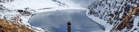
Summit – Rani Sui Lake / Sour Tal (3700 meters)
If you have read the posts until now, you will know that I used to have sound sleep in the night – while others complained of fitful sleep. In Laanga Thach, a little while after dozing off to sleep, I felt suffocated and woke up. As a result, Sudhakar and Jai were already awake, and they felt the same way I did.
As the wind blew outside, the tent flapped. Although the sleeping bag was lined with fleece, it was very cold, so we opened the vent window flaps despite the fact that it would make the room even colder. After a while, I fell asleep blissfully. It was only ventilation that was bothering me, not altitude or anxiety.
Our plan was to reach the summit by (late) lunchtime and descend to Camp 4 by (late) lunchtime, as we had already been informed the previous day. As a result of clubbing morning tea and breakfast, we had to eat breakfast at 5:30 a.m. You can just imagine how early in the morning the campsite staff prepared it.
Our group collected energy packs and began walking - slower members were given a headstart.
The Climb
We started climbing steeply from the campsite. After that, we walked through some ravines and cliffs. The sun was shining brightly, but the wind chill negated the heat. Mid-way break came in an hour and a half. The landscape was now a mix of grassy ridges, snowy ridges, and gentle slopes as we reached the ridge of the mountain range.
With Mt. Indrasan and Mt. Deo Tibba towering above, mighty Mt. Indrasan and Mt. Deo Tibba provide a beautiful backdrop for climbing
After walking over gentle undulations for an hour, we reached...
Initially, the impression was somewhat dissatisfying. While a small glacial lake formed in the depression was mostly frozen, spectacular scenery surrounded us from all sides here. It felt as if we were a tiny part of nature. Most of the group went down to the lake, some of us stayed behind.
Stunning scenery everywhere
The Summit
The icy breeze and pleasant warmth of the sun. The quietness and serenity. Breathing the pure, but slightly oxygen-deficient air, the breathtaking scenery all around. That time spent at this place until others returned was one of the most peaceful and blissful I have ever experienced.
Then we (Jai and I) clicked some photos, felt snow for the first time, and sat admiring the picturesque scenery. Once everyone was back, we took a few more celebratory pictures with our summit banner.
In lieu of walking on grassy meadows, Ganga Ram coaxed everyone to glissade on snow. I was given a "gentle" push, which was the fastest way to lose 100 meters of altitude.
Our descent to Mahili Thach began here. Legendary mountaineer Ed Viesturs said, "Getting to the top is optional. Getting down is mandatory.".
Also Read: Jiwa Nala Trek – A COMPLETE Travel Guide
Mahili Thach (3200 meters)
Continued from the summit day and descending to Mahili Thach.
The expedition had reached its pinnacle, so everyone was joyful. Ganga Ram looked more laid-back than usual as we traversed the ridge. The snowfields were slippery and needed to be crossed with caution. The clouds played hide-and-seek with the sun. It was a very pleasant walk. We marched forward in a jolly mood, cracking jokes and having a good time.
Returning towards camp from the summit
Among the grassy slopes, some distance ahead, a long patch of boulders appeared. Some gaps were wide and deep enough for someone to slip through.
Despite the boulder stretch, it was fun leaping over boulders and jumping across deep crevasses. We took a break midway after crossing deep crevasses.
The campsite is visible below, descending steeply
Back at the Campsite
It was visible from here that the trail dipped steeply downhill, and some time later, we could see our campsite below. We proceeded along the steep descent to Camp 4, which was also on the edge of the tree line. Like Camp 3 (Laanga Thach), Camp 4 was on level terrain. Our arrival at the campsite was close to 2 PM, when we received our much deserved welcome drink.
After getting our tents assigned, we had lunch. Most people rested after tea and skipped the ziplining adventure activity. We hiked for close to 8 hours today rather than 4 hours on other days.
After the activity, soup and dinner followed. Sudhakar was feeling uneasy, having had some sleepless nights before. I cheered the participants as usual and relaxed. Jai wanted to accompany him in his tent, so I volunteered to stay the night alone in a tent (another first). When it became quite dark by now, we settled into our respective tents. Despite my initial apprehensions about sleeping alone, I immediately fell asleep.
Also Read: Kareri Lake Trek – How to Plan a Trip to this Hidden Jewel
Malah (2190 Meters)
When we return from a trek, the excitement and enthusiasm come down right after we reach the summit. These return journeys seem mundane in comparison to onward journeys. They always seem to end faster too.
On this trek, we ascended on the mountainside facing the Beas valley, with the Pir Panjal range of mountains in clear view most of the time, while descended in a different direction with very little open views - pine forests and thick shrubbery.
Additionally, this meant fewer opportunities for photography, as well as less interest.
It was 5:30 AM when Jai came into the tent calling for me. Another good night of sleep! PT was planned after tea, and everyone gathered in the open area, doing a penguin drill.
The exercise gave the body a great workout, but it was equally hilarious to watch (and perform). Can anyone imagine asking for a repeat of physical training? That's exactly what happened!
View from Mahili Thach campsite, preparing to leave.
Walking Down
During the day, we descended from 3200 meters to 2190 meters. The trail entered pine and cedar forests, with steep slopes that descended continuously. The mid-way point, at the end of the forest, offered some relief. At this point, we could see a flat surface in the clearing. We could also see a campsite set up by another trekking group as we moved forward. From this direction, they seemed to be trying to reach the summit.
As I passed this campsite, the trail became very narrow and steep through dense shrubs. In the cedar forest, there were streams running close to the trail. Some areas of the trail were also wet, resulting in minor slips and slides. Unintentionally, I had picked up a wooden stick. As well as pushing branches away, it provided support on slippery mud.
We proceeded through this stretch slowly and very carefully. Emerging unscathed from this stretch, we reached Shangchar village. Here, we regrouped and rested for a while. We were now on much easier paved village paths and a gentle gradient. We reached Malah campsite quickly. As usual, welcome drinks were served.
A pretty bouquet of flowers adorns the courtyards of village houses
Fun on the Last Day
Our group participated in a kabaddi game that evening. The local camp caretakers, guides, and some enthusiastic members of our group took part. Unfortunately, Dr. Srinivas suffered a toe injury.
Also that day, it was Shruthi's birthday and a small celebration was announced. A special cake was baked by the camp caretakers for the occasion.
More celebrations followed the cake cutting ceremony. The mood in the camp was jubilant. Sudhakar also provided some local brew, which we all enjoyed.
We were not yet done with the trek, but this was the closest we were to finishing. Locals from the village performed a folk dance for us to enjoy.
Our dining area was illuminated here. We had a "late" dinner by 8:30 PM, and then Jai and I roamed around the campsite till about 10 PM.
Prini Base Camp (1950 Meters)
It is said that deep sleep follows a loss of altitude. I was able to sleep well through the night as usual as I descended from 3000 meters above sea level to around 2000 meters above sea level.
The hike was relatively easy today, since the previous day's descent of around 1000 m had taken a toll on Mr. Manjunath's knees. He was unable to even walk. A jeep was arranged to take Dr. Srinivas and Manjunath back to base camp.
The day after the usual tea/coffee and breakfast, we started our hike. It was a semi-paved path connecting the village to the roadhead. We stopped by a temple courtyard for a while. A lane brought us to the Kullu – Manali road ahead, from where we boarded a bus and alighted at the Bhanu bridge.
Homestretch
Our expedition ended after 45 minutes of steep ascent. As we approached the Base Camp entrance, Khem Raj Thakur noticed us and congratulated us, and other staff members also joined in. Our stay was spent in spacious tents (6-8 men) for the remainder of the trip.
Electronic gadgets received a long-overdue recharge. There were also conveniences such as hot water baths and personal grooming, and everyone gathered for lunch in the dining tent. We returned the windcheaters and ponchos. At 3:00 PM, we held a debriefing in which everyone shared their experiences and provided suggestions for improvement.
Trekking expedition officially concluded!
At the base camp, we could spend the evening and next day as we pleased. We used this time to do the touristy activities. Until we returned home, there were several other side plans and activities.
I would like to thank everyone who liked, commented, and read up to this point.
Conclusion
If you have any questions, please feel free to ask in the comments section below. The travelog and information above should help you in planning your Rani Sui Lake trek.
0 notes
Text
Rani Sui Lake Trek Itinerary
Whenever you think of Himachal Pradesh, you cannot help but drool over its diverse landscape, endless trekking opportunities, and distinct culture. You can pick from a variety of treks- ranging from weekend treks to long-term treks. If you have enough time, you can choose to visit Hampta Pass or Deo Tibba. But if you want a quick getaway, you can visit Beas Kund, Lamadugh Peak, or Patalsu Peak. Further short treks in Himachal Pradesh include Triund Hill, Kareri Lake, Karol Tibba, Kheerganga, Prashar, Vashist Yogini Waterfall, Churdhar Peak, etc.
Its high altitude lakes include the stunning Rani Sui Lake, also known as the Saurkundi trek. Rani Sui Lake lies above the stunning town of Manali, between the Bara Bhangal and Kalihani Pass routes. One of the few high altitude treks in the Kullu valley is Rani Sui Lake, at an elevation of 11,154 ft. Many pretty wildflowers bloom on the vast pastures and surround the lake, making it appear no less than paradise. This is one of the lesser-known treks in the area.
As we trek from Old Manali to Lamadugh, a high altitude plateau, we will pass many snowcapped peaks along the way, including Deo Tibba, Indrasan, and Bara Sigri Glacier. From Lamadugh, there is a steep climb to Rani Sui Lake but you will get incredible views of the Manalsu Glacier, the Dhauladhar and Pirpanjal ranges, and Manali. The trail takes you through beautiful alpine meadows and dense forests.
Depending on the route you choose, it will take you between 3 and 7 days to reach Rani Sui Lake.
How to Reach the basecamp: Manali
Manali is the base location for the Rani Sui Lake Trek.
By Air:
A close airport is the Kullu - Manali Airport or the Bhuntar Airport. There are fewer airlines that operate flights from Delhi to Kullu, so the number of flights is also limited. From the airport, you can find cabs that will drop you off at Manali at an affordable price. There are very few airlines operating from Delhi to Kullu, so the number of flights is also limited.
By Train:
Located 50 km from the beautiful town of Manali, Jogindernagar Railway Station is the nearest train station. This narrow railway gauge connects a number of significant cities to Manali. Manali can also be reached by stopping at Ambala Cantt (350 km) or Chandigarh (310 km) Railway Stations.
By Road:
In order to reach Manali from Delhi, you can take a government-run and a private bus. Some of the buses available are HPTDC buses, HRTC buses, and semi-sleeper AC Volvo buses. In Delhi, the ISBT Kashmere Gate is the starting point for the buses, and the journey is about 540 kilometers long. It will take approximately 12-14 hours to cover the distance. In case you want comfort and privacy, you can also drive your own car or rent a car for the trip.
Best Time to Visit Rani Sui Lake Trek:
If you want to go on the Rani Sui Lake Trek, make it a point to visit it sometime between May to October. Summers are pleasant, with the occasional calm winds passing by. Flowers also bloom during this time and add a vibrant splash of color to the meadow's lush greenery. You can also spot many birds and animals in this season. In winters, snow covers the region, and the weather is also unpleasantly cold. The lake freezes in December and is so thick that you can even walk on it without the fear of the ice breaking.
Rani Sui Weather and Rani Sui Temperature:
The average temperature at Rani Sui Lake during the summer is between 0 degrees and 20 degrees Celsius. In the winter, the temperature lies between -10 degrees and 10 degrees Celsius. However, the average annual temperature is 13 degrees Celsius during the mornings and - 9 degrees Celsius at night.
Difficulty Level:
The Rani Sui Lake Trek is a trek near Manali. It is an easy to moderate trek. It is suitable for both beginners as well as experienced trekkers. In order to complete this trek, you will only need a basic level of fitness. Due to the high altitude of this trek, it is necessary for you to acclimate yourself. In order to avoid this problem, it is best to let your body rest and adjust to the changes in temperature for as long as possible.
Rani Sui Lake Trek Itinerary
Day1: Uphill Trek from Manali (6398 ft) to Lamadugh (9900 ft).
Distance- 8 km
Time Taken- 4 to 5 hours
This trek begins at the Hadimba Temple, also known as the Dongri Mata Mandir. If you don't have enough water, you can fill your bottles here. The temple is the last water source until we reach Lamadugh, so be sure to drink plenty of water. We will climb steep and narrow towards Lamadugh from this temple. It will be exhausting, but we'll cover significant altitudes on this journey.
The journey will be enriching as we will witness the snow-clad Deo Tibba, Bara Sigri Glacier, Hanuman Tibba, Manalsu Glacier, Rohtang Pass, Dhauladhar, Pirpanjal, and Indrasan mountains. In the same trail, we will pass dense forests of deodar and pine before reaching a ridge. We cross the ridge, reaching Lamadugh. This is an alpine meadow with vibrant, colorful flowers that shepherds can graze their cattle in. If you are lucky, you will also be able to see many birds and animals in the dense forests surrounding Lamadugh. The trek will be easy overall on Day 1, so you will have plenty of time to soak in the beauty of this vast pastoral land. We will stay in tents for the night.
Day 2: Uphill Trek from Lamadugh ( 9900 ft) to Rani Sui Lake( 11,154 ft), and then descend to Duddu Thatch ( 10, 500 ft),
Distance- 11 km
Time Taken- 8 to 9 hours
As we trek to Rani Sui Lake in the morning, we will find the trail steeper after we cover 1 km from Khanpari Tibba. From here, we can see the resort town of Manali and Kullu's upper valley. After trekking for a few hours, we reach Rani Sui Lake, an oval-shaped lake on the Dhauladhar range in Manali, which offers breathtaking views of the Pir Panjal and Dhauladhar ranges. Following some time here, we descend towards Duddu Thatch (10,500 ft). The trail to Duddu Thatch consists of vast meadows and dense forests of maple, walnut, pine, and horse chestnut. We stay the night in tents.
Day 3: Descend from Duddu Thatch (10,500 ft) to Khaniyal ( 7545 ft), and then to Manali ( 6398 ft).
Distance- 3 km
Time Taken- 3 to 4 hours
As we descend from Duddu Thatch to Manali, we'll see pine forests, alpine meadows, and rock formations here and there. This is a relatively easy trek, so there's nothing to worry about.
Conclusion:
The Rani Sui Trek is a great way to take a break from your daily routine but without taking much time out of your busy schedule. Despite being a moderately easy trek, the experience is thoroughly enjoyable and rewarding.
0 notes
Last Seen Blogs

6reat-photos
Great Photos

sarahfan27
sarachu / main philza tag clean-up person

amesadeconfusoes-blog
À Mesa

emphukka
Emppu

dei-sandvich
Costumes etc.