
urbanschemersandplotters
Urban Schemers and Plotters
10 posts
Don't wanna be here? Send us removal request.
Last Seen Blogs


kimis-gloves
Alex/Max

hurstthis2
Untitled

blanchenui
The plan is to write...someday

estrategiaspedagodicas-blog
RESOLUCION DE PROBLEMAS ESCOLARES EN GRADOS 6º INEBA
Text
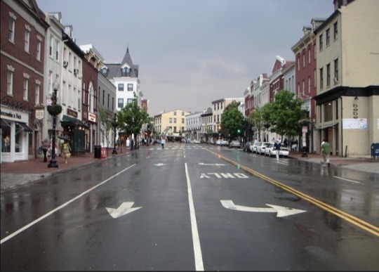
Siobhan Bracken: I am from Mentor, Ohio and I think the best Main Street in Mentor is Mentor Avenue. This is one of the most travel roads in Mentor, it hold most of the retail, restaurant, and bars. Mentor Avenue is not very walkable, it does have side walks lining the entire street but the blocks are very long and the buildings are set back far from the road and sidewalk. Additionally, there are bus stops along the street but very few have shelters. Mentor Avenue is a four lane road and runs the entire length of the municipality and is technically US route 20. Mentor Avenue has a historical district of Mentor and holds the majority of restaurants and shops in the area. Additionally, it has numerous grocery stores on the road. Mentor Avenue is the best example of a main street of my hometown Mentor, a large suburb of Cleveland. https://www.britannica.com/place/Mentor-Ohio
Trinity Finch: I am from Springfield, Ohio and just south is a village called Yellow Springs. I worked in Yellow Springs for most of my time in high school and some of the time in college. The Main Street there would be Xenia Ave, specifically the strip between Corry St. and Glen St. There are a number of small locally owned shops ranging from a grocery store, coffee shops, a flower shop, and art stores. The main street consists of four total lanes, with the two in the middle being driving lanes and the two on either side being parking lanes. I would like to add that Yellow Springs is surrounded by three national parks, as well as one of the longest bike trails in Ohio, so this village makes efforts to make sure that pedestrian quality is above average with wide sidewalks, awnings and trees that provide shade to those walking, crosswalks with flashing lights and law enforced speed reduction once entering the main street area. In the warm seasons almost every shop has their door open, restaurants have seating outside in the shade, and pop up shops are on every corner. Throughout all seasons, cold or hot, you will always see people out and socializing with shop owners, meeting up with friends, and meeting new people on the street.
Downtown yellow springs. Ohio. Find It Here. (n.d.). Retrieved March 29, 2023, from https://ohio.org/things-to-do/destinations/downtown-yellow-springs
Kayra Koprulu: I am from Cleveland Ohio. Now I am saying Cleveland because that is what most say when generally from that area, but I live in the city of Westlake which is probably around 30 minutes to downtown Cleveland. I live on Crocker Road. It is called Crocker road because there is a huge outdoor entertainment center right next to my neighborhood called Crocker Park. Crocker park is a very popular shopping and dining center. There are many different types of clothing stores, furniture stores, restaurants, coffee shops, and even grocery stores. Therefore, a lot of the population who live in and or around Westlake go there and they do this by taking Crocker Road. The outside of my neighborhood complex always has the busiest street, sometimes even more than downtown. There is always some sort of traffic, especially because a lot of people take that road to get to a variety of different places, not just Crocker Park. Alongside of this road, there is a big well known nursing home, restaurants (that are not actually inside of Crocker Park), fast food chains, and lots of neighborhoods and houses. All which bring together the conclusion of attracting people and to a busy street. In my opinion, most importantly, there are walkable sidewalks all along the road. They are bigger than normal sidewalks which I think is nice, because it is meant for bikers to use as well. This makes Crocker road sustainable for the majority of the public because they can get to their food, clothing, etc.. needs by walking or biking. I personally love living right by Crocker park and on Crocker road because I can walk when the weather is nice and it gives a sense of city life due to the high density in that area.
Crocker Park, Westlake Ohio
I am using the Short North Arts district from my hometown Columbus, Ohio as a good example of a main street. A successful main street should cater towards pedestrians, encourage a thriving social life and incorporate many mixed use building and planning techniques. I chose the Short North Arts District and specifically N High street which is the hot spot for many young college kids, and locals who live near this area, while additionally attracting people from the suburbs or travelers. If you had one day in Columbus you would want to spend it in and around this area. There are many unique shops such as thrift stores, local businesses and restaurants and chains that draw in people at all times of the day. This lively street is definitely catered towards pedestrians and the quality of their walking and browsing experience while allocating for the through traffic and buses. There are many plazas in this area and the use of outdoor seating, parklets, wide sidewalks, and general greenery that provides a median to the busy road makes it easy to enjoy whatever activity you're looking to do. The amount of lanes and parking spaces allocated is purposeful and nothing feels too crowded, which is important for pedestrian quality.
Gabriel Manzano
I am from Bethesda, Maryland which is located about 20 minutes from DC. A main street in my town is Wisconsin Ave which is a popular commercial and cultural street. Wisconsin ishome to a mix of businesses, including shops, restaurants, cafes, art galleries, and other services, which also makes it a popular Third Place. Many of the buildings along the street are multi-story, with retail or commercial space on the ground floor and offices or apartments above. The buildings are well-maintained and feature a variety of architectural styles, from modern glass and steel to more traditional brick and stone. Wisconsin with sidewalks dedicated to pedestrian crossings. The street is populated with plenty of street furniture to make it comfortable for pedistrians to walk and spend time there, and there is a lot of greenery to make the walk pleasant and enjoyable.
0 notes
Text
Blog #8
Find good examples of Main Street and Third Place in your neighborhood or hometown. Explain their conditions (in terms of building use, social life, and pedestrian quality).
Siobhan Bracken: I am from Mentor, Ohio and I think the best Main Street in Mentor is Mentor Avenue. This is one of the most travel roads in Mentor, it hold most of the retail, restaurant, and bars. Mentor Avenue is not very walkable, it does have side walks lining the entire street but the blocks are very long and the buildings are set back far from the road and sidewalk. Additionally, there are bus stops along the street but very few have shelters. Mentor Avenue is a four lane road and runs the entire length of the municipality and is technically US route 20. Mentor Avenue has a historical district of Mentor and holds the majority of restaurants and shops in the area. Additionally, it has numerous grocery stores on the road. Mentor Avenue is the best example of a main street of my hometown Mentor, a large suburb of Cleveland. https://www.britannica.com/place/Mentor-Ohio

Trinity Finch: I am from Springfield, Ohio and just south is a village called Yellow Springs. I worked in Yellow Springs for most of my time in high school and some of the time in college. The Main Street there would be Xenia Ave, specifically the strip between Corry St. and Glen St. There are a number of small locally owned shops ranging from a grocery store, coffee shops, a flower shop, and art stores. The main street consists of four total lanes, with the two in the middle being driving lanes and the two on either side being parking lanes. I would like to add that Yellow Springs is surrounded by three national parks, as well as one of the longest bike trails in Ohio, so this village makes efforts to make sure that pedestrian quality is above average with wide sidewalks, awnings and trees that provide shade to those walking, crosswalks with flashing lights and law enforced speed reduction once entering the main street area. In the warm seasons almost every shop has their door open, restaurants have seating outside in the shade, and pop up shops are on every corner. Throughout all seasons, cold or hot, you will always see people out and socializing with shop owners, meeting up with friends, and meeting new people on the street.

Downtown yellow springs. Ohio. Find It Here. (n.d.). Retrieved March 29, 2023, from https://ohio.org/things-to-do/destinations/downtown-yellow-springs
Kayra Koprulu: I am from Cleveland Ohio. Now I am saying Cleveland because that is what most say when generally from that area, but I live in the city of Westlake which is probably around 30 minutes to downtown Cleveland. I live on Crocker Road. It is called Crocker road because there is a huge outdoor entertainment center right next to my neighborhood called Crocker Park. Crocker park is a very popular shopping and dining center. There are many different types of clothing stores, furniture stores, restaurants, coffee shops, and even grocery stores. Therefore, a lot of the population who live in and or around Westlake go there and they do this by taking Crocker Road. The outside of my neighborhood complex always has the busiest street, sometimes even more than downtown. There is always some sort of traffic, especially because a lot of people take that road to get to a variety of different places, not just Crocker Park. Alongside of this road, there is a big well known nursing home, restaurants (that are not actually inside of Crocker Park), fast food chains, and lots of neighborhoods and houses. All which bring together the conclusion of attracting people and to a busy street. In my opinion, most importantly, there are walkable sidewalks all along the road. They are bigger than normal sidewalks which I think is nice, because it is meant for bikers to use as well. This makes Crocker road sustainable for the majority of the public because they can get to their food, clothing, etc.. needs by walking or biking. I personally love living right by Crocker park and on Crocker road because I can walk when the weather is nice and it gives a sense of city life due to the high density in that area.

Crocker Park, Westlake Ohio-Kayra Koprulu
I am using the Short North Arts district from my hometown Columbus, Ohio as a good example of a main street. A successful main street should cater towards pedestrians, encourage a thriving social life and incorporate many mixed use building and planning techniques. I chose the Short North Arts District and specifically N High street which is the hot spot for many young college kids, and locals who live near this area, while additionally attracting people from the suburbs or travelers. If you had one day in Columbus you would want to spend it in and around this area. There are many unique shops such as thrift stores, local businesses and restaurants and chains that draw in people at all times of the day. This lively street is definitely catered towards pedestrians and the quality of their walking and browsing experience while allocating for the through traffic and buses. There are many plazas in this area and the use of outdoor seating, parklets, wide sidewalks, and general greenery that provides a median to the busy road makes it easy to enjoy whatever activity you're looking to do. The amount of lanes and parking spaces allocated is purposeful and nothing feels too crowded, which is important for pedestrian quality.
Gabriel Manzano
I am from Bethesda, Maryland which is located about 20 minutes from DC. A main street in my town is Wisconsin Ave which is a popular commercial and cultural street. Wisconsin ishome to a mix of businesses, including shops, restaurants, cafes, art galleries, and other services, which also makes it a popular Third Place. Many of the buildings along the street are multi-story, with retail or commercial space on the ground floor and offices or apartments above. The buildings are well-maintained and feature a variety of architectural styles, from modern glass and steel to more traditional brick and stone. Wisconsin with sidewalks dedicated to pedestrian crossings. The street is populated with plenty of street furniture to make it comfortable for pedistrians to walk and spend time there, and there is a lot of greenery to make the walk pleasant and enjoyable.
0 notes
Text
Site visit picture!
Blog #7
Siobhan Bracken:
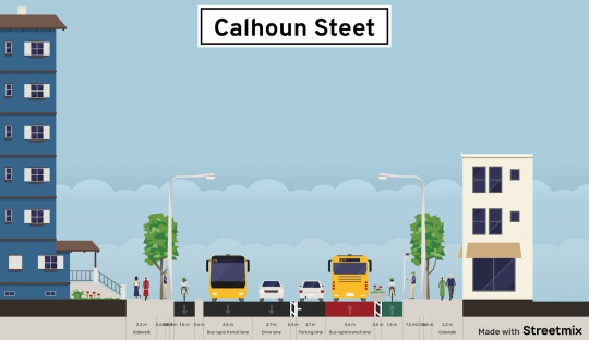
This is a proposed new perspective of what Calhoun Street could be in the CUF neighborhood. This design allows for more public transportation and cycling infrastructure. Although this does not include street parking, this area has many parking lots and garages. Calhoun street is a very busy place with lots of shops and restaurants, many students live around this area and it is filled with walking students. It is important to make this area more walkable and include more public transportation to connect the areas around UC more to the rest of Cinincinnati.
Trinity Finch:
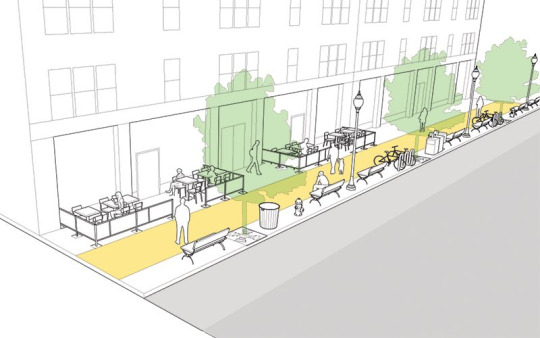
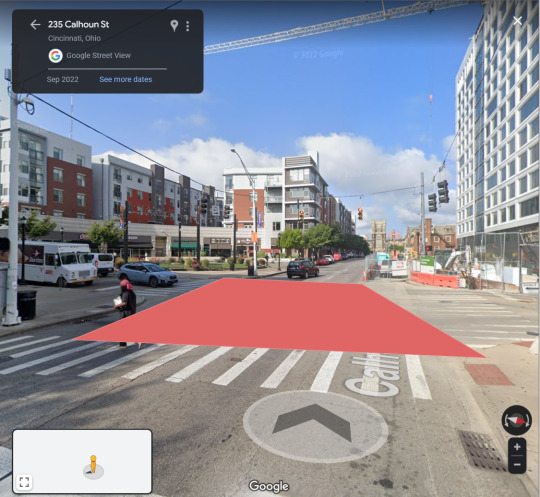
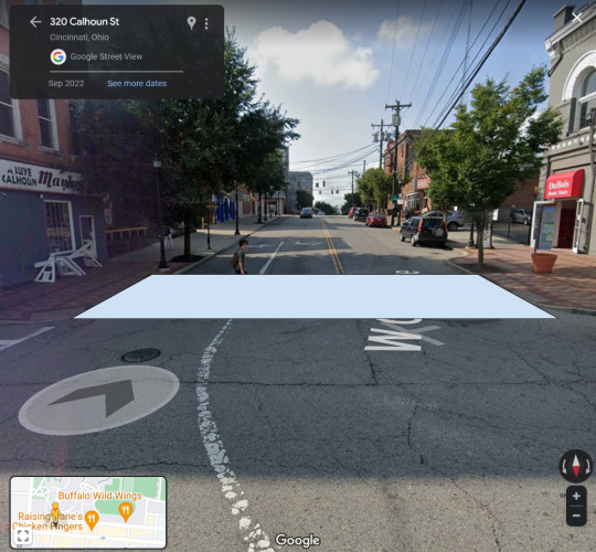
A good sidewalk should be a smooth and continuous pathway that is wide enough to accommodate everyone. It is recommended that a sidewalk should be at least 5 feet wide in order to allow two people to walk together and provide accessibility to those using wheelchairs or other needs. The street we chose was Calhoun and being right next to the University of Cincinnati and a very popular street, we can make this better. In the images below we can see the 5 feet path as well as a seating area, bike lane, and restaurant seating all together, this change can increase sociability, quality of life to college students and business to the store fronts and restaurants by campus. The only thing I would like to note that is not included in these diagrams would be placing awnings and trees along the side of the street and businesses to provide shade and shelter to rain and snow.
Ink, S. (2015, July 24). Sidewalks. National Association of City Transportation Officials. Retrieved March 22, 2023, from https://nacto.org/publication/urban-street-design-guide/street-design-elements/sidewalks/
Sophie Gartland:
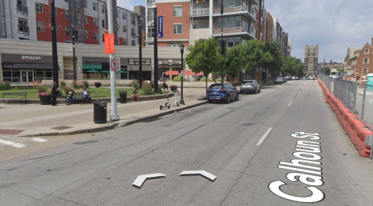
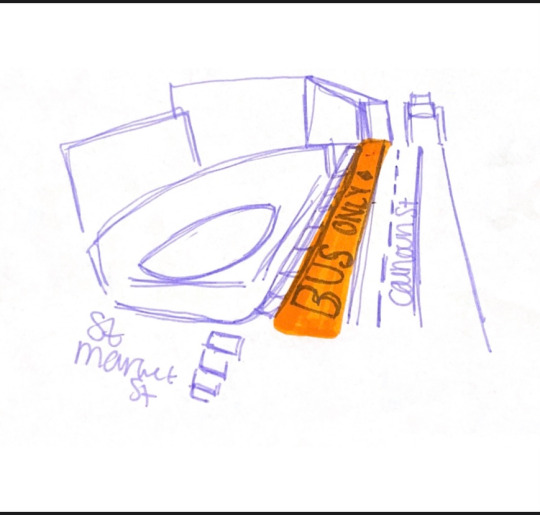
Focusing on Calhoun street and mainly the strip by the plaza that includes a Canes, Starbucks, Amazon Prime store and many other destinations that draw in college students and locals. There are many bus stops along Calhoun on both sides of the street that are frequently utilized by many. There are 8 bus stops from the point at which Calhoun and Scioto St intersect and McMillan St and Wheeler St. While there are many problems that this street presents because of how compact it is with the adjacent buildings and sidewalks, public transportation should be a priority. The addition of a bus lane would lead to more efficient loading and therefore decrease crowding on the sidewalks. The lane would begin where the strip for parking begins and go until the end of this street. This could be implemented in other areas as well, but putting a bus lane on this street should be a priority.
Gabriel Manzano:
On Calhoun Street there is a slight speeding problem that I have observed. I see drivers speeding down the two lane road, putting others in danger. Calhoun Street is a very popular road that always has heavy pedestrian or car traffic. An implementation that would promote safety on Calhoun would be to raise the crosswalks or install speed tables. The most ideal spots to add a speed table would be at the intersection of S Market St and Calhoun and maybe at the W Clifton Ave and Calhoun intersection. I believe the smart and ideal place to raise the crosswalk would be on the end of Dennis St where you turn onto Calhoun. These additions would be the best ways to enforce the speed limit while also making it safer for the students of UC and pedestrians of the Clifton area to walk on Calhoun St.
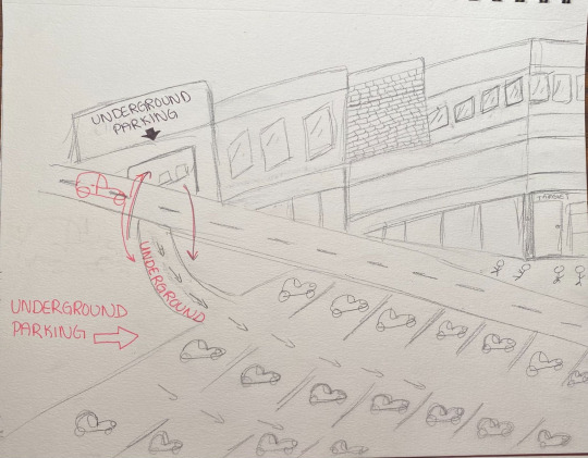
Kayra Koprulu: On the busy street of Calhoun, parking is an issue for many people. On a daily basis, most often all the street parking is taken, leaving people having to park in the few ground level garages there are. Most people can’t even afford parking at these garages, and usually it is very difficult to find a spot. A lot of students leave their cars at these garages overnight because they live close by, or even it is just taken up by random people who came there to either work, shop, and or eat out. I personally think that implementing more underground parking all along Calhoun and making it more affordable with more parking spaces would definitely benefit the majority of people. Or even making some of these underground garages just designated for students with a cheaper price. Obviously there is only so much space to put ground level garages, however underground parking is not utilized enough. It saves more space and makes Calhoun Street less clustered with buildings, but it also opens up more space for more of the public to utilize parking if they need to drive a vehicle there.
0 notes
Text
Blog #6
What are the barriers to TOD in America, and how can cities overcome this issue?
Support your view with a successful example of TOD (in or outside the U.S.)
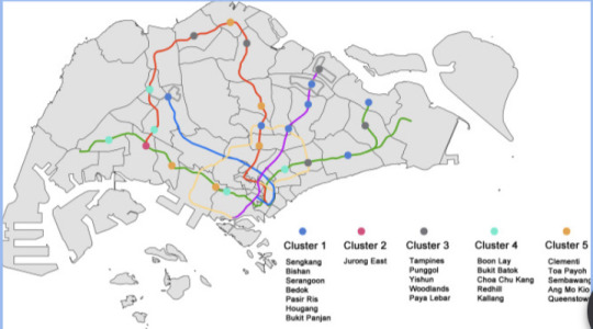
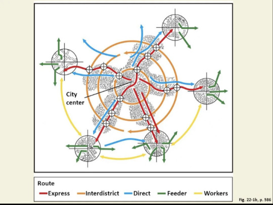
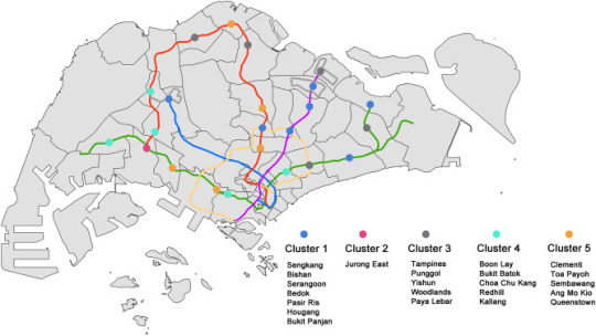
Sophie Gartland: Transit-Oriented development is the maximization of residential, business, and leisure space within a 5-10 minute walking distance of public transport. Essentially a well designed transit-oriented development is safe for bicycles and pedestrians, the reduction of vehicular traffic, and stations are directly integrated into downtown areas which may be easily accessed by foot, bike, bus and transit. TOD is so important because it encourages people to use other sources of transportation besides cars which is so impactful to our environment, alludes for more space for pedestrians and provides many other benefits to urban areas. Unfortunately there are some barriers to TOD in America. The automobile is one of the biggest competitors to transit oriented development and presents a barrier to users who would rather use a car than public transportation. Many people have the idea that public transportation is much less efficient compared to their cars, but that is most likely because they have never experienced effective public transportation. If everyone had access to successful TOD, people would begin to see the benefits it wreaks over automobiles and we would see a widespread use of TOD. In the United States, Washington D.C has an excellent system of bus and rail lines that make it a seamless transition for those who aren't used to public transportation, to utilize the bus or rail system as their primary source of getting around. Outside of the US, Singapore is an excellent example of TOD use in the means of promoting sustainability. Singapore has pods of dense areas, many with many amenities in walking distance, but all are connected by a rail system. In the figures below, the first image shows the spatial distribution and clusters. The second figure displays the performance factor or those clusters.
https://www.sciencedirect.com/science/article/pii/S2095263521000261#fig1
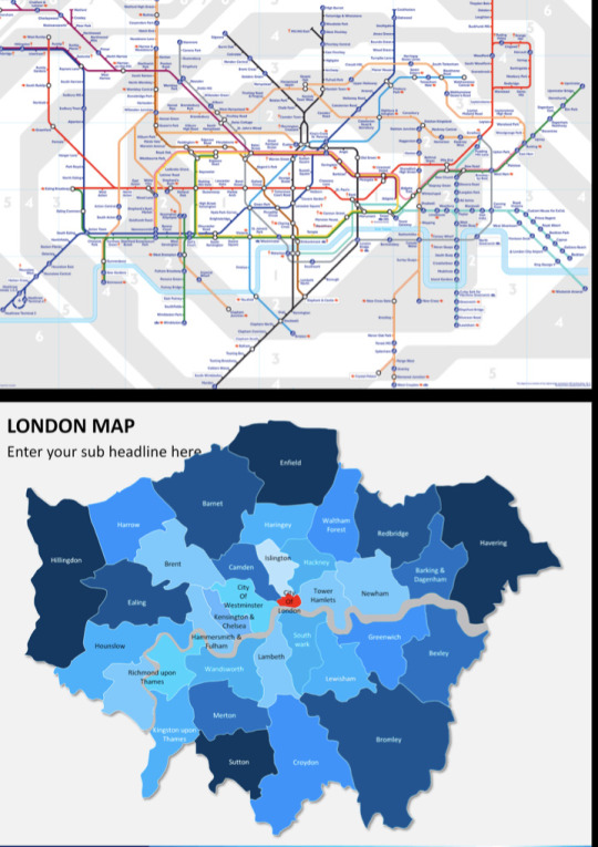
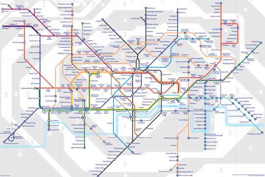
Siobhan Bracken: Transit Oriented Development is a theory of planning that prioritizes having walkable cities that allow people to walk from their homes to work, and entertainment. Additionally transit oriented development works on connecting public transportation to more people to achieve the goal of a fifteen minute city. The United States of America has prioritized designing cities and the country for cars for one hundred years and we are starting to undo the damage done such as building highways through low income neighborhoods, displacing people, increasing sprawl, and causing pollution. A barrier to transit oriented development is the funding and the precedent that cars are more important. Many cities or smaller towns do not have good public transportation if any because they do not have the budget to do so. A solution to this is for citizens to demand action from the local government to redo the budget and put money into adding bus lines or creating more public transportation. Citizens can ask from their local planning commission or local government officials to add these new public transportation options to improve their city and they also can create denser areas to make them more walkable. Continuing, towns can add more sidewalks to make it safer to walk to locations. London is a good example of a city that has transit oriented development. London’s expansive underground system makes it very easy to get all around the city. London is a geographically very large city but having a well developed and reliable public transportation system makes the city more livable and enjoyable. When cities make it easier to walk around or take public transportation, cities become more enjoyable by bringing live, work, and play to the individual.
https://www.bbc.co.uk/london/travel/downloads/tube_map.html
https://www.sketchbubble.com/en/presentation-london-map.html
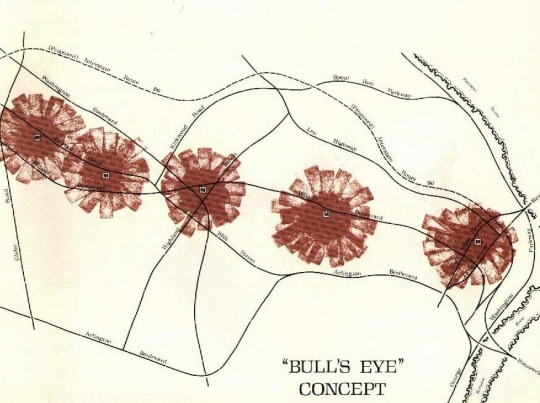
Trinity Finch: Land use and zoning often create barriers when it comes to creating and maintaining transit oriented development, or TOD, in American cities. By allowing room for flexible land use and providing more power to transit companies and agencies over station area land use we can theoretically overcome these barriers. Public agencies could try to focus on reducing development risk as well as press for systematic assessment of property value to increase. A successful TOD requires strategic planning. The needs and priorities for each station area needs to be provided for capital improvement plans and coordinate with all other system plans. The Rosslyn-Ballston corridor in Arlington, Virginia illustrates smart growth with their transit oriented development that focuses on high-density and mixed-use development. Arlington used a “bulls-eye approach” when planning their TOD (fig.1). With this approach it targets the tallest and most dense development within a quarter mile of each metro station. The rest of the United States needs to take notes from London as well as Arlington, Virginia in order to make cities that are not transit oriented like Houston and small cities more walkable and transit oriented.
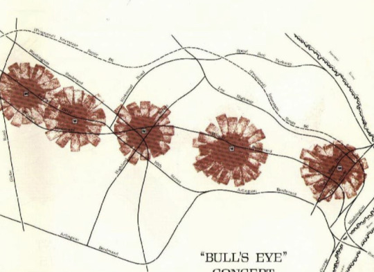
(fig.1)
Rosslyn-Ballston Corridor. – Official Website of Arlington County Virginia Government. (n.d.). Retrieved March 1, 2023, from https://www.arlingtonva.us/Government/Projects/Planning/Smart-Growth/Rosslyn-Ballston-Corridor
Gabriel Manzano:A place with an excellent example of successful TOD is the Curitiba Bus Rapid Transit system in Brazil. This system has TOD practically built into it; the mixed-use developments and residential buildings around the station reduce traffic congestion, improve access to jobs, and promote development in the city. To emulate the TOD that Brazil promotes, the US has to integrate TOD into new and already existing transportation projects, provide incentives, and reduce parking requirements.
From: https://solutionsclimatechange.com/pioneering-the-bus-rapid-transit-f1cd4159056e
Kayra Koprulu:
In conclusion, living in america can be beneficial for a lot of different things however it also can be inefficient for a lot as well. Inefficient as in the United States really prioritize car transportation when a lot of America is living in poverty and cannot afford the gasoline and or the car itself. Therefore being able to utilize more affordable transportation in a lot of areas, even if smaller, will impact a lot of people's lives. A successful TOD is in need of strategic planning. The public needs to demand for a change. For example, the government can put money into adding bus lines or creating more public transportation. Citizens can ask from their local planning commission or local government officials to add these new public transportation options to improve their city and they also can create denser areas to make them more walkable. Overall, we see more affordable and walkable transportation options in more European countries and or cities, but not nearly as much in America sadly.
0 notes
Text
Blog #6
What are the barriers to TOD in America, and how can cities overcome this issue?
Support your view with a successful example of TOD (in or outside the U.S.)
Sophie Gartland: Transit-Oriented development is the maximization of residential, business, and leisure space within a 5-10 minute walking distance of public transport. Essentially a well designed transit-oriented development is safe for bicycles and pedestrians, the reduction of vehicular traffic, and stations are directly integrated into downtown areas which may be easily accessed by foot, bike, bus and transit. TOD is so important because it encourages people to use other sources of transportation besides cars which is so impactful to our environment, alludes for more space for pedestrians and provides many other benefits to urban areas. Unfortunately there are some barriers to TOD in America. The automobile is one of the biggest competitors to transit oriented development and presents a barrier to users who would rather use a car than public transportation. Many people have the idea that public transportation is much less efficient compared to their cars, but that is most likely because they have never experienced effective public transportation. If everyone had access to successful TOD, people would begin to see the benefits it wreaks over automobiles and we would see a widespread use of TOD. In the United States, Washington D.C has an excellent system of bus and rail lines that make it a seamless transition for those who aren't used to public transportation, to utilize the bus or rail system as their primary source of getting around. Outside of the US, Singapore is an excellent example of TOD use in the means of promoting sustainability. Singapore has pods of dense areas, many with many amenities in walking distance, but all are connected by a rail system. In the figures below, the first image shows the spatial distribution and clusters. The second figure displays the performance factor or those clusters.
Siobhan Bracken: Transit Oriented Development is a theory of planning that prioritizes having walkable cities that allow people to walk from their homes to work, and entertainment. Additionally transit oriented development works on connecting public transportation to more people to achieve the goal of a fifteen minute city. The United States of America has prioritized designing cities and the country for cars for one hundred years and we are starting to undo the damage done such as building highways through low income neighborhoods, displacing people, increasing sprawl, and causing pollution. A barrier to transit oriented development is the funding and the precedent that cars are more important. Many cities or smaller towns do not have good public transportation if any because they do not have the budget to do so. A solution to this is for citizens to demand action from the local government to redo the budget and put money into adding bus lines or creating more public transportation. Citizens can ask from their local planning commission or local government officials to add these new public transportation options to improve their city and they also can create denser areas to make them more walkable. Continuing, towns can add more sidewalks to make it safer to walk to locations. London is a good example of a city that has transit oriented development. London’s expansive underground system makes it very easy to get all around the city. London is a geographically very large city but having a well developed and reliable public transportation system makes the city more livable and enjoyable. When cities make it easier to walk around or take public transportation, cities become more enjoyable by bringing live, work, and play to the individual.
Trinity Finch: Land use and zoning often create barriers when it comes to creating and maintaining transit oriented development, or TOD, in American cities. By allowing room for flexible land use and providing more power to transit companies and agencies over station area land use we can theoretically overcome these barriers. Public agencies could try to focus on reducing development risk as well as press for systematic assessment of property value to increase. A successful TOD requires strategic planning. The needs and priorities for each station area needs to be provided for capital improvement plans and coordinate with all other system plans. The Rosslyn-Ballston corridor in Arlington, Virginia illustrates smart growth with their transit oriented development that focuses on high-density and mixed-use development. Arlington used a “bulls-eye approach” when planning their TOD (fig.1). With this approach it targets the tallest and most dense development within a quarter mile of each metro station. The rest of the United States needs to take notes from London as well as Arlington, Virginia in order to make cities that are not transit oriented like Houston and small cities more walkable and transit oriented.
Rosslyn-Ballston Corridor. – Official Website of Arlington County Virginia Government. (n.d.). Retrieved March 1, 2023, from https://www.arlingtonva.us/Government/Projects/Planning/Smart-Growth/Rosslyn-Ballston-Corridor
Gabriel Manzano:A place with an excellent example of successful TOD is the Curitiba Bus Rapid Transit system in Brazil. This system has TOD practically built into it; the mixed-use developments and residential buildings around the station reduce traffic congestion, improve access to jobs, and promote development in the city. To emulate the TOD that Brazil promotes, the US has to integrate TOD into new and already existing transportation projects, provide incentives, and reduce parking requirements.
From: https://solutionsclimatechange.com/pioneering-the-bus-rapid-transit-f1cd4159056e
Kayra Koprulu:
In conclusion, living in america can be beneficial for a lot of different things however it also can be inefficient for a lot as well. Inefficient as in the United States really prioritize car transportation when a lot of America is living in poverty and cannot afford the gasoline and or the car itself. Therefore being able to utilize more affordable transportation in a lot of areas, even if smaller, will impact a lot of people's lives. A successful TOD is in need of strategic planning. The public needs to demand for a change. For example, the government can put money into adding bus lines or creating more public transportation. Citizens can ask from their local planning commission or local government officials to add these new public transportation options to improve their city and they also can create denser areas to make them more walkable. Overall, we see more affordable and walkable transportation options in more European countries and or cities, but not nearly as much in America sadly.
0 notes
Text
Blog #5
Blog Q#5
What are possible ways of alleviating the food insecurity problem in the Cincinnati area (including UC campus)? Support your answers with visual examples.
Sophie Gartland: Near UC’s campus and the Corryville area, there is pretty easy access to a nearby supermarket. But in West End Cincinnati, there are roughly 253 to 732 people in this low income area without access to a nearby grocery store. Cincinnati can adapt principles from Chicagos ‘Growing Power’ and ‘Fresh Bus’. With stops at schools (public schools, University of Cincinnati), medical centers and clinics, daycare centers, housing complexes, parks, and other spaces. I am connecting the West End desert area and the University of Cincinnati as an example in the graphic below:
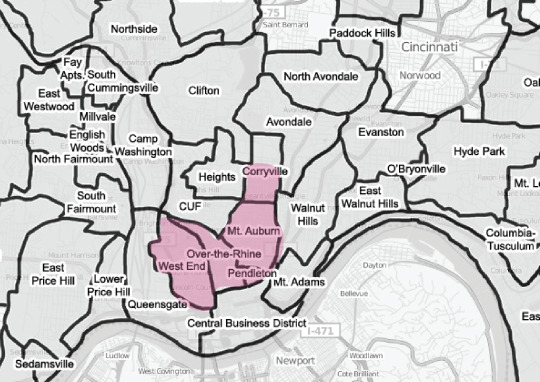
Image by: Sophie Gartland
Similarly to the bus in Chicago, Cincinnati could find an affordable way (by donation, etc) to convert a large bus into a means of transportation for fresh foods for University students and low income areas. Similarly to Chicago, Cincinnati's fresh bus will focus on the implementation of fresh produce; ‘kale and mustard greens, Honeycrisp and Cortland apples, cherry tomatoes and avocados. A refrigerated section offered salad mixes and fresh herbs: thyme, oregano, sage’ (Fresh Moves Delivers Vegetables to the South Side of Chicago by Bus).
Siobhan Bracken:
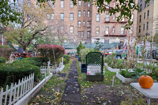
The issue of hunger in Cincinnati is a major issue, 28.7% of citizens of Cincinnati struggle with poverty. Those who struggle with poverty can not afford fresh fruits and vegetables and often do not have grocery stores in their neighborhoods. A solution to this issue is to encourage and create community gardens. Urban farming and community gardens are wonderful ways to increase the amount of fresh produce and make it accessible to all. Community gardens allow for the neighborhood to be connected to the food they eat. Additionally, this would increase the amount of healthy food available to people in Cincinnati. Urban farming also decreases the amount of fossil fuels used to transport produce. Overall urban farming and community gardens are good for the community and for the planet.
Trinity Finch: Mobile markets and grocery carts have the ability to serve communities on a rotating basis. With that being said, grocery carts can serve many communities in a short span of time. They are low cost and easy to access for the communities around them. In food deserts where access to healthy food is limited and people may have to travel long distances to access grocery stores that have fresh food, mobile markets can provide those necessities to everyone. Here in Ohio, there is already practice of these mobile markets. In Cleveland the Bridgeport Mobile Market travels to people's living spaces, work areas, as well as places of worship to bring fresh fruits and vegetables to their communities. There are only four main steps to starting your own mobile market: relying on proven business strategies, researching successful mobile markets, developing private partnerships for funding, and developing financing packages for each mobile market project. With these steps in mind, we can reduce food deserts in our communities.
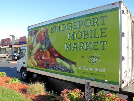
Debbi Snook, T. P. D. (2013, June 26). Produce truck to serve Cleveland's 'food deserts'. cleveland. Retrieved February 21, 2023, from https://www.cleveland.com/taste/2013/06/produce_truck_to_serve_clevela.html
Gabriel Manzano: Vertical farming is a type of indoor farming system that involves growing crops in vertically stacked layers using advanced technologies like hydroponics, aeroponics, and artificial lighting. This system can alleviate the food insecurity problem in the Cincinnati area and UC campus by providing year-round crop production, efficiently using space, and reducing transportation cost. Vertical farming allows for year-round crop production, regardless of weather conditions. This can help provide a consistent and reliable source of fresh produce, which can be especially important in areas with harsh or inconsistent winters, like Cincinnati. Vertical Farming also reduces transportation cost because the crops are grown locally. This can help make fresh produce more affordable and accessible to local residents, including those on the UC campus. Vertical farming helps provide a reliable source of fresh produce which increases food security by ensuring that there is a consistent supply of fresh produce available, regardless of external factors.
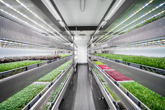
(https://wikifarmer.com/what-is-vertical-farming/)
Conclusion: Kayra Koprulu
In conclusion, there are a variety of ways to reduce the food insecurity problem in the Cincinnati area (including UC campus). These ways being bus transportations to local fresh food supermarkets, creating community gardens, and mobile markets. While these options are not the only ones, there are many more to list. These acts of service can easily be funded by donations if the public is willing to help. Other ways that can be implemented to benefit Cincinnati and even other poverty stricken cities could be raising awareness to donate to local food banks and building up more food banks in more cities and even towns. Even something as easy as making go fund-me type donation foundations and raising awareness on social media platforms by posting their links. It’s easy and quick to click a link therefore, more donations can be made. More and more accessible places for people who struggle to get healthy and nutritional foods will be possible, but only with the help of the public to support.
-Kayra Koprulu
Question: What can the city of Cincinnati do to encourage companies like kroger to move into food deserts?
0 notes
Text
Blog #4
What types of regional and local transport(s) does Cincinnati need more in the future? Explain why.
• Streetcar / Light rail
• BRT (Bus Rapid Transit)
• Bike-share
• Subway
• Monorail (Cable car)
• High Speed Rail
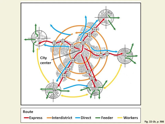
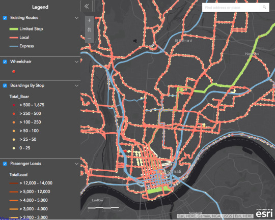
Sophie Gartland: Currently Cincinnati’s transportation mainly revolves around the Cincinnati Metro Bus, the Bell Connector, uber/lyft, and some bikeshares. Ultimately, the best way to get around Cincinnati is by car and the bus would be the second best option. The image below shows how many ride the Metro, and where. There are some pedestrian friendly neighborhoods including Hyde Park, Over-The-Rhine, and the campus area. But the city in general is not walkable enough, especially when going from neighborhood to neighborhood. Our group members examined the status of the current transportation and what can be implemented in the future to improve efficient transportation around the city. We looked at ways in which subway, high speed rail, and bikeshare systems can improve transportation for both travelers and residents of Cincinnati.
Siobhan Bracken: Cincinnati and the entire state of Ohio could benefit from high-speed rail infrastructure being built. High speed rail would allow people from Cincinnati to travel long distances with low environmental impact and at a lower cost. There have been proposed plans of building high speed rail connecting the major cities in Ohio: Cleveland, Columbus, and Cincinnati. This would benefit much of the state by making it easier to travel from south west Ohio to north east Ohio. Additionally, with the increased investment of jobs in central Ohio, a high speed rail system would encourage tourism and Cincinnati and Cleveland would also benefit from this influx of people and jobs. Cincinnati needs high speed rail to encourage environmentally friendly forms of transportation at a low cost.

Trinity Finch: Subways can significantly improve the average commute times, help people efficiently travel around the city to get where they need to be while spending much less money on commuting. There are a number of advantages to the subway would include the environmental gains, higher safety of the general traffic, and increased demand and attracting car users, which all around would increase walkability and general safety of the people not using cars or not having access to car transportation. Actually, Cincinnati is home to the largest unused subway system in the world with over two miles of empty tunnels. With that being said, we already have the layout to continue that subway system. Cincinnati would benefit from this system of underground subways because of the vast amount of hills and obstacles that the subway can avoid. The map below shows the current abandoned subway system that Cincinnati possesses, as stated before with this layout, a city budget and fund, it is possible to continue the 1927 subway system dream.
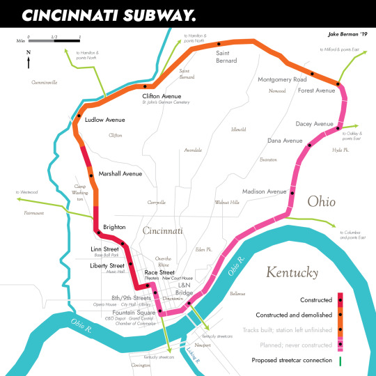
Work Cited: The Cincinnati Subway. Home - City of Cincinnati. (n.d.). Retrieved February 15, 2023, from https://www.cincinnati-oh.gov/dote/about-transportation-engineering/historical-information/the-cincinnati-subway/
Body paragraph: Kayra Biking
Most of Cincinnati is actually walkable which is the cheapest option a pedestrian could choose when going from place to place, however the safety aspect is questionable. Most areas in Cincinnati are not the safest especially when walking alone. Therefore the second cheapest option would be biking. It is a faster and safer way of getting around. Sadly, in most parts of Cincinnati I have seen, the bikers are usually on the sidewalk, not on paths on the road. There are barely designated paths for those who want to use them and even if there are, most of the paths are blocked by parked cars. The result of this is less peo0ple utilizing biking and the little people who do bike have to go on the sidewalk blocking the walkways of pedestrians. Now all of that said, obviously it is not the safest biking on a busy city road, but the less busier areas of Cincinnati can definitely invest in more on road bike ways. For example, around campus I barely see people biking when it could actually save them time and keep them safer. A great example of a place that really utilizes biking would be the Netherlands which I find intriguing. Traffic rules there are so bike-friendly that the Dutch don't even need helmets. The cycling infrastructure in the Netherlands is so well thought out that cycling accidents are surprisingly few, especially considering how many people bike.I think having more bicycle paths on the sides of the road would be very beneficial for the city of Cincinnati for efficiency.
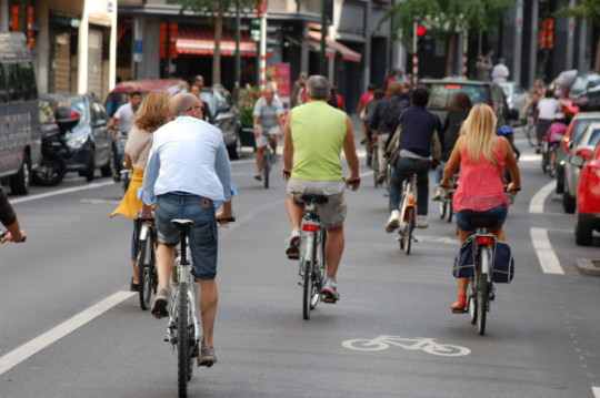
People in the Netherlands biking on the road whereas in Cincinnati
It would be very dangerous to do so.
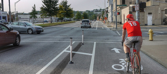
These are the types of off side paths Cincinnati should include more of
Especially around campus areas and lower traffic areas.
Gabe: In conclusion, Cincinnati’s current transportation options mainly consist of the Metro Bus, Bell Connector, uber/lyft, and some bikeshares. Although the city is not very walkable, there are some pedestrian-friendly neighborhoods. While driving is the most efficient way to get around Cincinnati, it is neither environmentally friendly nor cost-effective. High-speed rail infrastructure and subways are proposed solutions that could significantly improve transportation efficiency, reduce environmental impact, and increase safety. Biking is a cheaper option than driving or taking public transportation, but the lack of designated bike paths and safety concerns make it a less popular choice. Overall, it is critical for Cincinnati to invest in efficient, cost-effective, and environmentally friendly transportation options to enhance the city's walkability and overall quality of life.
0 notes
Text
Blog #3
What’s the “best” density for the design of cities today? Why?
Find an example(s) of the city block that has the best density in Greater Cincinnati.
Measure its density in housing units per acre and FAR and provide supporting images (aerial photos, street photos, sketches, etc.)
Intro: Sophie Gartland
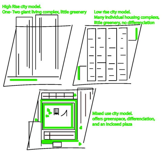
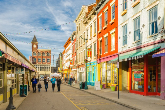
Density is mostly a good thing in cities as it helps keep areas walkable and therefore affordable for all classes of people. Cities should have never been structured around cars the way they were, because that has led to so many deep rooted issues with city designs today that would be difficult to reverse. Many Americans may prefer to live in a sprawled suburb with low density detached houses because they could value aspects such as privacy, which you have less of in denser areas. With a proper and comfortable design for its residents, somewhere between 30 to 52 units per acre is the best density for cities today. But the quality of life ultimately relies on the design of the city. With the implementation of an abundance of greenspace; green infrastructure, public gardens, parks and plazas, residents should enjoy the benefits they receive from living in a densely populated area. The city will also reap environmental benefits ultimately relating back to the quality of life for its’ residents. Looking at city blocks in Cincinnati such as OTR, and it's’ FAR and qualities that make it so enjoyable for its’ residents and tourists.
Body 1: Trinity Finch
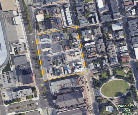
Image by Trinity Finch
Body: Siobhan Bracken
Density is incredibly important for cities. The concept of a fifteen minute city relies on density. Having all essentials close by is important for daily life. The ability to walk, bike, or take public transport to work, school, shops, and restaurants makes life more convenient and enjoyable. Having 30 units per acre makes the city medium density, this means that a community is mixed use while also preserving privacy that many people appreciate. Areas in Cincinnati that have really good density are Over the Rhine because they have many mixed use areas with close proximity to green space and parks. Additionally, OTR has other communal areas that can be used for community gathering that are not green space but encourage social interaction, for example Findlay Market.
Body: Gabriel Manzano
Today, there is a debate about the best density for the design of cities among urban planners and architects. Some argue that high density is the ideal city as it allows for efficient use of resources, reduces pollution from transportation, and walkability and social interaction. On the other hand, others believe that low density is better for cities as it leaves more space for greenery and privacy. Again, OTR is an optimal neighborhood due to the density of it. Its design allows for a good mix of residential, commercial, and walkable uses. Along with the efficient design, there are also a good amount of areas that allow for social interactions.
Conclusion: Kayra
In conclusion, density is more beneficial than unbeneficial to the overall population. Being able to go to places people one loves in an affordable place is something a lot of people desire and even need. Not just walking to places you love but being able to walk to your daily needs. Daily needs as in schools, hospitals, libraries etc. Being able to access a necessity without having to spend money on it is what a lot of cities need, especially the cities facing more poverty. Density also provides other transportation opportunities in a sustainable way, which has positive effects as one would expect.
0 notes
Text
Blog #2
What are lessons from Paris and Chicago that Cincinnati can emulate?
Mention specific parts that you learned from Haussmann's plan.
Intro:
In a city, there is not just one standard type of style everyone enjoys to live in. There are multiple. Finding that compromise is something Haussmann did. He showed everyone that unity was key to a successful environment/city. Having a place where everyone can come together and or just enjoy is key. This unity factor is very present in Paris and Chicago, and hopefully can be present in the city of Cincinnati. (Kayra)
Unity:
One of Haussmans main goals in his reformation of Paris was to rebuild the city with unity. Haussmen gave Paris order and structure with the implementation of strategically placed boulevards and neighborhoods. Over the Rhine is a very popular part of Cincinnati that attracts lots of locals, and out of state visitors for its vibrant nightlife and variety in restaurants. The Over the Rhine and Findlay market area of Cincinnati has been built up over the years to what it is now; safe and friendly. With that being said, walking just a few blocks over from Findlay Market can leave you surrounded by abandoned buildings and neglected streets. Because of this it makes it extremely difficult to get from place to place without a car in the general Over the Rhine area due to safety concerns. These neglected streets are lacking many of the principles of Haussmannization; wide streets, green spaces, cafes and storefronts, etc. Unfortunately it is difficult for the city of Cincinnati to implement some of Haussman’s ideas to bring life to the neglected parts of the city because they could face being accused of gentrification, similarly to Haussman. There are some things that could be done to unify the run down neighborhoods of Cincinnati with the urban, pedestrian filled areas. Some ideas could be, reviving the rundown buildings into connected housing developments and enhancement in the streets. Using Haussmens principles the city could make the streets wider, and add medians with lots of trees and greenspace. (Sophie G)
Road and Building density:
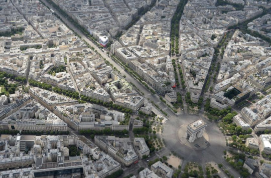
Haussmannization of cities involve creating large boulevards for fresh air and light. In the reconstruction of Paris and Chicago, widening the roads and creating boulevards turned the cities into what they are today, not only that but also demolishing buildings and rebuilding to rid of the thick urban fabric that coated the cities. With these in mind, Cincinnati would learn from these reconstructions and practice Haussmannization. Specifically looking at Over the Rhine and the University of Cincinnati area, we see a lot of urban fabric, skinny roads overlooking sharp turns, steep hills, as well as potholes from poor development. If the city were to focus on accenting sculptures and lead thick roads to tourist points, give the people wide boulevards to bring business to plazas and small local businesses there could be a boom in activity downtown as well as an increase in profit for those local businesses. We would also find and increase in air quality and could possibly reduce the idea of a heat island around the downtown Cincinnati area. Looking at lessons learned from Chicago, Cincinnati could benefit from demolishing small, clustered buildings and focus more on buildings that go with the city and get rid of the thick building density.
Connection to landmarks:
Conclusion:
In conclusion, Cincinnati has many ways it could emulate what Paris and Chicago did including creating unity by implementing boulevards and destroying and rebuilding buildings to bring energy and business into downtown. Leading these new boulevards to city landmarks and tourist attractions would reflect what Haussman practiced. If these steps were to be take, they would help the city feel more connected, safe, and enjoyable. (Gabe)
0 notes
Text
Urban Schemers and Plotters post 1/18/23
URBAN S&P
Blog # 1
For you, what is an “ideal” city? Does an example exist? Support reasons in relation to one of the three utopian ideas (Howard, Corbu, Wright)
Intro:
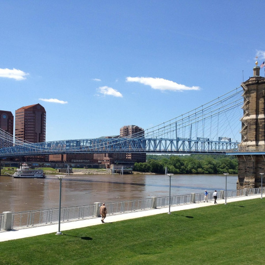
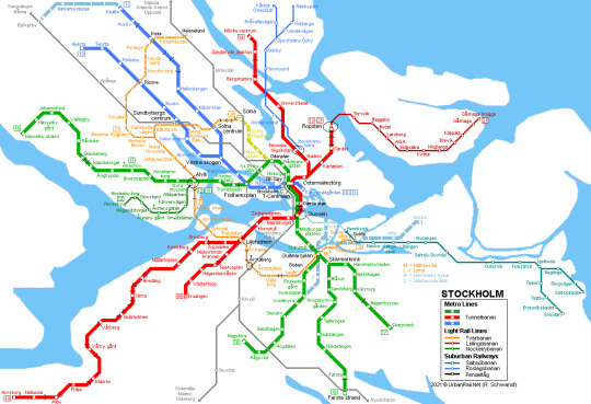
The characteristics that make up ones’ ‘ideal city’ can be very complicated but should aim to fit the overarching goals for the city's foreseeable future. Looking at Howard, Corbusier, and Wright's Utopian cities, you can get a sense of what each of their focus was on each city; what was most important to them and what was least important to them. An ideal city might be different for everyone, however one most can agree on would be the city of Stockholm. (Kayra)

Transportation:
Stockholm is an ideal city due to its convenient and affordable transportation options. Ebenezer Howard’s idea of the garden city provided an idea of a city that was self-sustaining and compact and easy to get around in. This is similar to Stockholm because of the widespread availability of public transportation options such as trains and buses. Continuing, since the garden city is fairly isolated due to the three magnets of a city, Stockholm has public transportation options to travel to other cities by ferry, train, or bus. By creating a dense, convenient, and easily navigable city, Stockholm displays some similarities to the garden city Howard explains and also expresses how it is an ideal city. (Siobhan Bracken)
Savage, Maddy. “How to Get around in Stockholm.” Lonely Planet, 3 Aug. 2022,
https://www.lonelyplanet.com/articles/getting-around-stockholm.
Sustainability:
Similarly to Ebenezer Howard’s Garden city, the city of Stockholm is well known for not only its abundance of green space and walkability but the effort the city has made to reduce pollution. With the city's new innovation, they are able to foster a large population while maintaining a safe, comfortable, and family friendly area. That concept builds upon similar principles to Howard's Garden City. Another one of Howards fundamental ideas for his garden city was to create a smokeless environment by keeping the factories on the outside ring of the city and housing people more towards the center. For many years Stockholm has been ambitious about becoming fossil free in the upcoming years……. Stockholm is aiming for net zero emissions by the year 2040, and has already been taking action for years. They plan to begin replacing fossil fuels with renewables and aim to phase out coal by 2022 (Strategy for a fossil-fuel free Stockholm by 2040). Both Stockholm and the garden city are based on the core ideas of ensuring comfort for its residents by having core-urban spaces, and clean air free of emissions. (Sophie)
Ideal City:
Much like Howard’s Green City, Stockholm is among the top few cleanest cities in the country. As stated previously, one of Howard’s fundamental ideas for the Green City was to make sure that factories and major industries were on the outside ring of the city, though Stockholm does not have that outer ring, the city still makes an effort in reducing polluted air for the safety of their people. Parks and green areas are open to the public and act as Stockholm’s green living room. With the effort in sustainability put forward for the people of Stockholm, it is clear that this city prioritizes the long term health and safety for not only the people of Stockholm, but they are putting on a display for the rest of the world to follow. (Trinity)
Start - city of Stockholm. (n.d.). Retrieved January 18, 2023, from https://international.stockholm.se/globalassets/ovriga-bilder-och-filer/stockholm-a-sustainably-growing-city.pdf
Conclusion:
While everyone has their own ideal city, one that a majority of people can agree on would be Stockholm. Whether that be the beautiful sites, or whether it be the easy travel, there is almost nothing to dislike. While being one of the cheapest cities in the world, it is also one of the cleanest ones as well which is something a lot of people look for when searching for a place to live in. In conclusion, the city of Stockholm is definitely one that is not spoken about enough! (Kayra)
Question….
How can North American cities implement systems in place that Stockholm has to create ideal cities?
Images & Question: Gabe
1 note
·
View note