#aerialimaging
Text
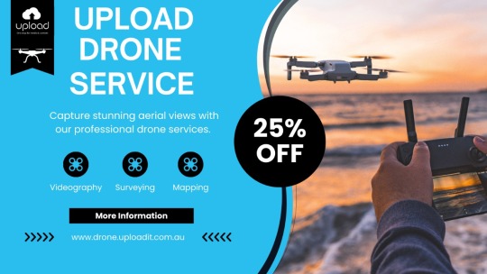
Ready to take your projects to new heights? Discover the magic of our drone services, tailored for videography, surveying, and mapping! 📽️🌍
With our professional drone services, you can capture breathtaking aerial views including:
Videography
Surveying
Mapping
Our drones are equipped with cutting-edge technology to bring your projects to life. Reach out today and let us turn your ideas into reality! Also, we have 25% off right now.
📞 Ph: +61-401957996,
📧 Email: [email protected]
🌐 Website: https://drone.uploadit.com.au/
📧 Facebook: https://www.facebook.com/UploadMediaServices/
📷 Instagram: https://www.instagram.com/upload_mediaservices/
🎥 TikTok: https://www.tiktok.com/@uploadit.com.au/
#droneservices#dronesurveying#dronemapping#dronevideography#aerialimaging#ElevateYourView#CaptureFromAbove#AboveAndBeyond
0 notes
Photo

Visiting SD County Sheriff! TAKE FLIGHT 📞 +1 818-906-4024 www.corsairaviation.com #cessnapilotcenter #textronaviation #specialmissions #txtavlife #part135 #airtaxi #aerialimaging #aerialphotography (at Gillespie Field) https://www.instagram.com/p/CgC9mphPhpP/?igshid=NGJjMDIxMWI=
#cessnapilotcenter#textronaviation#specialmissions#txtavlife#part135#airtaxi#aerialimaging#aerialphotography
1 note
·
View note
Text

Elevate Your Project with Expert Aerial Image Annotation Services!
🔍 High-Quality Annotations: From object detection and tracking to semantic segmentation, we provide accurate annotations that fuel your AI and machine learning projects.
🌐 Diverse Industries: Whether it's agriculture, urban planning, disaster response, or more, our annotations enhance your aerial images for impactful insights.
⏱️ Rapid Turnaround: Tight deadlines? No problem! We deliver on time without compromising quality.
🛡️ Data Security: Your data's safety is our priority. We ensure strict confidentiality throughout the annotation process.
🧠 Customizable Solutions: Tailored to your project's unique needs, our annotations boost your algorithm's performance and results.
🌟 Trusted Expertise: Our experienced annotators ensure meticulous detailing, guaranteeing robust AI model training.
Level up your aerial imagery projects today. Contact us for precise annotations that fuel innovation and drive results! [email protected]
#machinelearning#imageannotation#artificialintelligence#dataannotation#datalabeling#boundingbox#lowcostannotation#annotationservice#aerialimageannotation#aerialimages#aerialdatasettraining#aerialvideoannotation#wisepl#ai
0 notes
Photo

Big thank you to the lovely person from the UK 🇬🇧 for picking out this Canvas Print of Marlborough Buildings - Aerial Image of Bath, Somerset, UK today ❤️. I hope you are delighted with your print 😊 #CanvasPrint #MarlboroughBuildings #AerialImage #Bath #Somerset #UK #aerialphotography #ballooning #shotfromaballoon #heidiannemorris #redbubble #redbubbleartist #Architecture #aerialArchitecture #england (at Marlborough Buildings) https://www.instagram.com/p/CpF_ZPpMibb/?igshid=NGJjMDIxMWI=
#canvasprint#marlboroughbuildings#aerialimage#bath#somerset#uk#aerialphotography#ballooning#shotfromaballoon#heidiannemorris#redbubble#redbubbleartist#architecture#aerialarchitecture#england
0 notes
Photo

... amb aquestes imatges aèries d'alta qualitat podras assegurar que tot estigui en ordre en un temps rècord! Seguim treballant... #drone #dron #drons #dronservice #dronscatalunya #kpsdrons #imatgesaeries #aerialimages https://www.instagram.com/p/Cih8tDgNfjL/?igshid=NGJjMDIxMWI=
0 notes
Photo

Goodmorning!! We’re officially halfway through the week, how’s everyone doing so far? ➢ Credit 👉🏆📸 @mylesperhour_photography . . ➢ Follow 👉 🇺🇸@conexao.america for more photos and movies about United States 🇺🇸 . . . ➢ Alliance @america_states @enjoy_la_ @latinbrazil . . . ➢ ✈ Mark your photo with tag #conexaoamerica or @conexao.america and we'll post it! . . . . #clt #charlotte #charlottenc #cltnc #cltskyline #discoverclt #charlottesgotalot #cltguide #skyline #sunset #citylife #charlottephotographer #sonyalpha #cltartist #southendclt #uptowncharlotte #uptownclt #mavic3 #dji #aerialimages #mavic #drone (em Charlotte, North Carolina) https://www.instagram.com/p/Cp0FaDdrky6/?igshid=NGJjMDIxMWI=
#conexaoamerica#clt#charlotte#charlottenc#cltnc#cltskyline#discoverclt#charlottesgotalot#cltguide#skyline#sunset#citylife#charlottephotographer#sonyalpha#cltartist#southendclt#uptowncharlotte#uptownclt#mavic3#dji#aerialimages#mavic#drone
1 note
·
View note
Video
About 1am on 6/4 a missing suicidal man entered the sea at Filey, North Yorkshire. A patrol of the beach failed to locate him. This video shows the moment he was walked up the beach after an NYP drone pilot spotted him with a thermal camera and he was pulled out! . . . . . . #dronesforgood #marketing #Repost #overlap #maps #drones #geo #orlandoflorida #miamiflorida #drone #dronegram #mapping #data #aerial #aerialimaging #gis #map #viewfromabove #droneoftheday #photogrammetry #bigdata #uas #dronepilots #fromwhereidrone #lookingdown #topdown #changemakers #instadrone #dronejobs (at West Kendall) https://www.instagram.com/p/BwpXe5TAg76/?utm_source=ig_tumblr_share&igshid=vbhznezli5f3
#dronesforgood#marketing#repost#overlap#maps#drones#geo#orlandoflorida#miamiflorida#drone#dronegram#mapping#data#aerial#aerialimaging#gis#map#viewfromabove#droneoftheday#photogrammetry#bigdata#uas#dronepilots#fromwhereidrone#lookingdown#topdown#changemakers#instadrone#dronejobs
1 note
·
View note
Photo

Stock aerial images of the Savannah river in Savannah, Georgia. Using boats on the Savannah river. ©Paul Todd/OUTSIDEIMAGES.COM OUTSIDE IMAGES PHOTO AGENCY . . . . . #savannah #dronelife #stockimages #lowcountry #aerialimaging
1 note
·
View note
Photo

Another memorable winter sunset in the Hamptons. #sunset #sunset_hub #sunsetphoto #hamptons #winterlight #shinnecockbay #duneroad #aerialphotography #aerialphoto #aerialimaging #aerialview #aerialperspective #droneview #dronephotography #droneoftheday #droneshot #dronestagram #dronephotographer #dronephoto #djiphantom4pro #djiphantom4 #djicreator #djidrone #goldenhour #bluehour @hamptonsmag @hamptons @djiglobal @droneoftheday @djiusa (at Hampton Bays, New York)
#djiphantom4pro#hamptons#droneoftheday#bluehour#djidrone#aerialphotography#djicreator#sunset#djiphantom4#aerialimaging#shinnecockbay#sunsetphoto#droneshot#duneroad#dronestagram#aerialview#droneview#goldenhour#dronephotographer#aerialperspective#sunset_hub#winterlight#aerialphoto#dronephotography#dronephoto
1 note
·
View note
Photo
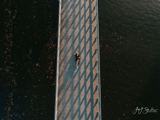
Serenity. . . . . #Aerial #aerialmovies #aerialsilksposes #aerialfootage #aerialgirls #aerialyogateacher #aerialtrick #aerialranch #aerialyogagirl #aerialaspects #aerialtissue #aerialfun #aerialforinstagram #aerialimaging #aerialyogahammock #aeriallyra #aerialfitness #aerialmob #aerialistsoutdoors #aerialfilming #aerialacrobatics #aerialartists #aerialyogabrasil #AerialAtom #aerialvisionimaging #aerialjakarta #aerialphotographyphantom #aerialcreation #aerialistofig #aerialtanker (at Schuylkill Banks Boardwalk) https://www.instagram.com/p/B5B3DgcDD53/?igshid=1nhq7c3vrqvie
#aerial#aerialmovies#aerialsilksposes#aerialfootage#aerialgirls#aerialyogateacher#aerialtrick#aerialranch#aerialyogagirl#aerialaspects#aerialtissue#aerialfun#aerialforinstagram#aerialimaging#aerialyogahammock#aeriallyra#aerialfitness#aerialmob#aerialistsoutdoors#aerialfilming#aerialacrobatics#aerialartists#aerialyogabrasil#aerialatom#aerialvisionimaging#aerialjakarta#aerialphotographyphantom#aerialcreation#aerialistofig#aerialtanker
0 notes
Text
Aerial Imaging Market Expected to Reach USD 2.24 Billion by 2020: Grand View Research, Inc.
The global Aerial Imaging Market is expected to reach USD 2.24 billion by 2020, according to a new study by Grand View Research, Inc. Growing demand in emerging application areas including natural resources management, energy, and disaster prevention is expected to drive the market over the next six years. Increased need for geospatial information and imagery data is also expected to fuel demand over the forecast period.

Adoption of location-based services (LBS) for navigation, remote monitoring, navigation and mobile advertizing is expected to give impetus to the aerial imaging market. Adverse weather conditions and related environmental factors may prevent accurate imaging data collection. Security and privacy concerns among users are also expected to hamper market growth over the next six years.
To request a sample copy or view summary of this report, click the link below: http://www.grandviewresearch.com/industry-analysis/aerial-imaging-market
Further key findings from the study suggest:
Commercial applications are expected to witness high growth over the forecast period; they accounted for over 15% of the market in 2013. This can primarily be attributed to high adoption by the tourism industry. Planning 3D or 2D seismic surveys for alleviating safety and environment risks is expected to favorably impact the energy segment.
Aerial construction progress images are used by architects and engineers for infrastructure development activities. Deploying aerial drones in place of manned helicopters for reducing overall cost is expected to be a key growth opportunity. The agriculture sector benefits from this technology through application in drainage planning and farmland management.
North America accounted for majority of the global market share in 2013. High demand from the agriculture and forestry segment is expected to be the chief growth driver for the regional market. Demand from government agencies employing this technology for research purposes is also expected to fuel the market over the next six years. High demand across application areas is estimated to propel the Asia Pacific aerial imaging market.
Companies operating in the aerial imaging market may have in-house systems and platforms; alternatively, they may also procure these from suppliers. Continued investments in R&D and technological innovation have been the key strategic initiatives undertaken by major industry participants. Key market players include Blom ASA, Fugro EarthData, Google Inc, Pictometry International, GeoVantage, Inc., Kucera International, Digital Aerial Solutions, Ofek Aerial Photography, Eagle View Technologies, etc.
See More Reports of This Category:
https://www.grandviewresearch.com/industry/emerging-and-next-generation-technologies
About Grand View Research:
Grand View Research, Inc. is a U.S. based market research and consulting company, registered in the State of California and headquartered in San Francisco. The company provides syndicated research reports, customized research reports, and consulting services. To help clients make informed business decisions, we offer market intelligence studies ensuring relevant and fact-based research across a range of industries, from technology to chemicals, materials and healthcare.
0 notes
Photo
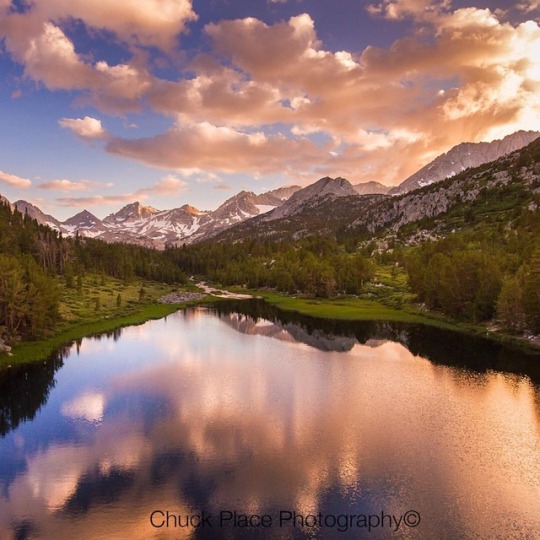
Aerial of Little Lakes Basin on the east side of the Sierra Nevada Mountains, California #birdseyeview #droning #droneoftheday #droneworld #dronepic #chuckplacephotography #lake #littlelakesbasin #sierranevadamountains #webstagram #tranquility #landscape #landscapephotography #landscapephotographer #landscapelovers #mountainscape #mountains #earthpix #earthonlocation #drone #dronephotography #dronephotos #dronestagram #dronephotographer #fromwhereidrone #dji #djiphantom4 #djiglobal #aerial #aerialview #aerialphotography #aerialphotographer #aerialphoto #aerialimaging (at Little Lakes Valley)
#dronepic#drone#dronephotos#aerial#mountainscape#dronephotographer#landscapephotographer#earthonlocation#landscape#aerialphotography#droning#littlelakesbasin#earthpix#aerialimaging#sierranevadamountains#lake#chuckplacephotography#droneworld#fromwhereidrone#tranquility#droneoftheday#aerialview#mountains#djiglobal#landscapelovers#dronephotography#webstagram#djiphantom4#dji#dronestagram
1 note
·
View note
Photo
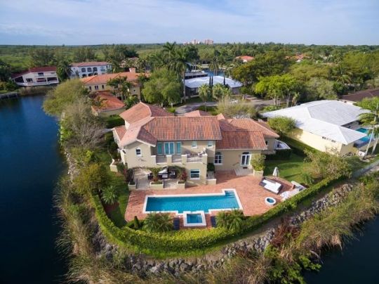
Aerial images and drone technology is changing the way people market their products. An Australian real estate group reported seeing a 403 percent increase in traffic for listings that included video as compared to listings without 💥 . . . Hiring a Drone Pilot for your #RealEstateMarketing is fast, secure and easy with Buzzfli 💥 . . . #buzzfli #drone #commercialdrone #realestate #realestatephotography #aerialimages #aerialphotography #realestateagent #propertymarket #commercialdronepilot #dronepilot #droneoperator #realestateimages #propertyphotography #propertyphotographer #sellinghomes #realestateagents #realestateagency #dronejobs #dronepilotjobs #dronephotography #milliondollarlisting #newlisting https://www.instagram.com/p/Bo73R83AE4g/?utm_source=ig_tumblr_share&igshid=tdx9c7mbcfm4
#realestatemarketing#buzzfli#drone#commercialdrone#realestate#realestatephotography#aerialimages#aerialphotography#realestateagent#propertymarket#commercialdronepilot#dronepilot#droneoperator#realestateimages#propertyphotography#propertyphotographer#sellinghomes#realestateagents#realestateagency#dronejobs#dronepilotjobs#dronephotography#milliondollarlisting#newlisting
3 notes
·
View notes
Photo

A toast to this beautiful view in champagne 🥂 🇫🇷 #dronestagram #aerialimager #france #champagne #vinyard #village #photooftheday #francephotography #francephotolovers #daytrip (at Champagne, France) https://www.instagram.com/p/CV350LnrRHr/?utm_medium=tumblr
#dronestagram#aerialimager#france#champagne#vinyard#village#photooftheday#francephotography#francephotolovers#daytrip
0 notes
Photo

| Docked 🇰🇼 | 📸 @cshafimon Story 📖: A top view of the boats dock. ▪️ ▪️ exif 🎛️ : 📷 : @dji_kw DJI FC6310 🔭 : @dji.aab 🕶️ : - 🎞️ : 200 ⏳ : 1/25 👁️🗨️ : f/2.8 🪜 : @djiglobal phantom4pro . ************************ ************************ #djiphantom4pro #djidrone #phantompilots #djikuwait #djiphantom ............................... @nikonasia @nikonindiaofficial @nikonasia @natgeo @natgeowild @bbcearth @natgeoindia @natgeoyourshot @natgeotravellerindia @natgeo @discovery @bbcearth @frame @varietymedia_ @photo_hub__ @discoverychannelin @official_photographers_hub @moodyframes_ @graffiti_block_official @asprins.of.insta @kuwait.towers @kuwaitgraff @longexposure_shots . . . . . #kuwaittowers #kuwaittower #kuwaitabandoned #kuwaitinstagram #kuwaitphoto #kuwaitlandscape #kuwaitnightsky #cshafimon #kuwaitcity #dji #djiphantom4 #phantompilot #aerialimagery #aerialimages (at Kuwait City) https://www.instagram.com/p/CTl1mg6oP9Q/?utm_medium=tumblr
#djiphantom4pro#djidrone#phantompilots#djikuwait#djiphantom#kuwaittowers#kuwaittower#kuwaitabandoned#kuwaitinstagram#kuwaitphoto#kuwaitlandscape#kuwaitnightsky#cshafimon#kuwaitcity#dji#djiphantom4#phantompilot#aerialimagery#aerialimages
0 notes
Photo

Charlotte . . . Credit 👉🏆📸 @mylesperhour_photogweekend . . . Follow 👉 🇺🇸@conexao.america for more photos and movies about United States 🇺🇸 . . . Alliance @america_states @enjoy_la_ @latinbrazil . . . ✈ Mark your photo with tag #conexaoamerica or @conexao.america and we'll post it! . . . . #clt #charlotte #charlottenc #cltnc #cltskyline #discoverclt #charlottesgotalot #cltguide #skyline #sunset #citylife #charlottephotographer #sonyalpha #cltartist #southendclt #uptowncharlotte #uptownclt #mavic3 #dji #aerialimages #mavic #drone (em Charlotte, North Carolina) https://www.instagram.com/p/Cg3rXv3uc_y/?igshid=NGJjMDIxMWI=
#conexaoamerica#clt#charlotte#charlottenc#cltnc#cltskyline#discoverclt#charlottesgotalot#cltguide#skyline#sunset#citylife#charlottephotographer#sonyalpha#cltartist#southendclt#uptowncharlotte#uptownclt#mavic3#dji#aerialimages#mavic#drone
1 note
·
View note
Last Seen Blogs

thatmexisaurusrex
That Mexisaurus Rex!
justthatkylekid
blaaaah


nikidiary
nini

hsingleton12-blog
Untitled