#atlantic basin hurricane season
Text
youtube
Warming seas supercharge existing tropical storms and have caused the Atlantic Basin hurricane season to start earlier and end later.
Rapid intensification has been happening more often than in the previous century.
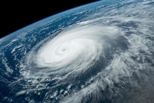
No two storms are exactly alike – that's one factor which makes hurricane observation so interesting. While Hurricane Idalia was powerful, it was also compact. Its relatively modest footprint was good news for Floridians away from its direct path in terms of wind damage.
#tropical cyclones#hurricane idalia#florida#atlantic basin hurricane season#climate change#rapid intensification#warming seas#corene matyas#chad myers#jake tapper
26 notes
·
View notes
Text

"#HurricaneOtis has intensified by 80 mph in the past 12 hours (from 65 mph to 145 mph). That's the fastest 12 hr intensification rate in the eastern North Pacific (to 180°) in the satellite era (since 1966), breaking the old record of 75 mph/12 hr set by Patricia in 2015."
-- #philklotzbach Meteorologist at CSU specializing in Atlantic basin seasonal hurricane forecasts.
#Hurricane Otis#Atlantic Hurricane Season#Pacific Hurricane Season#Rapid Intensification#Hurricane Intensification#Hurricane Satellites
2 notes
·
View notes
Photo
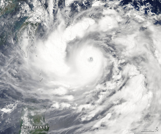
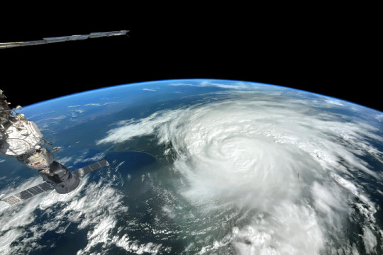
Typhoon Hinnamnor For most of 2022, the world’s ocean basins have been relatively quiet and free of tropical cyclones. This week, Typhoon Hinnamnor shattered the calm, spinning up quickly to category-5 strength in the Western Pacific Ocean. The path of the storm has been erratic and the potential for landfall is currently unclear. The photograph above was taken in the late morning on August 31, 2022, by an astronaut on the International Space Station. On September 1, 2022, the Moderate Resolution Imaging Spectroradiometer (MODIS) on NASA’s Aqua satellite acquired a natural-color image (below) of Hinnamnor. Though the typhoon appeared to be bearing down on Taiwan in the image, it had actually started to turn north and away from the island. Around the time of the MODIS image, the U.S. Joint Typhoon Warning Center reported that Hinnamnor had sustained winds of 115 knots (140 miles/220 kilometers per hour), with gusts up to 140 knots. The storm was approximately 600 kilometers (330 nautical miles) south of Okinawa. By the evening of September 2, winds had slowed to 80 knots (90 miles/150 kilometers per hour), with gusts to 100 knots. The storm had only moved about 50 kilometers (30 miles). On August 30, Hinnamnor became the first category-5 storm on Earth in 2022, as winds reached 260 kilometers (160 miles) per hour. As noted by Yale Climate Connections, it was pretty late in the year for the first storm of such intensity; an average of 5.3 category-5 storms form each year globally. Forecasters are indicating that Hinnamnor might head for South Korea or southern Japan in the first week of September. Sea surface temperatures are several degrees above average, which could help sustain and strengthen the storm in coming days. The Western Pacific typhoon season stretches across the entire year, but the majority of storms usually form between May and October. So far in 2022, 13 tropical storms or depressions have formed in the basin, of which four have become typhoons. In the Atlantic Ocean, the month of August 2022 passed without a single hurricane, the first time that has happened since 1997. NASA Earth Observatory image by Lauren Dauphin, using MODIS data from NASA EOSDIS LANCE and GIBS/Worldview. Astronaut photograph ISS067-E-302073 was acquired on August 31, 2022, with a Nikon D5 digital camera using an 30 millimeter lens and is provided by the ISS Crew Earth Observations Facility and the Earth Science and Remote Sensing Unit, Johnson Space Center. Story by Michael Carlowicz.
8 notes
·
View notes
Text
Updated Hurricane Forecast Still Predicts ‘Above Normal’ Season
https://sciencespies.com/environment/updated-hurricane-forecast-still-predicts-above-normal-season/
Updated Hurricane Forecast Still Predicts ‘Above Normal’ Season
At the start of peak Atlantic hurricane season, conditions in the Atlantic basin continue to indicate that this year’s will be an “above normal” one, federal scientists said Thursday. If those predictions play out, this will be the seventh consecutive year with an above-normal season.
The forecast indicates there could be 14 to 20 named storms, with six to 10 turning into hurricanes that sustain winds of at least 74 miles per hour, said Matthew Rosencrans, lead hurricane forecaster at the National Oceanic and Atmospheric Administration. Three to five of those could become major hurricanes, which have winds of 111 miles per hour or greater, corresponding to Categories 3, 4 and 5 on the Saffir-Simpson scale.
The updated forecast calculates a 60 percent chance of an above-normal season, down slightly from the preseason forecast in May.
The announcement follows a relatively quiet start to hurricane season, with no major storm developing in the Atlantic Ocean. All three of the named storms this year have been “shorties,” or short-lived storms that last less than 48 hours and have minimal impacts.
However, it’s not unusual for storms to ramp up later in the summer, after ocean waters have warmed more and can fuel large, swirling storms. The Atlantic hurricane season officially runs from June 1 to Nov. 30, though it peaks between mid-August and October, when 90 percent of tropical storm activity usually occurs.
Thursday’s forecast was in part informed by a climatic pattern called La Niña, which has been in place intermittently since 2020 and impacts various aspects of weather, including prolonging the drought in the Western United States. La Niña conditions can “enhance Atlantic hurricane activity,” Mr. Rosencrans said, in part because of changes in wind direction and speed.
Scientists have documented a number of ways that climate change is altering cyclonic storms, making them more powerful and more destructive. Hurricanes are unleashing higher amounts of rainfall, which can worsen flooding. And because warmer water fuels hurricanes, the zone in which these storms can form is also expanding out of the tropics and toward subtropics and the middle latitudes.
“It only takes one landfalling storm to devastate a community,” Mr. Rosencrans said, referring to when a storm’s eye crosses the shoreline. “Now is the time to know your risks, develop a plan and be prepared for potential tropical storms or hurricanes ahead.”
#Environment
#2022 Science News#8-2022 Science News#acts of science#August 2022 Science News#Earth Environment#earth science#Environment and Nature#everyday items#Nature Science#New#News Science Spies#Our Nature#planetary science#production line#sci_evergreen1#Science#Science Channel#science documentary#Science News#Science Spies#Science Spies News#Space Physics & Nature#Space Science#Environment
2 notes
·
View notes
Note
psst. can you give me some cool weather facts
I love you /p
Let's talk about the weather phenomenon La Niña and El Niño, which are counterparts to each other of oceanic oscillation! La Niña represents the cooling period of the ocean while El Niño represents the warming period. For 2022, we're currently experiencing the cooling period which causes temperatures to rise in the south and cool in the north. Fun fact, during the La Niña period, there's a more active hurricane season due to decreased wind shear in the Atlantic!
Another fact that I think is cool is how the storm naming system in the US works. There's a list of names for each hurricane basin (Atlantic and Pacific) as well as a list of names for winter storms. These names are rotated with different lists every year, so there's repeat names every couple of years. A name is retired if the storm causes catastrophic damage (Examples are Katrina and Sandy). And if the weather service runs out of names? Well, they used to just use the Greek alphabet but that got too confusing so now there's just a list of back up names every year fjshdishdh
And a weather safety tip to end things off! A tornado watch indicates that weather conditions are right for a tornado to form while a tornado warning means that a confirmed tornado has touched down and has been reported or there is radar indicated activity of a tornado.
#w e a t h e r#i love weather#thank you so much like aaaaaaa#i might ramble about cold fronts later if im bored ktjwkdje#ask
2 notes
·
View notes
Text
NOAA issues its most aggressive hurricane season forecast on record | Fox Weather
1 note
·
View note
Text
Hurricane season 2024
Fresh off the presses is the National Hurricane Center‘s forecast for the 2024 hurricane seasion.
NOAA National Weather Service forecasters at the Climate Prediction Center predict above-normal hurricane activity in the Atlantic basin this year. NOAA’s outlook for the 2024 Atlantic hurricane season, which spans from June 1 to November 30, predicts an 85% chance of an above-normal season, a 10%…
View On WordPress
0 notes
Text
3/25/2024 FISH
alright let's kick it off - *fuck these lights suck in this room* oh we have a guest lecturer coming up later this semester *GOD THESE LIGHTS* ugh more exam 1 presentation from the grads. But we do get to talk about the ENSO cool-ocean basin and circulation and how it fits with climate modes... Again I didn't read the paper- I'm so over these papers. The dude is pulling through with a cohesive thought process for the exam 1 presentation. *ha we got the lights fixed thank God* I've also added a spell check program so hopefully my spelling gets a bit better and not so atrocious. *I totally zoned out for 20 minutes I don't know what's happening*
Rings vs Eddies answered from the last class!- rings are an of an eddy. eddies are reserved for the lower amplitude current variations that are found throughout the ocean.
ENSO and Friends; PDO, NAO, and others. understanding Maine ecosystem responses like plankton, benthos, fish stocks, predator prey correlating with atm indices over decades ( this is a major breakthrough! in fish oceanography). Changes in atm circulation were driving changes in the ocean circulation causing major changes in bioprocesses. With this knowledge fish management needed to wrangle with the idea that fish pops were subject to national variations along with fishing effort
El nino - sothethen oscillation (ENSO) - this is a high area of productivity due to upwelling, catch rate is not consistent as some mother warm equatorial water moves sotu and disrupts the upward flow of nuts. normal years only last a few months but every 3-7 years ... *GAH SLIDE CHANGE* initially thought that was due to a decrease in upwelling favorable wind and local to preu and equadorBUT now we know that it is a part of an ocean wide oscillation in the atm called other isolation. *something something* pressure gradient between the high atm pressure in easter quat PAcf and region of low pressure in are of Indonesia. lower than average gradient=el nino. higher than average gradient = la nina. ENSO is typically associated with large changes in the climate of the equatorial region. Under normal conditions (la nina) the upper mixed layer in the western part of the ocean is substantially deeper than in the east. in the western Pacific ( want west Atlantic) the ocean level is higher. ** This figure sucks** ??Walker circulation?? El nino - strength of wind is a driving factor (not as strong) resulting in wind and water temperature patterns set up on the east side?
Walker circulation - SOI - positive: trade winds typically strong across the warm western PACFONC and pick up plenty of moisture..... GOD SLIDE CHANGE
SOI - southern oscillation index - measures the difference in air pressure between Drwin and Thaiti and is calculated daily. the air pressure difference with the long-term normal difference is expressed... kill me :)
ENSO and teleconnections; as enso proceeded from one phase to another the walker circulation varies in intensity and position. the variations cause weather changes in a number of locations. strong correlations between the warm period of ENSO and droughts in Australia, Indonesia, brazil, and Africa. at the same time dry unusually high rainfall occurs along the equator east of 160 degrees of equator and preu. ~ effects in Pacific and northern Hemi. higher than normal pressure western pacific. at higher latitudes a sequence o alternating high pressure and low-pressure anomalies from a curving eastward thus causing mid-latitudes westerlies to be further south .... *I swear to god why are we speed running this lecture* in Atlantic- el nino event generally suppress Atlantic hurricane activity so fewer hurricane than notal from in the Atlantic during Aug to Oct the paea of Atlantic hurricane season. *yeahhh I didn't do that secondary reading of 264 pages fuck that'd rather fight god than read that in a weekend*
ENSO and marine heatwaves - impacts of global climate change are caused by pulse heat stress events associated with El nino. extreme 2015-16 Nino with unabated global warming instigated... *please* basically caused lots of problems google it. coral bleaching off Australia etc. grapple with overall warming and heat waves as overall and not individual things?? enso and broad-scale climate warming
Okay now we talk about the paper that I didn't read but I need participation points so now time to formulate questions
Participation questions - Okay not to sound not great but how do we measure what is caused by ENSO and what is more anthropogenic? where do we look for that fine line between what is natural and what isn't?
What does ENSO have an effect on "the Blob" in the Pacific?
Walker circulation? does that wind cell? "circulate" in between the Hadley cells at the equator? I guess I'm just confused if this is locally found in the equator portion of South America or does it span across the equator... okay that is poorly phrased is it specifically in the Pacific or does it span across oceans? -Just equatorial pacific. yes is a cell but the size varies if is a nina or nino year.
What is the effect of El Nino on the glapagos what is the oceanography mechanism? - warmer atm conditions, less wind mixing, thus less upwelling and less stratification, thus less nutrients, and lower productivity
Something to ponder - climate effect on disease ecology?
0 notes
Text
Hurricane Preparedness – A Comprehensive Guide

Avoid being unprepared for the devastation and mayhem hurricanes cause when they roar through your community. Knowing how to prepare and what to expect during and after a hurricane will help get you quickly on your feet.

New Image Roofing Atlanta assembled this comprehensive guide for hurricane preparedness, damage mitigation, emergency assistance, and recovery.
Hurricane Preparedness
The Atlantic hurricane season runs from June 1 to November 30. The Atlantic basin includes the Atlantic Ocean, the Caribbean Sea, and the Gulf of Mexico. Severe hurricanes may reach as far inland as Tennessee, northern Georgia, and the Carolinas with damaging winds and potential flooding. Being well-prepared for a hurricane is essential for safeguarding your home and family. Consider the following:
Create a Hurricane Preparedness Plan – Develop a comprehensive hurricane preparedness plan that includes evacuation routes, designated shelter locations, and communication strategies for your family. Practice evacuation drills to ensure everyone is familiar with the plan.
Tip: Carry physical/paper maps and printed emergency contact information (mobile device/internet reception may be interrupted for days or weeks).
Build an Emergency Kit (Go Bag) – Assemble an emergency kit containing essential supplies like water, non-perishable food, medications, first aid items, flashlights, batteries, and important documents. Keep the kit in a readily accessible location.
Identification and Important Documents include:
Personal identification (ID, passport, driver’s license)
Emergency contact information
Insurance information
Medical records and prescriptions
Notarized copies of important documents (insurance, birth certificates, marriage certificates, deeds)
Communication Essentials include:

Fully charged cell phone and charger (with adaptor)
Multiple charged device batteries
Portable power bank
Battery-operated or hand-crank radio
Clothing and Personal Items include:
Multiple changes of clothes (including undergarments and socks)
Sturdy shoes or boots
Hat and gloves
Rain poncho or waterproof jacket
Personal hygiene necessities (toothbrush, toothpaste, soap, feminine hygiene products)
Bath and hand towels
Tip: Have enough supplies to sustain your household, including non-perishable food, medication, disinfectants, and pet supplies (in your go bag or car trunk). You may not have access to replenish these supplies for days or weeks following a hurricane.
Secure Your Home – Reinforce your home’s structural integrity by installing hurricane shutters or impact-resistant windows. Trim trees and branches that could pose a threat during high winds. Ensure that doors and windows are securely sealed.

Stay Informed – Monitor weather forecasts and heed evacuation warnings. Stay informed through official channels, weather apps, and emergency broadcasts. Awareness of the storm’s trajectory and intensity is crucial for timely decisions. Consider the following to stay informed:
Download the FEMA app
Sign up for community alerts
Local and cable weather/news channels
Emergency Alert System (EAS) – no sign-up necessary
Wireless Emergency Alert (WEA) – no sign-up necessary
Know your Evacuation Zone – You may have to evacuate quickly due to a hurricane (if you live in an evacuation zone). Know your evacuation routes, practice with your household and pets, and identify where you will stay.
Tip: Follow local emergency manager instructions (they work closely with state, local, tribal, and territorial agencies and partners). They will provide the latest recommendations based on the threat to your community and appropriate safety measures.
Potential Roof and Home Hurricane Damages
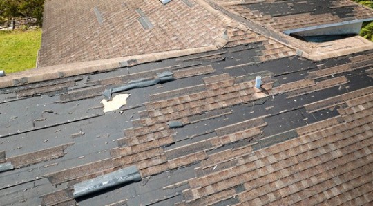
Wind Damage – Hurricane-force winds can cause significant damage to roofs and homes. Inspect your roof for loose or missing shingles, damaged flashing, and signs of uplift. Secure loose items around your property to prevent them from becoming projectiles.
Flooding – Heavy rainfall associated with hurricanes can lead to severe flooding. Inspect your home for water intrusion, especially in basements and lower levels. Address any drainage issues and consider installing a sump pump.
Storm Surge – Coastal areas are particularly susceptible to storm surges, which can result in widespread flooding. If you live in a coastal region, elevate your home on pilings or consider installing flood barriers to mitigate storm surge impacts.
Structural Damage – Hurricanes may cause structural damage to homes, including leaning walls, foundation issues, and compromised support structures. Conduct a thorough inspection after the storm and address any structural concerns promptly.
Post-Hurricane Emergency Services

Check with your local emergency management department, volunteer agencies, or call your local 2-1-1. The FEMA Helpline 800-621-3362 and the American Red Cross 800-733-2767 may be able to provide additional assistance and referrals. Consider seeking the following emergency services:
Evacuation Centers – After a hurricane, local authorities may establish evacuation centers to provide shelter, food, and basic amenities. Follow official instructions and seek refuge in designated evacuation centers if necessary.
Note: If you evacuated, return home only when officials say it is safe.
Medical Assistance – Emergency medical services (EMS) will be available to provide medical assistance after a hurricane. Seek professional medical attention for injuries and health-related issues.
Utility Restoration – Report utility outages, gas leaks, and electrical issues to utility companies. Avoid using damaged utilities until they have been inspected and deemed safe by professionals.
Community Support – Local community organizations and support services may offer assistance, including food distribution, temporary housing, and essential supplies. Stay informed about available resources in your area.
Post-Hurricane Home and Roof Repair
Document Damages – After the hurricane passes, document all damages to your home and roof by taking photographs and narrated videos (multiple images can be extracted from video footage). This documentation will be crucial when filing insurance claims and seeking repairs.
Tip: Take pictures and shoot video footage during fair weather conditions that establish your home’s condition before a severe weather event.
Contact Your Insurance Provider – Notify your insurance company promptly after the hurricane and provide them with a detailed description of the damages along with the documentation you have collected. Initiate the claims process as soon as possible.
Select Reputable Contractors – Choose experienced and reputable contractors for repairs. Obtain multiple quotes, check references, and verify credentials. Ensure the contractors are licensed in your state, insured, and bonded.
Coordinate with Insurance Adjuster – Work closely with your insurance adjuster and contractors during the inspection process. Ensure that all damages are thoroughly assessed and included in the insurance claim.

Timely Repairs – Once the insurance claim is approved, schedule repairs promptly. Address structural issues, roof damage, and any other necessary repairs to restore your home to its pre-hurricane condition.
Due to extensive damages caused by hurricanes, keep numbers/contact information to trusted service providers, including the following:
Roofing Contractor
Tree Service
Fencing Contractor
Flood Mitigation Company
Moving or Pack Out Company
Restoration Contractor
Towing Service
Electrician
HVAC
Plumber
Tip: Avoid using out-of-town or unfamiliar service providers, as many are storm chasers and will not provide or honor service warranties. Instead, seek licensed, bonded, and insured contractors.
Watch this video for more information about your insurance deductible.
youtube
Hurricane Preparedness and Safety
In this article, you discovered essential information about hurricane preparedness, potential damages to roofs and homes, post-hurricane emergency services, and how to repair your home and roof after the storm.
Your awareness and preparedness for hurricane season will minimize potential damages and help you return to normal in the storm’s aftermath.
Lack of proactive measures and delayed action will leave you uninformed and severely challenged to get your home and roof repaired after a hurricane sweeps through your community.
Sources:
nhc.noaa.gov
ready.gov/hurricanes
weather.gov/safety/hurricane-plan
usace.army.mil/Missions/Emergency-Operations/Hurricane-Season
New Image Roofing Atlanta
2020 Howell Mill Rd NW Suite 232
Atlanta, GA30318
(404) 680-0041
To see the original version of this article, visit https://www.newimageroofingatlanta.com/hurricane-preparedness-a-comprehensive-guide/
#Hurricane#Hurricane Damage#Hurricane Preparedness#Hurricane Roof Damage#Emergency Roof Repair#Roof Repair Atlanta Ga#Residential Roofer Atlanta#Youtube
0 notes
Text
Hurricane Storm Panels: Protecting Your Home with Palm Beach Aluminum
It was a typical sunny day in Palm Beach, Florida. The birds were chirping, the palm trees were swaying, and the waves were crashing against the shore. But then, the weather suddenly changed. The sky turned dark and the winds started to pick up. As a resident of Palm Beach, you know what this means - a hurricane is on its way. You rush to secure your home, but you can't help but worry if it will be enough to protect your loved ones and your property. Luckily, there is a solution - hurricane storm panels from Palm Beach Aluminum.

What are Hurricane Storm Panels?
Hurricane storm panels are a type of protective barrier that is installed on windows and doors to protect homes and buildings from the strong winds and flying debris caused by hurricanes. They are made from durable materials such as aluminum, steel, or polycarbonate and are designed to withstand winds of up to 200 miles per hour. These panels are one of the most effective and affordable ways to protect your home during hurricane season.
The Importance of Hurricane Storm Panels
Living in Palm Beach, you are no stranger to the destructive power of hurricanes. These natural disasters can cause widespread damage to homes and businesses, leaving families and communities devastated. According to the National Oceanic and Atmospheric Administration (NOAA), the average number of hurricanes in the Atlantic Basin is 6.4 per year. And as climate change continues to impact our weather patterns, the intensity and frequency of hurricanes are only expected to increase.
As a homeowner, it is your responsibility to protect your loved ones and your property from these powerful storms. And that's where hurricane storm panels come in. These panels act as a shield for your windows and doors, preventing them from breaking and allowing wind and water to enter your home. They are also an essential part of your home's insurance policy, as many insurance companies require homeowners to have some form of hurricane protection in place.
The Benefits of Choosing Palm Beach Aluminum
When it comes to protecting your home from hurricanes, you want to make sure you are choosing the best quality products and services. That's where Palm Beach Aluminum comes in. With over 30 years of experience in the industry, Palm Beach Aluminum is a trusted and reliable source for all your hurricane protection needs.
Here are some of the benefits of choosing Palm Beach Aluminum for your hurricane storm panels:
Expertise: Palm Beach Aluminum has a team of highly skilled professionals who have the knowledge and experience to install hurricane storm panels with precision and efficiency.
High-Quality Materials: Palm Beach Aluminum uses only the best materials for their hurricane storm panels, ensuring maximum protection for your home.
Customizable Options: With Palm Beach Aluminum, you have the option to choose from a variety of styles and colors for your hurricane storm panels, making them not only functional but also aesthetically pleasing.
Fast Turnaround Time: Palm Beach Aluminum understands the urgency of hurricane protection, which is why they offer a fast turnaround time for their services.
Competitive Pricing: Palm Beach Aluminum offers competitive pricing for their hurricane protection services, making it affordable for homeowners to protect their homes.
Palm Beach Aluminum also offers a warranty for their hurricane storm panels, giving you added peace of mind knowing that your home is protected.
Frequently Asked Questions About Hurricane Storm Panels
1. Are hurricane storm panels permanent fixtures?
No, hurricane storm panels are not permanent fixtures. They can be easily removed and stored when not in use. This allows for easy installation and removal when a hurricane is approaching.
2. How long does the installation process take?
The installation process for hurricane storm panels typically takes a few hours, depending on the size and number of panels needed. The experts at Palm Beach Aluminum will work efficiently to ensure your home is protected in a timely manner.
Contact Palm Beach Aluminum for Your Hurricane Storm Panel Needs
Don't wait until a hurricane is on its way to protect your home. Contact Palm Beach Aluminum today for a free consultation and estimate. With their expertise and high-quality products, you can rest easy knowing your home is prepared for whatever Mother Nature throws its way.
Contact Palm Beach Aluminum at (561) 621-1427 or visit their website at https://palmbeachaluminum.com/contact/ for more information.
0 notes
Text
June 1st marks the official start of the Atlantic basin hurricane season. Though there is now a pre-season which starts on May 15th.
It's predicted to be near average this year. Though what is considered average has been creeping up in recent decades.
CNN tracked two hurricane season outlooks this year: the forecast from the National Oceanic and Atmospheric Administration, which was released last week, and another from researchers at Colorado State University, who have been issuing seasonal forecasts for more than 37 years.
NOAA officials are predicting an average hurricane season, with 12 to 17 named tropical storms, five to nine of which could become hurricanes. They expect as many of four of those could strengthen into major hurricanes – category 3 or stronger.
A slightly more optimistic prediction from tropical cyclone Dr. research scientist Dr. Philip J. Klotzbach.
Phil Klotzbach, a research scientist at Colorado State, said in April his group was predicting a slightly below-average season this year: 13 named storms, six hurricanes and two major hurricanes.
The key difference between tropical depressions, tropical storms and hurricanes lies in their wind speeds and the level of organization within the system.
While a tropical depression represents the earliest stage of cyclone development, named tropical storms exhibit more structure and stronger winds. Hurricanes — the most powerful and dangerous of the three — possess the strongest winds and a well-defined eye, making them capable of causing extensive damage over large areas.
According to the National Hurricane Center, there is already a disturbance in the Gulf of Mexico with a 70% chance of tropical cyclone formation in the next two days. Look for updates here.
Even a season which starts off calm can take an abrupt turn.
In 1992 there had been no named storms for the first 11 weeks of the season. Then on August 17th a nondescript tropical wave in the Atlantic became the first named storm of the year. Rapid intensification transformed this storm into Category 5 Hurricane Andrew. It cut through the south of Florida like a buzz saw and had a second act as it stormed through the Gulf and made a second landfall in Louisiana.
Hurricane Andrew
Andrew's style of rapid intensification has become more common in the 21st century.
This season should not be as bad as 2020 when they ran out of hurricane names and then burned through half of the Greek alphabet.
youtube
Yep, one tropical storm in 2020 even made landfall in Portugal. 🇵🇹
Warm seas give hurricanes more strength and make their formation more likely. The unmistakable warming of the Atlantic is responsible for the spike in major hurricanes this century.
#hurricanes#tropical cyclones#2023 hurricane season#atlantic basin hurricane season#climate change#warming oceans#increase in major hurricanes#hurricane andrew
0 notes
Text
Antonio Velardo shares: 2023 Hurricane Season Ends, Marked by Storms That ‘Really Rapidly Intensified’ by William B. Davis and Judson Jones
By William B. Davis and Judson Jones
There have been a combined 37 named storms this year in the Atlantic and Eastern Pacific basins. A high proportion of those quickly escalated.
Published: December 2, 2023 at 05:03AM
from NYT U.S. https://ift.tt/oyEIwlm
via IFTTT
View On WordPress
0 notes
Text
"People on the Gulf Coast and along the Eastern Seaboard can breathe a little easier. The 2023 Atlantic hurricane season, which began June 1, ends today.
The season was above-normal in terms of activity. There were 20 named storms that formed in the Atlantic basin, starting with "Unnamed Storm" and ending with "Tammy." That's the fourth-highest number in a single year since 1950." @NPR
#NPR#National Public Radio#Hurricane Season#Atlantic Hurricane Season 2023#Weather Forecasts#Tropical Weather Outlook#Tropical Season 2023
0 notes
Text
A Busy Season for Hurricanes
Another hurricane season in the Atlantic and eastern Pacific ocean basins has come to a close, and it was a busy one. During an average season, the two basins see 29 named storms. In 2023, there were 37.
Just a few of these struck land as major hurricanes—Idalia in the Atlantic and Lidia and Otis and in the Pacific. However, of all the storms that roiled these two basins, nearly one third had bouts of “rapid intensification”—meaning wind speeds increased by at least 35 miles (56 kilometers) per hour, over 24 hours.
That in itself is not unusual. But what did attract notice from meteorologists was that a handful of 2023 storms not only cleared the threshold for rapid intensification but soared past it. In the Atlantic, Idalia and Lee both saw winds increase by nearly 58 miles per hour (mph) within a 24-hour period, enough for some storm watchers to classify them as “extreme rapid intensification” events. In the eastern Pacific, Hilary, Jova, Otis, and Lidia did the same. Otis was particularly mighty. Its winds surged by 115 mph within 24 hours, more than any other storm on record in the eastern Pacific aside from Hurricane Patricia in 2015.
Rapidly strengthening storms can cause catastrophic levels of damage if they strengthen right before making landfall. That gives little time for warnings and evacuations, compounding the problem that rapid intensification is typically quite challenging to forecast. Current models accurately forecast rapid intensification only about one third of the time. Forecast errors for storms that undergo rapid intensification are approximately 2 to 3 times larger than for other storms, according to one analysis.
Scientists working with NASA’s TROPICS (Time-Resolved Observations of Precipitation structure and storm Intensity with a Constellation of Smallsats) mission aim to change that. They are collecting and analyzing data from the constellation of five satellites to better understand what triggers certain storms to intensify rapidly. Eventually, they expect data and insights gleaned from TROPICS will be used to fine-tune weather models and improve forecasts of hurricane intensity.
The 2023 hurricane season provided the TROPICS science team with its first chance to analyze TROPICS observations for a full season. They collected data about the structure of all Atlantic and eastern Pacific basin storms, as well as some storms in other parts of the world.
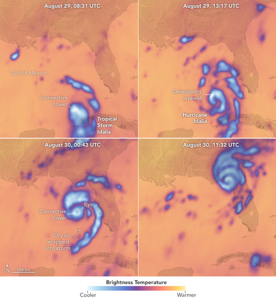
The images at the top of the page highlight TROPICS observations of Idalia—the most damaging hurricane to hit the United States in 2023—as the storm underwent rapid intensification and hit the coast of Florida on August 29 and 30. Each scene shows brightness temperature: that is, the intensity of radiation detectable at a certain frequency moving upward from the top of the storm toward the satellites. Cold brightness temperatures (blue and white) represent radiation that has been scattered by ice particles in the storm clouds, revealing information about the storm’s precipitation. The coolest temperatures are generally associated with the tallest clouds.
“If the infrared satellite imagery of hurricanes you typically see on the news is like looking at a photograph of just the cloud tops, TROPICS images are more like X-rays,” said Patrick Duran, the TROPICS mission applications lead. “Microwave sounders allow us to see below the cloud tops into the inner structure of the storm, where some of the processes most important for intensification occur.”
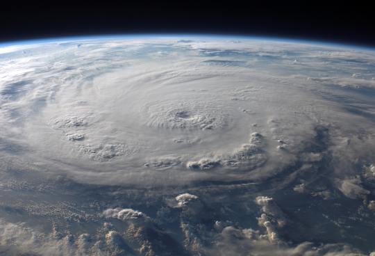
A storm’s structural changes are less apparent in natural-color and infrared images, which primarily show the tops of clouds. The natural-color photograph above, taken from the International Space Station, shows Idalia on August 30, 2023, soon after the storm made landfall.
TROPICS also provides more frequent microwave observations than researchers have had before. Each of the five TROPICS satellites contains a sounder that collects data across 12 channels to detect temperatures, moisture, and precipitation around and within storms. The configuration makes it possible to sample storms about once every hour on average.
“In Idalia’s case, those frequent overpasses allowed for improved tracking of changes in storm precipitation structure and intensity from a highly sheared, disorganized tropical storm to a rapidly intensifying, well-organized hurricane over a period of a day and a half,” said Scott Braun, the NASA TROPICS project scientist at Goddard Space Flight Center. Vertical wind shear, the change in wind speed and direction with altitude, can cause a vertical tilt of the storm circulation and shift precipitation to one side of the storm center. As shear weakens, the storm becomes more upright, precipitation begins to surround the storm center to form an eye, and intensification often ensues, Braun said.
At 8:31 Universal Time (4:31 am local time) on August 29 (top left), winds from the Category 1 storm had reached 75 mph. Five hours later (top right) image, tall columns of thunderstorms—sometimes called convective towers or hot towers—had begun to build an eyewall north of the strengthening storm’s center of circulation. Sixteen hours later (lower left), a clear eye had formed, the rain bands had become more symmetrical, and winds had surged to 110 mph. Idalia hit its peak strength, with 130 mph winds, a few hours later. By 11:32 UTC on August 30 (lower right), the storm was weakening after making landfall in Florida’s Big Bend region.
The cross-track microwave sounders operating on other current satellites observe up to only 190 gigahertz (GHz), but a new channel at 205 GHz allowed TROPICS to make detailed observations of ice particles that yielded new information about storm structure, said William Blackwell, the TROPICS principal investigator and an atmospheric scientist at the Massachusetts Institute of Technology. “That was a real triumph,” he said. “When coupled with the improved revisit rate of TROPICS, this kind of information could yield improved intensity forecasts.”
Intensity forecasts were quite accurate for Idalia largely because aircraft observation of structural features like precipitation were assimilated into forecast models. “Many storms don’t have aircraft reconnaissance, especially storms that are far from land or in other ocean basins,” Braun said. “For these storms, observations of the structure by TROPICS could fill a critical information gap.”
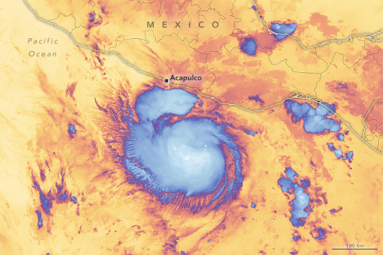
One 2023 forecast that might have benefited from additional data and monitoring in 2023 was for Otis. A day before landfall (shown above with data from the NOAA-20 satellite), most models called for Hurricane Otis to hit western Mexico as a weak tropical storm. Instead, it ballooned into a category 5 monster that battered Acapulco, taking the lives of dozens of people and causing damages that exceeded $2.5 billion.
One of the goals of TROPICS is to improve understanding of the relationship between broader environmental conditions, storm structure, and rapid intensification. Warm sea surface temperatures, excess ocean heat content (a measure of the water temperature below the surface), and low vertical wind shear are the key environmental conditions required for rapid intensification, but only a subset of storms that encounter these favorable conditions undergo rapid intensification.
Many hurricane experts think record-breaking sea surface temperatures likely helped fuel the rapid intensification of several storms in 2023. Hurricane Lee, for instance, surged from a tropical storm to category 5 status in the Central Atlantic between September 6 and September 7.
That rate of intensification surprised many meteorologists, prompting some to call the surge in winds an example of “hyper-intensification.” It made Lee the seventh hurricane in the satellite era to intensify by 80 mph or more in 24 hours. It also put Lee in the top .04 percent of all 24-hour intensity changes in the Atlantic, said Kieran Bhatia, head of climate solutions for the Americas for the reinsurance brokerage Guy Carpenter and the author of a 2022 study that analyzed global trends in rapid intensification.
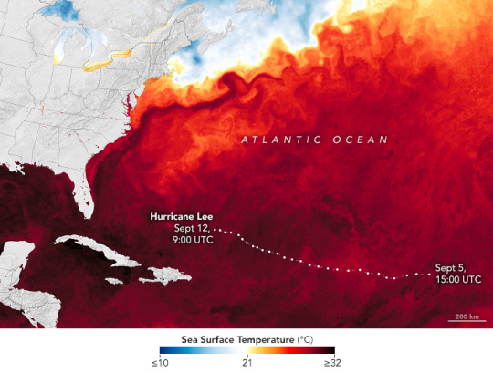
Both Idalia and Lee passed over water with sea surface temperatures that were 4 degrees Fahrenheit (2°C) above average as they were strengthening, suggesting that the extra heat available to the storms likely helped fuel their rapid intensification.
Bhatia and colleagues have documented upward trends in tropical cyclone rapid intensification in several basins in recent decades. They have also presented evidence indicating that the thermodynamic environment—sea surface temperatures and maximum potential intensity—around storms has become more favorable for rapid intensification since 1980, as greenhouse gases accumulated in the atmosphere and the globe warmed.
“We do see signs that climate change may be contributing to an observed increase in the proportion of rapidly intensifying hurricanes on a global scale,” Bhatia said. “But this type of research is still in its infancy. Before we can say there is a direct link between climate change and tropical cyclone intensification trends, we need a new generation of global climate models that can better resolve the finer scale processes of the most intense hurricanes.”
NASA Earth Observatory images by Lauren Dauphin, using data provided by the TROPICS team. Astronaut photograph of Idalia ISS069-E-084870 was acquired on August 30, 2023, with an Apple camera using a focal length of 1 millimeter. Image of Otis by Michala Garrison, using VIIRS data from NASA EOSDIS LANCE, GIBS/Worldview, and the Joint Polar Satellite System (JPSS). Image of sea surface temperatures and Lee by Lauren Dauphin, using GOES 16 imagery courtesy of NOAA and the National Environmental Satellite, Data, and Information Service (NESDIS) and data from the Multiscale Ultrahigh Resolution (MUR) project. Story by Adam Voiland.
0 notes
Text
Events 10.22 (after 1920)
1923 – The royalist Leonardopoulos–Gargalidis coup d'état attempt fails in Greece, discrediting the monarchy and paving the way for the establishment of the Second Hellenic Republic.
1934 – In East Liverpool, Ohio, FBI agents shoot and kill notorious bank robber Pretty Boy Floyd.
1936 – Dod Orsborne, captain of the Girl Pat is convicted of its theft and imprisoned, having caused a media sensation when it went missing.[7]
1941 – World War II: French resistance member Guy Môquet and 29 other hostages are executed by the Germans in retaliation for the death of a German officer.
1943 – World War II: In the second firestorm raid on Germany, the RAF conducts an air raid on the town of Kassel, killing 10,000 and rendering 150,000 homeless.
1946 – Over twenty-two hundred engineers and technicians from eastern Germany are forced to relocate to the Soviet Union, along with their families and equipment.
1947 – The Kashmir conflict between India and Pakistan begins, having started just after the partition of India.
1962 – Cuban Missile Crisis: President Kennedy, after internal counsel from Dwight D. Eisenhower, announces that American reconnaissance planes have discovered Soviet nuclear weapons in Cuba, and that he has ordered a naval "quarantine" of the Communist nation.
1963 – A BAC One-Eleven prototype airliner crashes in UK with the loss of all on board.
1964 – Jean-Paul Sartre is awarded the Nobel Prize in Literature, but turns down the honor.
1964 – An all-party Parliamentary Committee selects the design which will become the new official flag of Canada.
1975 – The Soviet uncrewed space mission Venera 9 lands on Venus.
1976 – Red Dye No. 4 is banned by the US Food and Drug Administration after it is discovered that it causes tumors in the bladders of dogs.
1981 – The United States Federal Labor Relations Authority votes to decertify the Professional Air Traffic Controllers Organization (PATCO) for its strike the previous August.
1983 – Two correctional officers are killed by inmates at the United States Penitentiary in Marion, Illinois. The incident inspires the Supermax model of prisons.
1987 – John Adams' opera Nixon in China premiered.
1997 – Danish fugitive Steen Christensen kills two police officers, Chief Constable Eero Holsti and Senior Constable Antero Palo, in Ullanlinna, Helsinki, Finland during his prison escape.
1999 – Maurice Papon, an official in the Vichy government during World War II, is jailed for crimes against humanity.
2005 – Tropical Storm Alpha forms in the Atlantic Basin, making the 2005 Atlantic hurricane season the most active Atlantic hurricane season until surpassed by the 2020 season.
2005 – Bellview Airlines Flight 210 crashes in Nigeria, killing all 117 people on board.
2006 – A Panama Canal expansion proposal is approved by 77.8% of voters in a national referendum.
2007 – A raid on Anuradhapura Air Force Base is carried out by 21 Tamil Tiger commandos, with all except one dying in this attack. Eight Sri Lanka Air Force planes are destroyed and ten damaged.
2008 – India launches its first uncrewed lunar mission Chandrayaan-1.
2012 – Cyclist Lance Armstrong is formally stripped of his seven Tour de France titles after being charged for doping.
2013 – The Australian Capital Territory becomes the first Australian jurisdiction to legalize same-sex marriage with the Marriage Equality (Same Sex) Act 2013.
2014 – Michael Zehaf-Bibeau attacks the Parliament of Canada, killing a soldier and injuring three other people.
2019 – Same-sex marriage is legalised, and abortion is decriminalised in Northern Ireland as a result of the Northern Ireland Assembly not being restored.
0 notes
Text
With Rare Atlantic Nino, Atlantic Basin Hurricane Outlook Intensifies
A New York City-based business executive, Roger Coleman delivers client-centered solutions that range from emergency preparedness to disaster prevention. Among Roger Coleman’s areas of expertise in NYC and beyond is helping communities map risks associated with hurricane season and preparing for worst case scenarios, should disaster strike.
The need for comprehensive hurricane mitigation strategies has never been more pressing, with Colorado State University (CSU) researchers in mid-2023 updating their Atlantic Basic forecast for the remainder of the year to “borderline hyperactive.” The backdrop was one in which three tropical storms had already been recorded by July 8th, nearly a month before that tally is typically notched. This caused the researchers to revise their forecast upward from 13 to 18 named hurricanes (the National Oceanic and Atmospheric Administration prediction of 12 to 17 remained unchanged).
One aspect of this increased activity is a rare Atlantic Nino (Dakar Nino) event that is warming waters in the Atlantic Ocean to a temperature well above normal. This makes the entire basin more vulnerable to tropical weather pattern development. At the same time, CSU researchers now discount the degree to which the heated water’s effects will be offset by wind shear reduction. The CSU team further projected that four hurricanes will be major ones expected to sustain winds in excess of 111 miles per hour.
0 notes
Last Seen Blogs


turkfill
Untitled

farnoush-farsiar7lddaa11
My Farnoush Farsiar brilliant blog 1702

mr-mode
Mr Mode

hometoursandotherstuff
Home Tours & Other Stuff