
franklloydalwaysright
Frank Lloyd Always Right
Group of University of Cincinnati students writing blogs about Urban Planning. Background photo taken by farlukar
9 posts
Don't wanna be here? Send us removal request.
Last Seen Blogs

lowbrowacademic
existence in dark fragments

invisible-pink-toast
Invisible-Pink-Toast

frut-lups
Messy Main Blog

moonpeachmoth
Quantumplated

nickelsonwooster
NICK WOOSTER
Text
Elements of Future housing construction in Cincinnati
Cincinnati, being as old of a city as it is, consists of many different types of housing stock ranging in style and form. The city has seen several centuries of demographic transition and the built environment reflects this. When looking at modern day Cincinnati, many of the development that occurs in the city reflects that of development in many large cities across the country, however, there exist elements of modern housing construction that can set Cincinnati apart from other American cities and provide cheap, effective, and quality housing.
Adaptive Reuse
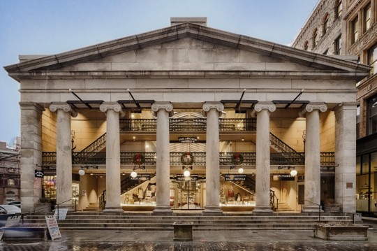
Adaptive reuse is the act of converting an older building into a new space that serves a different purpose from its original, intended one. This is common across cities to see old, industrial neighborhoods become gentrified as this method of creating housing often comes with a certain audience of residents set in mind. When looking at adaptive reuse in Cincinnati, there exist many examples of centuries old structures seeing upgrades and becoming housing. An example we want to focus on for adaptive reuse is the conversion of St. Francis Hospital, built in 1889 in the Fairmount Neighborhood, into St. Francis Court Apartments. Designed by George W. Rapp and Built in Queen Anne style, the ornate brick building served patients up until 1981, when the hospital closed and relocated to Westwood. The building was added to the National Register of Historic Places in 1984 and since then has been converted into apartments and senior living units. The existing buildings boast 161 units over 4 stories and feature a variety of amenities for residents.
When looking at adaptive reuse at a surface level, preservation of historic buildings seems like a no-brainer for any city. However, this method of housing construction only works in the context of appreciation for history in a city, rather than a need for more housing. Adaptive reuse does more for preservation of a structure rather than meeting demands for new housing units. This means that quality of living is often sacrificed for historical preservation, however this does not take away from the importance of adaptive reuse as it acts as an important tool for preserving the historical legacy of our cities.
An example of adaptive reuse outside Cincinnati would be The Arcade Providence. Following the theme of repurposing historic buildings to keep them alive, this historic mall located in Rhode Island was converted into an inexpensive mixed-use apartment complex, with 48 units of small lofts replacing the mall's upper areas, while the lower floor has kept its historic commercial design. Across the US, cities have been witnessing a trend of abandonment of shopping malls, Cincinnati's own Forest Fair Mall is a part of this shift and could take inspiration from this style of reuse.

St Francis Hospital, Fairmount Cincinnati
https://westsidehistory.wordpress.com/2016/06/06/st-francis-hospital/#jp-carousel-1137
"Westminster Arcade - 1828" by Timothy Burling is licensed under CC BY 2.0.
Prefabricated Construction
Prefabricated housing is a method of housing construction where elements such as facades, supports, structures, or buildings are built off site and transported to the development site. Prefabrication, or prefab, is often used to speed final construction times and reduce overall construction costs, as building off site allows for mass production of elements. While prefab is often attributed to modular and trailer homes, any part of a building can be built offsite and assembled at the development site.
An example here in Cincinnati is the renovation of Calhoun Residence Hall on the University of Cincinnati’s campus. Designed by Potter, Tyler, Martin, and Roth and built in Modern International Style in 1967, Calhoun Hall has seen no renovations since its construction and became a very outdated dormitory in our modern age. In 2022, the University of Cincinnati began renovations to Calhoun Hall and its identical building Siddall. In contrast to other dorm renovations on campus, Calhoun featured prefab facades as the main component of its new version. Each floor received several panels and were installed on the side of the existing support. This sped up construction times and reduced costs, and these panels did not have to be created on site and only required installation.
The Modular Timber apartment blocks in Ridderkerk, Netherlands, are another prime example of quality prefabbed housing. The design uses prefabricated wooden modules and pieces of the previous building on the lot to create a more sustainable and affordable development. Given Cincinnati’s housing crisis and lack of affordable homes, this style of building could be implemented as a fast and inexpensive solution to the issue.
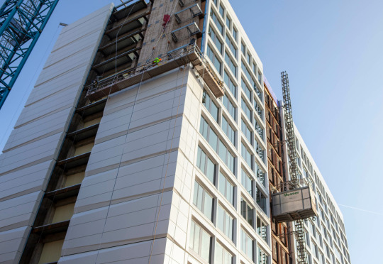
Calhoun Residence Hall, Cincinnati OH
https://www.messer.com/project/university-of-cincinnati-calhoun-hall-renovation/
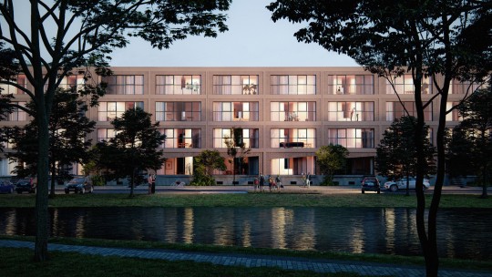
Modular Lumber housing blocks in Ridderkerk, Netherlands
https://www.archdaily.com/986186/ha-ha-designs-modular-timber-system-to-create-affordable-housing-in-rotterdam
Sources:
https://westsidehistory.wordpress.com/2016/06/06/st-francis-hospital/
https://npgallery.nps.gov/AssetDetail/NRIS/84003714
https://www.apartments.com/st-francis-court-apartments-cincinnati-oh/mhrvd9h/
https://www.boredpanda.com/americas-oldest-shopping-mall-micro-lofts-arcade-providence-northeast-collaborative-architects/
https://www.messer.com/project/university-of-cincinnati-calhoun-hall-renovation/
https://www.uc.edu/news/articles/2022/05/uc-calhoun-hall-residence-tower-rises-in-high-style.html
0 notes
Text
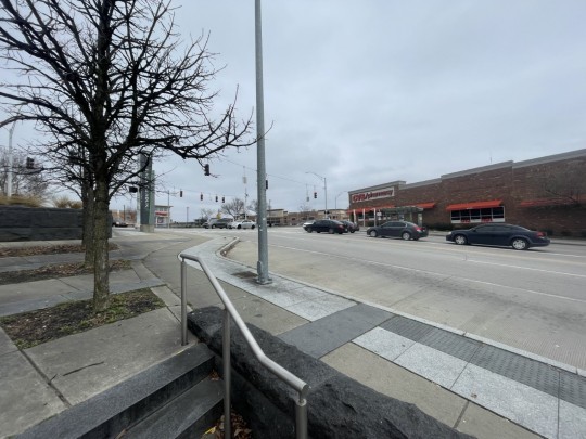
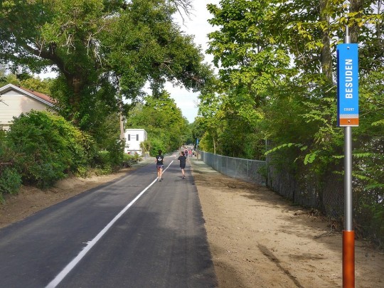
Future BRT Stops in Cincinatti
Bad Urbanism - Behind the bus stop there is an entirely empty city block, increasing the distance between the stop and any destinations. However, the site was recently bought out by the University of Cincinnati to build more student housing, so this will likely change in the future.

Good Urbanism – Across the street from the BRT stop is a local park, allowing riders to easily access green space within a minute's walk. The stop is also quite close to the Crossroads church, the Mainstreet of Calhoun, and the University of Cincinnati, all major destinations within a 5-minute walk from the stop.
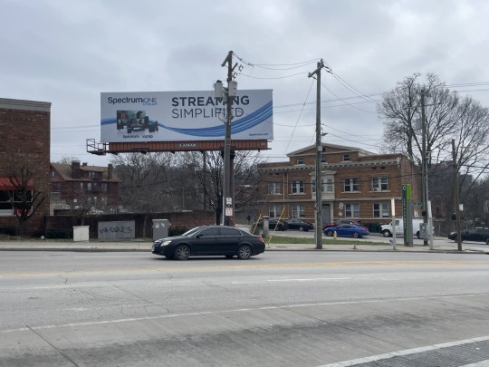
Bad Urbanism - Many of the Lots around the BRT stop have been demolished in the past decade, leading to a steep decline in the density of housing and businesses around the stop. Also, the BRT stop is surrounded by 3 major roads with large amounts of high-speed traffic, creating a safety issue.
Good & Bad Urbanism – The Bus stop is directly across the street from a CVS pharmacy and within a 2-minute walk to a Walgreens and Kroger Grocery store. While its proximity to these necessary amenities is considered good urbanism, to reach these businesses you must cross up to 2 major roads and a large parking lot, which presents several safety issues. On top of this, none of the major businesses are local businesses.

Good Urbanism – The infrastructure around the BRT stop is quite good. The BRT stop has a well-lit seating area allowing riders to sit in a dry area when waiting for the bus, and the sidewalks around the stop are smooth, making it more accessible. The only immediate downside to the stop is the steep hill it's situated on, which can create a challenge for some riders.
Summary of a historical background of the neighborhood
The Vine-McMillan-Calhoun BRT stop is cleverly focused on the intersection of the Mt. Auburn, CUF, and Coryville neighborhoods. Post Civil War, CUF remained empty, undeveloped land. Beginning in the late nineteenth century, residential developments surged with the main reason being the newly opened Bellevue and Fairview inclines were completed. Educational and institutional developments weren’t too long after. The beginning half of the twentieth century led to a significant increase in single-family homes, while the second half was more geared towards families moving from the city to the suburbs. During this time, the University of Cincinnati began major expansions and medical centers nearby.
First organized by Dr. Otto Juettner pre-1910, the Clifton Heights Welfare Association was created. Started as a civil body that promoted fraternal, social, municipal, and community welfare, to this day, it remains one of the oldest neighborhood councils in the city. Being renamed as the Clifton Heights, University Heights, Fairview Neighborhood Association (CUF), adopted in 1987, this organization concerns itself with zoning regulations, to traffic patterns, human needs, and even attractive appearance.
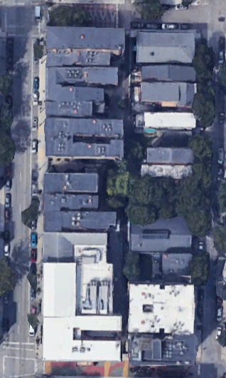
An asset map of the neighborhood within 1/4mile from BRT stops showing amenities (coffee shops, restaurants, grocery stores, parks, transit lines/stops, etc.) – You should create your map using GIS or other software.
Map:

Discussion Question: What do you think this area could benefit from having in terms of the BRT
1 note
·
View note
Text
What are the barriers to TOD in America, and how can cities overcome this issue?
What are TODs?
Transit Oriented Developments are developments designed to maximize the efficiency of transit stops by increasing the density and attractions within a walkable radius of transit. These developments often feature a transit stop (train, tram, bus, etc.) surrounded by a ¼ to ½ mile circle of dense (often mixed use) commercial, places of employment, and public spaces. Outside of the inner circle, there is also an outer circle of increasingly less dense residential as you move further away from the stop.
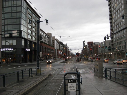
"Transit-Oriented Development at 4th and King Caltrain Station - Mission Bay San Francisco" by neighborhoods.org is licensed under CC BY-SA 2.0.
Barriers
One of the most common barriers for implementing TOD in American cities is the high presence of NIMBY (Not in My Backyard) residents that protest these types of developments. NIMBY’s are often residents that have deeper involvement in the community and shoot down proposals that would bring more housing to their neighborhood. This is the case for many Transit Oriented Developments, as these projects often bring dense, larger scale housing to neighborhoods. In the case of NIMBY’s, the most common form of pushback is that the large scale of development will ruin the “character” of the neighborhood. In many cases, NIMBY’s have lots of pull in terms of influencing city council members and have the power to drastically alter or cancel TOD projects all together.
However, NIMBYs are only half of the issue when getting TOD projects completed, often car-oriented infrastructure, and the design of US cities poses a massive barrier to TOD projects. The main component of TOD is the transit itself, which it often runs on its own right of way separate from cars. However, cars still too often play a part in terms of TOD projects and can reduce the efficiency of the transit line/housing built. The most obvious impedance is that the majority of residential developments built still must adhere to car-oriented housing and zoning codes. Car centric suburbs continue to be the most prominent and mass-produced style of housing. This lack of density severely limits the effectiveness of public transit, gutting the walkability and bikeability of these neighborhoods and limiting the access to transit stops.

"An American suburb" by futureatlas.com is licensed under CC BY 2.0.
Solutions
While many of these barriers provide significant challenges for Transit Oriented Developments in the United States, there are ways to successfully get around them, the first being zoning higher density around transit stops. High-density developments around the central transit stop are one of the defining aspects of a successful TOD and are key to making them more accessible to residents in the area. The more people you have living, working, and shopping within walking or biking distance from the stop, means the more people can use it with relative ease. On top of this, using a street layout more conducive to walkability would also decrease the barriers to creating a successful transit-oriented development. By getting rid of the pedestrian-limiting cul-de-sacs in favor of a street network that provides multiple routes & intersections to the transit stop (the gridiron is a good example), we can create a more accessible and efficient TOD area.
Finally, while working around the NIMBYS is an option in some cases (often with consequences later down the line). These kinds of conflicts are best resolved by working with the community to dispel misconceptions and create a mutually beneficial outcome. By recognizing the community's concerns and creating policies and amenities to meet them (like working to limit gentrification, a common concern), you can often reach a much stronger and more effective resolution to this barrier.
Example
A great example of usage of TOD can be found around the subway stations in Paris, France. Built in 1900, the subway provides access to 1.5-2 million jobs by mass rapid public transit within 30 minutes. Paris distributes it’s subway stations in concentric successive circles with the most density accommodated in the first 5-kilometer radius circle. Job densities show a similar density within the first 3 kilometers of the radius and then decline with distance. The stations are also often located near various indoor malls, shopping centers, and tourist attractions which allow for easy access to more than just places of employment. By building the subways in a manner that allows access to so many jobs and other things in France, as well as having the train run so frequently, the Paris subway stations are without a doubt a great example of transit-oriented development.

"Paris Subway Sign" by sri_the_quack is licensed under CC BY-SA 2.0.
1 note
·
View note
Text
What are possible ways of alleviating food insecurity in Cincinnati (including the UC campus)?
Eliminate Food Deserts
Many neighborhoods in Cincinnati do not contain any grocery stores. Neighborhoods such as Bond Hill, North Avondale, and Oakley all do not contain supermarkets and require over a 1 mile walk to reach one. This lack of supermarkets requires people to not only pay for transportation to and from a grocery store, but then also to pay for the groceries. Our group thought of two ways to solve this problem. To build more transportation routes to grocery stores from any neighborhoods that do not have any immediate access to one. Our other solution is to simply build more grocery stores in Cincinnati. The latter one being objectively more difficult to but does provide a better solution for everyone. By simply building a bus route people still have to pay for transportation to and from the grocery store but it is much cheaper than using a rideshare app. But by building grocery stores in food deserts, they would get guaranteed business as everyone needs food to survive and when looking for places to go food shopping, most people are going to choose the place that is most convenient for them to shop at, especially if they do not have any form of transportation.

"grocery store in london" by stefo is licensed under CC BY 2.0.
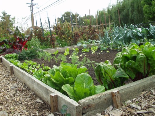
Community resources (gardens, kitchens, pantries, farmers markets)
Community gardens are a great way to produce quality and healthy ingredients for meals. Growing crops in urban areas is also a great way to create jobs and create more of a sense of community within and around the gardens area. Just adding greenery as well is a great way to add to the atmosphere of any space. Community Kitchens also are great way to provide meals that can be nutritious with the right ingredients. These kitchens are also a great way to bring the community together by providing an area for people to gather and enjoy food together. Community kitchens can also aid to teach cooking skills to the youth of the community, effectively alleviating food insecurities in two ways. Food pantrys are also great places to provide ingredients to entire communities as well. Here at UC, just off campus you can find the bearcat pantry which provides all UC students with many different groceries all free of charge. All three of these resources listed are both great ways to provide jobs to people in Cincinnati but also ways to alleviate food insecurity as well.
"Beresford Community Garden, San Mateo" by vicki moore is licensed under CC BY 2.0.
Food stamps and other programs
Cincinnati can provide more funding and raise the maximum income requirement to access food stamps and assistance. Almost 30% of families cannot afford food based on their given income (Living in poverty in Cincinnati - Heatheirare Access Now). Given the inflation and the rapid increase of food prices in the past decade, raising the maximum income cap for food assistance would allow people who face food insecurity eligible to receive assistance. This could be provided by expanding outreach to poorer neighborhoods and more flexible eligibility criteria that target those excluded from food stamps. Specially targeting the food insecurity of UC, UC should offer less expensive meal plans for students facing food insecurity. Meal plans at the University of Cincinnati start at 2,528, with no inexpensive options available. Schools such as UC should be providing free, QUALITY lunches and breakfasts for all students. More options such as Bearcat Pantry should be available to students and poorer neighborhoods in Cincinnati.
Discussion Question – Why do you think that despite food insecurity being such a big issue in Ohio, there isn't much action being taken against it?
0 notes
Text
What types of regional and local transport does Cincinnati need more in the future?
Cincinnati is currently lacking in public transportation and needs to expand its service. As it stands, the city only utilizes 2 modes of transportation, buses and the streetcar. While the bus network reaches into most neighborhoods and provides good baseline service, many routes cannot sustain current capacity and are ripe for expansion. This is why we believe a comprehensive Regional Rail, High Speed Rail, and bike service network should be prioritized for Cincinnati and the surrounding metro area. The Cincinnati combined metro area has a population of 2.2 million, and currently has no other methods of transportation outside of personal vehicles. Cincinnati also suffers from large amounts of traffic congestion, however no other options for travel exist. Providing useful public transportation would not only decrease traffic, but lower carbon emissions in the area.
High Speed Rail
The biggest form of public transportation that Cincinnati is not currently utilizing is a high-speed railway. By building a railway that connects even to just the major cities in Ohio, it would allow many people access to statewide travel. Railways have also proven to be generally safer than car travel as well as producing less carbon emissions. Currently, there only exists one intercity line between Cincinnati, Chicago and New York City that runs 3 times a week. The current Amtrak route is slow, plagued by delays, and is not efficient in connecting Cincinnati to other cities. With a high-speed rail network, Cincinnati could become connected with other large cities in the Midwest, with extremely useful corridors such as the Cleveland, Columbus, Dayton, and Cincinnati alignment. Railways are also a great source of revenue for the state. By using tax-payers money to build the railways, they would be more affordable for Cincinnati to build.

"CONNOLLY TRAIN STATION-1008" by infomatique is licensed under CC BY-SA 2.0.
High Speed Rail
Reliant on there being a national high speed rail network, but would be super cool
Bike network
The smallest and most versatile form of transport would be bikes. This is something that Cincinnati has already been exploring with Cincy RedBike, a bike-share network that just reported its highest ridership yet in 2023, with 140,000 rides. On top of this, Cincinnati already has existing bike routes, such as the popular Wasson Way, a 6-mile-long greenway through eastern Cincy. The approval of these programs shows the value of having such a system in place. We propose a combination of expanding Cincinnati Redbike, expanding greenways, and building separated bike paths through the city. This will make biking both more accessible and safer to use and decrease the carbon emissions generated by smaller trips.
"Wasson Way" by 5chw4r7z is licensed under CC BY-SA 2.0. Streetcar Network
Trams are less expensive than busses
can carry more people
easily electrified
If the regional train system is the large transportation network, trams can be the smaller, more local transport system
Regional Rail
Often overlooked in the conversation of public transportation, regional rail networks often provide some of the most key services in urban metro areas. Regional rail services allow easy access from outer cities and suburbs to the inner city. While these trains do not run as frequently as a metro service, they offer higher capacity and can substitute many singular car commutes downtown. Downtown Cincinnati is still very oriented towards suburban commuters, as many of the streets act as one-way arterials and many lots are comprised of parking garages. A regional rail system would greatly benefit Downtown Cincinnati as suburban commuters will be able to take the train downtown and replace car trips on the interstate. In turn, Downtown would see less congestion and improvements in pedestrian infrastructure.
Expanded Streetcar Network
Finally, an expanded streetcar network would be beneficial to the city of Cincinnati. While it is a good move for the city to chase BRT (Bus Rapid Transit) routes in context of the current day city, using the ROW (Right of Way) for streetcars instead would provide higher capacity transportation. Streetcars are street-running trams that act similarly to a metro, with dedicated stops along the route. Streetcars, while often operating in mixed traffic, need their own dedicated ROW in order to properly function. A streetcar system would not act on their own, as bus connections are important for them to work. This mode of transportation would replace many low distance trips along busy corridors that would normally be taken by car.

"Rotterdam Tram" by Michel Curi is licensed under CC BY 2.0.
Regional Train System
Services the tri-state area, connecting the outer neighborhoods to the main city
Fast, efficient
Conclusion: Overall, Cincinnati has done a pretty good job at providing local public transportation, but there are areas that they can expand upon in terms of longer distance public transportation. By adding more railways, people in Cincinnati would be able to go more places from this one city while simultaneously cutting down on their carbon emissions.
Discussion Question: Out of all of the public transportation options given, which one would you work towards implementing first?
0 notes
Text
What’s the “best” density for the design of cities today?
It is difficult to find a “perfect” block size and density in American cities, however, there still exists many good examples of urban fabric. When combining all the factors that make urban living viable, we come to the consensus that an ideal population density is around 35 Units per acre (16,000 people per square mile, 161.7 Ppl/Mi^2). In Cincinnati, there exists historic sections of the city that support this population density such as the neighborhood of Over the Rhine (OTR). When looking at OTR, we find that many blocks meet our criteria for good density for our cities today.
Our Block:
Our group chose the block between Race St., Republic St., & W. 14th, in northern section of Over the Rhine. What makes this block of Cincinnati such a desirable example is the pleasant streetscape that allows nearby buildings to thrive. This sort of density rarely exists in American cities, so this remaining block of legacy housing stock has become incredibly valuable. Let's look at the qualities of this block that represent our ideal city density.
"Race Street" by Travis Estell is licensed under CC BY-NC-SA 2.0.
Density:
Our block is almost entirely comprised of 3-4 story European style rowhomes, with a FAR of 2.7 and 36 Units per Acre. This density gives the streetscape a sense of scale without crowding the sky or overwhelming its residents. The buildings host a mix of uses, with commercial on the street level and offices and residential units above. This contributes to the community's overall walkability, with jobs, housing, and shops all within a good distance of each other, this also makes it easier for public transit to operate efficiently. The commercial also brings more people to the area, bringing life and safety to the block by increasing the eyes on the street.
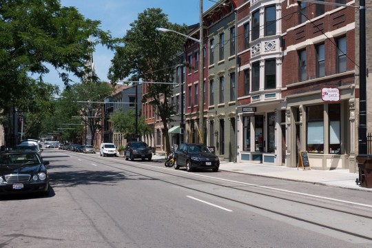
"Race Street" by Travis Estell is licensed under CC BY-NC-SA 2.0.
Transit:
The Connector, Cincinnati’s tram network runs adjacent to our block (up Race St) benefiting the travel flow through the neighborhood. The tram reduces carbon emissions, makes travel more accessible for citizens, and reduces noise levels. The tram reduces road space comparable to other vehicles and the number of cars on the road by providing a reliable mode of travel, benefiting the density of the city.

"Race Street, Over-the-Rhine, Cincinnati, OH" by w_lemay is marked with CC0 1.0.
Plazas and Greenery:
Foot traffic is a very integral part of our block. Tree lined streets flow into public parks and plazas, granting access into the blocks interior and creating spaces people want to use. These pleasant additions promote foot traffic in the area, which cuts down carbon emissions from vehicles as well as reduces traffic in the city. The block's proximity to a major park (Washington Park) & its interior plaza gives residents easy access to open areas for public events and provides a sense of community. The clean alleyway leading through the block's interior and the pedestrianized street make our block more porous and overall, more walkable.

Overall, our block combines elements such as greenery, transit access, mixed use developments, a dense street network, and the regulation of cars to create a good, porous block near the heart of Cincinnati. These amenities work best in denser environments, which is what makes Over the Rhine such a desirable neighborhood.
Class Question: Is density the most important aspect of your ideal city, do you find any other elements to be more important?
0 notes
Text
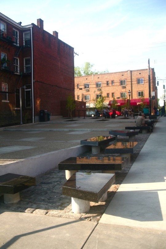
Find a public plaza (square) in your neighborhood or Cincinnati that meets Whyte's Criteria of human scale. Explain its elements and show photos.
Located in the Clifton neighborhood of Cincinnati, Clifton Plaza is a public space that meets the majority of William Whyte’s criteria for an effective public space. The Plaza is located on the south end of Ludlow Avenue and sits between a barber and a coffee shop. With its appropriate location along a busy, walkable street, Clifton Plaza acts as a gathering space for the surrounding neighborhood. Let’s look at what makes this space so attractive for residents.
Seating
Arguably the most important aspect of any public space, Clifton Plaza offers benches, tables, and curbs for people to use. While only several of the seating arraignments being moveable, the variety and availability of seating means that the space is accessible to everyone. The seating is situated so that pedestrian traffic is not impeded, and people can flow through the park freely without being blocked by benches.
"Clifton Plaza" by Travis Estell is licensed under CC BY-NC-SA 2.0.
Relation to the street
Clifton Plaza offers direct access to Ludlow Avenue, creating an oasis along a dense streetscape. Being wedged between 2 buildings creates a sense of retreat along a busy corridor. This is a shared feature of most urban plazas; however, the enclosed space creates a more comfortable environment for users and invites people to use the area. This break in the grid also provides a cut through to a nearby parking lot, encouraging movement through the park.

"Clifton Plaza" by Travis Estell is licensed under CC BY-NC-SA 2.0.
Features
The plaza features several other aspects of Whyte's criteria, which attract many of the residents to frequent the park. It hosts community events that often bring people from both within and outside the neighborhood, on top of this it also offers a cut through to a nearby parking lot and the surrounding neighborhood (triangulation). The accessibility and popularity of the location has led to food trucks often setting up shop in or near the plaza (food attracts people). Additionally, the plaza contains several trees, which add some welcoming greenery to the dense brick landscape of Clifton’s Mainstreet.

"Clifton Plaza" by Travis Estell is licensed under CC BY-NC-SA 2.0.
4. Failures
While Clifton Plaza utilizes many of Whyte’s criteria effectively, which has allowed it to create a popular and pleasant space, it also falls short on others, namely its lack of flowing water and limited sunlight. While the plaza receives some amount of sunlight most days, being north-south facing, its enclosure from the surrounding buildings can also result in little sunlight, making it less appealing in the winter. The plaza also lacks any water features, leaving little to distract visitors from the noises of the nearby street.
If you could add an 8th point to Whyte's criteria, what would it be?
0 notes
Text
City Beautiful: Lessons Learned from Paris and Chicago
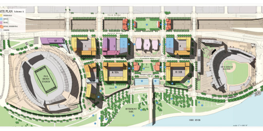
Located alongside the Ohio River, The Banks is the oldest neighborhood found in downtown Cincinnati. Originally the epicenter of freight rail for the western portion of the United States, The Banks have always been central to Cincinnati's identity and image. Only recently has it been renovated due to the Ohio River flooding in 1997. After this tragedy that left all buildings in The Banks unusable, the movement to completely refresh this area of Cincinnati was finally put to work.
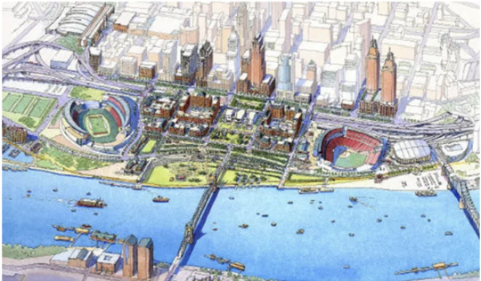
Pictured above is the original draft for The Banks presented in 1997. If you are familiar with The Banks you will notice that the original draft presented is almost identical to how we see this area today. Most of the reasons why is due to its clear inspiration from the City Beautiful movement, found in Chicago and Paris most notably.
Railways and Roadways: Cincinnati’s railways and train stations are not present in the downtown Cincinnati Banks area. Originally the Cincinnati Union terminal, built in 1933, held traffic over World War II and saw a decline over the next decades. This decline caused the train concourse to be demolished in 1974 and was then reoperating in 1991 as the Cincinnati Museum we know and love today. Union Terminal’s purpose was to bring together the railways to decrease congestion in the city and the poor conditions the tracks were kept in prior to the construction of the Union Terminal. Today the benefits of a train concourse would bring connectivity to other cities allowing more visitors to move smoothly through the area and bringing in more social and economic connections.

As seen above, Cincinnati houses the Great American Ballpark for the Reds and Paycor stadium for the Bengals, introducing visitors from states all over the US. With this incoming traffic, railways and train stations would be more effective in reducing congestion on highways and roadways. Cincinnati has a higher car dependency than other cities due to limited transportation options, with the increase in public transportation in the Banks, less congestion, aging of the roadways, and maintenance problems would occur. Ways Cincinnati can emulate Haussmann’s designs is to designate walkable areas and travel areas. This would enhance the city's community as well as the city's public spaces. Haussmann’s boulevard design in Paris can be emulated in Cincinnati today with the development of pedestrian-friendly spaces and more road width to reduce the backed-up traffic. Hausmann’s boulevard design improved traffic flow as well as pedestrian flow which Cincinnati is currently lacking. Cincinnati is also known for hosting various festivals and events. These events are usually hosted on roadways which harms the traffic downtown. Grant Park Chicago, which echos Haussmann’s advances made in Paris’ green spaces, hosts similar events that can be replicated on the Banks with their green spaces. With more public green spaces and areas these events could be moved to, it would be more efficient on the traffic as well a more efficient use of space for pedestrians.
One of the many changes made to Paris and Chicago during the City Beautiful movement was to improve sanitation in the city by destroying infected alleyways and centers for epidemics. While currently, The Banks does not have any infected parts of its streets, the Ohio River is not the clean blue river that it once was. Many complaints for other states that the Ohio River runs through have been filed most notably by the state of Kentucky. Kentucky filed a complaint against DuPont, a company responsible for creating a broad array of industrial chemicals, for the mass amount of chemicals that can be found in the river. The most notable of which is the pre-and poly-fluoroalkyl substances or PFAS, which are known as forever chemicals. It goes without saying that having these chemicals run through the heart of Cincinnati is absolutely not sanitary which does violate one of the four guiding principles of the City Beautiful movement.
Debate Question:
Which aspect of the City Beautiful movement should Cincinnati work towards implementing first?
0 notes
Text
Garden City, Towers in a Park, or Broadacre?
After discussing as a group, we decided that our ideal city is a dense, safe city that has quality public transit, frequent open spaces, and lots of greenery. These beliefs are held among most people and are staples (to an extent) of iconic cities across the world, however each of these concepts are brought to extremes in the 3 different examples of idealistic models of cities. The difference between what our group considers ideal and what these influential planners consider ideal often share similarities, but do not cooperate with each other. These plans are all very much considered artifacts of their times, but so many of the qualities presented by them have been implemented in our cities over the last several decades. In reality, a great city cannot be drawn beforehand or curated using science and sociology. All great existing cities are the products of hundreds (if not thousands) of years of evolution, transition, technology, thought, and innovation.
Most of our members agreed that the garden city had lots of favorable qualities compared to the other 2 city models, (Towers in the Park and Broadacre City). When looking at Broadacre City, a futuristic model created by Frank Lloyd Wright, the natural qualities that are associated with living in a rural area are appealing to many, especially families with children. However, in practicality, this model of housing mass amounts of citizens cannot be feasible due to the low density and emphasis on personal vehicle use. When choosing a model for housing mass amounts of people, Tower in a Park offers the best deal for efficiency and use of land. The outlying issue with LeCorbusier’s model lies with the land surrounding the towers and how it is utilized, in particular its car-centric design and inaccessibility of public space. Comparatively, Ebenezer Howard’s Garden city has a lot of pros, its self-sufficient, very walkable, and its density and design make public transportation quite efficient. However, it too falls short in many aspects, it unrealistically prioritizes uniformity, the central park design makes accessibility an issue, and the overall shape of the city is also quite unrealistic when taking terrain into account.
Examining these strengths and weaknesses, we decided that while all 3 models have favorable qualities, none of the “utopias" can function on their own. While it may sound obvious, we believe that elements from all three models can be combined to create a practical, ecological, aesthetically pleasing city. Our Ideal city would have a combination of high and middle density, taking from Le Corbusier's and Ebenezer Howards models. It would be quite dense and walkable, similar to and the transit-oriented development style, greenery, and walkability of the garden city could all be used
Credits:

"Rotterdam Tram" by Michel Curi is licensed under CC BY 2.0.

Parks Park Connector Network, Park Connector Map, Map, scale not given, https://pcn.nparks.gov
For the sake of this article, the Garden City model by Ebenezer Howard offers the best model of urban living in comparison to the others. The concept of a city in a garden does have good intentions and qualities attached, however many times the focus on green space begins to leave a gap in the actual need for housing. However, elements of the Garden City, such as the boulevard system, have proven practical and can provide much needed parkland in the middle of our cities.
Ideal City (combined all 3)
Good transit system
Garden City (Ebenezer Howard)
Self-sufficient
Mid-rise density allows walkability, likeability, and public transit very efficient, making it very favorable
Parks are also cool; however, should they be more distributed instead of just being in the middle?
Good intercity transit connections as well
Population max is a major downside
No real interest as all garden cities would be the same, cities need to be interesting, no reason to travel?
Towers in a Park (LeCorbusier)
Dense
Efficient
Affordable
Non-Human Scale
Hostile Environment
Can support public transportation, ultimately does not
Broadacre City (Frank Lloyd Wright)
Green, promotes outdoor based living
Can allow for larger lot sizes
Not sustainable
Cannot provide enough housing for large populations
Has classist undertones/does not promote equity
Debate Question?
What do you look for in a “Great” city?
1 note
·
View note