
martintumbles
Koala Exhibition
Dim, ergo sum.
615 posts
Don't wanna be here? Send us removal request.
Last Seen Blogs

colbertt
coming up four stars

demonicmachines
Demonic Machines

missyfleming
No light

depresszio94
Depresszió
Photo


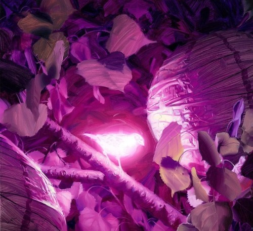


Bioluminescence series by Rob Rey
(Rob Rey’s Tumblr)
150K notes
·
View notes
Link
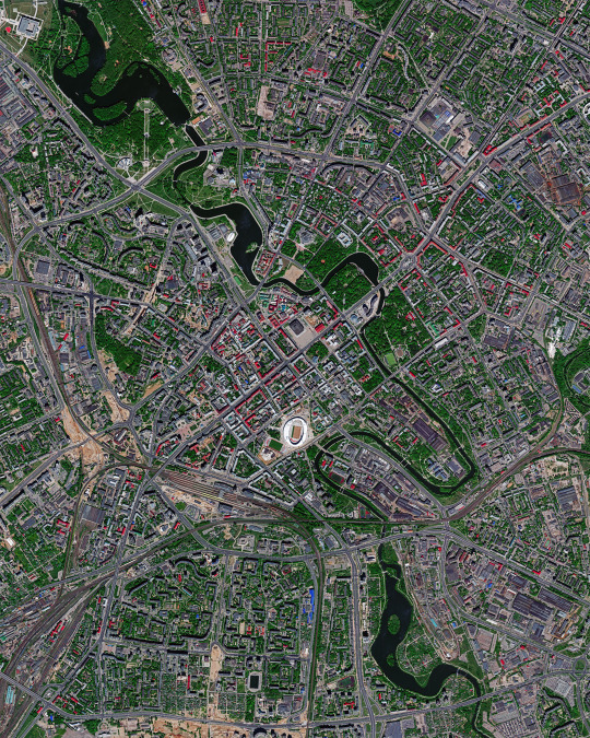
“Listen,” says the mayor, opening the windows of his office. From the street below rises the sound of human voices. “Before I became mayor 14,000 cars passed along this street every day. More cars passed through the city in a day than there are people living here.”
Miguel Anxo Fernández Lores has been mayor of the Galician city since 1999. His philosophy is simple: owning a car doesn’t give you the right to occupy the public space.
“How can it be that the elderly or children aren’t able to use the street because of cars?” asks César Mosquera, the city’s head of infrastructures. “How can it be that private property – the car – occupies the public space?”

a metro-style map of pontevedra shows typical walking times.
“They stopped cars crossing the city and got rid of street parking, as people looking for a place to park is what causes the most congestion. They closed all surface car parks in the city centre and opened underground ones and others on the periphery, with 1,686 free places. They got rid of traffic lights in favour of roundabouts, extended the car-free zone from the old city to the 18th-century area, and used traffic calming in the outer zones to bring the speed limit down to 30km/h.
The benefits are numerous. On the same streets where 30 people died in traffic accidents from 1996 to 2006, only three died in the subsequent 10 years, and none since 2009. CO2 emissions are down 70%, nearly three-quarters of what were car journeys are now made on foot or by bicycle, and, while other towns in the region are shrinking, central Pontevedra has gained 12,000 new inhabitants. Also, withholding planning permission for big shopping centres has meant that small businesses – which elsewhere have been unable to withstand Spain’s prolonged economic crisis – have managed to stay afloat.

flickr/rodolforamallo
“The city is the perfect size for pedestrianisation,” says local architect Rogelio Carballo Soler. “You can cross the entire city in 25 minutes. There are things you could criticise, but there’s nothing that would make you reject this model.”
read more: guardian, 18.09.18.
24K notes
·
View notes
Photo

Malé is the capital and most populous city in the Republic of Maldives, a nation of islands in South Asia. With a population of about 133,000 in an area of 2.24 square miles (5.8 square km), it is the fifth most densely populated island on Earth. Since it has no surrounding countryside, all of Malé’s utilities are located in the city proper and sewage is pumped unprocessed into the sea.
See more here: https://bit.ly/32OS4qq
4.175278°, 73.508889°
Source imagery: Maxar Technologies
#world from above#look at this little radish#if you pay attention#you will do well in my instagram quizzes
242 notes
·
View notes
Photo

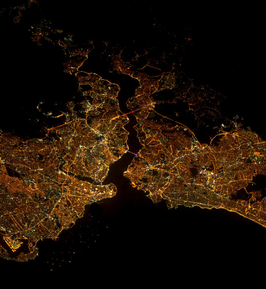

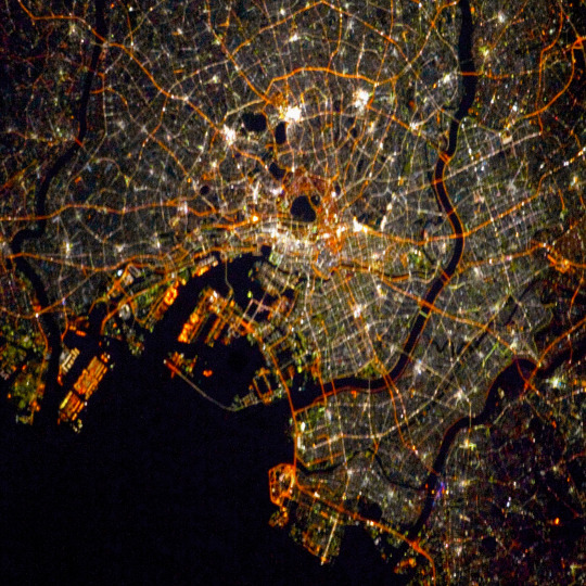
Check out these four “Cities At Night” images from our Young Explorer’s Edition book that was just released today! These cities, in order, are:
1. Chicago
2. Istanbul
3. London
4. Tokyo
See more here: https://bit.ly/34eGnK9
Source imagery: NASA - National Aeronautics and Space Administration
465 notes
·
View notes
Photo
Minsk is the capital and largest city of Belarus, situated on the Svislač River. Home to just under 2 million people, it is a modern city characterized by monumental Stalinist architecture — grand buildings, broad avenues and wide squares. In recent years, Minsk has been continuously decentralizing and more development is planned for several areas outside the city centre.
See more here: https://bit.ly/33cj1Vb
53.900000°, 27.566667°
Source imagery: Maxar Technologies
132 notes
·
View notes
Photo
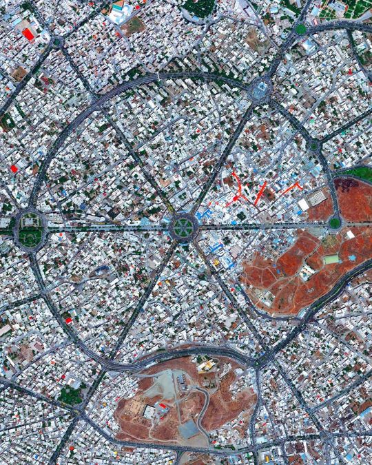
Location | Hamedan, Iran
Hamedan is believed to be among the oldest Iranian cities dating back earlier than 1100 BC, and also being the capital city at one point. The city is located more than 1,800 meters above sea level and has green mountainous surroundings.
Hamedan city is circular and is formed by Imam Khomeini square (or Hamedan Square as seen in the middle of the photo), the square where six main streets of the city meet. The square as we see it today was created based on a hexagram shape in 1928, designed by German planners and architects.
#hamedan #imamkhomeinisquare #hamedansquare #iran #همدان #urbanplanning #cityplanning #worldurbanplanning #architecture #landscapearchitecture #city #urbanpatterns #aerial #aerialview #drone #topdown #도시계획 #이란 #citydesign #hexagram #roundabout #square #plaza (at Hamedan)
https://www.instagram.com/p/B4XOdV5gHfi/?igshid=u6wo7d3anszr
33 notes
·
View notes
Photo

Seoul is the capital and largest metropolis of South Korea, with more than 25 million residents in its metropolitan area. Strategically situated on the Han River, Seoul’s history can be traced back more than 2,000 years to 18 BC, when it was founded by members of the Baekje Kingdom. In recent years, the city has experienced massive economic growth and is one of the top 10 wealthiest cities in the world with a GDP of more than $700 billion (USD).
Instagram: https://bit.ly/30z4sKd
37.566667°, 126.966667°
Source imagery: Maxar Technologies
369 notes
·
View notes
Photo

This Overview captures the tightly gridded streets of Nezahualcóyotl, a municipality of Mexico City. With a population of more than one million, this area is home to many of the capital’s citizens who have migrated there from other parts of the country. The Greater Mexico City area has roughly 21 million residents, making it the largest metropolitan area in North America.
Instagram: https://bit.ly/2uh88l6
19°24'26.8"N, 99°01'40.2"W
Source imagery: DigitalGlobe
259 notes
·
View notes


Photo


Spider-Man: Into the Spider-Verse ( art dump part ¼ )
Yay we won the Oscars~ Here are some of the art and design I did for Spider-Verse. I included some sketches to show my process. Feel very proud and lucky to be part of this project~ Congrats to Sony and the team!
36K notes
·
View notes
Photo

Jelsa is a town located on the island of Hvar in Croatia. It was founded in the 14th century as a port for a nearby inland village, and currently has about 3,600 residents. During the 19th century, Jelsa was one of the most significant maritime, shipbuilding and trade centers on the Adriatic Sea.
Instagram: https://bit.ly/2HueRA6
43°09'40.0"N, 16°41'35.0"E
Source imagery: Grant Ritchie (@grantritchie)
188 notes
·
View notes
Photo

Evaporation ponds are seen at the Intrepid Potash Mine in Moab, Utah, USA. The mine produces muriate of potash, a potassium-containing salt used widely by farmers in fertilizer. The salt is pumped to the surface from underground brines and dried in massive solar ponds that vibrantly extend across the landscape. As the water evaporates over the course of 300 days, the salts crystallize out. So why are you seeing such vibrant colors? The water is dyed with these vibrant colors to reduce the amount of time it takes for the potash to crystallize; darker water absorbs more sunlight so it gets hotter and the water evaporates quicker.
38°29'08.1"N, 109°41'04.6"W
Source imagery: DigitalGlobe
662 notes
·
View notes
Photo
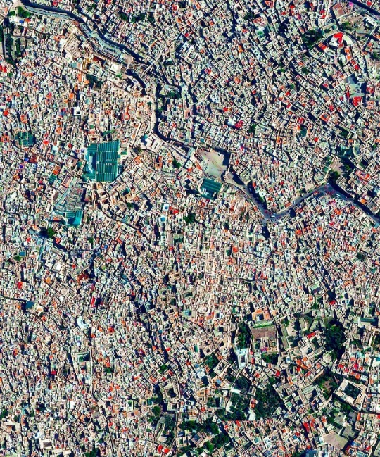
Fes el Bali is the oldest walled part in the city of Fez, Morocco. With a total population of 156,000, the area is believed to be the biggest car-free urban neighborhood in the world due its narrow streets that are only two feet wide in some sections.
34°03′40″N 04°58′40″W
Source imagery: DigitalGlobe
219 notes
·
View notes
Photo

I’ve been asked to post my process since forever and I finally got around to recording it this time. I don’t think I’ll ever film myself painting because I get very self conscious doing it (it feels like someone is watching me, ew) but I was curious to see the overall process myself. This is not a step by step procedure and I’m generally speaking a very messy worker but it gets the job done lol. and ps, i won’t be answering questions regarding my art process/know-hows after this post i think it speaks for itself.
ig / twitter / prints
3K notes
·
View notes
Photo
Shared because of unusual projection
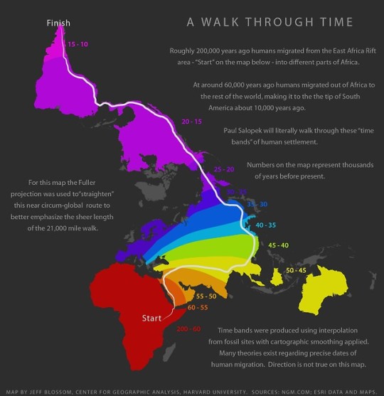
Path of human migrations.
901 notes
·
View notes
Photo

Check out this amazing Overview of Chicago, Illinois, and Lake Michigan during last week’s polar vortex. Captured Thursday by the European Space Agency’s Sentinel-2 satellite, it shows the entire city covered in snow with massive chunks of lake ice floating offshore. Chicago finished off the month of January with 13 consecutive days of snow and some of its coldest temperatures in more than three decades.
Instagram: https://bit.ly/2UKjkCh
41°50'13.0"N, 87°41'05.0"W
Source imagery: ESA - European Space Agency via Descartes Labs
651 notes
·
View notes