#photosouthwest
Photo
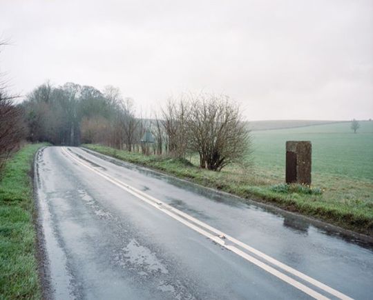
'Wiltshire', Robbers Stone, Gore Cross 2019 On a road between West Lavington and Gore Cross on Salisbury Plain there is one of two stones erected to commemorate a highway robbery that went wrong. This, the first stones of the two marks the spot of where the robbery happened. The transcription on the stone reads, “AT THIS SPOT Mr. DEAN, of Imber. was attacked and Robbed by four Highwaymen, in the evening of Octr. 21st. 1839. After a spirited pursuit of three hours one of the Felons BENJAMIN COLCLOUGH fell dead on Chitterne Down. THOMAS SAUNDERS, GEORGE WATERS, & RICHARD HARRIS, were eventually Captured, and were convicted at the ensuing Quarter Sessions at Devizes, and transported for the term of Fifteen Years. This Monument is erected by Public Subscription as a warning to those who presumptuously think to escape the punishment God has threatened against Theives and Robbers.” The second stone is erected on Chitterne Down, making the spot where one of the robbers died after being chased. The transcription on the second stone reads, “This Monument is erected to record the awful end of BENJAMIN COLCLOUGH a Highway Robber who fell Dead, on this Spot, in attempting to escape his Pursuers after Robbing Mr Dean of Imber, in the Evening of Oct 21st 1839, and was buried at Chitterne without Funeral Rights. The robbery of the wicked shall destroy them. Prov. 21. 7. His three companions in Iniquity THOMAS SAUNDERS GEORGE WATERS & RICHARD HARRIS were captured & sentenced at the ensuing Quarter Sessions at Devizes to Transportation for the Term of Fifteen Years. Though hand join in hand the wicked shall not be unpunished Prov 11. 21”
posted on Instagram - https://ift.tt/2Rw0ekM
2 notes
·
View notes
Photo

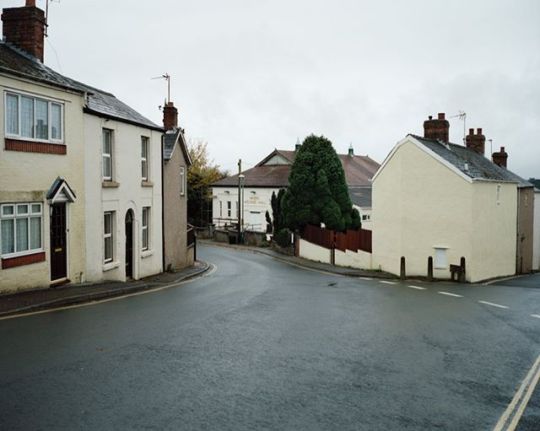
'Wiltshire', Hinton Parva 2019 Hinton Parva, (also known as Little Hinton) is a small village just south of Swindon, sitting on the slopes of the Lambourne Downs. During WWII in 1943 as the Western allies were preparing for the invasion of Europe, many Wiltshire villages were being used as makeshift barracks for the huge influx of allied soldiers. Many villagers lived alongside the servicemen, but some were completely evicted for the military to carry out their activities, most famously so in Imber. Hinton Parva was also evacuated by the War Office for tanks to be stored before the offence. Unlike Imber, when the war was over the residents were allowed to take back what was theirs in Hinton Parva.
posted on Instagram - https://ift.tt/2XZWQjx
2 notes
·
View notes
Photo
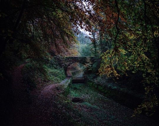
Archive: 'Gloucestershire', Thames and Severn Canal, Cotswolds 2015 The canal was opened in 1789, with the idea of connecting Bristol to London via canal. As the name suggests, at it’s eastern end it connects into the Thames near Lechalde, and at the western end it connects to another canal, Stroudwater Navigation which leads to the River Severn. At the highest point of the canal is the Sapperton Tunnel. The tunnel is 2.17 miles long and cuts through the Cotwolds hills. When built, it was the longest tunnel of any kind in the UK, and like many canals of the time it’s success was short-lived thanks to the arrival of the railway network. During the majority of the 19th century, the canal battled to compete financially, but in failing, the canal fell into poor condition. With this and an issue with keeping water levels high enough at the summit it led to being completely abandoned in 1933.
posted on Instagram - https://ift.tt/2PPoygF
2 notes
·
View notes
Photo

'Wiltshire', Savernake Forest, Marlborough 2018 Situated on a chalk plateau just outside Marlborough, Savernake Forest is Britain’s only privately owned forest and home to a concentration of “Veteran” trees that is said to be the highest in Europe. The oldest being ‘Big Belly Oak,’ thought to be over 1100 years old and one of the fifty Great British trees named and honoured as part of the Queen’s Golden Jubilee celebrations. King Henry VIII temporarily resided in Savernake in 1535 to hunt in the forest with Sir John Seymour. It is believed that during these hunting trips he met his future wife Jane Seymour.
posted on Instagram - https://ift.tt/3496CRV
1 note
·
View note
Photo
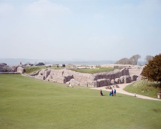
'Wiltshire', Old Sarum 2019 The original site for the earliest settlement of Salisbury located North of Salisbury today. Evidence of a prehistoric settlement have been discovered from 3000BC onwards. An Iron Age hill fort was built around 400BC to help control local trade paths. Occupation of the site continued throughout the Roman and Saxon period. The biggest change on Old Sarum came during the Norman period, with construction of a motte and bailey castle in 1070, and the building of a stone wall around the settlement and a cathedral completed in 1092. For the next couple of hundred years the settlement enjoyed its best years, with the Cathedral being refurbished and expanding the building to double the length in 1110’s. King Henry I then decided to build a royal palace within the curtain walls in 1130’s. Once the city continued to grow there was a apparent problem with lack of water in the settlement, so much that water was sold at inflated prices which led to talk of the Cathedral moving. In the late 11th and early 12th century the decision was made to move the Cathedral from Old Sarum to a new site. This was due to lack of water and the Cathedral repeatedly being damaged by wind and soldiers of the royal fortress restricting common folk access to the cathedral on serval occasions. Pope Honorius III agreed to the relocation and in 1220 building work began on the new Cathedral, and the settlement that grew around it was Salisbury. The settlement shows evidence on continued habitation but much of Old Sarum was razed to the ground to be used in the new settlement. In 1322 Edward II order for the castle to be demolition.
posted on Instagram - https://ift.tt/33XnkUd
1 note
·
View note
Photo
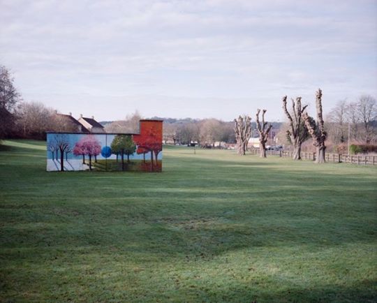
'Wiltshire', Tidworth 2019 A small village for most of its history, Tidworth didn’t change until in 1897, when the War Office purchased Tedworth house and a large area of land by the village. This was the start of Tidworth Camp, and Southern Command headquarters were established there in 1905. The growth of the military camp was mirrored by the growth of Tidworth into a garrison town (a town containing a military base). By 2011 the population of the parish is 10,600. The town has one of the lowest crime rates in Wiltshire and was rated by the Royal Mail as the most attractive postcode area to live in 2014.
posted on Instagram - https://ift.tt/36dgQlI
1 note
·
View note
Photo
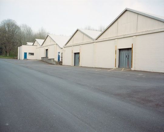
'Wiltshire', BCAC Hangers, Larkhill 2019 Larkhill was the site of the first army aerodrome. This short-lived aerodrome started when flying enthusiast Horatio Barber rented land to fly and store his plane in 1909, and was followed by others soon after. The War Office began to see the importance of aviation in war; because of this the aerodrome began to grow. Companies such as British & Colonial Aeroplane Company (which later became the Bristol Aeroplane Company) decided to build hangers at Larkhill. In 1912 the aerodrome held the first military aeroplane trials. With the continual successes of aviation in the Western world, other aerodromes around the country started to open and created competition for Larkhill. Although it was the first of it’s kind, Larkhill closed in 1914. All that is left of the aerodrome are the original BCAC hangers, which are now the oldest surviving aerodrome building in the UK and are grade II* listed structures.
posted on Instagram - https://ift.tt/2qolBtb
1 note
·
View note
Photo

'Wiltshire', Salisbury Cathedral 2019 The painter John Constable became friends with John Fisher, (former Bishop of Salisbury) between 1807 and 1825. First visiting Fisher in Salisbury in 1811, their friendship grew over time, with Fisher officiating Constable’s marriage in 1816, and also commissioning a painting of Salisbury Cathedral. Fisher soon became Constable’s biggest patron, helping fund Constable for many years. Salisbury Cathedral and the surrounding landscape inspired many of Constable’s most notable paintings. When John Fisher died, Constable even commemorated him in a painting of his house.
posted on Instagram - https://ift.tt/2DsC42i
1 note
·
View note
Photo

'Wiltshire', The Spa, Melksham 2019 ‘Melksham Spa Company’ was formed in 1815 by a group of local gentlemen looking to invest their money from the declining textile industry. The springs were located after several attempts to find coal. With their investment they built six large semi-detached houses in a crescent with private hot and cold baths. With plans to extend the Spa area with a further crescent, the Spa prospered for several years but due to it’s close proximity to Bath it struggled to compete and closed. The buildings are now private residences.
posted on Instagram - https://ift.tt/2Obk8PU
1 note
·
View note
Photo

'Wiltshire', St John the Baptist Church, Inglesham 2019 The church has Anglo-Saxon origins; the existing structure built in the early 13th century. Situated in water meadows near the river Thames, the church has changed very little from the medieval era. This was due to the church being saved from a unsympathetic restoration 1880’s by William Morris who lived near by, saving its medieval features and identity. The church is now in the care of the churches conservation trust after it was declared redundant in 1980.
posted on Instagram - https://ift.tt/37fLPyM
1 note
·
View note
Photo
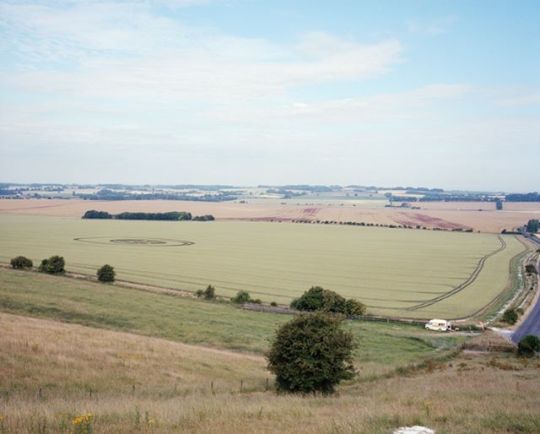
'Wiltshire', Hackpen Hill, Marlborough Downs 2018 Crop Circles have been recorded since the 15th century, but it wasn’t until the 1970’s that they became as frequent or as complicated as they are now. The term ‘Crop Circle’ wasn’t coined until the late 1970’s or early 80’s. By the late 80’s the phenomenon became main stream with the media taking notice because of the mysteries of their creation. Many of the crop circles are positioned near cultural or heritage monuments, making Wiltshire the UK’s crop circle capital, mainly with acknowledgement to Avebury and Stonehenge, with nearly half of all recorded crop circles being placed within 15km of Avebury in 2003. In 1990 Led Zeppelin used a photograph of a crop circle near Alton Barnes, Wiltshire for the cover of “Remasters”. Crop Circles continued to be made and still attract a lot of enthusiasts and tourists with farmers charging to see the crop circles and selling merchandise.
posted on Instagram - https://ift.tt/2X0m0Oc
1 note
·
View note
Photo

Archive: 'Gloucestershire' Kings Walk Shopping Centre, Gloucester 2015 Gloucester was founded in AD 48 as a Roman fort and market and called Glevum. The fortress was founded at this location because of the important crossing of the River Severn, as this gave the Roman Legion future access and a base to invade Wales from. It is thought that at its height Glevum would have had a population as large as 10,000 people and much of the area around the town would have been heavily Romanised. Gloucester was captured by Saxons in 577 and continued to grow throughout The Middle Ages. This was thanks to its situation on the River Severn, the founding of the abbey of St Peter (681) and the export of wool from the Cotswolds. Modern day Gloucester still resembles its past, with the city centre still laid out as a cross where the four main historic streets meet (Northgate, Southgate, Eastgate and Westgate Streets).
posted on Instagram - https://ift.tt/36vEaMo
1 note
·
View note
Photo

Archive: 'Gloucestershire', Wimberry Slade Valley, Forest of Dean, 2016. The valley has a long history with mining and quarrying. The largest colliery near the site was the Cannop Colliery, viewed as one of the most successful collieries in the forest, but came to a close in 1961. The site of the colliery has now been redeveloped with some old buildings being reused by a cycle hire centre, the old bathhouse used by a highway maintenance company and a large car park placed over the two capped mine shafts. Within the valley itself, there are many old sites used by Freeminers and one still in operation. A ‘Freeminer’ is a title given to some miners in the forest of dean. The Forests coalfield have been regulated through a system of Freemining since at least the 15th century. To be eligible, you need to have been born and live within the area of the ‘Hundred of St Briavels’, be at least 21 years old and to have worked for over a year in a mine also within the ‘Hundred of St Briavels’. The ancient district known as the Hundred of St Briavels is now generally considered to be anywhere within the Forest of Dean. In 2010 there was also a change, with women being allowed to register to be a Freeminer for the first time. Now there is believed to be around 150 Freeminers alive, but only a handful of collieries still operating.
posted on Instagram - https://ift.tt/36gvY2n
1 note
·
View note
Photo

Archive: 'Gloucestershire', Bixslade Valley, Forest of Dean, 2014. Bixslade is a short and steep sided valley which has been been mined and quarried for over 500 years. Because of this it has been described as a ‘one of the country’s finest areas of extractive industrial heritage’. Along the length of valley is a footpath that follows the old route of the Bicslade Tramroad, which opened in 1812 and continued to be in use until 1950 making it the last working horse powered tramroad in the forest. There are still three quarries and a freemine named ‘Monument Colliery’ operating in the valley.
posted on Instagram - https://ift.tt/2lN9q6P
1 note
·
View note
Photo

Thanks to @on_landscape for sharing my ‘Wiltshire’ project on their website. Check it out or take a look all the great photographer’s work they share. ・・・ @tedhomer1 writes "My latest project ‘ is fundamentally about the heritage in our landscape. Kept, lost or rediscovered, our landscape is brought into question more than ever before; how we try to preserve our heritage and natural aesthetic, but also how we try to utilise our land for new uses."
posted on Instagram - https://ift.tt/31GSoXX
1 note
·
View note
Photo
Archive: 'Gloucestershire', Cinderford, Forest of Dean, 2016. Before the 18th century, there was very little in the way of any permanent settlements within the Forest of Dean, apart from one small town of Cinderford. Much of the population was set up in illegal settlements made up of makeshift cabins on Crown land. The illegal settlers had to move in order to find work and for the threat of expulsion. With industry and the population growing many settlers wanted to make permanent settlements, and so moved to the edge of the Crown owned forest and created roughly built hamlets. Overtime these hamlets became well established, and still exist like Parkend and Berry Hill. Industry continued to be the main employer within the forest, with the coal industry itself employing half of the male working population up until 1945. 20 years later the last large colliery, Northern United would close.
posted on Instagram - https://ift.tt/34GNQm7
1 note
·
View note
Last Seen Blogs

sirenetica
Siren

cozy-clover-witch
♧Clover Witch♧

yaeemizx
Anime Icons

scubawario007
Wario Locker

sanderssidesfanfiction
A Mob Stuffed In A Trenchcoat