#Mount Ruang
Text
Tsunami alert in Indonesia as Mount Ruang volcano erupts
Officials fear part of volcano could collapse into sea #press
#tsunami alert#tsunami#alert#alerts#indonesia#mount ruang#volcano#alerta#signal boost#signal b00st#signal boooooost#volcanos#volcanic#extreme weather#weather#nature#this has been a psa#important psa#psa#just fyi#just a general fyi#also fyi#fyi#ausgov#politas#auspol#tasgov#taspol#australia#fuck neoliberals
50 notes
·
View notes
Text

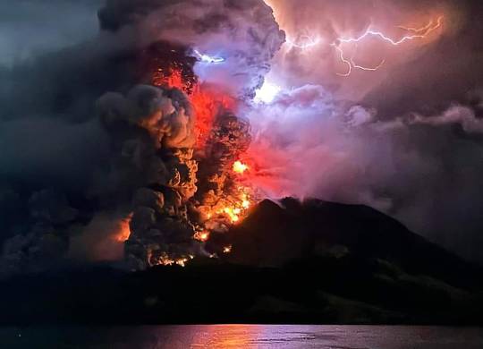
Mount Ruang eruption at North Sulawesi province in the Sangihe Islands, Indonesia
#nature#Mount Ruang#North Sulawesi#Sangihe Islands#Indonesia#eruption#outdoor#travel#photography#volcano
32 notes
·
View notes
Text
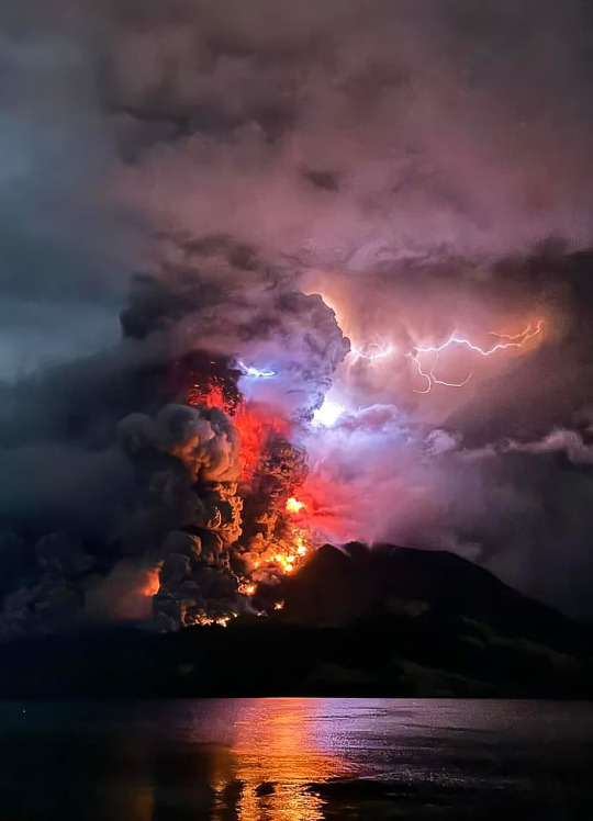
Mount Ruang spews lava and smoke as seen from Sitaro, North Sulawesi, in Indonesia on Wednesday, April 17th. (Source: -/AFP/Getty Images)
youtube
#geology#volcano#eruption#stratovolcano#volcanic lightning#Mount Ruang#Sitaro#North Sulawesi#Indonesia#Youtube
3 notes
·
View notes
Text
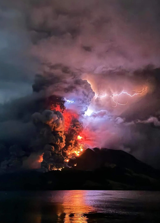
Mount Ruang spewing hot lava and smoke as seen from Sitaro, Indonesia, on Wednesday. Credit...Center for Volcanology and Geological Hazard Mitigation/AFP via Getty Images
12 notes
·
View notes

Text

https://www.reuters.com/world/us-democrats-press-biden-prevent-israeli-assault-rafah-2024-05-01/
4 notes
·
View notes
Text
youtube
Indonesia has issued a tsunami warning and declared its highest level of alert following a series of volcanic eruptions. Mount Ruang spat out a column of ash three kilometres high - accompanied by lightning bolts - as it erupted five times over the past two days. The threat of rock slides prompted authorities to warn residents of the danger of tidal surges. Thousands of people have been evacuated from the remote northern island where the volcano is located.
4 notes
·
View notes
Text
NOW! Volcanic threat to Indonesia! Powerful eruption of Mount Ruang!
youtube
⚠️🍀🤞
2 notes
·
View notes
Text
//The Wire//2100Z April 17, 2024//
//ROUTINE//
//BLUF: CANADIAN PIPELINE EXPLOSION CAUSES WILDFIRE.//
-----BEGIN TEARLINE-----
-International Events-
Canada: A wildfire has spread in Alberta following the explosion of a natural gas pipeline near Edson yesterday morning. Overnight the fire expanded to 10 hectares in size, and is currently being worked by wildland fire crews.
Indonesia: A tsunami warning was issued for Tagulandang following the violent eruption of Mount Ruang, a major volcano located in the eastern Celebes Sea. Thousands of locals have been evacuated as the volcanic eruption continues.
Georgia: Several thousand protesters gathered in Tblisi to protest a recent collection of laws which critics say allows more crackdown on dissident speech.
-HomeFront-
USA: Congressional Republicans have announced several new spending bills, all related to foreign aid. So far, Ukraine’s bill includes $61 billion, Taiwan’s includes $8 billion, and Israel’s includes $26 billion.
-----END TEARLINE-----
Analyst Comments: The cause of the initial pipeline rupture in Canada has not been publicly released, and is currently under investigation. However, due to the sensitive nature of pipeline security incidents, it is very unlikely that any details will be made public as to whether or not a security incident was to blame for the explosion. However, taking into account the very obvious atmospherics that deliberate infrastructure attacks are to be expected at this time of heightened international conflict, it would be prudent to remain situationally aware as more incidents involving critical infrastructure occur.
Analyst: S2A1
//END REPORT//
2 notes
·
View notes
Link
0 notes
Text
Volcanish Ash on The Leaves of One of The Plants
Volcanic ash on the leaves of one of the plants in my grandmother's house. This is the result of the eruption of Ruang Volcano which is located in the Sangihe Islands, although I live in Manado City which is more than 100 kilometers (62 miles) from this volcano.
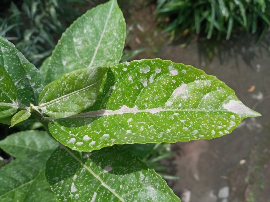
Luckily I don't live near a volcano…actually I live near a volcano but it's an extinct volcano, it's Mount Klabat and it is the highest mountain in North Sulawesi Province, about 1,995 meters or more than 6,500 feet. It would be more exciting if it erupted again.
Taken on Wednesday, 1 May, 2024 at 10:18 with Samsung Galaxy A10s.
#sofiaflorina#ruang volcano#gunung ruang#eruption#eruptions#volcano#volcanoes#volcanos#volcano eruption#volcanic eruption#volcanic ash#volcanic#manado#manado city#kota manado#sulawesi utara#north sulawesi#sulawesi island#sulawesi#leaf#leaves#plant#plants#plants of tumblr#plant photography#plant blog#mountain ash#nature
1 note
·
View note
Text
Indonesia's Mount Ruang erupts again, spewing ash and peppering villages with debris - news today
MANADO, Indonesia (AP) — Indonesia’s Mount Ruang volcano erupted Tuesday for a second time in two weeks, spewing ash almost 2 kilometers (more than a mile) into the sky, closing an airport and peppering nearby villages with debris.
The alert level of the volcano on Sulawesi Island was again raised to the highest level by the Indonesian geological service, after sensors picked up increasing…
View On WordPress
0 notes
Text
A powerful volcano is erupting. Here’s what that could mean for weather and climate
A powerful volcano is erupting. Here’s what that could mean for weather and climate
Mary Gilbert, CNN Meteorologist
Tue, April 23, 2024 at 6:47 AM MST��4 min read
423
https://s.yimg.com/rx/ev/builds/1.5.13/pframe.html
Scroll back up to restore default view.
When Mount Ruang in Indonesia underwent multiple explosive eruptions last week, volcanic gases were flung so high they reached the…

View On WordPress
0 notes
Text
A Blanket of Ash from Ruang
Ruang is a small volcanic island in the Sangihe Islands arc in North Sulawesi, Indonesia, that is home to about 800 people. Late on April 16, 2024, the mountain roared to life, unleashing a series of explosive eruptions that, at times, sent plumes of ash and gas billowing high into the stratosphere. The eruption also bombarded the island with tephra, small pebbles of lapilli, and fine shards of pulverized rock called ash.
The pair of Landsat satellite images above highlights how the eruption transformed the landscape. The OLI-2 (Operational Land Imager-2) captured an image on April 12 (top) that shows Ruang’s lush green vegetation before the eruption; the OLI (Operational Land Imager) image, acquired on April 20 (lower), shows the same area after volcanic debris had blanketed the island. The image also shows signs of pyroclastic flows—destructive torrents of hot ash, rock, soil, and gas—that poured down the mountain’s slopes and left thick deposits at the base.
Settlements on the north side of the island were among the hardest hit with volcanic debris. On the west side, tephra also blanketed Laingpatehi, the island’s largest village. The bright white features obscuring parts of the island are likely passing clouds, though some of them could be volcanic plumes emitted by the still-active volcano.
According to initial assessments by Badan Nasional Penanggulangan Bencana (BNPB), Indonesia’s disaster management agency, heavy ashfall and volcanic rock fragments severely damaged or destroyed more than 500 houses. It also damaged crops and farms.
The ash posed a hazard to aviation, prompting widespread flight cancellations and diversions. Authorities closed the Sam Ratulangi International Airport in the nearby provincial capital of Manado due to the ash, disrupting travel for thousands of people. The airport reopened on April 22, after rainfall washed away ash on the runway, and after BNPB had lowered the volcanic alert level.
A geostationary satellite operated by the Japan Meteorological Agency and polar-orbiting satellites operated by NASA and NOAA all observed ash and sulfur dioxide streaming from Ruang as the volcano erupted.
According to Ghassan Taha, an atmospheric scientist at NASA’s Goddard Space Flight Center, data from the Ozone Mapping and Profiler Suite (OMPS) Limb Profiler (LP) show that the volcanic plume reached an altitude of about 20 kilometers (12 miles) and into the stratosphere, the second layer of the atmosphere above the ground. Atmospheric scientists monitor the amount of particles and gases that volcanoes inject into the stratosphere because material reaching this height can spread widely and have global effects on the climate.
“We expect to see aerosol particles circulating in the stratosphere for weeks, if not months,” Taha said.
In recent decades, volcanic eruptions have injected material into the stratosphere about once a year. However, the injection of at least 5 teragrams of sulfur dioxide is generally required to produce enough aerosol particles to temporarily change the reflectivity of the upper atmosphere, according to climatologists. In most cases, the amount of material reaching the stratosphere has been modest and below that threshold.
After the eruption at Ruang, an infrared sensor on the geostationary Himawari satellite measured a total emission of about 0.5 teragrams of sulfur dioxide on April 17, according to Simon Carn, a volcanologist at Michigan Technological University. The following day, other satellites measured about 0.3 teragrams. “The actual sulfur dioxide emission was probably between 0.3 and 0.5 teragrams, well below the threshold for significant climate impacts,” Carn said.
The 1991 eruption of Mount Pinatubo in the Philippines, which caused a global cooling of about 0.5 degrees Celsius (0.9 degrees Fahrenheit) for about a year, released approximately 20 teragrams of sulfur dioxide into the stratosphere. More recently, the 2022 Hunga Tonga-Hunga Ha’apai eruption injected an estimated 0.5 to 1 teragrams.
Ruang, whose name means “space” or “room” in the local Bugis language, has a long eruptive history and is one of Indonesia’s most active and dangerous volcanoes. Major explosive eruptions have occurred in 1634, 1670, 1843, 1871, 1904, 1956, and 2002, according to the Global Volcanism Program. The 1871 eruption triggered a tsunami that devastated a village on a nearby island and caused hundreds of deaths.
Officials warned the 2024 eruption could trigger lahars—volcanic mudflows—as rain intermingles with fallen ash in the coming days and weeks. The eruption also raised fears of potential tsunamis from volcanic flows entering the sea, prompting multiple tsunami warnings, though no significant tsunamis have occurred, according to the local volcanic survey (PVMBG) and BNPB. Indonesian authorities coordinated the evacuation of over 16,000 residents from areas most at risk of pyroclastic flows, ash falls, and tsunamis. Since the eruption began, no deaths or injuries have been reported.
NASA Earth Observatory images by Michala Garrison, using Landsat data from the U.S. Geological Survey. Story by Adam Voiland.
1 note
·
View note
Text

https://www.reuters.com/world/us/microsoft-finds-russian-influence-operations-targeting-us-election-have-slowly-2024-04-17/
2 notes
·
View notes
Last Seen Blogs

yesiamgaylord
👁👄👁

sanfangzhu
Sanfangzhu

luminancelight
LuminanceLight

tahatturr-blog
şiir misin sen?

joselincabrouniverse
OSCILANDO