#goeswest
Text
Spectacular transverse banding is beginning to splay out around Hurricane
#Norma as seen in #GOESWest IR and Water Vapor rapid scan imagery over the
past hour. #HurricaneNorma is expected to approach the southern portion of
Baja California Friday night.
0 notes
Text
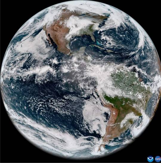
Heads up! NOAA Satellite and Information Service's GOES-18, launched in March 2022, is now #GOESWest. Miles above Earth, it’ll observe the Western Hemisphere, helping weather forecasters, emergency managers, and all who want to know more about our changing planet. @iasarunmishra
Take a look: https://go.nasa.gov/3Z5SB5b
0 notes
Photo

Reason #12456457 why I'm interested in meteorology! Weather and earth science is endless and its power is incredible. These videos are from the mostly underwater volcanic eruption that happened near Tonga Friday evening. IMAGE 1: Is a satellite view from satellite #GOESWest of the volcanic ash cloud eruption. If you pay close attention you will see the shockwaves expand outward. IMAGE 2: Is an infrared view also from #GOESWest. It is beyond incredible to see the contrast in what is going on here scientifically. You see the warmth of the ash cloud as it interacts with the cold of the troposphere and expands out. Might not mean much to some, but my science brain is amazed. Again, if you pay close attention you will see the shockwaves from the explosion expand outward. https://www.instagram.com/weathergirl8/p/CYxPtTmJKBA/?utm_medium=tumblr
13 notes
·
View notes
Photo
William Tyler “Goes West” on Indie Exclusive green vinyl just in! #NewRelease #NewArrivals #Vinyl #WilliamTyler #GoesWest #ColoredVinyl #LimitedEdition #IndieExclusive #ShopLocal #BrickAndMortar #Visalia #WaxWars #VelouriaRecords (at Velouria Records) https://www.instagram.com/p/BtRUfFPBnMG/?utm_source=ig_tumblr_share&igshid=hn441yur141h
#newrelease#newarrivals#vinyl#williamtyler#goeswest#coloredvinyl#limitededition#indieexclusive#shoplocal#brickandmortar#visalia#waxwars#velouriarecords
0 notes
Photo

@RoughTradeNYC @WilliamTylerTN (of @LambchopIsABand & @SilverJews) played solo show to herald his upcoming @MergeRecords LP #GoesWest, spinning intricate instrumental acoustic threads into a tapestry of folk-country songs that reminded me of Richard Thompson, Pete Townshend, Bert Jansch, and Roddy Frame Setlist included: #CallMeWhenImBreathingAgain #FailSafe #ManInAHurry #EventualSurrender #VirginiaIsForLoners #NotInOurStars #GoneClear #SunkenGarden #GoodMusic #WilliamTyler #AcousticGuitar #Brooklyn #Williamsburg #RoughTradeNYC #Lambchop #SilverJews (at Rough Trade NYC) https://www.instagram.com/p/BtAM5XlFYy2/?utm_source=ig_tumblr_share&igshid=q7l5ylgd6add
#goeswest#callmewhenimbreathingagain#failsafe#maninahurry#eventualsurrender#virginiaisforloners#notinourstars#goneclear#sunkengarden#goodmusic#williamtyler#acousticguitar#brooklyn#williamsburg#roughtradenyc#lambchop#silverjews
0 notes
Photo

Out here on the @smallgirlswest coast 🌴, building that (small) #girlpower vibe 📈 + 💡✨ 💕 sign by @nameglo #PR2D2 @smallgirlspr #C3PR #goeswest #nameglo (at Small Girls West)
2 notes
·
View notes
Text

🎧 Novidade: “Fail Safe” de William Tyler 🌞⛰👁
🔊 https://youtu.be/br4BRG_RXO0
📀 Goes West via Merge Records
undefined
youtube
0 notes
Photo

On January 25, 2017, @hopebarb and I start an epic journey. We're moving to Los Angeles to step up the soigné in our radical culinary careers and also skip the rest of winter. #goforth #maddecent #dece #callyourmother #californiatrail #fordtheriver #caulkthewagonandfloatit #youhavediedofdysentery #youwereonlyabletocarry100poundsbacktothewagon #oxwandersofflose2days #journey #dontstopbelieving #soigné #maytheforcebewithus #bringsnacks #gottapee #arewethereyet #iwillturnthiscararound #dontgetlost #barb #goeswest #chewieismycopilot (at Syracuse, New York)
#chewieismycopilot#dece#caulkthewagonandfloatit#barb#gottapee#goeswest#soigné#dontstopbelieving#maytheforcebewithus#californiatrail#youwereonlyabletocarry100poundsbacktothewagon#iwillturnthiscararound#journey#bringsnacks#goforth#callyourmother#oxwandersofflose2days#fordtheriver#arewethereyet#youhavediedofdysentery#dontgetlost#maddecent
0 notes
Video
youtube
Watch William Tyler soundtrack a Bakersfield line dance in his new video for “Fail Safe.” His new album Goes West is out Friday! http://smarturl.it/GoesWest
3 notes
·
View notes
Photo

West End - Come From Away & Anything GoesWest End – Come From Away & Anything GoesThat’s...
0 notes
Text
شاهد.. صور “ناسا” و”نوا” المتحركة لإعصار دوريان من الفضاء

تواصل الأقمار الصناعية التي تديرها وكالة ناسا الأمريكية والإدارة الوطنية للمحيطات والغلاف الجوي (NOAA) تتبع حركة إعصار دوريان وتقدمه، حيث يعد إعصار دوريان الآن عاصفة من الفئة الخامسة، والذى يقترب من جزر أباكوس وجزر الباهاما.
ونقلا عن موقع “space” الأمريكى، نقدم بعض الصور من ملاحظات القمر الصناعي، والتي تمت مشاركتها على وسائل التواصل الاجتماعي من كلتا الوكالتين.
يوم 31 أغسطس
Severe #HurricaneDorian, seen in this “sandwich loop” from NOAA’s #GOESEast, is heading for the northwestern #Bahamas where the Cat. 4 storm is expected to bring life-threatening storm surge and devastating winds. Latest updates from the @NHC_Atlantic: https://t.co/cJtAELwt0H pic.twitter.com/D4jMyuYkWb
— NOAA Satellites (@NOAASatellites) August 31, 2019
Cameras outside the @Space_Station captured views of #HurricaneDorian at 11:28am ET as it churned over the Atlantic Ocean. With winds of 145 mph, the storm may approach Category 5 hurricane status, according to the National Hurricane Center. Take a look: https://t.co/W0pFMatz8P pic.twitter.com/qrFNTReumK
— NASA (@NASA) August 31, 2019
30 أغسطس
On this #FullDiskFriday, both #GOESWest and #GOESEast are keeping a close eye on extremely dangerous #HurricaneDorian from 22,300 miles in space. #Dorian is now a Cat. 3 storm with maximum sustained winds of 115 mph, according to the @NHC_Atlantic. More: https://t.co/Uirlt2hAYA pic.twitter.com/R6Vmp5mOyd
— NOAA Satellites (@NOAASatellites) August 30, 2019
Evening RT: Using satellite imagery from the @NASARain Constellation to diagnose the evolution of cloud and precipitation structure in Hurricane #Dorian >>https://t.co/j6ixdbrhpb pic.twitter.com/ApElVQ8UBm
— NASA SPoRT (@NASA_SPoRT) August 30, 2019
The post شاهد.. صور “ناسا” و”نوا” المتحركة لإعصار دوريان من الفضاء appeared first on neroonews.
from WordPress https://ift.tt/2jSbYQd
via IFTTT
0 notes
Quote
Bomb Cyclone :-
#bomb cyclone
intense bomb cyclone that formed off the coast of Oregon and Northern California .
Bomb cyclones form quickly, when pressure drops by at least 24 millibars in 24 hours.
View this post on Instagram
GOES West recorded an intense bomb cyclone that formed off the coast of Oregon and Northern California on Nov. 26, 2019. Bomb cyclones form quickly, when pressure drops by at least 24 millibars in 24 hours. Heavy snow, strong winds, freezing rain, & coastal flooding will likely impact Thanksgiving travel plans in some areas. Stay safe! * * #GOESWest #Satellite #Satellites #Weather #Meteorology #Cyclone #BombCyclone #Oregon #California #snow #wind #rain #flood #Thanksgiving #Earth #Space
A post shared by NOAA Satellites (@noaasatellites) on Nov 27, 2019 at 5:03am PST
http://jackdewittbuckater.blogspot.com/2019/11/bomb-cyclone-bomb-cyclone-intense-bomb.html
0 notes
Text
Tweeted
#Smoke from #fires in #BajaCalifornia can be seen in this #GOESWest loop 🛰️ as #SantaAna winds help blow the smoke across #SoCal. The satellite is also detecting the fires' heat signature, as indicated by the red and orange spots in the last frames. pic.twitter.com/eNGCElaHeZ
— oaxaca urbano (@oaxaca_urbano) October 26, 2019
0 notes
Text
Nhật thực toàn phần và bão xoáy xuất hiện đồng thời trên ảnh chụp vệ tinh
Một bức ảnh chụp vệ tinh thời tiết đã ghi nhận được một bức ảnh có một không hai - nhật thực toàn phần “hắc ám” duy nhất trong năm đổ bóng xuống Bắc Mỹ, tương phản cơn bão Barbara “trắng xóa” trên biển.
[caption id="attachment_1176388" align="aligncenter" width="640"] Bóng Mặt Trăng chạy ngang qua phía bên dưới Bão Barbara trong sự kiện nhật thực toàn phần vào ngày 2/7/2019 trên bức ảnh chụp của vệ tinh NOAA/NASA GOES West. (Ảnh: NOAA)[/caption]
Bức ảnh vệ tinh ghi hình chiếc bóng đen sẫm của Mặt Trăng in trên bề mặt biển Thái Bình Dương, ngay bên dưới là những đám mây cuộn xoáy của bão Barbara trong sự kiện nhật thực toàn phần duy nhất trong năm. Chiếc bóng đổ dài dọc vùng biển Chile vào khoảng 16h40 hôm 2/7 theo giờ địa phương, theo Live Science.
Kéo dài từ vùng đông nam New Zealand, qua Chile và Argentina, đây là sự kiện nhật thực toàn phần duy nhất trong năm 2019.
Video: Cùng lúc chụp được ảnh nhật thực toàn phần và bão xoáy trên ảnh chụp vệ tinh
[videoplayer link="https://video3.dkn.tv/cung-luc-chup-duoc-anh-nhat-thuc-toan-phan-va-bao-xoay-tren-anh-chup-ve-tinh-video_7d700119f.html"]
Với sức gió lên tới 210 km/h, bão Barbara được xếp hạng là bão cấp 4 vào sáng hôm 2/7, nhưng không đổ bộ đất liền. Bức ảnh được chụp bởi GOES-West, vệ tinh thời tiết trong dự án hợp tác giữa NASA và Cục Quản lý Đại dương và Khí quyển Quốc gia Mỹ (NOAA). BỨc ảnh sau đó được nhà khí tượng học Dakota Smith chia sẻ trên mạng xã hội Twitter.
[caption id="attachment_1176390" align="aligncenter" width="640"] Bão Barbara được nhìn từ vệ tinh Terra của NASA chụp hôm 2/7. (Ảnh: NASA)[/caption]
Video ghi hình cận cảnh bão Barbara, nhìn từ vệ tinh GOESWest:
[videoplayer link="https://video3.dkn.tv/can-canh-bao-barbara-nhin-tu-ve-tinh-goeswest-video_bdcd4aa36.html"]
Theo dự báo, bão sẽ suy yếu trong tuần này, tuy vậy vẫn có khả năng gây ra một số hiện tượng thời tiết giông lốc tại Hawaii, CNET cho hay.
NOAA cho biết, Barbara sẽ biến thành một cơn bão trên mức bình thường ở Đông Thái Bình Dương.
Quang Khánh
from Đại Kỷ Nguyên - Feed - https://ift.tt/2Yxak5C
via IFTTT
0 notes
Text
Breathtaking Picture Reveals What a Volcano Eruption Appears Like From Area
http://tinyurl.com/yys5tvj8
Watching a volcano erupt could be cool. However having a front-row seat 254 miles (408 kilometers) above the volcano? That might be a view. Astronauts aboard the Worldwide Area Station captured the breathtaking scene Saturday exhibiting the vigorous eruption of the Raikoke volcano. Raikoke is an uninhabited island alongside the Kuril chain, a necklace of slim strip islands draped 500 miles (800 kilometers) from northern Japan to northeast Russia. Previously owned by Japan, the volcanic island – which occupies an space lower than two sq. miles (5 sq. kilometers) – is below the management of Russia, and has been since World Battle II. The aerial view provides a perspective seldom seen throughout main eruptions. Like a thunderstorm, a mushroom cloud blossoms over the volcano, the place ash is catapulted into the sky with explosive power. The updraft is so sturdy within the center that it “outruns” the plume’s periphery, making the sides curl down earlier than changing into entrained within the rising cloud once more. Throughout Saturday’s eruption, the plume may have rocketed up greater than 50,000 ft (10 miles or 15 kilometers). It is simple to guess which manner the winds had been blowing by trying on the {photograph}. A extra diffuse, expansive sheet of ash clouds lingers downwind, transported by sturdy upper-level winds over the Sea of Okhotsk. Volcanic ash is heavy in silicates, which have a melting temperature near 2,000 levels Fahrenheit (1,100 levels Celsius). Many business plane engines function at temperatures nicely over 2,500 Fahrenheit (1,400 Celsius) – that means the dustlike particles would soften and stick with very important mechanics within the airplane. That may trigger them to “choke” an engine, making volcanic ash clouds harmful for aviation. On this limb view from #GOESWest, you’ll be able to see the jap facet of the volcanic cloud from the #Raikoke eruption because it ascends vertically into the environment. Extra imagery: https://t.co/FcYr1NZsje pic.twitter.com/pIhiLUiW8P — NOAA Satellites (@NOAASatellites) June 25, 2019 Volcanic ash cannot be seen on conventional radar or the forward-looking radar within the nostril of most jets. That makes forecasting it vitally vital. Visibly, ash clouds are simple to identify from far-off, in order that they’re easy to keep away from through the daytime. But when a airplane was to enter an ash cloud at evening, it might have one telltale signal: electrical energy arcing throughout the windshield. Volcanic ash clouds are extremely electrified. If a airplane flew into one, a lot cost would construct up that discharges of St. Elmo’s Fire would leap across the windshield like small lightning bolts. Raikoke’s ash cloud was no exception, with a whole lot of lightning bolts leaping from the supercharged ash above. Atmospheric scientists discuss with this lightning barrage as a “soiled thunderstorm.” #Raikoke Volcano: four distinct durations of #lightning exercise within the earlier 24 hours. @VaisalaGroup #GLD360 detected 753 lightning occasions, of which 642 had been labeled as IC, 111 as CG. Peak currents ranged from -64 kA to 105 kA. pic.twitter.com/7dJPgTbLaD — Ch☈is Vagas|☇y (@COweatherman) June 22, 2019 The depth and frequency of volcanic lightning discharges can provide perception about how sturdy the eruption was. Lightning exercise peaked throughout 4 predominant durations, suggesting Raikoke’s eruption was a number of particular person bursts. That is additionally evident within the form of the clouds: discover the downwind anvil is already there whereas a brand new plume instantly goes over the volcano. Close to the bottom of the plume, a collar of white, puffy clouds may be seen. That is water vapor – not ash. The big quantity of gasoline and different supplies launched by the volcano in all probability contained water vapor, with the temperature distinction between the fiery plume and the air round it inflicting condensation. What would it not be like below this cloud? First, you’d see the amber, sand-colored anvil approaching. There is likely to be an ominous display of mammatus clouds, the long-lasting pouch-like luggage that cling beneath foreboding storms that normally are an indication of turbulence within the environment. The solar would seem a creepy orange colour till it disappeared. Lightning would crackle, crawling alongside the anvil; the gases within the environment would make it a neon-purple colour. Bolts would hit the bottom so far as 60 miles (100 kilometers) away. Nearer to the plume, you would possibly get a spattering of small pebbles raining down, probably with a skinny glaze of ice round them, like rocky hailstones. Relying on the temperature of the environment, lethal gasoline and ash would possibly make it down towards the floor. A lot of whirlwinds and waterspouts would likely also be dancing. Video of volcano #Raikoke eruption and island view after eruption – June 23 2019, the Kuril islandsWriter – Николай Павлов, https://t.co/cC7N8EWygT For media use contact: [email protected]@simoncarn @beduy @janinekrippner @szharangi pic.twitter.com/1pm5dNOwwH — Kirill Bakanov (@WeatherSarov) June 26, 2019 Saturday’s eruption marks Raikoke’s first since 1924. Earlier than that, a “catastrophic” eruption occurred in 1778. Within the meantime, there is not any telling what Raikoke’s subsequent transfer shall be. 2019 © The Washington Submit This text was initially printed by The Washington Post. Source link
0 notes
Text
0 notes
Last Seen Blogs

gavietsv388info
Nhà Cái SV388

the-other-better-jasper
the BETTER jasper

richie420
huff my duff

wtnvwiki
now more than ever are we full of blood and honey

vocateur
turn these diamonds straight back into coal