
camlooksupwx-blog
Meteorologist Cameron Wilbanks
Weather predictions and analysis from an over-confident college student. All in the name of SCIENCE
25 posts
Don't wanna be here? Send us removal request.
Last Seen Blogs

atd-sportscars-blog
ATD-Sportscars

2dmanlover
iluvd1lfz69

beky241
Untitled

cloudysugarpeachyhenhenstrabewy
HenHen's Haven

ai-bulge
Artificial-Intelligence Bulging Men
Text
Chattanooga, TN
During the cooling off that is to come within the next several days, along with it will be thunderstorms and the increasing chance of severe weather possibility. Much of the Chattanooga area could experience minor rainfall totals from saturday evening until the later hours on sunday. The greatest potential for severe weather will come sometime on sunday, possibly mid-to-late afternoon. Chattanooga should have some nice sunshine for the intermediate days though.
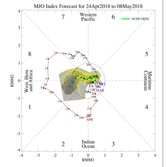
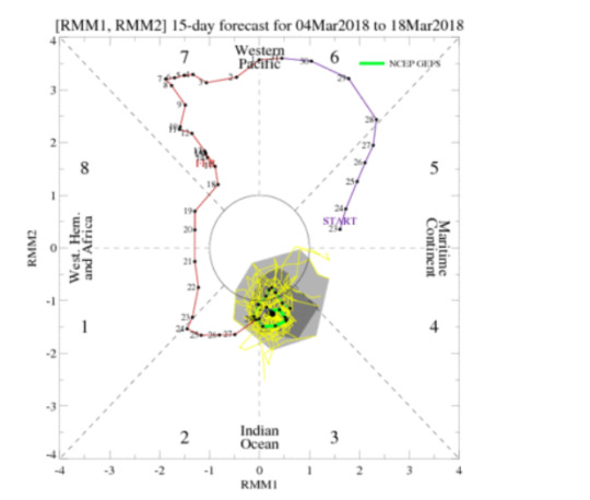
The MJO shows heavy influence within quadrants 8 and 1 and even starting to increase in the 8 range. This is indicative of a cooling of temperatures over the next several days which could lead to more severe weather patterns like normally seen when the MJO is showing dominantly in quadrants 7 and 8. Although, 8 is the area to be on the watch for with this coming system. The primary threats for the Chattanooga and surrounding areas are as of right now just heavy reainfall but the storms will need to be watched intentively as they develop southward.
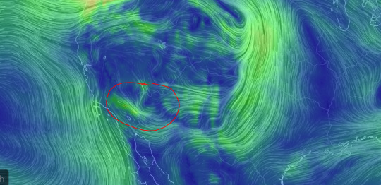
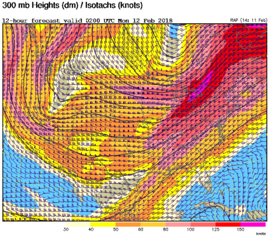
The model below, which is definitely someting, to note is theta-e ridging. As shown from the higher green and blue values on the map above, there is plenty of lifting mechanisms on Monday which will provide the path of all the precipitable water in the region. The areas which are in green are the regions with the highest potential of tornadic weather, but this is not determined by this theta-e ridge chart. This merely shows how the thermodynamics of the atmosphere are working to create a hill to climb for all our instability and moisture that is available. Areas which are falling from the south due to the flow of winds will be rushing towards the surface. There will likely be, at the very least, very strong local wind events occurring from this storm event.

From the two maps above we can see an intense ridge setting up to the west of the forecast region with high dewpoint values and strong influence of cool, Arctic air. As the cool, dry air intrudes rapidly, the chance for severe weather will become more prominent. This will be something to watch very closely within the next days as this could be the primary factor for severe wether development as the ridge propogates eastward. Humidity will be a primary driving force for the storms to come later this week as relative humidity is rapidly increasing in the overnight hours as much of the next day or two will consist of clear skies.
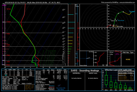
Model prediction to backup these findings are quite significant. As we see from the GFS sounding above, rainfall is almost eminent as the dew point rises after the Sunday and Monday of clear skies; this will be especially true because during the overnight hours skies will also be clear. SPC has placed the region just southwest of the forecasted area of Chattanooga. Though the area could see some early morning fog as the lower levels look quite saturated as we can see from the sounding above. This still would not put Chattanooga under some slight visibility issues, but does put the area closer to the more prone, upper mountaneous impact regions.
0 notes
Text
Mavericks, Half Moon Bay, California
With majority huge waves coming in during this time of year, transition seasons are perfect for catching some killer waves on the pacific coast. One particularly famous location where killer waves are something of a speciality is located in southern California’s Half Moon Bay. Discovered for its great surf only 20 or 30 years ago, the area has been one of the greatest surf locations in the United States. Some even compare the size of the waves to what you can find in Hawaii, which are some massive, over 40 feet, waves.

One reason for this intense wave population in the region is the steady convergence of winds during an onshore flow of winds. If you notice the Convergence of winds just under the High pressure symbol placed directly over Mavericks. This convergence of winds is highly due to the geography of the location. If you notice, the general shape of the coast leads winds to form into the pattern described. When these heavy onshore winds converge, massive waves can be created. This is also becasue waves are largely controlled by winds are not swells as most people might call them.

Currently, winds are generally parallel to the shoreline which is not the greatest scenario to develop large waves. This setup will change drastically, though, as the day goes on the surface flow will shift from being so parallel to the shore to a more direct inland flow. This is due to the differential heating of land and water. As the land warms much quicker than the water, high pressure forms over the land and draws in the cooler air out at sea. When we get this shift in winds is when the best waves will start to take shape all along the coast. Although, it will be sometime before we see our classic Mavericks waves.
The mean winds between the surface and 400mb can tell us a lot about the vertical winds and how strongly they are influencing the surface behavior. This is extremely important in predicting scenarios like whether it is a good day for surf or not. Looking at this chart it is clear that the mean winds are actually most concentrated over the discussed Mavericks region. This will be important later in the day once the onshore flow has picked up and gotten into a full swing of intensity.
Since the sun has not yet risen over the great surf state, In order to look at what is happening in the atmosphere with a satellite I have pulled some fantastic GOES-16 imagery to provide a longwave infrared view of just exactly what is going on at this second. Just over the Mavericks regions you see a decent amount of cloud cover and some of those clouds even having a decent amount of ice concentration indicated by the darker green colorings on the map. This is particularly good for large wave development, just not good for the addition of a human trying to surf them. Early this morning the waters may be a bit too choppy for a paddle out, but later in the day this will shift. Although I do not see today being a good day for a surf due to the baroclinicity of the area and very little surface winds being produced.

The most gnarly waves are most likely set to roll through the area on friday afternoon justa around 11am. The chart above shows an upper air image of that time exactly. What I notice about the half moon bay region is the almost perpendicular positioning of the winds to the shoreline. This is imperative for large wave development like what we generally see with Mavericks becasuse without heavy winds attacking the shore so directly, you cannot get this type of phenomena that the great American surfing world has coined as the Mavericks. I am personally very intrigued by surf and weather. The two play hand in hand, and even though I’m no surfer I am an atmospheric scientist. Wherever you are If you need a surf foreast just let me know! I’m always down to weather nerd.
0 notes
Text
Tsaile, AZ
The average winter pattern of mild and dry conditions and now flipped. Cooler temperatures and unstable weather is making its way to the Mogollon Rim and Chuska Moutains. High temperatures today will be in the mid 50s and quickly drop into the upper teens. Rain chances will increase into the evening as a low pressure system, accompanied by a cold front moves through the northeast portion of the state and parks itself near the four corners. The passing of the cold front will lower temperatures into the upper teens and low 20s overnight.
It is likely that rain will change over to snow as temperatures drop below freezing by midnight at some higher elevations. Rain accumluations will be between a half and up to an inch. Sounding data supports a cooling profile and significant moisture available in the snow growth region. Another chance for snowfall might come again later in the week, but is looking to remain fairly low as temperatures are on the rise for the next several days.
The NAM and GFS models seem to be disagree on the strength and particular timing of the system. NAM shows the system lift and moving off to the northeast faster than GFS. Contrasting, GFS shows the trough digger further south and staying longer. GFS supports greater positive shear vorticity and closer height contours 00z Sunday and 12z Sunday. NAM on the other hand supports a more baroclinic flow with the system. GFS seems to be overall handing the timing and strength better the the NAM.

This system is also bringing in some gusty winds ahead of the front. A Wind advisory stays in effect until Sunday morning. Today winds will be from the southwest at 20 to 30 mph and gusting as high as 40mph at greater elevations. Relative humidity values also remain low during this time in the lower teens and single digits. The combination of fast winds and dry air is enhancing fire risks. Luckily, winds slowly diminish moving into Sunday as more moisture gets added to the atmosphere and clouds clear out.
Sunday will be mostly clear and sunny with the presence of high pressure.Temps only climb into the low 70s with slightly higher winds coming from the northeast at 10 to 15 mph. The atmosphere remains fairly unsettled and a deep trough is beginning to set up on the western half of the united States. The first shortwave system exits by Sunday evening, but this shortwave is part of a much stronger low. The low as it backs off the West will eventually occlude between the California and Nevada border. This positioning will allow for energy to feed into Arizona. Low temperatures Sunday night will be slightly warmer then Saturday night reaching the mid 50s. Winds have also shifted to the southwest at 5 to 10mph which will amplify moisture levels for Monday.
0 notes
Text
Branson, MO
Temperatures for this afternoon through tonight should be within two or three degrees of what they have been the past few days. These temps will persist until Sunday morning when a trough will move over the area and bring more northerly flow of winds, and more seasonal temperatures. The primary focus of today is the current system which is affecting the area. High winds are expected throughout the day as well as higher chance for severe weather. To get a better idea of exactly how the current system moving over will affect the region, let’s analyze some charts.
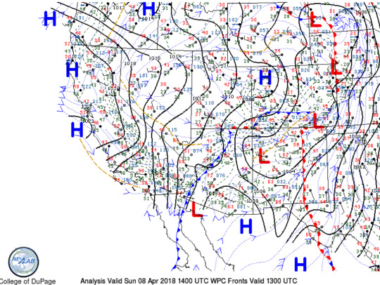
Right away something to note on this 500mb chart is the city’s proximity to the trough. This proximity is the height of the development zone. With the proper amount of moisture and uplift within the region it is guaranteed there is storm development ahead of this trough being pushed out. Moisture is not plotted on this chart and uplift certainly is not either. Cross-sectional analysis will give a perfect picture of just how the column of air concerning the Branson area is acting.
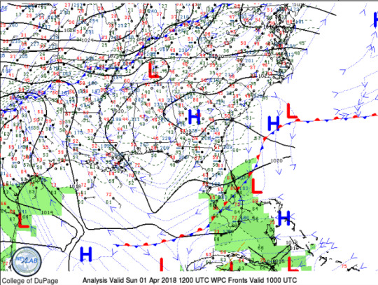
Just as was inferred from cross-sectional analysis, thanks to the College of DuPage, there is a clear low tracking over the region as well as plenty of uplift behind it. These combined with the forcing of upper air winds should deliver some fairly solid showers to the Branson region.these showers have a good chance of falling into the overnight hours into the next morning. Although long-lived, there is not any severe weather expected from this line of convective storms.
Specific times for rainfall begin at just around 9:35, but really pick-up here at eleven a.m. with much greater chances for decreased visibility at the surface. While visibility aloft will be quite open, so pilots you should have a good flying day given the near surface winds ease up (KAVU). The biggest worry for Branson at this time are winds affecting the area. There are heavy winds with current storm conditions and these are only expected to increase and the day goes on. The national weather service has the city under wind advisory until 5 p.m. today.

With the system passing today, temperatures will drop 15-20deg Fahrenheit and then continue to be cooler and more season as more northern synoptic flow will impact the region. Looking ahead to Sunday afternoon, the high will be somewhere around 48deg and a low of around or below freezing. This will then be the trend for the next couple of following days as shown above from the high temperatures map.

0 notes
Text
Southeast US
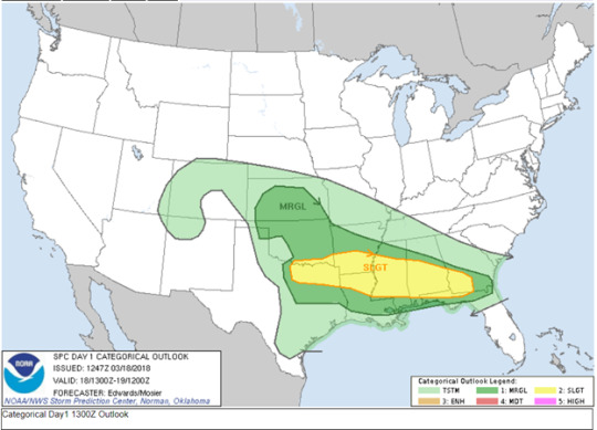
Much of the southeast United States is expecting chances for severe weather, especially the eastern Alabama areas as we will see from the model outputs ahead. One primary factor taking place which is like a primer for an outbreak scenario is the extreme amount of mixing over the region. The past few days of warm, moist conditions combined with a cooler atmospheric temperature for today could potentially be the mixing needed for heavy storm development. The hours of 18z to 6z on Monday are the times with the greatest potential of severe storm development. As with many tornado scenarios in the southeast, this is expected to be a nocturnal event.
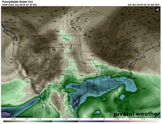
As previously mentioned, there has been a large amount of mixing within the past several days. Flow from the gulf has provided more than enough moisture. This can be seen in the map above valid at 6z today. This map shows the precipitable water available to the atmosphere. With some frontal expression within the coming 24 hours, much of this precipitable water should fall with some haste. Areas like Louisiana and southwest Mississippi will probably see the highest rainfall values, but not the worst storms.

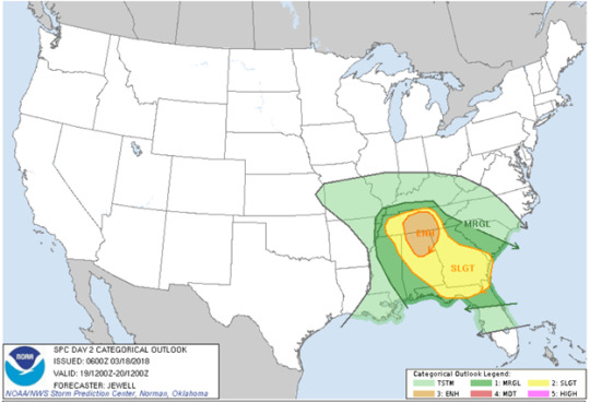
From today into tomorrow the chances for more severe weather increases over the northern Alabama and Central Tennessee regions. As the nor’easter begins to lift out, its intensity will increase as the rotation begins to intensify due to greater helicity. Day 2 should be watched closely as the time draws nearer as to avoid any surprises for an evening. Precautions should be taken, regardless of whether an actual tornado is reported there is still a chance for a great amount of damage to be created from these strong cells which will form. The potential for hail is always prevalent for this type of setup, and with the atmospheric temperature being a bit lower on the day, we could see rapid hail development given the proper updrafts/downdrafts are in place.

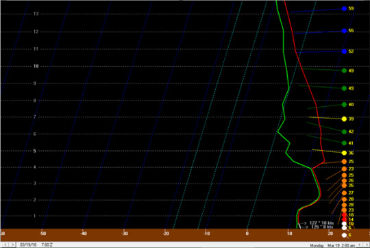
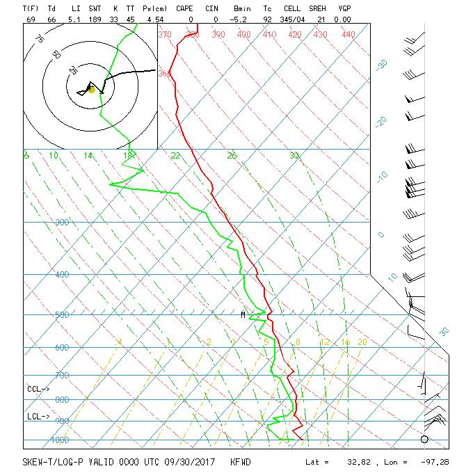
The sounding above is from Birmingham and is valid Monday, March 19 for 7z and is the precursor to a decent amount of rainfall. At this point the QPF would be around 1in but those values are usually almost negligible due to inconsistencies. What this sounding does show is a classic, field goal style sounding which is indicative of tornado development. What is also important to note from this sounding is the direction of winds. The shifting of 180 degrees between the surface winds and the winds aloft can create the gradient necessary to form a rotating column of air.
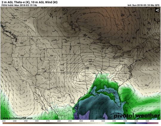
The last and final model to note is theta-e ridging. As shown from the higher green and blue values on the map above, there is plenty of lifting mechanisms on Monday which will provide the path of all the precipitable water in the region. The areas which are in green are the regions with the highest potential of tornadic weather, but this is not determined by this theta-e ridge chart. This merely shows how the thermodynamics of the atmosphere are working to create a hill to climb for all our instability and moisture that is available. Areas which are falling from the south due to the flow of winds will be rushing towards the surface. There will likely be, at the very least, very strong local wind events occurring from this storm event.
0 notes
Text
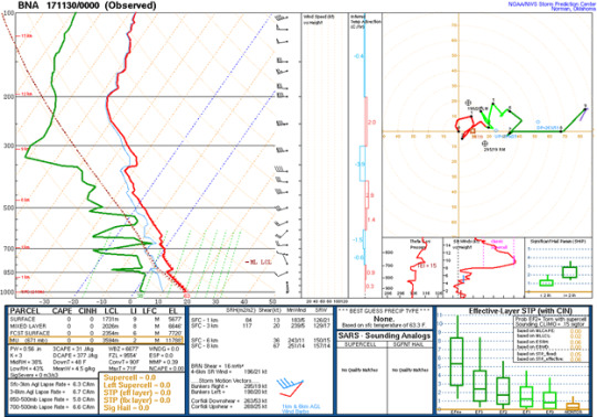
Southeast Severe Outlook/Birmingham
Much of the southeast United States is expecting chances for severe weather, especially the eastern Alabama areas as we will see from the model outputs ahead. One primary factor taking place which is like a primer for an outbreak scenario is the extreme amount of mixing over the region. The past few days of warm, moist conditions combined with a cooler atmospheric temperature for today could potentially be the mixing needed for heavy storm development. The hours of 18z to 6z on Monday are the times with the greatest potential of severe storm development. As with many tornado scenarios in the southeast, this is expected to be a nocturnal event.

As previously mentioned, there has been a large amount of mixing within the past several days. Flow from the gulf has provided more than enough moisture. This can be seen in the map above valid at 6z today. This map shows the precipitable water available to the atmosphere. With some frontal expression within the coming 24 hours, much of this precipitable water should fall with some haste. Areas like Louisiana and southwest Mississippi will probably see the highest rainfall values, but not the worst storms.
From today into tomorrow the chances for more severe weather increases over the northern Alabama and Central Tennessee regions. As the nor’easter begins to lift out, its intensity will increase as the rotation begins to intensify due to greater helicity. Day 2 should be watched closely as the time draws nearer as to avoid any surprises for an evening. Precautions should be taken, regardless of whether an actual tornado is reported there is still a chance for a great amount of damage to be created from these strong cells which will form. The potential for hail is always prevalent for this type of setup, and with the atmospheric temperature being a bit lower on the day, we could see rapid hail development given the proper updrafts/downdrafts are in place.
The sounding above is from Birmingham and is valid Monday, March 19 for 7z and is the precursor to a decent amount of rainfall. At this point the QPF would be around 1in but those values are usually almost negligible due to inconsistencies. What this sounding does show is a classic, field goal style sounding which is indicative of tornado development. What is also important to note from this sounding is the direction of winds. The shifting of 180 degrees between the surface winds and the winds aloft can create the gradient necessary to form a rotating column of air.
The last and final model to note is theta-e ridging. As shown from the higher green and blue values on the map above, there is plenty of lifting mechanisms on Monday which will provide the path of all the precipitable water in the region. The areas which are in green are the regions with the highest potential of tornadic weather, but this is not determined by this theta-e ridge chart. This merely shows how the thermodynamics of the atmosphere are working to create a hill to climb for all our instability and moisture that is available. Areas which are falling from the south due to the flow of winds will be rushing towards the surface. There will likely be, at the very least, very strong local wind events occurring from this storm event.
0 notes
Text
Jackson, MS
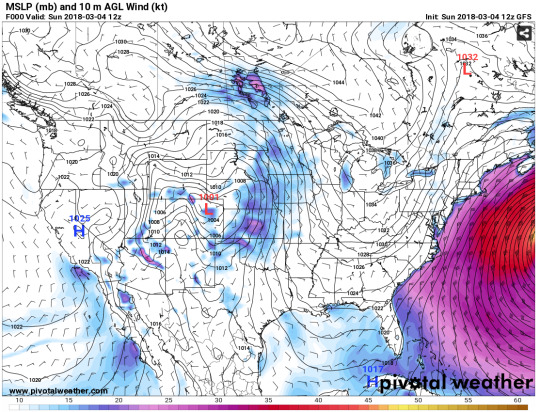
Throughout today into this evening, and even into the overnight hours, there is a chance for isolated severe weather for the Jackson, MS area. Much of this risk is due to the shift of winds winds is occuring almost directly over the region. Noticing from the GFS model below which is valid 12z today, there is a clear strong gradient forming over most of the dixie alley. This apparent “fold” in the gradient will provide the potential for more likely rotation than a normal geostrophic, surface setup might. The Primary factor to look at here is the location of the low. It will be moving quite rapidly and if it tracks a little further south as predicted, the chances for sever weather beome greater.

Comparing the GFS with the NAM, it is clear that the NAM is spotting the low much further west of the Jackson region than the GFS model. This would mean that the severe weather possibility would come later in the day if this model holds true. Another big factor to look at with the NAM is the stronger gradient of winds located just to the north of Jackson in the Northern portion of Tennessee. If this is the gradient of winds that sets up today, helicity values will be much higher and should start watching storm development closely along with vorticity values.

The sounding from this morning has very little preciptiation showing. There are an hour or two where the temperature and the dewpoint line up ever so slightly so there could be several pop up rain showers around the area. These pop up storms will have the potential of developing into much stronger cells as the vertical wind gradient is quite shifty for the majority of the day. While no torential downpour is expected. I would say around 30% chance of rain for the day. This of course meaning that not all areas will receive rainfall on today, but the areas that do should expect less than an inch of accumulation.
I chose to look a bit later in the day when the low moves a bit more to the east. This is when the Jackson area could start to experience some frontal weather. Much of the jackson area will be under a close watch for flooding and flash flooding, especially the vicksburg area should be aware of the waterways and be mindful of which are accessible if any are to be closed. Another thing to point out from this map is the concentration of gullf winds approaching almost directly from the south. This Moisture content will provide more than enough for some big storm development.
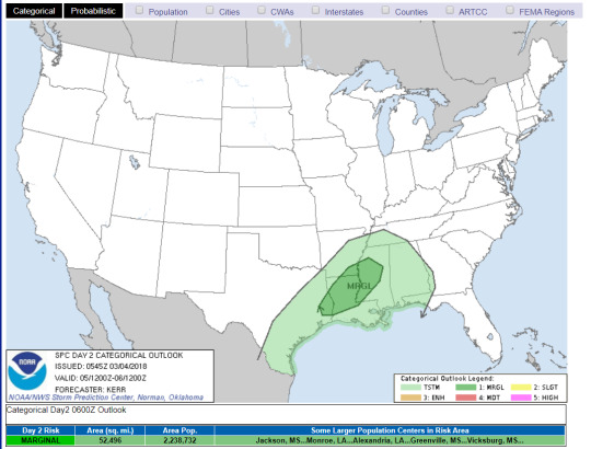
A slight risk has been placed just to the north of the jackson area leaving much of the region under a marginal risk. With this risk comes the potential for severe strom development. With the way the GFS has been predicting over the past several days, I would argue that is is better varified. With that in mind I think the slight risk area should be a bit more south, but still not effecting the Jackson area. This would only mean heavier winds and a greater chance for severe weather today.
0 notes
Text
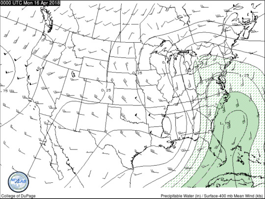
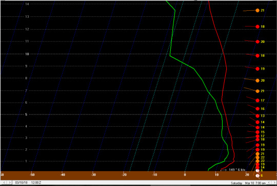
Chattanooga, TN
During the cooling off that is to come within the next several days, along with it will be thunderstorms and the increasing chance of severe weather possibility. Much of the Chattanooga area could experience drastic rainfall totals from monday evening until the later hours on wednesday. The greatest potential for severe weather will come sometime on wednesday, possibly mid-to-late afternoon.
The MJO shows heavy influence within quadrants 6 and 7 and even starting to increase in the 8 range. This is indicative of a cooling of temperatures over the next several days which could lead to more severe weather patterns like normally seen when the MJO is showing dominantly in quadrants 7 and 8. Although, 8 is the area to be on the watch for with this coming system. The primary threats for the Chattanooga and surrounding areas are as of right now just heavy reainfall but the storms will need to be watched intentively as they develop southward.
From the two maps above we can see an intense ridge setting up to the west of the forecast region with high dewpoint values and strong influence of cool, Arctic air. As the cool, dry air intrudes rapidly, the chance for severe weather will become more prominent. This will be something to watch very closely within the next days as this could be the primary factor for severe wether development as the ridge propogates eastward. Humidity will be a primary driving force for the storms to come later this week as relative humidity is rapidly increasing in the overnight hours as much of the next day or two will consist of clear skies.

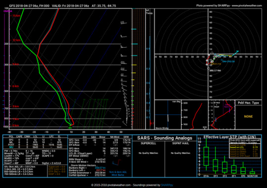
Model prediction to backup these findings are quite significant. As we see from the GFS sounding above, rainfall is almost eminent as the dew point rises after the Sunday and Monday of clear skies; this will be especially true because during the overnight hours skies will also be clear. SPC has placed the region just southwest of the forecasted area of Chattanooga. I believe the MRGL region should actually be a bit more East than shown on the SPC due to upper level steering. This still would not put Chattanooga under marginal risk but does put the area closer to the higher impact regions.
0 notes
Text
Corinth, MS
Much of the area was hit qutie heavily during the overnight hours from the frontal system that really started impacting the area just around eight o’clock Saturday night. This storm system has continued to provide the region with rainfall up until now and can be expected to continue up until late to mid-morning. The primary threats associated with high QPF values for Corinth is flooding. Much of the roadsystems and tributaries are highly succeptable to flooding at residents should be weary of roads which are low-lying and/or gravel roads which are prone to quick erosion.
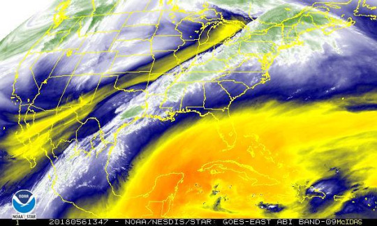
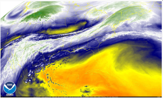
Current water vapor values show much more in the northern region. with the dry line placed just the the east, much of the rain is building in behind this area as shown by the green values on the image from GOES-16. Keep in mind this is water vapor not current rain values. Therefore much of these areas under the slightly green values have the potentail for rainfall. Much of what is indicated is little showers which should be moving out by tonight.

Looking ahead to the mid-to-late afternoon, temperatures will rise ever so slightly once the rain subsides. Then, expect skies to clear up into the overnight hours with no chances of rain leading into monday and tuesday. Other than a bit of cloud cover, not much will be in the forecast as far as thunderstorms until Wednesday. Wednseday expect nothing less than an inch of rain.
Little to no cape values shown for on the Monday sounding at 00z. The primary thing to look at here is cloud development. As this is in the later hours, it will provide a nocturnal radiative cooling event overnight and keep temperatures right around the same as the area experienced today. Monday’s high will be in the upper 60′s while tuesday there will be a warm up and temperatures will shoot back up to the 71-73 range.
The next threat that might have some heavy impact on the Alcorn county region is the next wave of storms that will be coming through late Tuesday to early Wednesday morning. This stationary front will set up just to the west of the MS delta and then begin to deliver heavy storm development and greater potential for severe weather. As shown in the graphic below, SPC has already placed the region under a marginal threat.
0 notes
Text
Austin, TX

For the majority of the winter, much of the greater Texas area has experienced much cooler temperatures than in previous years. Along with these cooler temperatures has come some pretty nasty stroms over the previous four to five months. Yet again, much of the eastern Texas area will be affected by scattered showers for the remainder of today and tomorrow a front will begin in the cumulus stage just north of the Austin greater area. From the grafic below, you will be able to see the beggining stages of this front occuring off to the west of the region while there is some cold air advection affecting the area now.
This is the 7pm sounding for monday from the GFS model. most of the models are generally showing the same thing but something important to notice is just how much the low will dig southerly. The more flow that can be generated from the northwest direction will heavily influence the intensity of the system. Granted, in this case there are no extreme threats at this time but will look to this in the future. Will have to know closer to when the fronts are fully developed.
This is the NAM valid for the same time slot as the product from the GFS above. The primary differences between the two model outputs in the short range is the high pressure off to the east which is causing a backing up of winds in the midwest. The NAM shows this high being quite stubborn and sticking around much longer in the coming 24hr period than the GFS. One primary factor to note is that the more backing up occurs, the heavier the storm systems will be.
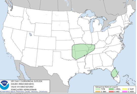
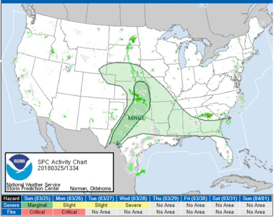
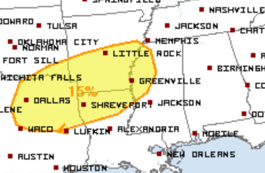
Still the most important days that will be needing a close watch are tuesday and wednesday. The threat level assigned from the national weather service is that of a marginal risk factor. This means that much of the time spent storming will be relatively calm compared to some of the previous storms austin has encountered this year already. One thing that might be the most important to look out for during this event is flash flooding.
SPC shows most all of NE Texas encompassed in this marginal threat area. It is important to remember that just because much of the area is within a marginal risk that features of which accompany a slight risk could still occur. the possibility for a supercell convective system is always in play, especially for this area of the country during a time when a lot of warming has just taken place. The result from this warming could lead to much higher cape values and therefore give the storms greater convective potential.
0 notes
Text
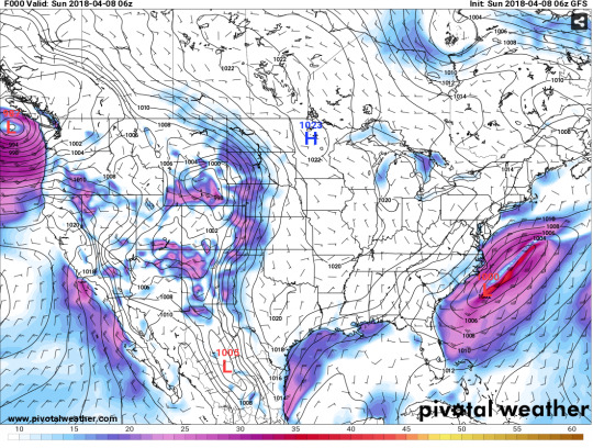
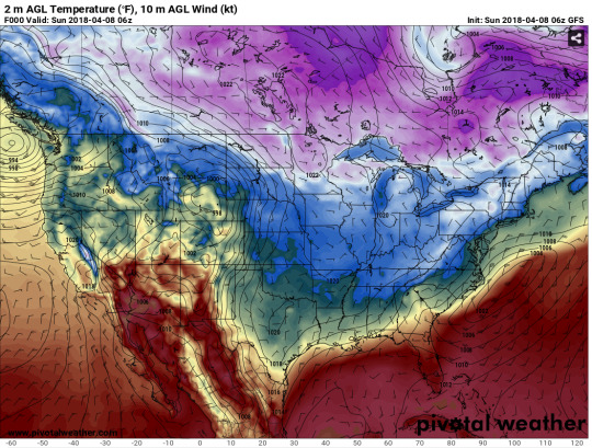
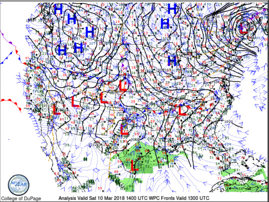
St. Louis, MO
A quick overview from SPC shows that most of the weather systems have propogated eastward from the St. Louis region. Apart from a cooling of temperatures, especially during the early morning hours, There is not any expected rainfall for the region within the next 24 hours. The Primary threats that should still be taken into consideration is surface ice. From rainfall accumulations and surface temperatures well below freezing, the chances for hazardous bridges and potential threat in low lying regions of roadways.

While the majority of the rainfall is out from this morning, temperatures will continue to be lower than average going forward. This is the 24-hour GFS temperature guidance and from what I can see, I would guess there is a trough possibly starting to move out from the looks of the temperature distribution. After analyzing upper level charts I will be able to give a better answer to whether the trough is in positive or negative tilt, but this is likely to be the pattern for the coming days.
As predicted, upper level wind are shooting down from Canada and then being driven eastward, causing this trend of low temperatures. Also as predicted, the trough is positioned in a negative tilt. Meaning that temperatures could drop even more within the next 2-3 days. I’ll be anxious to see just how this upper level flow progresses. For the St. Louis region, how far this trough digs in will truly be the deciding factor for high/low temps.
From a true look at upper level winds, it is clear that there is not much backing to the east of the US. Because of this, the trough currently lying over the St. Louis area will have plenty of space to occupy and therefore move out. Oppositely, after a few days of warmer temperatures, there is a deep digging trough to the west which is currently effecting Japan. It is likely this is the pattern which we will see here in the US in the coming days. In the long range, I would expect another cold shot of temperatures that will be even cooler than what we are seeing now.

Band-10 on the GOES-16 satellite shows lots of moisture signature just on the southern portion of the state. Looking at the St. Louis region there is a decent amount of cloud cover and even some heavier signatures if not right over St. Louis, then just across the state line into Illinois. This is the area releasing that bit of freezing drizzile which was seen in the early hours up until around 10am. For the remainder of the day there should be little to no precipitation though as clouds continue to propogate NE it will be a mostly cloudy day for St. Louis.
0 notes
Text
Mississippi is Heating Up
The past few weeks of winter have definitely been just that. Bitter cold days and nights along with some moisture provided a white winter for the Northern portion of the state. Although this is well behind us. Today in Corinth the high was 53 and tonights low is much warmer than last nights only bottoming out at a brisk 46degF with a small breeze between 5-8mph. This is what can be expected for the coming days.

The chart above is valid Monday 6am. Morning temperatures, for the majority of North MS, will be around 55 accompanied by a small chance of showers. This rapid warming is a whole 20 degrees warmer than the previous recorded morning temperatures for the Alcorn county region. Most likely, this will be the trend for the coming days with the exception that the comind days will be slightly cooler due to a spout of dropping night time temps.
The formentioned spout of rain expected in the morning will likely, if at all, impact the area at around 7am shown in the chart above. The mid-latitude cyclone has been weakening as it has began to occlude. Though that does not mean there is no chance for it to sustain unitl leaving its mark on MS. Due to the shift of southerly winds, I expect there will be enough moisture in the region.

The system will completely leave the region by late monday/early tuesaday and leave North MS with a few nights of much cooler temperatures. This shift in winds which are having an effect on the region is the main reason for this cooling off. As the chilly arctic air rushes from the north behind this system, we can expect weather to seem a bit more seasonal.

As mentioned before, temperatures will dip back into the mid to low 40s tuesday afternoon as a result of the backwashing, so to speak, from the system. By backwashing what I’m referring to is the northern air which is continuously being pushed southward from the western portion of the anti-cyclonic flow. Along with the cooler temperatures, the region can expect to see a slight rise in wind speeds. So, along with temperatures on the fall, the wind will provide some very winter-like conditions.
*LATER THIS WEEK*
The remainder of the week will be sunny through Friday evening and then another chance of scattered showers will come again next weekend. The primary focus for wednesday through Friday is the return of much cooler night time temperatures. Winters like this are quite common for MS as most of the northern portion will warm quite quickly during the day, but continue to have bitter cold nights. There is a forecasted chance of rain for next weekend, but SPC day 7 convective is not currently showing anything. It is a whole week away so how much does that really mean, well not much. So this will be something to watch leading up to next weekend.
0 notes
Text
Loan Oak, KY
Clear skies are expected for the next several days, aside from the occasional cumulus cloud cover later in the week on Friday and Saturday. This will be especially true for the evening hours. While no thunderstorm activity will occur within the near future, night time temperatures continue to sit just below freezing. This will be the case through Saturday when the lows are looking to be on the rise.

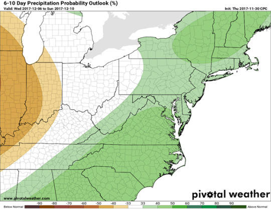
While the sounding does show some indication of possible cloud formation early in the day, this has well been on its way out. This is a very quiet sounding with not much to indicate any threats on the day. Aside from such massive deviations within the dewpoint, this will be the look of the morning soundings for the next week. There is some possible rain for the region within the next 6-10 days as shown below in the 6-10 day CPC, for what that is worth.
Ridging will move out and by Saturday a small trough will move over Kentucky and add to those chances of precipitation. But the area to look at on the chart below is to the west. Although the trough is not digging very deep and almost in a zonal flow, it has great potential for development. From the 6-10 day CPC, this will be the provider of surface accumulation.
Mostly a peaceful beginning to December as temperatures remain slightly chilly during the day. Sunday will be the day to pay attention to your weather app for chances of rain. A high off the Appalachian will give good lift to the Loan Oak and surrounding areas and let loose a decent amount of precipitation. The time for departure of the rain event is sometime early to late Tuesday. There are some discrepancies between some of the models with the movement of synoptic scale features. The when of this question will be answered when the event is not so far out and more pressing data is available.
0 notes
Text
Branson, MO
Temperatures for this afternoon through tonight should be within two or three degrees of what they have been the past few days. These temps will persist until Sunday morning when a trough will move over the area and bring more northerly flow of winds, and more seasonal temperatures. The primary focus of today is the current system which is affecting the area. High winds are expected throughout the day as well as higher chance for severe weather. To get a better idea of exactly how the current system moving over will affect the region, let’s analyze some charts.

Right away something to note on this 500mb chart is the city’s proximity to the trough. This proximity is the height of the development zone. With the proper amount of moisture and uplift within the region it is guaranteed there is storm development ahead of this trough being pushed out. Moisture is not plotted on this chart and uplift certainly is not either. Cross-sectional analysis will give a perfect picture of just how the column of air concerning the Branson area is acting.
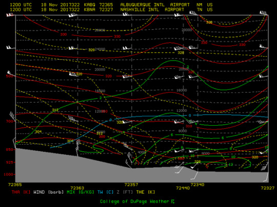
Just as was inferred from cross-sectional analysis, thanks to the College of DuPage, there is a clear low tracking over the region as well as plenty of uplift behind it. These combined with the forcing of upper air winds should deliver some fairly solid showers to the Branson region.
Specific times for rainfall begin at just around 9:35, but really pick-up here at eleven a.m. with much greater chances for decreased visibility at the surface. While visibility aloft will be quite open, so pilots you should have a good flying day given the near surface winds ease up (KAVU). The biggest worry for Branson at this time are winds affecting the area. There are heavy winds with current storm conditions and these are only expected to increase and the day goes on. The national weather service has the city under wind advisory until 5 p.m. today.

With the system passing today, temperatures will drop 15-20deg Fahrenheit and then continue to be cooler and more season as more northern synoptic flow will impact the region. Looking ahead to Sunday afternoon, the high will be somewhere around 48deg and a low of around or below freezing. This will then be the trend for the next couple of following days as shown above from the high temperatures map.
0 notes
Text
Starkville, MS
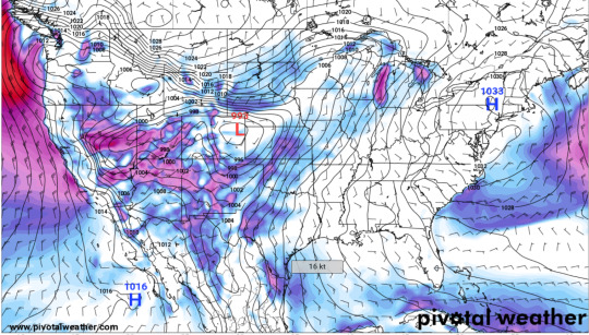
After several months of convective thunder storms and rain showers effecting most of the southeast region, now a Low forming to the south in the gulf brings Starkville and the surrounding areas several days of possible precipitation. These chances for rain will persist from later this week on saturday until possibly the following wednesday morning. Current upper air maps show the system which will be effecting our region in a few days just to the southwest. As the ridge over the system begins to propogate eastward the surface Low will be steered by this motion and the potential for Hurricane formation is immenint.

As mentioned in the paragraph above, we see in this image a tightening gradient just off to the west of texas which is a strong indicator of rising motion and anti-cyclonic rotation. If we look a few days ahead, we begin to see this very same setup over Arizona move over Arkansas and Louisiana. As this occurs the south-westerly flow of winds will carry the moist, gulf air into this highly convective system and we will likely have a decent amount of rainfall with this event.

From the previous image, which shows theta e values in kelvin, there is an obvious amount of convective components just to the east of the current formation location of the storm. This particular setup is very inviting to a system of this extent bacuse it provides the perfect heat source to drive the storm.
The next image is meant to be compared with the previous one. Detailing the extent of the components for which this system will be making use of in order to reach its potential. Along with the load of convective properties, the temperatures of this region are also suitable as much of the gulf still has lingering energy, entropy, left to use up. Along with this energy left over, differential heating of land and surface is also apparent. This could potentially be an enabler in the development of this storm.

Finally, the National Hurricane Center shows a likely less than 40% chance for hurricane/disturbance development within the next two days. I believe that we will see this likelihood be inceased within the next coming days as the development of this storm begins to unravel. While we are looking for development regions, the depression whichs lies to the south should be kept up with a watchful eye. A the ridging sets up to the north, chances for this depression to up in significance will increase.
0 notes
Text
Austin, TX
More warm to moderate temperatures for Austin, TX for the next couple of days as continental flow from Northern Mexico directs to most of the state. The trough to the east will continue to provide an exit region favorable to this continental flow of warm, dry air and the daily/nightly highs and lows will show from this setup.

There is a potential for some relief to these warm temps looking ahead at the 48hr forecast there is moisture just to the south of the region. As the trough to the east continues to provide a suitable exit region for the flow of south-westerly winds, chances for some precipitation mid-day Tuesday and some of Wednesday are certainly expected to occur at the very least, locally. This will give way to a shadowing high pressure system and Austin can expect beautiful, clear skies through the weekend. The following week will hopefully present some much more seasonable fall like temperatures, especially for the daily lows.

As for the specifics of today, very clear skies excluding the occasional fair weather cumulis. High temperatures for today are 85-88, which a bit higher than the average of 82 degrees farenheit for this time of year. No local chances of rain in the region as there is currently not much instability to speak of, and even if there were the moisture that it needs hasn’t joined the party yet. The souding for the region indicated a dew/fog free morning and nothing close to mixing. In-fact, the cape value for today is a big fat zero.
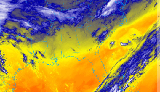
As mentioned, and visually shown here by GOES16 visible imagery, there is little to no moisture over most of the state of Texas; this is especially true for the Austin area which is in the circle of dry air over east Texas. This image will of course look very different by monday night there will start to be much thicker billowing to the south in Northern Mexico and then by Tusday afternoon we will see that cloud cover slide over east texas and that moisture will precipitate once reaching the heavily favorable environment that will be directly hovering over Austin.
0 notes
Text
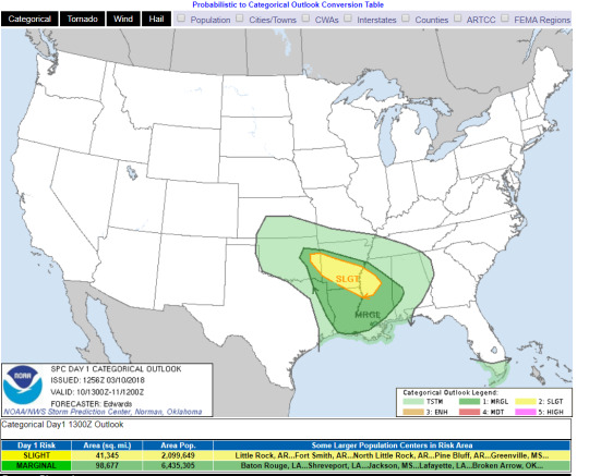
Little Rock, AR
TODAYSAT 09/16HIGH 89 F
0% Precip. / 0.00 in
Mostly Sunny. High 89F. Winds SSE at 5 to 10 mph.
TONIGHTSAT 09/16LOW 69 F
10% Precip. / 0.00 in
Mostly Clear. Low 69F. Winds SSE at 5 to 10 mph.
TOMORROWSUN 09/17HIGH 89 | 69 F
10% Precip. / 0.00 in
Mostly Sunny. High 89F. Winds SE at 5 to 10 mph.
Expecting average summer temperatures for most of the afternoon in central Little Rock. Moving into tonight temperatures are expected to make a steady decline to somewhere between 67F and 70F. Some forecasts are showing a 10% chance of precipitation today, but the trough to the west will not make contact with the region until late Monday evening to Tuesday morning. This primarily due to the positive position of the trough which will dig well into the region due to upper level winds.
- This model valid at 24 hours and the ridge is shown to still be well off to the west from Little Rock. The ten percent chance of rain that is expected tonight will be no more than sporadic summer pop-up showers.
Looking 24hr ahead...

- This current NCEP model valid Monday morning shows the trough still hanging just north of Little Rock. Expect deeper digging from the trough and more of a direct contact with the area of highest convergence with the Low now hanging over Oklahoma.
The Low will move through upper level forcing, and looking at 500mb winds we see the main center of Low in canada in a highly positive position. The postion of the trough can depict how the trough, in this case, will dig SE until being lifted out later in the week.
Later in the week, chances of rain continue to impact the central Little Rock area. Until late Tuesday afternoon about 20-30% chance of rain, and this chance of rain will continue throughout the week. Temperatures will also remain average during day time hours, but a steady decline of night time temps until the weekend ranging from 70-58F.
0 notes