
Last Seen Blogs

arcydonia
now playing - new cydonia

lumiere-ito
Lumière clothing & leather item

rodentcompetition
little creatures


mrmorgan-mrjames
Colin Morgan & Bradley James, NEWS.
Photo
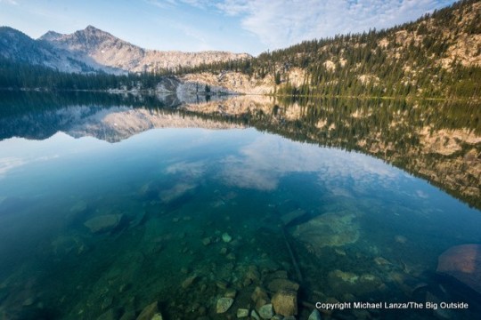
By Michael Lanza
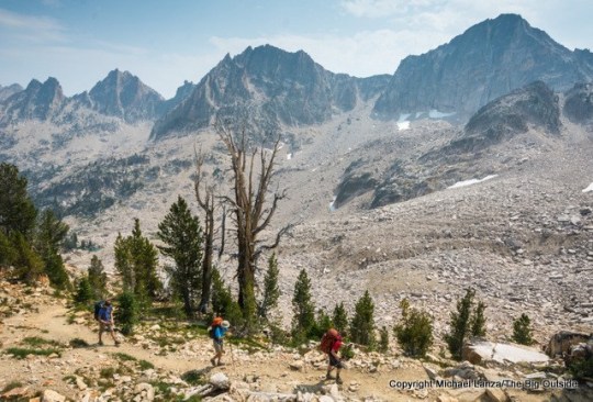
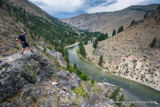
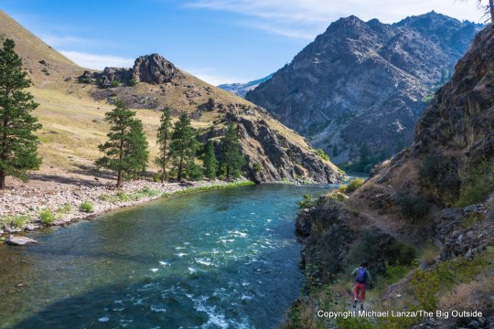
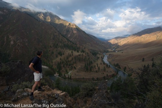
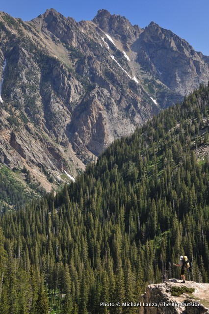
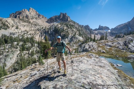
We emerge from our tents on a mild August morning to discover that the waters of the upper and middle Cramer Lakes, in Idaho’s Sawtooth Mountains, have transformed overnight. Where last evening these lakes on either side of our campsite had been rippled by mountain breezes, now they lie perfectly still; they are glassy mirrors offering inverted, sharp reflections of the forest and jagged peaks surrounding the lakes. A few hours later, our backpacking party of three parents and six teenagers hikes across wildflower meadows and past alpine tarns to proudly reach a mountain pass at over 9,000 feet on the Cramer Divide, overlooking a turbulent sea of razor peaks stretching to every horizon.
It’s an inspiring panorama. But to me, there’s more to this pass than the view: We also happen to be standing at one of the highest points along the most remote and wild long-distance trail in the Lower 48—and the newest. And thanks to the help of some conservation leaders in Idaho, this trail has, metaphorically speaking, come a long way from a notion in my mind to fruition.
A few years ago, I brought an idea to my good friend, Justin Hayes, then the program director of the Idaho Conservation League and now ICL’s executive director. I told him that Idaho deserves to have a long-distance backpacking trail that traverses its three signature federal wilderness areas.

My son, Nate, and two friends backpacking to Cramer Divide in Idaho’s Sawtooth Mountains.
From north to south, they are the 1.3-million acre Selway-Bitterroot Wilderness, which by itself is larger than many national parks, including Yosemite, Grand Canyon, and Glacier; the nearly 2.4-million-acre Frank Church-River of No Return Wilderness (aka “the Frank”), largest in the Lower 48 and bigger than Yellowstone; and the 217,000-acre Sawtooth Wilderness, protected as a primitive area since 1937, among the first places protected in The Wilderness Act of 1964, and now Idaho’s best-known and most beloved mountain range for its jagged peaks and hundreds of alpine lakes.
Taken together, these three very special places comprise nearly four million acres of almost-contiguous wilderness, a vast realm of mountains and canyons divided by just one rural highway (ID 21 outside the small town of Stanley) and two remote dirt roads. If these three wildernesses were contained within one national park, it would be America’s third-largest and the biggest outside Alaska.
I already had a name for this new footpath when I approached Justin and ICL: the Idaho Wilderness Trail. Not only do I like how it sounds, but that name speaks volumes about the quality of the backpacking experience the trail delivers.
Hi, I’m Michael Lanza, creator of The Big Outside, which has made several top outdoors blog lists. Click here to sign up for my FREE email newsletter. Join The Big Outside to get full access to all of my blog’s stories. Click here to learn how I can help you plan your next trip. Please follow my adventures on Facebook, Twitter, Instagram, and Youtube.
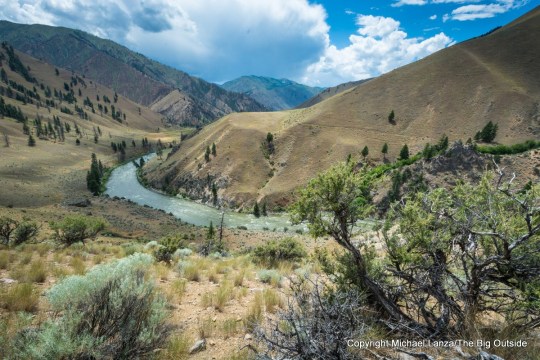
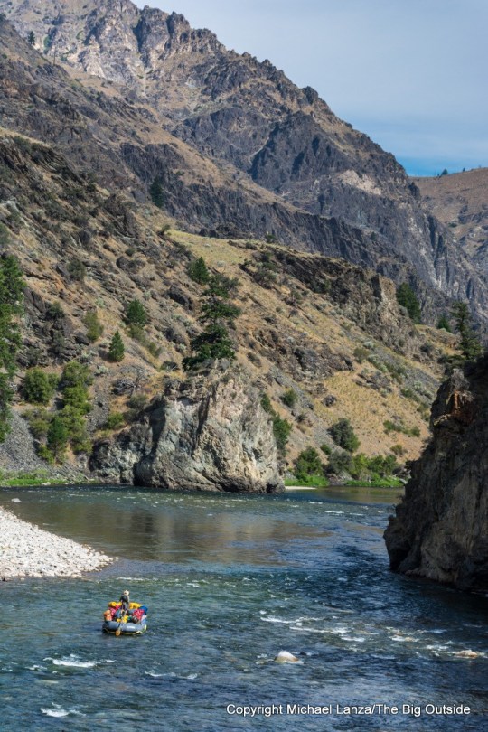
Linking up existing trails (requiring no new trail construction), the Idaho Wilderness Trail (IWT) crosses mountain passes over 9,000 feet and threads its way past peaks rising over 10,000 feet; follows three designated wild and scenic rivers, the Middle Fork of the Salmon, Main Salmon, and the Selway; traces the shores of innumerable alpine lakes; and meanders below dramatic spires from the Bighorn Crags in the Frank to the Selway Crags and the Sawtooths.
It traverses pristine backcountry that is home to mountain goats and bighorn sheep, elk and moose, black bears, hundreds of wolves (a population estimated to be at least seven times as many as live in Yellowstone), and abundant trout—and which offers some of the nation’s best remaining habitat in the Lower 48 for restoring a viable population of wild salmon.
Perhaps most uniquely, the IWT offers the kind of solitude you simply cannot find on most long-distance trails. In fact, many backpackers have never even heard of the wilderness areas the trail traverses.
Imagine that: Discovering a new long-distance trail that’s not just one of the best in America, but has been hiding in plain sight.
Now it’s ready to be explored by backpackers.
Like what you’re reading? Sign up now for my FREE email newsletter!


Birth of a New Long Trail
Having backpacked through much of the Sawtooths and parts of the Frank and Selway-Bitterroot over the course of living in Idaho for 20 years—as well as many of the very best backpacking trips the country—I knew that a north-south trail linking those wildernesses would constitute one of the most spectacular, diverse, challenging, and lonely long-distance trails in America.
With the help of ICL staff, including Community Engagement Coordinator Lana Weber, who served as ICL’s point person on the project, and a couple of hard-working interns named Hannah Zimmerman and Johnny Whittemore, we mapped out a route following existing trails across the three wilderness areas.
We learned that while the 11 national scenic trails in the U.S. were created by acts of Congress, many established long-distance trails—including the John Muir Trail (JMT) and other well-known footpaths—have no official designation: They have simply, over time, come to be widely known by a certain name to backpackers. In other words, we could “create” the Idaho Wilderness Trail simply by making people aware of it.

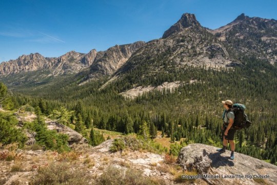
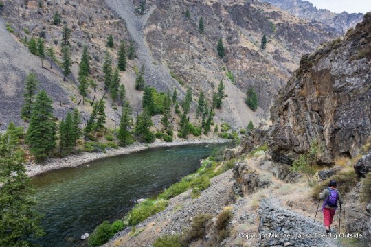
Lisa Fenton hiking Idaho’s Middle Fork Salmon River Trail.
The IWT stretches for 285.6 trail miles through these three wilderness areas, between its southern terminus on the outskirts of the tiny town of Atlanta, to its northern terminus at Wilderness Gateway campground on US 12. It can be hiked as three or four distinct sections or thru-hiked in a month or less—a more-reasonable distance and time commitment for many backpackers than the AT or PCT. (See my tips and more information on backpacking the IWT in the Take This Trip section at the bottom of this story.)
I’ve backpacked the John Muir Trail and parts of the Pacific Crest Trail, Appalachian Trail, and other long-distance footpaths. The IWT matches them for scenic beauty, but far eclipses them in terms of solitude.
And while the AT, JMT, PCT and other long-distance paths are generally well-marked and well-maintained—and mostly beginner-friendly and popular enough that you’re likely to regularly encounter other backpackers who might offer help if you need it—the IWT poses significant challenges for its remoteness, dearth of people, and rough condition along some stretches. I’ve hiked through parts of the Frank, for instance, where trails go years without maintenance. I’ve seen footpaths that have essentially disappeared beneath overgrowth.
I can help you plan this or any other trip you read about at my blog. Find out more here.
Much of the Idaho Wilderness Trail is no beginner backpacking trip.
Among the unique qualities of the IWT are some that don’t always come immediately to mind when you think about backpacking. Camping in these wilderness areas, you will gaze up at one of the darkest night skies in America—the Milky Way looks like it was painted across the heavens. A 1,400-square-mile area encompassing the Sawtooth and neighboring White Clouds wilderness areas has been officially recognized for the untainted blackness of its night sky with the designation of the Central Idaho Dark Sky Reserve, the country’s first dark sky reserve.
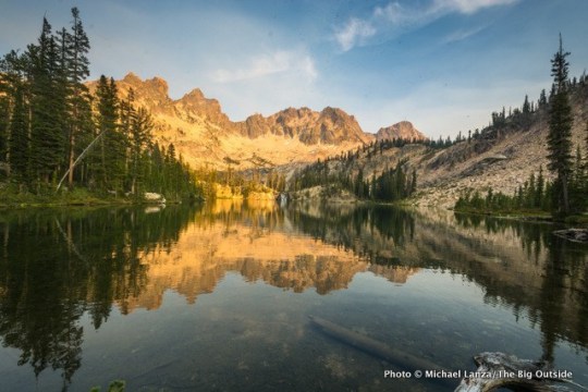
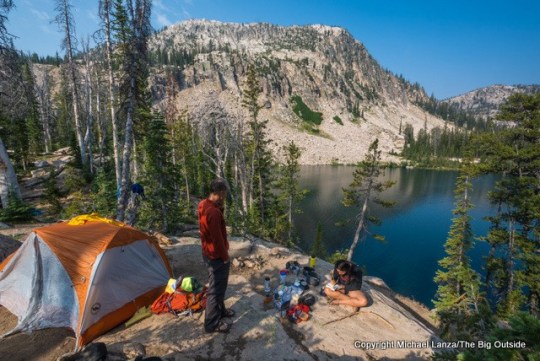
Sunset at Middle Cramer Lake, Sawtooth Mountains, Idaho.
And those night skies aren’t just in the Sawtooths. I have also gazed up at night skies in the Frank and Selway-Bitterroot so dark that I’ve at stared for endless minutes, transfixed.
And nowhere else will you breathe as easily. Designated a Mandatory Class I air quality area by the 1977 Clean Air Act, the Sawtooth Wilderness has the clearest air in the continental United States. You can bet the air in the Frank and Selway-Bitterroot is nearly if not just as clean.
Beyond introducing more backpackers to these wildernesses, a primary objective of our effort is to use the IWT as a communication vehicle to promote wilderness values and, hopefully, gradually grow a larger constituency of people willing to pitch in to protect and maintain it. That support is desperately needed because these places suffer from decades of chronic under-funding that has created shocking trail-maintenance backlogs throughout the U.S. Forest Service.
Because loving anything isn’t enough by itself. You have to show the love.
Plan your next great backpacking trip in Yosemite, Grand Teton, and other parks using my expert e-guides.


True Wilderness
Twenty summers ago, I backpacked a roughly 160-mile, north-south traverse of central Idaho’s wilderness, from a remote, grass airstrip on Moose Creek in the Selway-Bitterroot—where a friend and I stepped out of a six-seater prop plane to begin our trek—to the end of a remote dirt road at the foot of Sleeping Deer Mountain in the Frank.
That friend accompanied me for the trip’s first week; I did the second week solo, until two other friends met up with me the last night before I finished. During those two weeks, I hiked through rugged, breathtaking mountains, and canyons thousands of feet deep that impressed upon me the scale and remoteness of these places.
Few backcountry experiences in my life, before or since, have given me such a powerful sense of wilderness and solitude as that trip. Just two Alaskan adventures come immediately to mind, in fact: backpacking in Denali National Park and sea kayaking in Glacier Bay National Park.
Much of what I hiked that summer long ago is now the Idaho Wilderness Trail.
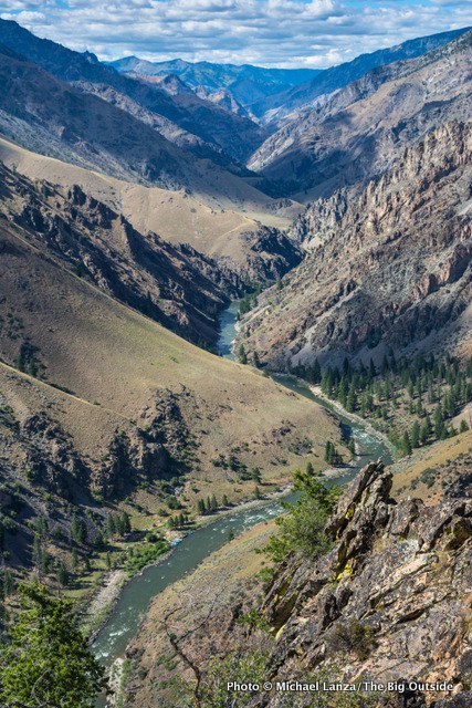
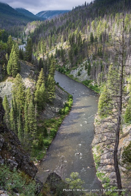
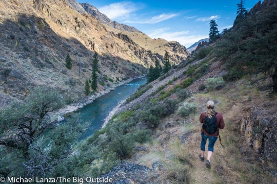
The view from Johnson Point of the Middle Fork Salmon River canyon.
And the defining characteristic of that two-week hike—what made it feel so different from the many other backpacking trips I’ve taken in some of America’s signature wild landscapes—was the solitude. While I encountered rafters and kayakers along the Main Salmon and Middle Fork Salmon rivers (and was the grateful recipient of meals generously offered by them), I saw exactly two other backpackers in two weeks. And they were on the Middle Fork Salmon Trail. For several days of backpacking through the mountains between those canyons, I saw no one.
Where else in the Lower 48 can you backpack for two weeks in the peak of summer and see not another person for days?
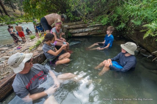
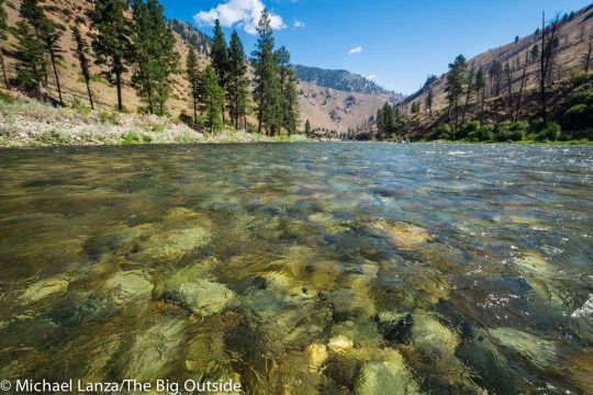
More recently, in July 2015 and again in July 2019, I floated the Middle Fork of the Salmon through the Frank with my family and 20 friends (on each trip), guided by my favorite river company, Middle Fork Rapid Transit. (See these photos from our most-recent trip and watch for my upcoming story about it.) Besides running scores of exciting rapids on a wilderness river, one of the most unique features of floating the Middle Fork is the abundance of side hikes to waterfalls, hot springs, high points, along tributary creeks. We took several hikes on the Middle Fork Salmon Trail, which parallels much of that river, sometimes hugging its banks, sometimes meandering hundreds of feet above river level to afford long vistas of that canyon of indescribable beauty.
Hiking the Middle Fork Salmon Trail—which the IWT follows—gave me a fresh perspective on the magic of the Idaho Wilderness Trail. That now has me planning to backpack the IWT’s longest section, through the Frank Church-River of No Return Wilderness.
Accessorize wisely. See my “Review: 22 Essential Backpacking Gear Accessories.”


The Most Remote and Wild Trail
As the ICL team and I worked on creating the IWT, we settled pretty quickly on a slogan that epitomizes the IWT: “The most remote and wild long-distance trail in the Lower 48.”
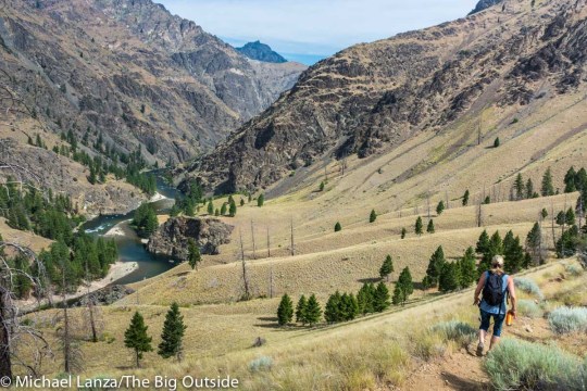
Much of the IWT lies at least a day’s hike from the nearest road—in long stretches of it, multiple days. Even in the Sawtooths, the smallest and most accessible of the three wildernesses traversed by the IWT, backpackers must devote significant time and effort to explore the trail.
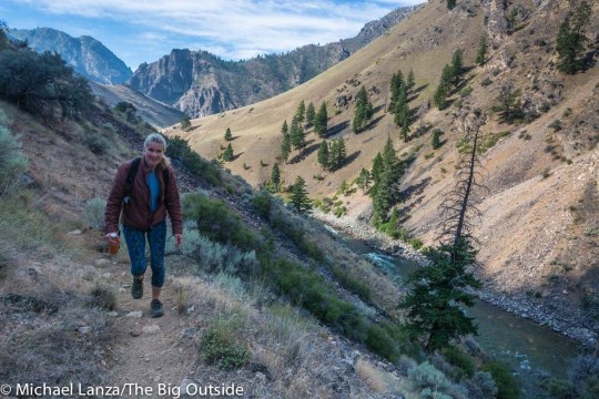
On that August backpacking trip in the Sawtooths that I described at the beginning of this story, our group left a wonderful campsite beside Edna Lake on our third morning and started hiking uphill toward Sand Mountain Pass. And within minutes, we turned at a trail junction and left the Idaho Wilderness Trail behind—having spent only about two days, cumulatively, of our four-day trip on it.
Edna Lake in Idaho’s Sawtooth Mountains.
But that illustrates the IWT’s remoteness: Even in the relatively accessible Sawtooths, the IWT traverses the most inaccessible corners of those fabulous mountains.
Take my advice: Walk this trail. You will discover some of the finest wilderness lands in America, and an experience every backpacker should have.
See all of my stories about the Sawtooth Mountains and the Frank Church-River of No Return Wilderness at The Big Outside.
Read all of this story, including my tips on planning this trip, and ALL stories at The Big Outside, plus get a FREE e-guide. Join now!
Take This Trip
THIS TRIP IS GOOD FOR fit, experienced backpackers with expert navigation and backpacking skills—not beginners—at least on the more difficult, remote, and in spots infrequently maintained sections of the Idaho Wilderness Trail, especially in the Frank Church-River of No Return Wilderness and Selway-Bitterroot Wilderness. On other sections, particularly traversing the Sawtooth Wilderness on the IWT, trails are generally well maintained, obvious, and signed at junctions—appropriate for beginner to intermediate backpackers.
Challenges include significant elevation gradients of 3,000 feet to more than 5,000 feet separating valleys and canyon bottoms from mountainous terrain; mountain passes reaching over 9,000 feet; possible thunderstorms and other weather; and the physical and mental rigors inherent to any long, remote trek. Some stretches of the IWT—again, mainly in the Frank and Selway-Bitterroot—lie multiple day’s walk from the nearest road.
Trying to figure out if you’re ready for the remote parts of the IWT? See my story “Are You Ready for That Outdoor Adventure? 5 Questions to Ask.”
See also my expert tips in “How to Prevent Hypothermia While Hiking and Backpacking” and my “8 Pro Tips for Preventing Blisters When Hiking.”
By Michael Lanza
We emerge from our tents on a mild August
morning to discover that the waters of the upper and middle Cramer Lakes, in
Idaho’s Sawtooth Mountains, have transformed overnight. Where last evening these
lakes on either side of our campsite had been rippled by mountain breezes, now
they lie perfectly still; they are glassy mirrors offering inverted, sharp reflections
of the forest and jagged peaks surrounding the lakes. A few hours later, our
backpacking party of three parents and six teenagers hikes across wildflower
meadows and past alpine tarns to proudly reach a mountain pass at over 9,000
feet on the Cramer Divide, overlooking a turbulent sea of razor peaks stretching
to every horizon.
Map and Guide See an overview map of the Idaho Wilderness Trail at drive.google.com/file/d/11GOZEV1ufser-wbHh9SniDkdXeJKyN2Q/view?ts=5ce5d90e. The Idaho Conservation League hosts a website describing the IWT at idahoconservation.org/events/plan-your-own-adventure/idaho-wilderness-trail. We are currently working with a cartographer to produce section maps of the IWT that will be available for sale online; more information to come when they are ready.
Want to make your pack lighter and all of your backpacking trips more enjoyable? See my story “A Practical Guide to Lightweight and Ultralight Backpacking.” If you don’t have a paid subscription to The Big Outside, you can read part of that story for free, or click here to download that full story without having a paid membership.
Find categorized menus of gear reviews, expert buying tips, and best-in-category reviews at my Gear Reviews page.
Guide/Outfitters/Rentals Various guide services offer backpacking, river float trips, climbing, fishing, and other trips in these wilderness areas, providing access to parts of the Idaho Wilderness Trail. My family has taken a couple of outstanding, six-day float trips down the Middle Fork of the Salmon River in the Frank Church Wilderness with Middle Fork Rapid Transit (middleforkrapidtransit.com), an adventure that offers almost daily opportunities to hike parts of the IWT that overlap the Middle Fork Salmon Trail through that magnificent canyon.
Contact Idaho Conservation League, idahoconservation.org/events/plan-your-own-adventure/idaho-wilderness-trail/
Tell me what you think.
I spent a lot of time writing this story, so if you enjoyed it, please consider giving it a share using one of the buttons at right, and leave a comment or question at the bottom of this story. I’d really appreciate it.
0 notes
Photo
By Michael Lanza
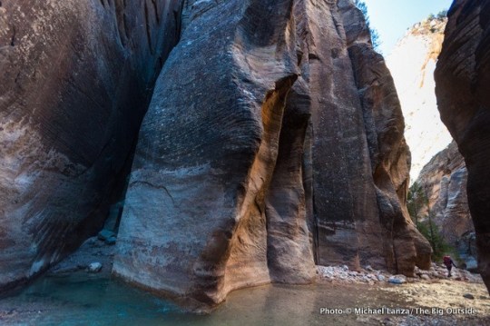
We step into the ankle-deep North Fork of the Virgin River, in the backcountry of Zion National Park, and water at refrigerator temperature immediately fills our boots. Until sometime tomorrow afternoon, we’ll walk in this river almost constantly, crossing it dozens of times—with the 50° F water, at its deepest, coming up nearly to our waists. As we splash downstream, the canyon walls of golden, crimson, and cream-colored sandstone steadily creep inward and stretch higher, soon eclipsing the sun. We’ll see very little direct sunlight as the sheer walls of Zion’s Narrows eventually tower a thousand feet overhead and, at times, close in to the width of a hobbit’s living room.
Drinking in the scenery, I’m feeling a surreal sense of luck just to be in this place, considering that, for various reasons, it has taken my friend David Gordon and I a few decades to finally get here—and the fact that it’s sunny and warm in November as we set out on one of the most uniquely beautiful and sought-after backpacking trips in the entire National Park System.
The Narrows is the roughly 14 miles of the North Fork’s canyon upstream from where the road in Zion Canyon ends at the Temple of Sinawava. Enormously popular, the lower end of the Narrows teems with hundreds and sometimes thousands of dayhikers on hot days of late spring and summer, when the river is warm and low. Many of those people don’t go beyond the first mile or two of the Narrows, while some hike as far as Big Spring, five miles upriver, the farthest point you’re allowed to venture without a wilderness permit.
Backpacking the Narrows from top to bottom—16 miles from the Chamberlain’s Ranch trailhead to the Temple of Sinawava trailhead—requires a permit that’s very hard to get, whether you try to reserve a campsite in advance (they get scooped up as soon as they become available) or try to get a permit on a walk-in basis no more than a day in advance of starting the two-day trip.
Click here now to get my e-guide The Complete Guide to Backpacking Zion’s Narrows.
David Gordon on day one backpacking the Narrows, Zion National Park.
But there’s one other way of snagging a permit—perhaps the easiest, given the towering hurdles of the other two methods, though it does involve pure luck. The park holds a Last Minute Drawing for unreserved campsites between seven and two days prior to the date you’d like to start. (See Permit info in the Make It Happen section at the bottom of this story.) When I saw an unusually warm, sunny forecast for the first week of November—not a high-demand time for Zion permits—I grabbed two of the most-coveted wilderness permits in the National Park System through the Last Minute Drawing: backpacking the Narrows top to bottom, and dayhiking Zion’s Subway top to bottom. (Read my story “Luck of the Draw, Part 1: Hiking Zion’s Subway.”)
David and I have both had backpacking Zion’s Narrows in our sights literally for decades. But for various reasons—including the short season and stiff competition for permits for both—it has taken us this long to get to them. Now, thanks to watching the forecast, good timing, flexibility in our schedules, and sheer luck, we are spending three straight November days of temperatures in the 60s knocking off two of the best hikes in America—the Subway and the Narrows—and seeing relatively few people, a situation unheard-of during the peak seasons.
After the Narrows, hike the other nine of my “10 Best Backpacking Trips in the Southwest.”
Hi, I’m Michael Lanza, creator of The Big Outside, which has made several top outdoors blog lists. Click here to sign up for my FREE email newsletter. Join The Big Outside to get full access to all of my blog’s stories. Click here to learn how I can help you plan your next trip. Please follow my adventures on Facebook, Twitter, Instagram, and Youtube.
The Narrows Day One
By mid-afternoon, a few hours into the hike, the only evidence of sunshine that we see is where it sets fire to the upper canyon walls, a few hundred feet above us. Down in the canyon’s basement, we walk in the shadows of a premature, extended dusk.
Here in the upper Narrows, several miles above its confluence with Deep Creek, which triples the river’s volume, the North Fork of the Virgin River meanders through adolescence, a skinny but energetic stream—at least during times of low water levels, which is when park officials open the Narrows to hikers. (See the Make It Happen section at the bottom of this story for details about safe river levels for hiking.) We’re still above the true “narrows” stretch of the canyon; pine trees grow sparsely along the river, like thin hair on an old man’s head, and the rims wear a green crown.
Day one in the upper Narrows, Zion National Park.
Black water streaks bleed down blood-red walls smeared with spilled-paint splotches of white rock. At sharp riverbends, where flash floods and high water have done the destructive work of erosion, cliffs crest overhead in petrified waves.
Our canyoneering boots and neoprene socks do not keep our feet warm so much as prevent them from getting painfully cold; I wouldn’t do this hike without them, except perhaps in really hot weather. We’re also carrying dry suits in our packs for the deeper water we’ll encounter later today and tomorrow. Here, we don’t need them yet for water that rarely tops our ankles. (See details on gear at the bottom of this story.)
Eons of geological uplift and the erosional force of the river carving into the Navajo Sandstone created the Narrows. Floods continue that eternal work. The Narrows and many other similarly tight canyons can transform from placid to deadly in a span of minutes—which is why you should avoid them if there’s any chance of rain. A flash flood in 1998 abruptly raised the Virgin River’s volume from 200 to 4,500 CFS (cubic feet per second), acting like a giant, high-speed plow coursing downstream, damaging the park road in Zion Canyon. On Sept. 15, 2015, seven people descending a slot known as Keyhole Canyon were killed in a flash flood in the worst disaster in the history of Zion National Park.
By late afternoon, we reach the beginning of the true “narrows” section. The walls pinch down to 15 to 20 feet apart and shoot up several hundred feet. For the rest of this day, we’ll wade water that comes up to our calves—and briefly higher—through a dark, cool, and church-quiet hallway in solid rock, with only a sliver of sky visible high above us.
We hear the North Fork Falls well before we see it. At 8.5 miles from the trailhead, the river pours thunderously over a 10-foot-tall, boulder-and-log jam. To bypass it, we squeeze through a claustrophobic passage on the south side of the waterfall, between a massive boulder and the canyon wall, and then wade a short distance back upstream to see the waterfall.
I can help you plan this or any other trip you read about at my blog. Find out more here.
David Gordon on day one backpacking Zion’s Narrows.
Minutes beyond the North Fork Falls, we clamber over a log pinned between the close walls and lower ourselves into the deepest pool of the day. The numbing water rises crotch-deep on me; I wade across it as quickly as I can propel myself forward into shallower water. Around the corner, we reach our home for the night, campsite one, the first of a dozen designated campsites in the Narrows. (This campsite made my top 25 all-time favorite backcountry campsites, and I grouped the 11 other sites in the Narrows together as one on my list of the 15 nicest backcountry campsites I’ve hiked past.)
Our camp sits on a slightly elevated patch of dry ground, on one side of a cavernous opening where a tributary canyon joins the North Fork. Within an hour, by 6 p.m., it’s completely dark. With no moon out yet, stars riddle the Y-shaped slice of sky visible to us above this confluence of two canyons.
After dark, a mouse skitters around our site, obviously accustomed to pilfering food from backpackers. As David sits on a log enjoying the quiet and the stars, he feels the mouse crawling up his pant leg and kicks it off. With the forecast for clear weather, we didn’t bring a tent; we lay our pads and bags on the comfortable bed of soft, dry sand. But a few times during the night, I feel the mouse crawling up the outside of my bag and kick a leg out to send it airborne.
See my “10 Tips For Getting a Hard-to-Get National Park Backcountry Permit.”
The Narrows Day Two
In the morning, we awaken to a clear sky—what we can see of it, anyway. At the bottom of this deep hole, beneath close walls that dwarf skyscrapers, we remain in deep shadow. A breeze blowing down canyon sharpens the knife-like chill in the air, as the temperature sits in the high 30s Fahrenheit. The forecast had called for lows in the 20s, so we’re lucky on that count. But “lucky” isn’t the word I mutter while tugging my wet, stiff, half-frozen neoprene socks and boots on over my feet and taking my shocking first steps back into the 50-degree river.
Before long, though, the air temperature starts rising and our feet warm up as blood finally seeps back into them—even as we’re constantly crossing the ankle- to calf-deep river. I shed two of the three shirts I’m wearing and my wind shell, and roll the top of my dry suit down to my waist, thinking: It’s November, and I’m hiking in shirtsleeves.
Want to take this trip? Click here now to get my e-guide The Complete Guide to Backpacking Zion’s Narrows.
youtube
Low-angle sunlight gradually infiltrates the canyon. Some walls catch indirect light reflecting off other walls, making them appear to glow. At every turn, the cliffs display a different face, a complex mosaic of curves, cracks, columns, pinnacles, and buttresses in a rich geological color palette. Mature trees lend the green of conifers and, at this time of year, the yellow of cottonwood trees.
High above us, the wind blows clouds of dust off ledges, and the sun backlighting the tiny dust particles makes them sparkle as they float earthward. “Pixie dust,” I tell David. Moments later, a gust hurls leaves off the rims hundreds of feet overhead, creating an identical effect, the leaves twinkling in the sunlight as they float downward.
An hour out of camp, below campsite four, we see the first people we’ve encountered since we started hiking from Chamberlain’s Ranch yesterday—two backpackers who remain ahead of us and mostly out of sight.
. . .
Tell me what you think.
I spent a lot of time writing this story, so if you enjoyed it, please consider giving it a share using one of the buttons at right, and leave a comment or question at the bottom of this story. I’d really appreciate it.
0 notes
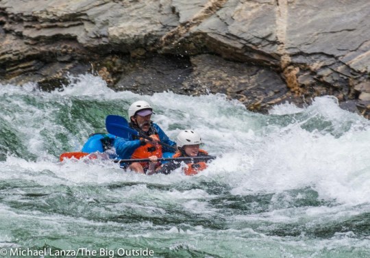
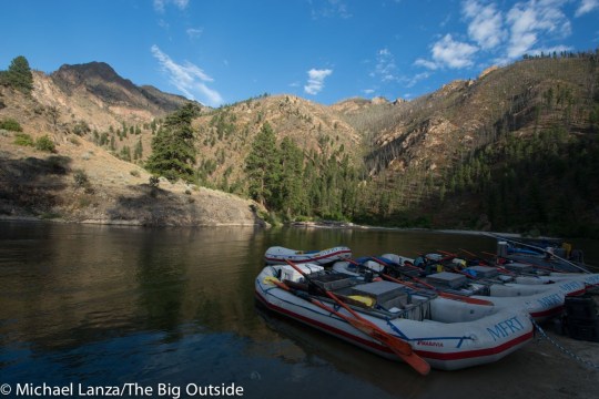
Photo

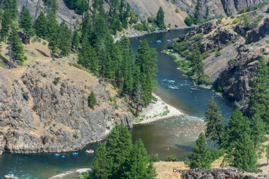
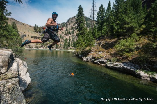
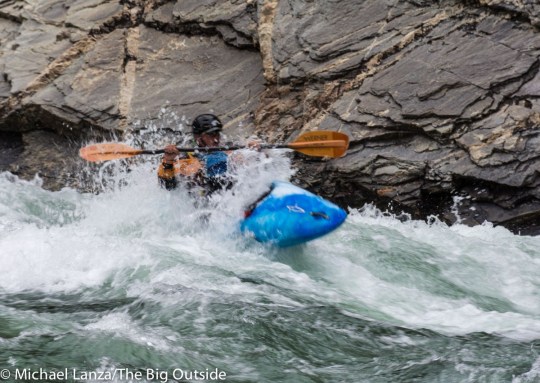
As our big group of several families and friends disembarked from our flotilla of rafts and kayaks and wandered up to our campsite on a sandy beach beside the river, I started surveying facial expressions. We had just finished the first day of a six-day float trip down Idaho’s Middle Fork Salmon River—a day filled with running rapids, swimming, cliff jumping, fishing, and drifting lazily down one of the West’s most lovely river canyons—and I wondered: What was everyone thinking?
It didn’t take long to ascertain the collective mood: All I saw were smiles, laughter, and the kind of deep calm most of us don’t experience often enough. This did not surprise me. I knew from experience that’s the effect the Middle Fork has on people.
In mid-July, our party of 30, consisting of my family and two generations of several other families from as near as Boise and as far as the Boston area and Germany, plus our skilled and very fun guides from Middle Fork Rapid Transit, took one of the classic multi-day, wilderness river trips in America—and arguably, the greatest. The Middle Fork, deep in the largest federal wilderness area in the Lower 48, central Idaho’s 2.4-million-acre Frank Church-River of No Return Wilderness, has earned this renown for having some 300 ratable rapids, many of them class III and IV, beautiful campsites and side hikes, hot springs, and world-class trout fishing—and being one of the prettiest rivers to ever carve a twisting canyon through mountains.
Hi, I’m Michael Lanza, creator of The Big Outside, which has made several top outdoors blog lists. Click here to sign up for my FREE email newsletter. Join The Big Outside to get full access to all of my blog’s stories. Click here to learn how I can help you plan your next trip. Please follow my adventures on Facebook, Twitter, Instagram, and Youtube.
We saw bighorn sheep, bald eagles, and osprey, and took side hikes that ranged from the riverbanks to hundreds of feet above the river, with long views up and down the canyon.
Running thrilling whitewater every day, the trip descends more than a vertical half-mile through a canyon that changes from a forest of lodgepole pine and Douglas fir at higher elevations, to open terrain of ponderosa pine and rolling, grassy hills in the middle canyon, and finally the lower Impassable Canyon, the third-deepest gorge in North America, where sheer cliffs rise straight out of the river and we crashed through a swift succession of rapids.


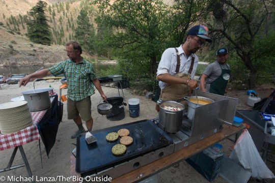


This was my family’s second trip with Middle Fork Rapid Transit, which specializes exclusively in trips on the Middle Fork of the Salmon—and who I highly recommend, because they take their trips to a higher level: Not only is the food excellent and the guides skilled, experienced, and knowledgeable about everything from the canyon’s natural and human history to the current state of endangered salmon, but MFRT assembles a guide crew who are uniquely interesting people with rich lives outside of their guiding jobs.
Find your next adventure in your Inbox. Sign up now for my FREE email newsletter.
Watch for my upcoming feature story about our float trip down the Middle Fork Salmon River. Meanwhile, see my feature story about our first trip down the Middle Fork; that story has many photos and more details about planning it.
And see all of my stories about family paddling trips and all of my stories about family adventures at The Big Outside.
Tell me what you think.
I spent a lot of time writing this story, so if you enjoyed it, please consider giving it a share using one of the buttons at right, and leave a comment or question at the bottom of this story. I’d really appreciate it.
0 notes
Photo

I can’t help but in my LBD! 🖤 Seriously, where has been all my life! Who knew wearing my favorite could look and feel this good. They definitely own it in the “push up” category. Every girl should have this staple in their closet! Check out to get my new year, new style secret.🤫 #dress ddict gepony asuita e premium er loveourshop
https://www.amazon.co.uk/KISSBOBO-Sophisticated-Distinctive-Strapless-Invisible/dp/B07BVQJN99/ref=sr_1_fkmrnull_3?keywords=Adhesive+bra&m=A45ZTIYUMU6L1&qid=1557193176&s=merchant-items&sr=1-3-fkmrnull
#vauntit#vauntitdress#dressur#dressy#dresses#dressoftheday#dressa#dressaddict#dressagepony#adress#adressasuita#adresse#adresspremium#dressbarn#dressbyairin#bdress#bdresser#bdressloveourshop
0 notes
Photo
Hi Michael!
How are you? I have a quick question. Jerry and I always do a long dayhike for our anniversary. This year is our 24th, so we’re looking for a 24- to 26-mile epic dayhike and we want to do the Teton Crest Trail. But we can’t swing the entire 40-miler this year. We heard that there’s a 25-mile route that is epic in itself, from Death Canyon to Static Peak Divide to Cascade Canyon.
Where do we start and end? I read your great blog post on the entire hike, but curious about the 25-mile section.

A backpacker in the South Fork Cascade Canyon, Grand Teton National Park.
Thanks!
Shelli
Lander, WY
Hey Shelli,
Twenty-four years, wow. Congrats. So awesome that you two go on huge dayhikes together to celebrate. And the second half of summer is an ideal time for hiking in the Tetons.
Start at Death Canyon Trailhead, ascend to Static Peak Divide, cross Alaska Basin, then follow the Teton Crest Trail past Sunset Lake, over Hurricane Pass into South Fork Cascade Canyon, and finish at the boat ramp on Jenny Lake, at the bottom of Cascade Canyon. If you miss the last boat, it’s a long two-plus miles around Jenny Lake.
It’s a big hump from Death Canyon to Static Peak Divide, more than 4,000 vertical feet, so try to hit it early, in cooler temps and some shade. Static Peak has a short spur trail to a very worthwhile summit view at 11,303 feet.
Hi, I’m Michael Lanza, creator of The Big Outside, which has made several top outdoors blog lists. Click here to sign up for my FREE email newsletter. Join The Big Outside to get full access to all of my blog’s stories. Click here to learn how I can help you plan your next trip. Please follow my adventures on Facebook, Twitter, Instagram, and Youtube.
It’s just over 22 miles from Death Canyon Trailhead over Static Peak Divide to Cascade Canyon, so maybe not quite as far as you were planning. But I’ve hiked that entire section and it is awesome. The alpine stretch of trail from Static Peak Divide to Alaska Basin feels really remote and wild, and you don’t see many people there, if any.
From Alaska Basin to Hurricane Pass, you cross an undulating, alpine plateau with sweeping 360-degree views of the mountains. The South Fork of Cascade Canyon is beautiful, especially the upper part of it, following the spur trail leading south to Avalanche Divide—a really nice section. It adds three miles round-trip to your day, but that would put you right around your distance goal, at 25 miles.
Dying to backpack in the Tetons? See my e-guides to the Teton Crest Trail and
the best short backpacking trip there.
Passing the Schoolroom Glacier in upper South Fork Cascade Canyon.
I’ll suggest a variation on this route for you guys that’s slightly more direct, but more rugged, too, and I think more scenic: Well beyond (north of) Static Peak, hiking north toward Alaska Basin but before you reach it, you’ll see (if it hasn’t disappeared) an unmarked but obvious trail (it was obvious when I hiked it some years ago) branching right and going uphill. It leads to a notch at the south end of The Wall (that name is marked on maps) where you can easily cross over into the head of Avalanche Canyon. It’s actually a trail the park decommissioned decades ago, but still partly exists on the ground.
The spur trail from South Fork of Cascade up to Avalanche Divide is the continuation of that same trail, and the only piece of it still in maintained condition. The park gave up trying to maintain the section of trail across the head of Avalanche Canyon, and there’s no trace of it remaining on Avalanche Canyon; but it’s reasonable cross-country hiking after you make an initial, steep and loose descent of scree—not too bad for anyone with experience on steep scree. From Snowdrift Lake to Avalanche Divide is low angle, easy, and quite obvious. Taking this route misses much of Alaska Basin and Hurricane Pass, but I think it’s worth the trade-off for the greater sense of adventure and the scenery. However, it would be slower and much rougher. If you’s prefer a cruiser hike, stick with the maintained trails on the route I described above.
I can help you plan this or any other trip you read about at my blog. Find out more here.

Backpackers above Sunset Lake on the Teton Crest Trail.
I have also dayhiked up Avalanche Canyon, over Avalanche Divide, and down Cascade Canyon to Jenny Lake, about 20 miles. But Avalanche only has a rough user trail, and only through part of it, so it’s steep and hard. See a description of that hike in my story “8 Great, Big Dayhikes in the Tetons.”
The photo in my “8 Pro Tips For Preventing Blisters When Hiking” shows my friend David’s painful heels at the end of that hike.
Feeling inspired by this story? Join now for full access to ALL stories and get a free e-guide!

Shelli’s group in South Fork Cascade Canyon.
Either route I described above is excellent. Have fun.
See all of my stories about Grand Teton National Park, including “American Classic: The Teton Crest Trail.”
—Michael Lanza
Tell me what you think.
I spent a lot of time writing this story, so if you enjoyed it, please consider giving it a share using one of the buttons at right, and leave a comment or question at the bottom of this story. I’d really appreciate it.
0 notes
Photo

we did each other’s homework wrote letters kept in touch, untouching lied about our lives
https://www.ikissbobo.com/product/eco-chic-strapless-adhesive-invisible-bra/
0 notes
Photo
By Michael Lanza
I’m writing to you today because I appreciate that you read my blog, and I want to know what you think and what you want. Yes, really.
Whether you’ve been reading it for years or only recently discovered The Big Outside, I hope you see that I’m striving to share stories, images, and information that inspire and help you do the things you love to do outdoors. Now I’d like to know more specifically what you think of my blog—and what you’d like to see more of.
That’s why I’m hoping you’ll please take just a few minutes to fill out this reader survey, and I’m offering a gift to show my appreciation for you doing that.
Me hiking in the Monolith Valley in Idaho’s Sawtooth Mountains.
The survey below will take you about five minutes to complete. (That’s less time than it takes to apply for a national park backcountry permit—I should know, I’ve applied for a lot of permits!)
To show my appreciation for you taking the time to complete my reader survey, I’m going to give away a three-month subscription to The Big Outside for free to one person selected randomly from among everyone who completes the survey.
If you win and you’re already a paying subscriber, I’ll add three months to your subscription at no cost to you.
Honestly, given the number of people who generally respond to any survey, your odds are pretty good of winning three months of full access to my blog for free. It’s as easy as that.
a Rafflecopter giveaway
Just complete the survey below, and then scroll back up and click the raffle box above to enter my giveaway of a three-month subscription to The Big Outside.
Don’t wait! I’m running this survey and giveaway for just a few days. Fill it out and enter to win a free subscription to The Big Outside now!
Thank you for taking the time to let me know what you think about my blog. I appreciate it.
Thanks also for reading and following The Big Outside.
Name *
First
Last
Email *
Overall, what do you think of The Big Outside? *
Rate 1 out of 5Rate 2 out of 5Rate 3 out of 5Rate 4 out of 5Rate 5 out of 5
What is your gender?
Woman
Man
Trans
Prefer not to answer
What is your age?
Under 18
18-24
25-34
35-44
45-54
55 or over
What is your approximate income?
Under $50,000/year
$50,000 to $99,000/year
$100,000 to $149,000/year
$150,000/year or more
How did you discover The Big Outside? *
Google or another search engine
Social media
Heard about the site from someone
Read or heard about the site in another media (magazine, website, etc.)
Searched Michael Lanza online because I’d read his stories elsewhere
Other
How often do you visit TheBigOutside.com? *
Multiple times a week
Approximately once a week
2 or 3 times a month
Whenever I’m researching a trip, gear, or related subject
What types of stories at The Big Outside most interest you? (Check all that apply) *
Backpacking
Dayhiking
National Parks
Family Adventures
Gear Reviews
How-to Skills Tips
Paddling
What kind of stories would you like to see more of at The Big Outside? (optional)
Have you purchased a paid subscription/membership for full access to all stories at The Big Outside? (See https://thebigoutside.com/join/) *
Yes, I’m a paying subscriber
Yes, I subscribed previously but do not currently
No, I have never purchased a paid subscription
If you do not have a paid subscription/membership to The Big Outside, why not?
Too expensive
I don’t need to access stories that require a paid subscription
I didn’t know that many stories require a paid subscription to read
Have you ever purchased gear through links in reviews at The Big Outside? (Scroll down to the Gear Reviews box at https://thebigoutside.com/) *
Yes, at least once
Yes, multiple times
No, I purchase gear elsewhere
No, I have little need to purchase gear
Have you purchased, or would you ever purchase the Custom Trip Planning service at The Big Outside? (See https://thebigoutside.com/custom-trip-planning/) *
Yes, I have used your Custom Trip Planning service
I haven’t yet but will probably use your Custom Trip Planning service
I have no need for a Custom Trip Planning service
I didn’t know about your Custom Trip Planning service
Have you ever purchased a downloadable e-guide from The Big Outside? (See https://thebigoutside.com/e-guides/) *
Yes, one e-guide
Yes, more than one e-guide
No, I don't need an e-guide
I didn’t know about the e-guides
If you have purchased a downloadable e-guide from The Big Outside, were you satisfied with it? (If you have not purchased one, please skip this question.)
Very satisfied
Somewhat satisfied
Unsatisfied
If you have purchased an e-guide, what did you like and/or not like about it? (If you have not purchased one, please skip this question.)
Would you like to see The Big Outside offer any of these products or services? (Check all that you would like to see.)
More downloadable e-guides to the best U.S. backpacking trips
Downloadable e-guides to the best dayhiking trips in the U.S.
Downloadable e-guides to the national parks
Downloadable e-guide on becoming an expert backpacker
Downloadable e-guide to beginner backpacking
Downloadable e-guide to lightweight and ultralight backpacking
Downloadable e-guide on family backpacking
Downloadable e-guides to the best international adventures
A field-based, instructional backpacking program led by Michael Lanza
Michael Lanza’s photos available for sale at The Big Outside
How likely are you to recommend The Big Outside to someone you know? *
Very UnlikelyUnlikelyNot SureLikelyVery Likely How likely?How likely? Very UnlikelyHow likely? UnlikelyHow likely? Not SureHow likely? LikelyHow likely? Very Likely
Thank you very much for taking the time to fill out this survey about The Big Outside. I really appreciate it. Do you have any more suggestions for Michael Lanza and The Big Outside?
Website
Submit
0 notes
Photo

What's my fav fall essential? of course! I’m in love with all the new fall trends - Asymmetrical necklines, shirts and dresses with cutouts and of course those ultra cute off the shoulder sweaters. Seriously this push up bra allows me to pull off any backless and strapless outfit - in any season. Being limited by my style options used to be super annoying, not anymore! Check out their full lineup at 😍😘 ootd plain floral printed ao black grey ao�
https://www.ikissbobo.com/product/allure-strapless-adhesive-bra/
#lskirt#lskirtootd#lskirtplain#lskirtfloral#lskirtprinted#skirtmidi#mskirt#mskirtao#mskirtblack#mskirtgrey#mskirtao�#skirtno1#skirtneelofa
0 notes
Photo

Hel goddess aesthetic moodboard I made
https://www.ikissbobo.com/product/la-symphonie-adhesive-strapless-drawstring-bra/
0 notes
Photo

It’s simple to wake from sleep with a stranger, dress, go out, drink coffee, enter a life again.
https://www.ikissbobo.com/product/la-symphonie-adhesive-strapless-drawstring-bra/
0 notes
Photo

Hyeongwhipped for Mingyu...
https://www.ikissbobo.com/product/lenchanteress-strapless-drawstring-bra/
0 notes
Photo
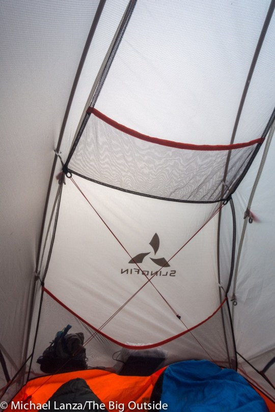
Ultralight Backpacking Tent
Slingfin Portal 2
$485, 2 lbs. 14 oz.
slingfin.com
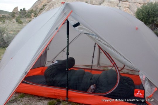
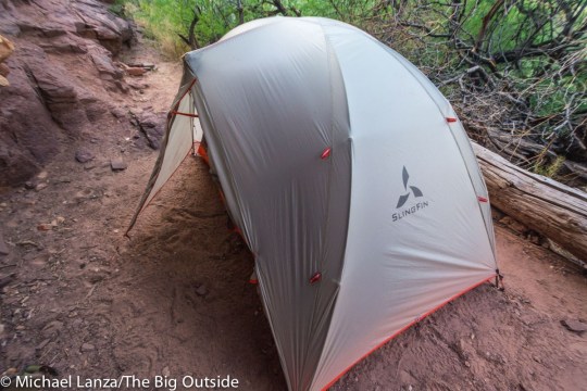
Everyone wants a super lightweight tent—which makes sense: Give that your tent is one of the heaviest pieces of gear you carry, it offers great potential for weight savings. But not everyone wants the drawbacks of an ultralight tent, which can include tight living quarters and, in particular, so-so stability in strong wind. Enter the Slingfin Portal 2, one of the sturdiest sub-three-pound tents out there, as I discovered on a six-day, 74-mile backpacking trip in the Grand Canyon and stormy nights camping at Idaho’s City of Rocks National Reserve.
In the Grand Canyon in mid-spring, the Portal 2 stood up to winds frequently gusting to 30 mph or more. And while camping at the City of Rocks in May, it also withstood similar winds—and survived a night of crazy wind events: The tent suffered no damage despite being lifted in the air by the wind—due entirely to the sandy soil not holding stakes well—and sent tumbling into sagebrush. But when the wind started blowing at least 50 mph one evening, I had to take the tent down because I was afraid poles would get snapped; I pitched it again later, after the windstorm passed.

Slingfin Portal 2 with a trekking pole inserted for added stability.
Those were unusual conditions that would trash many three-season backpacking tents, but also a reminder that even the strongest ultralight tents have limits—don’t expect performance approaching the stoutest (and much heavier) three-season or mountaineering tents.
Slingfin carried some technologies from mountaineering tents over to the Portal, to improve stability and weather resistance while keeping it under three pounds. It pitches using two DAC Featherlite NFL 8.7mm poles and one NFL 9mm pole. A trekking pole can optionally be used to prop up the rainfly at the peak of each vestibule, bolstering the tent’s wind resistance and strength under snow loads. Pre-installed internal guylines (similar to Slingfin’s 2Lite Trek) can be tensioned from inside to increase lateral stability when the wind’s blowing—and they add virtually no weight to the tent. (See instructions on installing a second set of internal guylines at slingfin.com.)
Find your next adventure in your Inbox. Sign up now for my FREE email newsletter.

Slingfin Portal 2 with rainfly doors rolled back.
Ten external guy points are matched to toggles to attach the fly to the poles for added structural strength in multi-directional wind. The toggles also allow rolling the fly up halfway over the tent—opening up night sky views while facilitating a quick switch to full rain protection during the night, if necessary, a very nice feature.
In short, the design gives the sub-three-pound Portal 2 the wind resistance you’d find in tents weighing at least a pound more.
Hi, I’m Michael Lanza, creator of The Big Outside, which has made several top outdoors blog lists. Click here to sign up for my FREE email newsletter. Join The Big Outside to get full access to all of my blog’s stories. Click here to learn how I can help you plan your next trip. Please follow my adventures on Facebook, Twitter, Instagram, and Youtube.
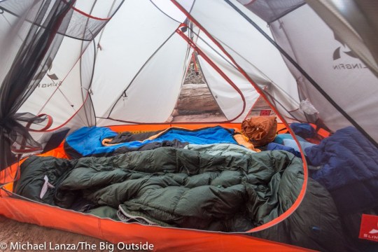
The Portal 2’s livability compares favorably with leading competitors in this weight class (like the Big Agnes HV UL2), with two doors and vestibules, a snug but tolerable 27.5 square feet of floor area, good length (85 inches) and width at the head (51 inches) and foot (42 inches), and a generous peak height (44 inches). The pole architecture boosts headroom without the hubs found on tents from other brands; Slingfin told me they consider hubs a “weakness.” There are seven internal pockets: two each on the ceiling, at the head, and on the sides and one at the foot.
All of the above attributes are noteworthy in a tent that’s under three pounds, although the packed size of 14×5 inches is typical for a tent in this category.

The offset vestibules each have 8.4 square feet of storage area, similar to many lightweight two-person tents.
Ventilation is good, thanks to the mesh interior canopy, vents high on both vestibule doors that can be propped open with struts that still provide full rain protection even when open. Having two doors, of course, greatly improves any tent’s ventilation. Both vestibule doors roll back to create openings nearly the size of the tent’s side walls—which, combined with the ease of rolling back the rainfly, gives the tent a wonderful, open-air feeling on clear nights—and can be kept open in light rain because the drip line doesn’t allow rain inside the tent.
It’s not the fastest three-season tent to pitch; trekking poles aren’t required (and unnecessary in calm weather) but do improve stability, and add time to the job. But it’s easy and faster after you’ve done it once or twice. Matching reflective tabs on the rainfly and tent body make pitching easier.
I can help you plan the best backpacking, hiking, or family adventure of your life. Click here now to learn more.


The Portal 2 is built with more durability than many ultralight tents. It uses 20-denier nylon ripstop in the floor, 15-denier nylon no-see-um mesh in the tent body, and an 1800mm, 10-denier nylon 66 ripstop silicone rainfly that, unlike PU coatings, doesn’t absorb water, meaning it won’t stretch and sag when wet. Slingfin employs fabrics with good UV and mildew resistance to extend their life, adds extra zipper sliders to double the lifespan of the zippers, and foregoes PU coatings that deteriorate over time. All stress-point seams are reinforced.
A footprint (sold separately, $67, 5 oz.) protects the tent floor and allows pitching the Portal 2 with only the rainfly, slashing the shelter’s total weight to two pounds two ounces. Alternatively, Slingfin also sells separately a Portal Tub Floor ($106, 7.5 oz.) that has sidewalls to keep water from splashing in when pitching it only with the rainfly, a setup that also weighs just two pounds two ounces.
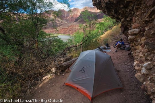
The Slingfin Portal 2 ultralight backpacking tent in the Grand Canyon.
The Verdict
While barely making the (arbitrary) weight limit for an ultralight tent, the Slingfin Portal 2 carves out a unique space in this category by striking a keen balance between solid stability and livability while weighing under three pounds, making it a good choice for any backpacker who wants to reduce pack weight while getting the wind resistance of a heavier tent.
BUY IT NOW You can support my work on this blog by clicking this link to purchase a Slingfin Portal 2 at slingfin.com.
Tell me what you think.
I spent a lot of time writing this story, so if you enjoyed it, please consider giving it a share using one of the buttons at right, and leave a comment or question at the bottom of this story. I’d really appreciate it.
See my “Review: The 7 Best Backpacking Tents” (which includes another Slingfin tent) and all of my reviews of backpacking tents, ultralight backpacking tents, backpacking gear, and ultralight backpacking gear that I like.
See also my “5 Tips For Buying a Backpacking Tent” and “How to Choose the Best Ultralight Tent for You.”
Want to make your pack lighter and all of your backpacking trips more enjoyable? See my story “A Practical Guide to Lightweight and Ultralight Backpacking.” If you don’t have a paid subscription to The Big Outside, you can read part of that story for free, or click here to download that full story without having a paid membership.
NOTE: I tested gear for Backpacker Magazine for 20 years. At The Big Outside, I review only what I consider the best outdoor gear and apparel. See categorized menus of all of my gear reviews at The Big Outside.
—Michael Lanza
Was this review helpful? Get full access to ALL stories at The Big Outside. Join now and a get free e-guide!
0 notes
Photo

It’s simple to wake from sleep with a stranger, dress, go out, drink coffee, enter a life again.
https://www.ikissbobo.com/product/la-symphonie-adhesive-strapless-drawstring-bra/
0 notes
Photo

♡ ‘til death, we do art. knight zim Styles 100
https://www.ikissbobo.com/product/eco-chic-strapless-adhesive-invisible-bra/
0 notes
Photo

Trying out the new push up bra! I’ve got strapless bras, backless bras, and push up bras... BUT now I have all three in one 🙌 And seriously they're so easy to put on Wearing code es age up yarianak esz murah fania ire er eronfire rd erjess
https://www.amazon.com/KISSBOBO-Symphonie-Strapless-Drawstring-Invisible/dp/B07HHXPVT8/ref=sr_1_1?m=A3UH6GDHLBVQZD&marketplaceID=ATVPDKIKX0DER&qid=1557041469&s=merchant-items&sr=1-1
#edressur#edresses#dressfromthefeetup#dressformen#dressforwork#dressforsuccessdk#fdress#fdresscode#fdresses#fdressage#fdressup#dressgoals#dressgirly#dressgucci#dressgreen#dressgirl#gdress#gdressyarianak#gdressesz#gdressmurah#gdressfania#dresshistory#dresshiresydney#dressh#dresshire#hdress#hdresser#hdresseronfire#hdressrd#hdresserjess
0 notes
Photo

By Michael Lanza
Our bus winds up a narrow road in the Vallée des Glaciers, below snowy peaks of the French Alps. We boarded it with about 10 other trekkers after a late-afternoon thunderstorm ripped the sky open while we enjoyed a café and tea with chocolate mousse and a slice of blueberry pie at the Auberge de la Nova in les Chapieux, a speck of a village along the Tour du Mont Blanc. As the bus rumbles into Ville des Glaciers, a cluster of old farm buildings, I ask the driver to stop.
My 80-year-old mother wants to get off and hike.
The rain has ceased, so my mom suggests—since we’ve only hiked about five miles so far today—that we hike the final 30 minutes uphill to our destination, a one-time dairy farm turned mountain hut, the Rifugio des Mottets. I glance around at the other trekkers on the bus—all of them somewhere between one-third and one-fourth my mother’s age. None are getting off with us. They are all content to ride the bus to the hut. As they all silently watch the old lady get off to walk the rest of the way, I’m pretty sure I see some sheepish expressions.
We are on day two of a nine-day trek on one of the most popular and majestic trails on the planet, the Tour du Mont Blanc. A roughly 106-mile (170k) footpath encircling the “Monarch of the Alps,” 15,771-foot (4807m) Mont Blanc, the TMB passes through three countries—France, Italy, and Switzerland. The trek normally takes at least 10 to 11 days and entails a demanding 32,800 feet (10,000m) of elevation gain and loss while crossing—depending on which route variants one takes—10 or 11 mountain passes, the highest approaching 9,000 feet (over 2600m).
Joanne Lanza, 80, hiking to the Col de la Seigne, Tour du Mont Blanc, France.
My mom, Joanne Lanza, and I are hiking alone only today; eight others in our group took a longer and more arduous route to tonight’s hut, and two more will join us in two days, in Courmayeur, Italy. And those two facts illustrate a prime attraction of the TMB.
Although the genesis for this trip was my desire to help my mother realize her dream of hiking in the Alps, my wife and two teenage kids, strong and experienced hikers and backpackers, would never hear of me going without them. Plus, I invited along some extended family and friends with a range of comfort levels and stamina in the mountains (but fortuitously including people who speak two of the three languages we will use on the TMB). Our group comprises a dozen people—we could field a soccer team.
Hi, I’m Michael Lanza, creator of The Big Outside, which has made several top outdoors blog lists. Click here to sign up for my FREE email newsletter. Join The Big Outside to get full access to all of my blog’s stories. Click here to learn how I can help you plan your next trip. Please follow my adventures on Facebook, Twitter, Instagram, and Youtube.
Facing the challenge of finding a multi-day Alps trek that could accommodate a diverse group, I had settled quickly on the Tour du Mont Blanc. Scenically, it has few rivals in the entire world, and we would sample the mountain culture—and food—of three nations. But most conveniently, the TMB passes through towns and villages and crosses roads frequently. While we will spend three nights in mountain huts—all in stunning surroundings, a unique Alpine experience that I wanted everyone to have—we will sleep most nights in hotel beds, something Mom’s 80-year-old muscles will appreciate. And the availability of public transportation almost every day allows Mom and anyone else to skip or shorten a hard section or sit out a rainy day.
Those convenient logistics led me to think this plan might actually work.
Ready to hike one of the world’s great treks?
Click here now for my e-guide “The Perfect, Flexible Plan for Hiking the Tour du Mont Blanc.”
Trekkers hiking to the Col de la Seigne, Tour du Mont Blanc, France.
Now, walking beside my octogenarian mother up the Vallée des Glaciers toward the Rifugio des Mottets, the only sounds are the soothing rumble of the river, the Torrent des Glaciers, and the far-off moans of an icy wind blowing off the 12,520-foot (3816m) Aiguille des Glaciers, looming above the valley.
Mom admonishes me to slow down. “Remember,” she says, “you’re hiking with a snail.” (Her informal hiking club proudly calls itself the Snails.)
We have barely begun a long, hard trek, and neither of us really knows how it will go for her, attempting to walk a substantial portion of this trail that wraps like a 106-mile-long lasso around the tallest mountain in the Alps. Although she continually amazes me in her physical stamina and pain threshold, still, the notion of an 80-year-old embarking on a multi-day hike through the Alps is kind of nuts.
But neither of us worries much about what lies ahead. And that calm optimism just may be the source of her strength.
Find your next adventure in your Inbox. Sign up for my FREE email newsletter now.
The Tour du Mont Blanc in Italy
An icy wind blowing down from a severely cracked glacier just above us scours the outdoor deck of the Rifugio Elizabetta Soldini as we step outside on our fourth morning on the Tour du Mont Blanc. Clouds the color of battleships cling to the tops of jagged peaks flanking the glacier, but down the Val Veny below us, rows of spires stand silhouetted against blue sky.
We’re heading in that direction. And my mother has made a unilateral decision to throw out my carefully crafted agenda.
Today, we face a nine-mile hike, with a substantial stretch of uphill, from the Elizabetta hut to the resort town of Courmayeur, Italy. I had expected my mom to walk an easy mile with us to a road and catch a bus to Courmayeur. But she decided that plan sounds a little too sedentary. She wants to hike the entire distance.
I will share this truth with you: The stereotype of the kindly old lady is a myth. Octogenarians can be irritatingly strong-willed. Especially the ones that go hiking.
My daughter, Alex, hiking toward Courmayeur, Italy, on the Tour du Mont Blanc.
In all seriousness, I think she’ll do fine—probably. Yesterday, hiking about six miles from Rifugio des Mottets to Rifugio Elizabetta, Mom had crushed the 2,100-foot ascent to the Col de la Seigne—a jaw-dropping mountain pass at 8,255 feet (2516m) where we crossed into Italy—in well under three hours. Not bad for a snail.
She naturally can’t match the pace of anyone in our group—especially the teenagers, my nephew, Marco, and my kids, Nate and Alex, who frequently bound ahead beyond sight and earshot. But she keeps plodding steadily forward, accompanied by me or others. Whenever the faster hikers stop to take pictures or grab a snack, she inevitably comes puttering along, the proverbial, persistent tortoise somehow always catching up with the hares.
Guido Buenstorf hiking to Courmayeur, Italy, on the Tour du Mont Blanc.
Her unflagging clip yesterday, in fact, resulted in us arriving at the Elizabetta hut by early afternoon—earlier than I had expected. And she apparently wasn’t tired yet, because when Alex, Marco, our German friend, Guido Buenstorf, and I announce we were taking an afternoon hike up a steep trail behind the hut to an overlook of the glacier, she was the only taker. An entire afternoon, she told me flatly, “is too long to just hang around in the hut.”
After a 45-minute walk from Elizabetta down the valley, we make a long, 1,500-foot climb through forest and then over open, grassy, wildflower meadows onto the rolling terrain of a ridge forming the southern wall of the Val Veni. Across the valley, the Brouillard and Freney glaciers carve wide paths amid a quiver of dark stone spires. Clouds obscure the heights of Blanc, but the view is breathtaking almost every step of the way.
Do this trek right with my e-guide “The Perfect, Flexible Plan for Hiking the Tour du Mont Blanc.”
About four hours after leaving the hut, we reach the top of ski slopes high above Courmayeur and descend a chair lift and gondola into town, where we meet up as planned with my sister, Julie, and her 21-year-old daughter, Anna, at the Hotel Crampon. That evening, we gorge on an excellent dinner at Ristorante La Terrazza, our meals ranging from margherita pizza for Alex and Marco to an exquisite gnocci in wild boar sauce that my wife Penny and I both eat.
A Dream of Trekking the Swiss Alps
In many ways, the route that led my mom and me to the Tour du Mont Blanc stretches over far more miles than we’ll hike this week. She has hiked and backpacked with me all over the U.S. for more than three decades. Bridging more than half my lifetime, it’s a route that we have kept walking together, in all honesty, longer than I’d ever expected.
In fact, I’ve twice thought that she and I had already taken our last, major hike together: the first time on a weeklong hut-to-hut trek in Norway’s Jotunheimen National Park that turned out cold, wet, and hard, when she was 75; and then hiking Mount St. Helens when she was 76, a very strenuous, 10-mile, 4,500-vertical-foot day that stretched into 11 hours before we finished. A year after St. Helens, when my family took a weeklong, hut-to-hut trek through Italy’s Dolomite Mountains, she very much wanted to join us. I reluctantly told her I didn’t think it was a good idea, and given how hard that trek was, I still believe that was a good call. But I know missing that one greatly disappointed her.
Then my father got cancer. No one suffers from that horrible disease more than the patient, of course. But a terminal illness affects the lives and decisions of a victim’s entire family. My mother took no major hiking trip for two straight summers. He passed away 16 months after being diagnosed, two days after their fifty-sixth anniversary.
Get the right pack for you. See my “Gear Review: The 10 Best Backpacking Packs”
and my “Top 5 Tips For Buying the Right Backpacking Pack.”
Hiking to the Refugio Bonatti, Tour du Mont Blanc, Italy.
Last winter, she turned 80. She had been telling me for several years—probably going back to when she was a spry young lass barely past 70—that she’d love to hike in the Swiss Alps. The Tour du Mont Blanc seemed to offer the right opportunity to finally show her the Alps on one of the world’s great treks. My sister, Julie, offered to join us, hiking some days while providing critical logistical support by accompanying our mother on buses and trains around two harder sections of the TMB. As it turned out, they would also elect to take a long bus ride instead of joining the rest of us on day six, hiking through hours of wind-driven rain over the Grand Col de Ferret at 8,323-foot (2537m), the mountain pass where we stepped from Italy into Switzerland.
She’s remarkably fit and agile for her age, and tough. But at 80, there’s no getting around the fact that her biological clock resembles an hourglass whose bottom lobe looks nearly full. Problem is, the top lobe has opaque sides—we can’t see how much sand remains in it. Compounding matters, she had been sidelined for most of the spring with a foot injury, and wasn’t able to resume her exercise program and training hikes until only a month before we flew to Geneva.
See which section of the Tour du Mont Blanc made “My 25 Most Scenic Days of Hiking Ever.”
But as she bluntly reminds me, “I’m not getting younger. I don’t know how much longer I’ll be able to do these trips.”
Our options seemed clear: Go to the Alps this year, accepting the risk that it may prove too hard for her, or risk regretting never having tried it. We hardly had to discuss it before deciding to go.
Hiking Over the Fenétre d’Arpette
The water of Lac de Champex offers a razor-sharp reflection of the intensely green mountainsides across the lake as nine of us form a conga line of boots and backpacks, walking through the small, post-card town of Champex-Lac, Switzerland. The sun feels warm and the morning air chilly as we set out excitedly for our eighth day on the TMB.
But we’re still talking about last night’s dinner.
At the Hotel Alpina, a six-room inn located at the end of a road on one of the highest points in Champex-Lac, overlooking a bucolic valley and more glaciated mountains, we had the best meal of the trek—and, many of us agreed, one of the best dinners we had ever eaten. The multiple courses began with croustini de serac a l’huile de ciboulette, followed by filet de veau (veal) a l’orientale, pain de pomme de terre (potato bread), and a dessert of poire (pear) gourmande au caramel au beurre demi-sel. Looking around the long table where the 12 of us were seated, I could see everyone doing exactly what I was doing: savoring every bite in our mouths for as long as possible.
Save yourself a lot of time. Get my e-guide “The Perfect, Flexible Plan for Hiking the Tour du Mont Blanc.”
Lac de Champex, along the Tour du Mont Blanc, Champex-Lac, Switzerland.
Today, taking advantage of the TMB’s logistical flexibility, we’re splitting into three groups. Mom, Julie, and Anna will enjoy a rest day, taking public transportation to our next inn, in the village of Finhaut, Switzerland. The rest of us will hike two different routes from Champex to the Col de la Forclaz, near Finhaut, where I’ve arranged rides for us to the inn.
Guido, his wife, Inken Poszner, and our Boise friend Fiona Wilhelm opt for the nearly 10-mile (16k) primary TMB route via Alp Bovine (where they will confirm a rumor that the best pastries on the Tour du Mont Blanc can be bought at the dairy farm there). My family, Marco, and our friend Jeff Wilhelm (Fiona’s father) turn onto the 8.7-mile (14k) TMB variant that ascends nearly 4,000 feet (1199m) to cross over the Fenétre d’Arpette mountain pass at 8,743 feet (2665 meters)—one of the two highest points on the TMB.
I can help you plan this or another hiking trip you read about at my blog. Find out more here.
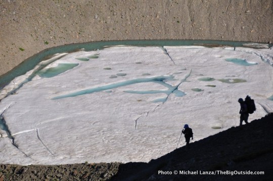
We follow a quiet country lane past some private homes and small lodges, beyond which the road narrows to a footpath. As we ascend a valley, the way grows increasingly steeper; we clamber over large talus boulders. After slogging uphill for a solid four hours, we wade into a small crowd of trekkers lounging in the cool breeze at the Fenétre d’Arpette, a notch in a mountain ridge. On the other side, the broad, crevassed tongue of the Trient Glacier hangs down into the valley we’re descending. Not far down the other side, we hear a loud crack and look up to see ice calve from the glacier and rain down cliffs exposed only in recent years as the glacier, like most others in the Alps, continues a fast retreat as the climate warms.
At the Col de la Forclaz, a pass with a busy, two-lane highway and a powerful wind both cutting through it, we’re met by Ilse Bekker-Maassen, who owns the Chalet Bekker with her mountain-guide husband, Edward. She transports us to her inn, a homey place in the woods overlooking Finhaut. That night, Ilse serves us a dinner of raclette, a traditional meal of Switzerland’s Valais region, consisting of raclette cheese melted over bread and potatoes which everyone would have devoured even if we weren’t ravenous from a big day’s hike.
It’s now official: We have been spoiled by the food along the Tour du Mont Blanc.
A Big, Last Day to Chamonix
For our trek’s ninth and final day, Ilse suggests an alternative to stage nine of the Tour du Mont Blanc. Instead, Ilse points out on the map a roughly six-mile trail from the Emosson dam, a short drive from Finhaut on the border of Switzerland and France, to the little village of Le Buet, where we can catch a short, inexpensive train into Chamonix. The trail follows a high ridge across the valley from the TMB, offering constant views of the Mount Blanc massif rather than hiking along its flanks, as we would on the TMB. So we decide to do it, and a bluebird morning sky portends one of the trip’s nicest days.
Ilse offers to drive us to the dam, but notes that anyone interested can also begin from Finhaut with an uphill hike of almost five miles and 2,000 feet just to reach the dam. Some of us opt for the longer day—including, of course, my mom, who I had actually, fleetingly imagined might be feeling kind of tired.
We hike the relentless ascent at her snail’s pace. Below us, Finhaut slowly retreats into the distance, revealing the village as a cluster of homes and hotels clinging to the steep mountainside. At the dam, we meet up with those who drove up with Ilse and eat lunch in the restaurant. Mom looks as fresh as if she’d accepted the ride instead of hiking there.
Plan your next great backpacking adventure using my downloadable, expert e-guides.
Click here now to learn more.
Alex below the Fenetre d’Arpette, Tour du Mont Blanc, Switzerland.
Beyond the dam, the trail immediately presents us with a short traverse across an exposed rock face—a no-fall zone with a fixed chain in place as a handrail. A trekker coming from the other direction says there are numerous similar sections for the next couple of miles. Julie, who’s recovering from a shoulder injury suffered a few weeks before the trip and has hiked with one arm in a sling all week, decides to turn back and take public transportation from the dam down to the valley; Inken and Guido join her.
For the next couple of hours, Marco, Alex, Anna, and I shadow my mother, lending her a hand or spotting or boosting her when she needs it; but she does most of the work of hauling herself up and down under her own power. I can see the kids are proud of being part of her team. They keep pulling out their phones to shoot video and pictures of her scaling these short walls of rock.
We reach a nearly vertical wall of rock about 15 feet high, requiring third-class scrambling up a rising diagonal traverse. My mom looks up at it and, rather than reacting with fear, busts out laughing at the absurdity of it all. “Oh, my gosh,” she says, chuckling. “This is unbelievable.” But with her young aides surrounding her like Secret Service agents, she scales yet another section of this trail that would turn away many people half her age.
To borrow an expression from the French: “C’est incroyable!”
Are you ready now to hike one of the world’s great treks?
Click here now for my e-guide “The Perfect, Flexible Plan for Hiking the Tour du Mont Blanc.”
The Power of Positive Thinking
Years ago, I gave my mother the nickname “The World’s Toughest Grandma” for her hiking feats. (And as we hike the TMB, she is actually soon to be a great-grandmother. Chew on that fact for a minute.) But the source of what many of us describe as toughness or fortitude may reside in an attitude more fundamental to individual human nature—an attribute I’ve seen her manifest countless times over the years, like the day she stared down her fears to scale the cable route up Yosemite’s Half Dome when she was nearing 60. Where some people see a glass as half empty, my mother sees it as half full.
Science has proven that the brain influences the body’s physical health: Thinking positive thoughts boosts the immune system, counters depression, and lowers blood pressure. Focusing on the positive in their lives has helped some people with chronic illnesses live longer, while a positive view of aging can lead to better health and longevity.
Researchers at the Johns Hopkins School of Medicine found that, among people with a family history of heart disease, those who had a positive outlook were one-third less likely to have a heart attack or other cardiovascular event than those with a negative outlook; positive people in the general population were 13 percent less likely than their negative counterparts to have a heart attack. According to a University of Kansas study, a simple smile reduces heart rate and blood pressure during stressful situations.
Have all the planning done for you. Sign up for one of these 14 best trips to Mont Blanc.
What does that mean for an old lady trying to hike day after day through the Alps?
My mother doesn’t visualize failure. Even at 80, she visualizes success. She believes she will make it, and aided by her fitness level, it becomes a self-fulfilling prophesy—and not because it’s easy for her, not by a long stretch. Watching her hike, you can see she’s not walking up and down mountains pain-free. Jeff will tell me later that his GPS measured today’s hike from Finhaut to Le Buet at 10.9 miles with close to 4,000 vertical feet of cumulative elevation gain. For almost anyone, at any age, that’s a huge day. Hiking five of our nine days out here, she will cover more than 43 miles of the 106-mile Tour du Mont Blanc (no one in our group did the entire route), with well over 10,000 vertical feet of climbing.
And yet, to her, the pleasure she derives from it eclipses the suffering. Her optimism is something that many people, of all ages, in any context, could take a lesson from.
Anna Garofalo hiking from Emosson dam to Le Buet, Switzerland.
All afternoon on the high, rugged traverse from the Emosson dam, we stop repeatedly to gape across the valley plunging away thousands of feet to the glaciers and jagged skyline of Mont Blanc muscling into the brilliantly blue sky. A sprawling massif more than 15 miles (25k) long, plastered with more than 40 glaciers, Mont Blanc comprises some 400 distinct summits, including some of the most famous names in mountaineering history: the Grandes Jorasses, Aiguille Noire, the Dru and Aiguille du Midi. Its true summit towers 12,000 feet above Chamonix, France, and nearly two vertical miles higher than the nearest habitations in Italy, and overlooks seven valleys in three countries.
At one point, while catching her breath, Mom looks around and says, “It’s hard, but it’s beautiful. I’m really glad I did this today.”
The Big Outside is proud to partner with sponsor Switzerland Tourism, who supported this trip and this story about trekking the Tour du Mont Blanc. Click on the Switzerland logo to find out more about traveling in that beautiful country.
With evening rapidly approaching, Anna, Marco, Mom, and I reach the Refuge de la Loriaz hut—we had told the others a while back to go on ahead of us—and begin a long descent on a gravel road through the forest. Shortly after 7 p.m., almost 10 hours after setting out from Finhaut, the four of us reach the train stop in the village of Le Buet shortly before the day’s last train pulls up at 7:41 p.m. Twenty minutes later, our nine-day journey comes full circle with us arriving back in Chamonix.
We stroll down bustling streets past scores of people talking and laughing at outdoor restaurant tables. Approaching our hotel, we see Guido and Inken sitting at a table outside, smiling at us. They congratulate Mom; Inken gives her a warm hug.
Save yourself a lot of time. Get my e-guide “The Perfect, Flexible Plan for Hiking the Tour du Mont Blanc.”
“Watching her walk over to us, it doesn’t look like she just did this huge hike,” Guido tells me.
I just nod. How do you explain people like her? She hasn’t overcome physical pain or exhaustion, of course. She has simply decided it will not stop her from going after a sense of satisfaction that’s larger than the pain. She understands that age eventually wins out over us all. But she’s not giving in without a damned good fight.
She has a simple but powerful force on her side: the right attitude. Not to mention a good, steady snail’s pace.
Tell me what you think.
I spent a lot of time writing this story, so if you enjoyed it, please consider giving it a share using one of the buttons at right, and leave a comment or question at the bottom of this story. I’d really appreciate it.
See a menu of all of my stories about family adventures and international adventures at The Big Outside.
Get my personal, customized help planning this trip. See my Custom Trip Planning page for details.
Marco Garofalo at the Fenetre d’Arpette, on the Tour du Mont Blanc in Switzerland.
Trip Planner: Trekking the Tour du Mont Blanc
THIS TRIP IS GOOD FOR anyone in moderately good physical condition, including children, with the caveat that some may want to skip or shorten harder days by using the public transportation and taxi options available along the Tour du Mont Blanc. The route is well marked and virtually always obvious—especially the primary route—so basic map-reading skills are adequate to find your way without any major problems. There are also enough other trekkers on the TMB, speaking several languages, that you can often ask directions if needed.
Subscribers to The Big Outside can read the rest of this TMB Trip Planner (below), with my tips on planning the Tour du Mont Blanc, and get access to all stories.
Want to get far more trip-planning and route details? Get my e-guide “The Perfect, Flexible Plan for Hiking the Tour du Mont Blanc.”
Join The Big Outside now to read ALL stories and get a free e-guide!
. . .
Resources Switzerland Tourism, https://www.myswitzerland.com/en-ch/home.html, and Valais hiking tours, valais.ch/en/activities/hiking/hiking-tours.
0 notes
Photo

♡ ‘til death, we do art. knight zim Styles 100
https://www.ikissbobo.com/product/eco-chic-strapless-adhesive-invisible-bra/
0 notes