#north american navion
Photo

Veronica Lake and her husband, Hungarian-American film director Andre de Toth (1913-2002), in the North American Navion four-seat aircraft which was a Valentine's gift from Lake to De Toth, United States, 1947
225 notes
·
View notes
Text
Anchor'dventures

The view from Boutny's deck, drying out at Point quay
The lessons have been accumulating, and I have not been good at logging them. There was the spinnaker left too long to fly in the early crossing of Biscay; the gib that came out of the furler reel a few hours later; the lesson that I will learn one day, to reef early and reef often; the auto-pilot that broke down ... all fine until the wind dropped and the shipping lanes filled. There was dragging in Camaret, there was chicken with cargo-ships in a storm, there was setting course for the harbour entrance buoy at Falmouth and almost hitting it at the end of a long night. There was dragging at Trefusis Point, and not having a starboard engine that idles correctly. There was the storm on the buoy in Falmouth and bad innovations in my bridle ... There was trusting my depth sounder and running a-mud when it showed 0.6m ... there really are many lessons to catch up on, and let this list be a reminder for some winter postings.
This lesson is fresher than the others, so here goes. It is my third anchor drag. First lesson: I really must work out what is going wrong with my technique. From no drags on the sandy Mediterranean and Algarve, Brittany and Cornwall, with their powerful winds and tides, their complex bottoms, have brought the average of drags per anchorage to an uncomfortable high.
Here is how the weather turned out last night, and it was more or less as forecast.

I had just spent three wonderful nights - the first good weather in weeks - at the beautiful anchorage in front of Trelissick House.

The forecast was for 30+kts, with gusts perhaps to 40+, from the South West, so best to move across the river to find protection for the night.
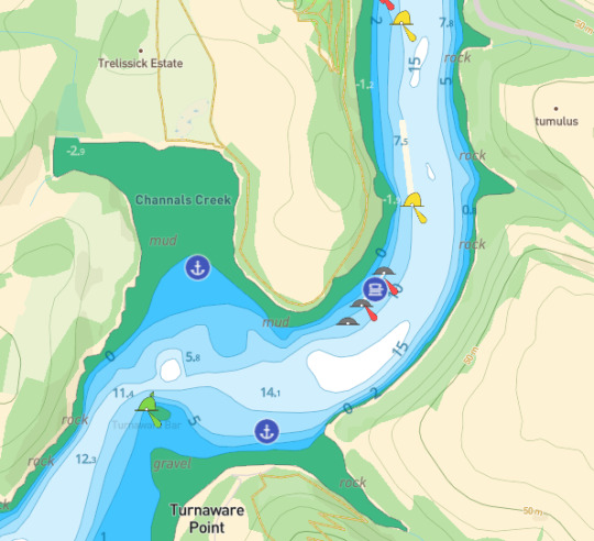
I got there early, together with a handful of other boats. I came in closer than anyone, around high tide, taking advantage of Boutny's shallow draft and her ability to sit even on the ground. The obvious point of greatest protection, in the shallow tongue on the east side of Turnaware Point, was occupied, so I picked a place on the point.
The wind during the afternoon was not strong, and the rain was bucketing. I took a stroll along the gravel beach, shingle and kelp with occasional concrete blocks from a feature that Navionics has as a WW1 embarcation dock.
Ah... now I remember another and separate lesson: I tied up my tender on returning from the beach, and settled down to continue writing the report that is taking up my attention right now, when I heard some shouts from shore. My dinghy was drifting down-river with the tide ... How could my knot have come loose? Why hadn't I done what I usually do - have two separate lines to secure the tender? So ... a subsidiary lesson for the day - don't slacken on old rules of thumb, just because your feeling confident.
Andy, from a boat next door, shouted that he would go and get her. How attentive and kind. He came back to Boutny towing my tender, and we talked of the night to come.
"Who will drag, I wonder", he asked. I agreed that we'd all have to look out for each other. I did not think that anyone would drag onto me - if they did, they'd be heading straight onto the beach. I felt quietly confident, though I said that I should probably go and dive onto my anchor to have a look. He talked about adding a second anchor in a V configuration, and I told him I might put one in front of the other, as Jean-Yves had recommended.
I went back below. I felt tired and the words weren't flowing for my report. I ate some left-over pasta and lay down with American Pastoral and was dosing by about 6pm. I had, however, set my anchor alarm properly, this time, after the Cameret lesson. Around 8pm I got up to have a look around, and saw with some satisfaction the waves and white horses on the North bank where I had come from that morning. The trees at the shoreline to windward seemed to be protecting me from the wind, though an occasional gust would come around the point and yank at Boutny's bridles. I turned on my masthead anchor light and returned to my bunk.
The anchor alarm woke me at 10pm. I got out of bed, silenced it, and looked at the track. Perhaps I had set it too conservatively and I was in fact holding. I went on deck and checked my distances. Storm Betty was at full power, by now, and the wind was regularly coming around the point and pulling at Boutny's tethers.
When the alarm went off again at 10.30, I finally took it with the seriousness it had originally required. Another little lesson here, though it feels like a repeat: resist wishful thinking, and do not lie in hope without having tried to fix the problem or properly gathered evidence that there is none. I was seriously drifting, and was now level with the old ramshackle ketch with the 2 noisy wind generators.
Adrenalin gets you moving fast. I started the starboard engine to get some sort of directional control, even with the 30m of chain and anchor dragging. One I was headed towards open space - more or less straight for the Northern shores - I went to the foredeck and tried to get my windlass to bring the chain in.
I have been having connection problems - known about but unfixed - and my remote also stopped working after I started playing with the batteries in A Coruna ... However much I pressed the red button, I could not get the windlass to turn. I am afraid there is an obvious lesson here - fix problems when you've noticed them, not after the crisis when you wish you had fixed them already. ("A stitch in time", and all that...)
So ... it was dark, wet and I was heading into the path of Betty's full force, dragging a lot of chain and stuff. Urgh. I stood astride the windlass and pulled chain in at whatever rate I could muster, all adrenalined-up. I rounded the elegant yacht with the blue ensign that had confidently anchored in the windy channel, having hauled most of it in, relieved not to have become tangled with hers. Lesson: you got away with it, but counting on luck is a poor strategy.
What now? Just as I was considering the question, a voice on my port stern said: "Are you alright, Tony?"
That was it. The hallucination that comes to so many in situations of crisis. Mountaineers talk about the figures who appear, seeming entirely real, from their imagination to help them through tough passes. I had wondered whether any such figure would appear when I solo'd those last crossings. Although I occasionally mistook the creaking of a beam for a voice that spoke, no one had come.
But it really was too real. I went to look astern, and there was Andy in his tender, doing what he'd said he'd do, looking after whoever it was who'd need it in the night.
"Go up river, after the pontoons ... there's a small creek where you should be able to lie alongside the trees, protected. Do you want me to come with you?"
Better than a hallucination ... Andy had local knowledge.
"Thank you, no. I'll be fine and follow your advice. You return to looking after your boat."
Another lesson, a big one: try to be as kind and helpful as Andy. How very reassuring it was to be offered advice in that moment.
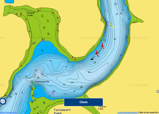
Betty's power was in my stern, and I made my way quickly past the pontoon. And there was the micro-creek, that place, right up in the top-right of the Navionics screenshot, that thing that looks like a thorn on a rosebush:
And here it is in satellite view, perhaps more telling for the account of the next 3 hours I spent in the creek, St Just-in-Roseland, Google tells me:
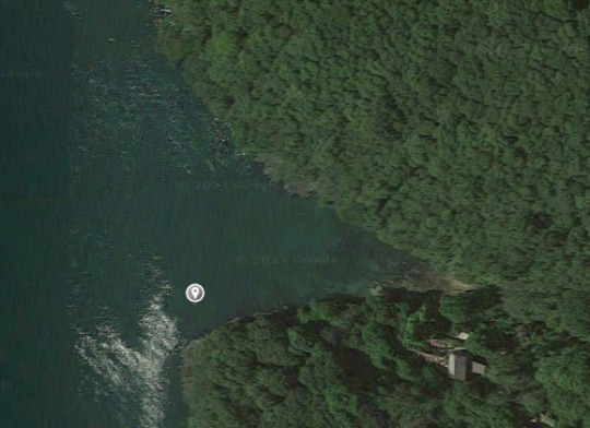
There was a party on in that house behind the trees. Lively. I thought at one point they were calling out to me, but they weren't. I wonder if they even knew the micro-drama yards away from them.
I placed my anchor about where I have the marker. It was the most protected corner, and the northern shore was windy. There was enough light to see the great branches of the overhanging trees swaying and waving as gust upon gust came down or around.
But how much chain to put down? Too much, and I would be pushed into those trees. Too little, and it would be unlikely to hold. I tried 10m, I tried 20m, I tried putting here and putting it there. I tried both anchors. But I never felt confident the chain would keep me away from the banks.
I remember Olivier talking to me about anchorages slipping in strong wind: "If you have to, if your anchorage isn't holding and you've run out of options, you'll just have to keep on your engines, drive onto the chain, relieve it, adjust your position. You'll have to keep going all night if you must. But just don't give up. Remember that you need to save your boat from the shoreline. That's your priority".
So that was now my plan. To use the engines to stay in the right place, to avoid hitting the sides of the creek. And here starts the next lesson ... a rather unsurprising one about tidying lines and fouling an engine prop.
I often find the mainsail sheet - it is very long, and needs to be - dragging in the water. This time, however, it dragged and tangled in my starboard prop. OK, there were odd clicking sounds, some coming from unusual places, but rather than stop the engine and check what was up, my priority was staying clear of the banks, I thought, so I kept revving. Until the poor engine cut out.
Then, in a lull, I opened the hatches and looked at what was up - it would be prudent to have two engines working in these conditions. And here is what I found - the ugly bundle that Anna and Esme, the artists who came on board the next day, immediately called "Misericordia":

This, sadly, is the line that used to go through the triple block on the main sheet, and the rotations had pulled it quite tight around the prop, and had stretch the clew to the point where the tension in the foot of the sail stopped it going any further.
The conditions felt stable enough, so I stripped down and put my wingfoil board into the water, paddled under the boat with my Opinel, and cut through the mess. The party was going full pelt, and I was, at some level, loving the cold lashings and adrenaline of it all. And, of course, the pride and comfort when the motor started again.
By 1pm, Betty, still powerful, was losing some of her peaks, and the tide was low. I might run aground in this minuscule creek, and I would have to watch like a hawk the moment of refloating. So I headed back to where I had originally slipped, dropped my anchor, dried out, and woke every 20 minutes after 4am to catch the moment the tide would float Boutny again. I was worried both that I might drift up the beach and not refloat, and that if I did, I would swing on an untested anchor hold and into my neighbours. I dropped my spare anchor off the stern to avoid the first problem, and waited for the waters to rise to avoid the second.
I was asleep again at 6 and woke, somewhat refreshed and with slightly surreal memories of the night, at 7.30, ready to catch high tide to collect Anna and Esme from the quay at Point.
Many lessons in all that. Keep the lines tidy. Properly check anchor hold, not just with a big reverse thrust. Give up on wishful thinking. Be as kind as Andy.
But maybe another one too. I hadn't checked out the "escape routes" from a dragging in the hours before the storm. If I had, perhaps I would not have gone to the mini-protection of the microcreek. Perhaps I would have pressed on and found easier protection and a better night's sleep upstream:
0 notes
Text

There's a 1948 North American L-17 Navion (N4318K) on the ramp at Trenton-Robbinsville (N87) and this is the sad state of it. Don't think it's flown since 2008.
0 notes
Video

flickr
North American Navion ‘N8968H’ by Alan Wilson
Via Flickr:
c/n NAV-4-968 Built in 1947 as one of the original 1,109 Navions built by North American before production moved to Ryan. Despite the colour scheme she is a purely civilian aircraft with no military history. Enstone Aerodrome, Oxfordshire, UK 10th June 2021
1 note
·
View note
Text

1946 North American Navion L-17
6 notes
·
View notes
Text
Witness The Excellent Long-Term Growth Outlook Of Marine Chartplotter Market 2025
Global Marine Chartplotter Market Research Report: Information by Component (Hardware and Software), Application (Navigation, Fish Finders, and Others), End Use (Yachts and Boats), by Region (North America, Europe, Asia-Pacific, Middle East & Africa, and Latin America) — Forecast till 2025

Marine Chartplotter Market Scenario
The global marine chartplotter market is expected to witness significant growth during the forecast period owing to factors such as the upgrade of existing boats and widespread adoption of sonar systems for search and rescue operations. Additionally, rising use of anti-submarine warfare systems is expected to positively influence market growth.
Based on region, the global marine chartplotter market has been segmented into North America, Europe, Asia-Pacific, the Middle East & Africa, and Latin America.
In 2018, North America dominated the global market. The North American market includes the US and Canada. The US is expected to constitute a larger share of the regional market during the forecast period. Furthermore, the presence of key marine electronics companies such as Garmin Ltd and FLIR Systems (Raymarine) in the country is projected to drive market growth during the forecast period.
The European market includes the UK, France, Germany, Italy, and the rest of Europe. Italy accounted for the largest share of the European marine chartplotter market in 2018. The presence of key companies such as Navionics SRL in Italy is expected to drive market growth.
Free sample report here: https://www.marketresearchfuture.com/sample_request/8273
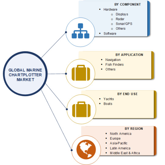
The marine chartplotter market in Asia-Pacific includes China, India, Japan, Australia, and the rest of Asia-Pacific. China accounted for a dominant share of the market in 2018. China supplies various electronic components used for manufacturing chartplotter systems. Furthermore, the rise in purchase of personal boats in China is expected to drive the growth of the market in the country during the forecast period. The market in Asia-Pacific is expected to register the highest CAGR during the forecast period. Increase in naval investments are expected to drive the regional market growth during the forecast period.
The market in the Middle East & Africa includes the UAE, Saudi Arabia, and the rest of the Middle East & Africa. The UAE is anticipated to account for the largest share of the market in the region during the forecast period. Rise in tourists in the UAE is expected to drive the demand for luxury boats and yachts. This, in turn, is increasing the demand for marine chartplotters during the forecast period.
The market in Latin America includes Brazil and the rest of Latin America. Brazil is expected to account for a larger share of the market during the forecast period. The export business in Brazil is anticipated to drive the growth of the market in the country. Furthermore, investments in the country’s navy are expected to boost the market growth during the review period.
The global marine chartplotter market has been segmented on the basis of component, application, end use, and region.
Based on component, the global marine chartplotter market has been divided into hardware and software. Hardware was the largest segment of the market in 2018; however, the software segment is projected to be the grow faster during the forecast period. The hardware segment has been further segregated into displays, radar, sonar/GPS, and others. The SONARs/GPSs sub-segment is expected to register the highest CAGR during the forecast period.
On the basis of application, the market has been classified as navigation, fish finders, and others. Navigation was the largest segment of the market in 2018, whereas fish finders is estimated to be the fastest-growing segment during the forecast period.
In terms of end use, the market has been segmented into yachts and boats. Boats was the larger segment in 2018 and the yacht segment is projected to register a higher CAGR during the forecast period.
Brows full report here: https://www.marketresearchfuture.com/reports/marine-chartplotter-market-8273
About Market Research Future:
At Market Research Future (MRFR), we enable our customers to unravel the complexity of various industries through our Cooked Research Reports (CRR), Half-Cooked Research Reports (HCRR), Raw Research Reports (3R), Continuous-Feed Research (CFR), and Market Research and Consulting Services.
Contact:
Market Research Future
+1 646 845 9312
Email: [email protected]
0 notes
Text
Electronic Navigational Charts (ENC) Market Analysis, Opportunities and Future Prospects 2026
An electronic navigational chart (ENC) caries information on features useful for marine navigation, including coastlines, bathymetry, beacons, and obstructions. Electronic navigational charts are complied with International Hydrographic Organization (IHO) S57 specifications. The IHO S57 standard is used by ECDIS (Electronic Chart Display and Information System) manufacturers to display navigational data on the charts. Electronic navigational charts are much superior to raster or paper charts. Systems using ENCs can be programmed to provide information about an approaching threat in relation to charted information and a ship’s movement and position. ENCs are approved by the International Maritime Organization (IMO) as a paper chart equivalent. Further, as per the IMO, vessels and ships equipped with ENCs do not need to not carry paper charts as is normally required under the Safety of Life at Sea (SOLAS) Convention. The contract fee for electronic navigational charts is determined on the basis of contract period, number of units, and types of ENCs.
Obtain Report Details @ https://www.transparencymarketresearch.com/electronic-navigational-charts-market.html
Electronic Navigational Charts (ENC) Market: Drivers and Restraints
Safety requirements set up by the IMO, increase in trend toward safe navigational systems, and expansion of the maritime and aircraft industry worldwide are expected to propel the global electronic navigational charts market in the coming years. The paper catalogue is replaced by a digital catalogue (of which there are many available), the order is sent by e-mail, and the chart distributor sends a license for the ENCs by e-mail. The advantage of ENCs is that the CDs that hold the ENCs are usually already on board. The ship can then load the charts from the CDs onto the ECDIS when the license is issued, eliminating the need to physically send any goods. Many companies are trying to enter into the electronic navigational charts space through M&A activities. For instance, in 2017, Garmin Ltd., acquired the Italian electronic navigation charts company, Navionics S.p.A.. Moreover, the requirement of training pertaining to electronic navigational charts is likely to hamper the growth of the electronic navigational charts market. Shipping companies face challenges while training crew in the use of ECDIS. There are options to follow a generic ECDIS training or a type-specific training. However, the crew also needs to be trained in ordering and licensing procedures. The process of operating a digital catalogue, planning a voyage, determining license requirements, and loading the licenses onto the ECDIS requires training in its own right. This is especially true due to the many different types of catalogue software in existence, all with their own user interface and peculiarities.
Electronic Navigational Charts (ENC) Market: Segmentation
The electronic navigational charts market can be segmented based on application, component, and region. Based on application, the electronic navigational charts market can be classified into aviation, marine, and others. In terms of component, the electronic navigational charts market can be categorized into hardware, software, and services. Based on geography, the electronic navigational charts market can be segmented into North America, Europe, Middle East & Africa, Asia Pacific, and South America. North America and Europe are expected to lead the electronic navigational charts market due to an expansion in the maritime sector, increase in safety pertaining to navigational systems, and the presence of established players providing electronic navigational charts. Moreover, a rise in the popularity of electronic navigational charts for ships and aircrafts is expected to propel the electronic navigational charts market in Asia Pacific over the forecast period from 2018 to 2026.
For More Details, Request A Sample Report at https://www.transparencymarketresearch.com/sample/sample.php?flag=S&rep_id=51480
Electronic Navigational Charts (ENC) Market: Key Players
Some of the key players involved in the electronic navigational charts market are Electronic Charts Company, Inc., ChartCo Limited, Japan Hydrographic Charts & Publications Co., Ltd., OceanWise, Poseidon Navigation Services Ltd, Maritime Services Ltd., Sirm SPA, Jeppesen, SRH Marine Electronics S.A., Maryland Nautical, American Nautical Services, Inc., Fontanski Marine Supply, and Nautisk Forlag AS.
The report offers a comprehensive evaluation of the market. It does so via in-depth qualitative insights, historical data, and verifiable projections about market size. The projections featured in the report have been derived using proven research methodologies and assumptions. By doing so, the research report serves as a repository of analysis and information for every facet of the market, including but not limited to: Regional markets, technology, types, and applications.
The study is a source of reliable data on:
Market segments and sub-segments
Market trends and dynamics
Supply and demand
Market size
Current trends/opportunities/challenges
Competitive landscape
Technological breakthroughs
Value chain and stakeholder analysis
0 notes
Text
Electronic Navigational Charts (ENC) Market - Global Industry Analysis, Size, Share, Growth, Trends, and Forecast 2018 - 2026
Electronic Navigational Charts (ENC) Market: Overview
An electronic navigational chart (ENC) caries information on features useful for marine navigation, including coastlines, bathymetry, beacons, and obstructions. Electronic navigational charts are complied with International Hydrographic Organization (IHO) S57 specifications. The IHO S57 standard is used by ECDIS (Electronic Chart Display and Information System) manufacturers to display navigational data on the charts. Electronic navigational charts are much superior to raster or paper charts. Systems using ENCs can be programmed to provide information about an approaching threat in relation to charted information and a ship’s movement and position. ENCs are approved by the International Maritime Organization (IMO) as a paper chart equivalent. Further, as per the IMO, vessels and ships equipped with ENCs do not need to not carry paper charts as is normally required under the Safety of Life at Sea (SOLAS) Convention. The contract fee for electronic navigational charts is determined on the basis of contract period, number of units, and types of ENCs.
Get more Information about this Report @ https://www.transparencymarketresearch.com/electronic-navigational-charts-market.html
Electronic Navigational Charts (ENC) Market: Drivers and Restraints
Safety requirements set up by the IMO, increase in trend toward safe navigational systems, and expansion of the maritime and aircraft industry worldwide are expected to propel the global electronic navigational charts market in the coming years. The paper catalogue is replaced by a digital catalogue (of which there are many available), the order is sent by e-mail, and the chart distributor sends a license for the ENCs by e-mail. The advantage of ENCs is that the CDs that hold the ENCs are usually already on board. The ship can then load the charts from the CDs onto the ECDIS when the license is issued, eliminating the need to physically send any goods. Many companies are trying to enter into the electronic navigational charts space through M&A activities. For instance, in 2017, Garmin Ltd., acquired the Italian electronic navigation charts company, Navionics S.p.A.. Moreover, the requirement of training pertaining to electronic navigational charts is likely to hamper the growth of the electronic navigational charts market. Shipping companies face challenges while training crew in the use of ECDIS. There are options to follow a generic ECDIS training or a type-specific training. However, the crew also needs to be trained in ordering and licensing procedures. The process of operating a digital catalogue, planning a voyage, determining license requirements, and loading the licenses onto the ECDIS requires training in its own right. This is especially true due to the many different types of catalogue software in existence, all with their own user interface and peculiarities.
Request a Brochure for Research Insights at @ https://www.transparencymarketresearch.com/sample/sample.php?flag=B&rep_id=51480
Electronic Navigational Charts (ENC) Market: Segmentation
The electronic navigational charts market can be segmented based on application, component, and region. Based on application, the electronic navigational charts market can be classified into aviation, marine, and others. In terms of component, the electronic navigational charts market can be categorized into hardware, software, and services. Based on geography, the electronic navigational charts market can be segmented into North America, Europe, Middle East & Africa, Asia Pacific, and South America. North America and Europe are expected to lead the electronic navigational charts market due to an expansion in the maritime sector, increase in safety pertaining to navigational systems, and the presence of established players providing electronic navigational charts. Moreover, a rise in the popularity of electronic navigational charts for ships and aircrafts is expected to propel the electronic navigational charts market in Asia Pacific over the forecast period from 2018 to 2026.
Electronic Navigational Charts (ENC) Market: Key Players
Some of the key players involved in the electronic navigational charts market are Electronic Charts Company, Inc., ChartCo Limited, Japan Hydrographic Charts & Publications Co., Ltd., OceanWise, Poseidon Navigation Services Ltd, Maritime Services Ltd., Sirm SPA, Jeppesen, SRH Marine Electronics S.A., Maryland Nautical, American Nautical Services, Inc., Fontanski Marine Supply, and Nautisk Forlag AS.
Get Table of Content @ https://www.transparencymarketresearch.com/sample/sample.php?flag=T&rep_id=51480
0 notes
Text
North American Navion NA-145 -LV-RHX- -LV-YYL- en Aeroclub Rosario (9 y 10 de Mayo) - YouTube
North American Navion NA-145 -LV-RHX- -LV-YYL- en Aeroclub Rosario (9 y 10 de Mayo) – YouTube
via North American Navion NA-145 -LV-RHX- -LV-YYL- en Aeroclub Rosario (9 y 10 de Mayo) – YouTube
View On WordPress
0 notes
Text
Black L.A., 1947: Robberies of Merchants Raise Racial Tensions in Little Tokyo/Bronzeville
March 6, 1947: North American Aviation had a male choir called the Navioneers that performed at Second AME church at 43rd Street and San Pedro Place. On the editorial page, the Sentinel seeks to defuse racial tensions in Little Tokyo (or Bronzeville) over robberies by a black “gang of thugs” preying on Japanese American merchants. The Sentinel says that the holdup gang is robbing Asians because…
View On WordPress
0 notes
Text
#gallery-0-7 { margin: auto; } #gallery-0-7 .gallery-item { float: left; margin-top: 10px; text-align: center; width: 33%; } #gallery-0-7 img { border: 2px solid #cfcfcf; } #gallery-0-7 .gallery-caption { margin-left: 0; } /* see gallery_shortcode() in wp-includes/media.php */
Raymarine Dragonfly 5 Pro Gold. 5″ CHIRP Sonar/GPS Combo with DownVision plus conventional sonar. Wi-Fi built in. Includes Navionics North American Gold lakes, rivers and coastal map. Dragonfly Pro combines GPS navigation with Raymarine’s advanced dual-channel CHIRP sonar. Dragonfly Pro will change your underwater view and maximize your time fishing with Raymarine’s wide-spectrum CHIRP technology. Easily identify fish and underwater objects with photo-like sonar images from the DownVision channel and target fish with the conventional CHIRP sonar channel. A built-in 50-channel GPS delivers precision guidance and built-in Wi-Fi lets you stream live sonar right to your smartphone.
5″ All-weather, high-definition LED backlit display Optically bonded display for sharp color, wide viewing angles, and no internal fogging
Dual-channel sonar – wide-spectrum CHIRP DownVision sonar for photo-like images and a second CHIRP conventional sonar channel for targeting fish
Stream live sonar data to your smartphone with Raymarine’s Wi-Fish mobile app; With the Wi-Fish you can rewind, save and share the day’s catch with friends on your favorite social networks
Removable mounting ball is compatible with aftermarket ball and socket mounting systems for more mounting options
Internal storage for 3000 waypoints and 15 tracks; Use optional microSD memory cards for expanded storage
[amz_corss_sell asin=”B00TX532PI”] Raymarine Dragonfly 5 Pro Navionics+ Dual Channel Sonar/GPS Raymarine Dragonfly 5 Pro Gold. 5" CHIRP Sonar/GPS Combo with DownVision plus conventional sonar. Wi-Fi built in.
0 notes
Video
North American Navion by Willard Womack
Via Flickr:
Designed by North American for the supposed post war flying boom, which never arrived. The fact that in a side view it look a lot like a P-51 was not an accident. Even the bubble type canopy slid open as did the Mustang. That did make it a little difficulty for women to get in and out. The post war boom was a flop, and the rights was sold to Ryan Aeronautical Company in 1948.
1 note
·
View note
Text
What a cool experience it was to visit The Commemorative Air Force Houston Wing at 18000 Groschke Road, Hanger #B-5, Houston, Texas 77084. My only complaint…that I didn’t allow enough time to visit it longer as I had a party to attend.
“The Commemorative Air Force honors the men and women who built, maintained, and flew in these airplanes during World War II. The organization believes that is best accomplished by maintaining the airplanes in flying condition; taking the airplanes to the people allowing them to experience the sight and sound of the aircraft in flight.” (Source: www.houstonwing.org)
The museum is open on the 1st and 3rd Saturdays of each month from 10am – 3pm. Telephone Number is 281-579-2131
The Fairchild PT-19 “Cornell”
The Houston Wing is based at West Houston Airport, in Houston, Texas, USA. The Wing has six CAF aircraft assigned – Lockheed C-60A “Lodestar”, North American AT-6 “Texan”, Consolidated-Vultee BT-13 “Valiant”. Naval Aircraft Factory N3N “Yellow Peril”, Fairchild PT-19A “Cornell” and a major restoration project, a North American L‑17 Navion
The Fairchild PT-19 “Cornell”
“The Houston Wing is now able to offer Historic Flight Experiences in five authentic WWII aircraft; the AT-6 Advanced Trainer, the BT-13 Basic Trainer, the N3N Primary Trainer, the PT-19 Primary Trainer and the C-60 Lodestar! This is a once-in-a-lifetime experience for any aviation enthusiast or history buff!”(Source: http://houstonwing.org/wing-aircraft/historic-flight-experience)
Meet Mr. Chuck Waters, a volunteer at the Museum. I am soooo going back when Mr. Waters is there!!! He is truly a fountain of information and is fascinating to converse with if you get an opportunity!
BT-13 Valiant
AT-6 Texan
Want to know more about the Lockheed C-60A (<<— Click here)
The Lockheed C-60A is a twin-engine transport based on the Model 18 Lodestar
Want to know more about the Lockheed C-60A (<<— Click here)
I would LOVE to do this!!!!
N3N Canary
Be sure to ask Mr. Chuck Waters, gracious volunteer, about his connection to a lot of this museum! Promise you won’t regret it!!!
Great place to take the family and learn too 🙂
The old uniforms are in great condition too!
Please read about Virginia “Ginny” Rado’s tablecloth below and all the famous folks who signed it during her time as a Red Cross volunteer. What a great idea she had!
Pages out of Virginia “Ginny” Rado’s Scrapbook
You are guaranteed to have a great time visiting the Commemorative Air Force Houston Wings! Huge thanks to all the wonderful and giving volunteers that make this possible!!!
Until next time…
Thanks for stopping over!!
Elizabeth and Max
The Commemorative Air Force Houston Wing and Museum-Houston, Texas What a cool experience it was to visit The Commemorative Air Force Houston Wing at 18000 Groschke Road, Hanger #B-5, Houston, Texas 77084.
#Chuck Waters Volunteer with Houston Wing of The Commemorative Air Force#Consolidated Vultee BT-13 Valiant#Fairchild PT-19A Cornell#Houston Wing of The Commemorative Air Force#Lockheed C-60A Lodestar#Naval Aircraft Factory N3N Yellow Peril#North American AT-6 Texan#THe Commemorative Air Force Houston Wing#World War II Museum in Houston Texas#World War II Planes
0 notes
Video
flickr
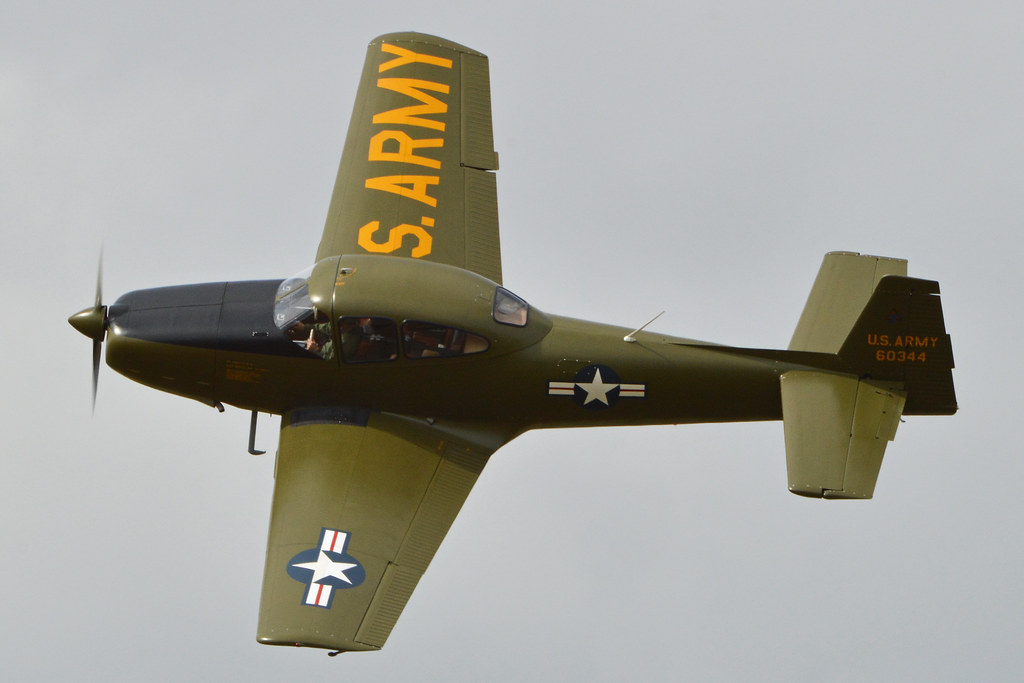
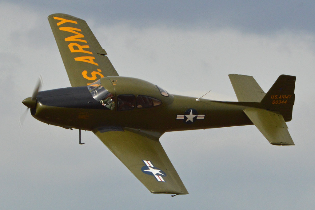
North American Navion '60344' (N4956C) by Alan Wilson
Via Flickr:
Although this Navion wears a convincing U.S. Army colour scheme, it actually has no military history. It certainly looks the part though! c/n NAV-4-344. Seen displaying at the 2014 Little Gransden Air & Car show. 24-8-2014
1 note
·
View note
Video

flickr
North American Navion ‘N91139’ by Alan Wilson
Via Flickr:
c/n NAV-4-36. Built 1946. Ryan took over Navion production in 1948, making this a North American built machine. Chino Airport, California, USA. 28-2-2016
1 note
·
View note
Video
flickr
North American Navion '60344' (N4956C) by Alan Wilson
Via Flickr:
Although this Navion wears a convincing U.S. Army colour scheme, it actually has no military history. It certainly looks the part though! c/n NAV-4-344. Seen displaying at the 2014 Little Gransden Air & Car show. 24-8-2014
0 notes
Last Seen Blogs

dallasviewmedia
Untitled

this-harl0t-shant-be-unalive
FALL INLOVE

backerhannah
Porquê Ficar?

illubean
binu

rayneydays
ray