
Last Seen Blogs

polka-spots
Oarfish are Cool

cosyanet
Virtual Angel

sibile-izumi
俺はもぐらだ

limgookgeun
제목 없음

veronicavon20
VeronicaVon
Text
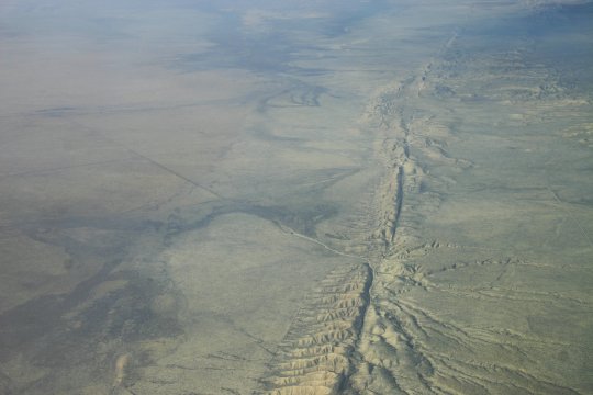
An aerial view of the San Andreas Fault on the west coast of North America. The fault is the boundary between the Pacific and North American tectonic plates.
35° 7′ 0″ N, 119° 39′ 0″ W
Wikimedia Commons file page
Credit: San Andreas Fault in the Carrizo Plain, aerial view from 8500 feet altitude. ( roughly 2590 metres) by Ikluft; CC BY-SA 4.0
5 notes
·
View notes
Text

This striking photo depicts a portion of the Antarctic coast, showing ice-strewn open ocean, the sea ice shelf, and finally mountain peaks visible in the far distance.
From the Wikimedia Commons description:
Ice shelf extending from Joinville Island into the Antarctic Sound, at the northeast end of the Antarctic Peninsula. To put distances in perspective: based on Google Earth imagery dated exactly four weeks prior to taking this photograph, the distance from the edge of the ice-shelf to the first visible mountain peak is approximately six miles. Note: The image was taken six miles from the edge of the ice shelf. Based on camera sensor size, lens magnification, and distance from the object, the height of the ice shelf edge (above water) was calculate in three places (see notations) to range from 50.8 feet to 89.6 feet.
Location: 63° 20′ 0″ S, 56° 45′ 0″ W
Credit: Antarctic Sound-2016-Joinville Island-Ice Shelf.jpg on Wikimedia Commons by Andrew Shiva. CC BY-SA 4.0
0 notes
Text

These wind warped trees are located near the southernmost point of New Zealand's South Island.
From the source:
This is at Slope Point, the southernmost point on New Zealand's South Island. The winds circle the great circumpolar Southern Ocean unimpeded for 2000 miles until they slam into land here. They are so constant and so ferocious that the trees are permanently warped into these gnarled, windswept shapes.
46° 40′ 7″ S, 169° 0′ 13″ E
Credit: Windswept by Anita Gould. CC BY-NC 2.0
0 notes
Text

This is an image of Cape Horn on Hornos Island. Located at the southern tip of South America, passage around Cape Horn is considered one of the most hazardous marine routes in the world. Hornos Island is also the site of the world's most southernmost tree, a Nothofagus betuloides.
55° 58′ 48″ S, 67° 17′ 21″ W
Wikimedia Commons file page
Credit: 00 2477 Cape Horn - Chile.jpg by W. Bulach. CC BY-SA 4.0
0 notes
Text

This is an image of a landform known as the Sleeping Giant, located on a peninsula in Lake Superior in the province of Ontario, Canada.
48° 20′ 14″ N, 88° 54′ 16″ W
Wikimedia Commons file page
Credit: Sleeping Giant, Thunder Bay.jpg by Dger. CC BY-SA 3.0
1 note
·
View note
Text

An isolated seascape perspective taken on Kingman Reef in the centre of the Pacific Ocean. Claimed as a US territory under the Guano Islands Act of 1856 under the name Danger Reef, it was briefly used as a refueling station for flying boats by Pan American Airways.
This photo was taken on October 19th, 2003 and shows a portion of the 3 hectares of land which make up the above water part of the reef.
6° 23′ 0″ N, 162° 25′ 0″ W
Wikimedia Commons file page
Credit: Kingman Reef Oct 2003.jpg by Joann94024; public domain
0 notes
Text
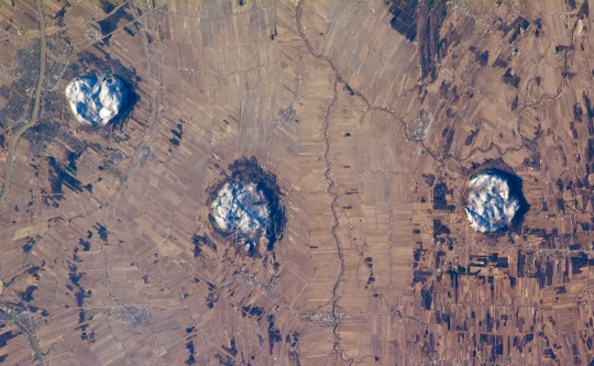
This image of three of the Monteregian Hills in Québec was taken by a crew member aboard the International Space Station.
Description from the image's original page:
This view captures two striking patterns, pointed out by NASA scientists who study the shuttle and station photography. The circular features are the central members of the Monteregian Hills located to the east of Montreal--Mont St. Hilaire, Rougemont, and Mont Yamaska. The rectangular pattern records the intensive agricultural land use of the fertile lowlands in southern Quebec. The Monteregian Hills are an isolated series of roughly east-west trending plutons--masses of igneous rock that crystallized below the land surface--located near Montreal. According to the scientists, magmas forming the Hills were intruded into pre-existing sedimentary rocks during the Cretaceous Era (roughly 123-125 million years ago). Over time, the sedimentary rock has eroded away, leaving the more resistant igneous rock of the plutons exposed as the Monteregian Hills in the surrounding flat St. Lawrence Plains. Rocks of these three plutons record a transition from silica-poor magmas (little to no minerals such as quartz or feldspar) to silica-rich magmas (abundant quartz and feldspar) along the line of the Hills. Snow cover on the three mountains provides additional contrast with surrounding tan to brown fallow agricultural fields. The city of Granby, Quebec is visible at left. In addition to their interesting geology, the Monteregian Hills also serve as important woodland habitat "islands" in the greater Montreal urban area.
This astronaut photograph of the area to the east of Montreal, Canada, captures two striking patterns. The circular features are the central members of a group of unusual rock formations known as the Monteregian Hills: Mont St. Hilaire, Rougemont, and Mont Yamaska. The rectangular pattern blanketing the landscape in the background reveals the intensive agriculture in the fertile lowlands in southern Quebec.
The featured astronaut photograph, ISS014-E-19807, was acquired April 18, 2007, with a Kodak 760C digital camera using an 180 mm lens, and is provided by the ISS Crew Earth Observations experiment and the Image Science & Analysis Laboratory, Johnson Space Center. The image in this article has been cropped and enhanced to improve contrast. The International Space Station Program supports the laboratory to help astronauts take pictures of Earth that will be of the greatest value to scientists and the public, and to make those images freely available on the Internet. Additional images taken by astronauts and cosmonauts can be viewed at the NASA/JSC Gateway to Astronaut Photography of Earth.
The featured astronaut photograph, ISS014-E-19807, was acquired April 18, 2007, with a Kodak 760C digital camera using an 180 mm lens, and is provided by the ISS Crew Earth Observations experiment and the Image Science & Analysis Laboratory, Johnson Space Center. The image in this article has been cropped and enhanced to improve contrast. The International Space Station Program supports the laboratory to help astronauts take pictures of Earth that will be of the greatest value to scientists and the public, and to make those images freely available on the Internet. Additional images taken by astronauts and cosmonauts can be viewed at the NASA/JSC Gateway to Astronaut Photography of Earth.
The featured astronaut photograph, ISS014-E-19807, was acquired April 18, 2007, with a Kodak 760C digital camera using an 180 mm lens, and is provided by the ISS Crew Earth Observations experiment and the Image Science & Analysis Laboratory, Johnson Space Center. The image in this article has been cropped and enhanced to improve contrast. The International Space Station Program supports the laboratory to help astronauts take pictures of Earth that will be of the greatest value to scientists and the public, and to make those images freely available on the Internet. Additional images taken by astronauts and cosmonauts can be viewed at the NASA/JSC Gateway to Astronaut Photography of Earth.
45° 28′ 7″ N, 73° 3′ 12″ W
Wikimedia Commons file page
Credit: ISS014-E-19807 by NASA. Public domain.
1 note
·
View note
Photo
This satellite image shows a snow-covered Akpatok Island in Ungava Bay, a large bay located in northern Quebec, east of Hudson Bay.
Description from the original Flickr photo page:
January 1st, 2001: Description: Akpatok Island lies in Ungava Bay in northern Quebec, Canada. Accessible only by air, Akpatok Island rises out of the water as sheer cliffs that > soar 500 to 800 feet (150 to 243m) above the sea surface. The island is an important sanctuary for cliff-nesting seabirds. Numerous ice floes around the island attract walrus > > and whales, making Akpatok a traditional hunting ground for native Inuit people.
Source: Landsat 7
To learn more about the Landsat satellite go to: landsat.gsfc.nasa.gov/
60° 25′ 0″ N, 68° 8′ 0″ W
Wikimedia Commons file page
Credit: Akpatok Island by NASA Goddard Space Flight Center; CC BY 2.0
5 notes
·
View notes
Photo

This image shows an ominous 23m deep cavity, known as the Devil's Nest (Pirunpesä in Finnish), located in the Jalasjärvi municipality of Finland. Stairs allow access to the bottom of the cavity.
62° 23′ 56.4″ N, 22° 53′ 44.16″ E
Wikimedia Commons file page
Credit: Devil's Nest in Jalasjärvi by Homolulu; CC BY-SA 3.0
0 notes
Photo

This photo taken from the ISS during October 2018 by ESA astronaut Alexander Gerst shows a section of Rhineland-Palatinate, Germany including the Nürburgring complex, located within the Eifel mountain range. The Nürburgring features a motorsports track, with one section of the complex being used as a Formula One Grand Prix track. The Nordschleife section of the track is also a one way toll road frequently open to the public, with a speed limit present only on certain sections.
50° 20′ 26″ N, 6° 56′ 48″ E
Wikimedia Commons file page
Credit: Der Eifel by ESA astronaut Alexander Gerst. ESA/A.Gerst; CC BY-SA 2.0
0 notes
Photo

This image shows an area of the Bogd Khan Uul Biosphere Reserve near Manjusri Monastery in Mongolia.
47° 54′ 58.83″ N, 106° 53′ 54.04″ E
Wikimedia Commons file page; another similar image on the Wikimedia Commons
Credit: Bogdkhan Uul Strictly Protected Area, Mongolia by yeowatzup; CC BY-SA 2.0
2 notes
·
View notes
Photo

This aerial shot of the Bingham Canyon Mine taken in 2018 shows the strikingly sinuous curves of its stepped benches and haul roads, as well as the ridges of the Oquirrh Mountains in the background and the Stansbury Mountains in the far distance. Operated by the Rio Tinto Group, this mine is the deepest open-pit mine in the world1 and the largest man-made excavation2.
http://www.mining.com/rio-tintos-kennecott-wins-clean-air-lawsuit-in-the-us/
https://www.deseret.com/2016/3/3/20583851/kennecott-laying-off-200-workers
40° 31′ 22.8″ N, 112° 9′ 3.6″ W
Wikimedia Commons file page
Credit: Eric.Prado on Wikimedia Commons; CC BY-SA 4.0
0 notes
Photo

Aerial view of the Crescent Dunes Solar Energy Project near Tonopah, Nevada in the Great Basin Desert. This concentrated solar power generating station is designed with a central tower used to collect thermal energy from focused sunlight, which is reflected via thousands of computer-controlled heliostats tracking the sun's movement throughout the day1. The project is currently not operational after having its contract ended by NV Energy, Nevada's public energy utility2.
https://www.solarpaces.org/how-csp-works/
https://pv-magazine-usa.com/2020/08/03/post-bankruptcy-and-doe-loan-owner-of-crescent-dunes-wants-csp-plant-online-by-years-end/
38° 14′ 0″ N, 117° 22′ 0″ W
Wikimedia Commons file page
Credit: Amble on Wikimedia Commons; CC BY-SA 4.0
0 notes
Photo

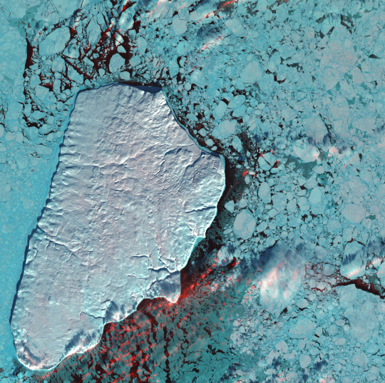
This photo taken in November 2016 shows an aerial view of a rift in the Larsen C ice shelf in Antarctica. At the time, this particular rift's growth was accelerating. It continued growing, eventually forming Iceberg A-68, one of the largest icebergs ever recorded, which has since separated from the ice shelf.
Iceberg calving is a normal, natural phenomena so there is some debate as to whether this particular event was induced by climate change.
68° 2′ 56″ S, 61° 40′ 35″ W (estimate)
Wikimedia Commons file page
Credit: John Sonntag/NASA; public domain
4 notes
·
View notes
Photo

This image shows a part of the Larsen C ice shelf on the Antarctic Peninsula. The simple, stark composition, grainy texture and false colouration make this a particularly visually striking capture.
This is an altered version of the original image by Antti Lipponen, with the lower credit portion removed to fully emphasise the image itself.
67° 30′ 0″ S, 62° 30′ 0″ W
Wikimedia Commons file page
Credit: Larsen C ice shelf 2017 06 04 by Antti Lipponen. Contains modified Copernicus Sentinel (1A) data.; CC BY 2.0
0 notes
Photo

This photo of the Antarctic Peninsula and South Shetland Islands was taken by a member of the crew of the International Space Station as it moved over the nadir point 49.2° S, 45.6° W.
This is an enhanced version of the original image taken by a Nikon D3 camera on October 4, 2011.
Check out the Wikimedia Commons file page to see labels indicating the islands depicted.
63° 44′ 0″ S, 61° 41′ 0″ W (coordinates of Hoseason Island near the centre of the image)
Raw image source
Wikimedia Commons file page
Credit: NASA, ISS Expedition 29 crew; public domain
1 note
·
View note
Photo

A rendering of the underlying land topography of Antarctica from data collected for the Bedmap2 project (the vertical scale has been increased by a factor of 17 to improve feature visibility). Some interesting comparison visualisations are available in this NASA article about the Bedmap2 project.
The next iteration of Antarctic map data collection, Bedmap3, is currently underway.
82° 26′ 44″ S, 99° 44′ 40″ W (approximate centre of image)
Bedmap2 paper
Credit: NASA's Goddard Space Flight Center Scientific Visualization Studio; public domain
6 notes
·
View notes